Local events in Glouster
Nothing is posted for Glouster itself yet; here is what is on within 20 miles. All local events in Glouster
Know a calendar we should watch? Send the link
Checked October 20; the events page is refreshed daily.
Lakes near Glouster
The history under the water: the valley before, the dam, the stories. All Ohio lakes
How Glouster began
Glouster grew up in Trimble Township in the Sunday Creek Valley coal field, about 15 miles north of Athens, after coal shipping began there on September 15, 1882, and a 60-acre village was laid out. It was first called Sedalia and was renamed Glouster, a variant spelling of Gloucester, England, in 1886, when a post office opened under that name in 1887. Coal, brickmaking (the Wassall Brick Company operated 1895-1932), and the Kanawha and Michigan Railroad carried the village to a peak population of 3,140 in 1920. Like the rest of the Hocking Valley coalfield, Glouster shrank steadily after the mines closed, falling to 1,659 residents by 2020.
Platted 1882, sixty acres laid out as coal shipping began.
Where the name comes from
The village was first named Sedalia. It was renamed Glouster in 1886, a variant spelling of Gloucester, England; a post office opened under the new name in 1887.
Before the town
No site-specific Native American history (named villages, trails, or mounds) has been found for Glouster or the immediate village site. The 1881-83 county history records the Shawnee as occupying "the present county of Athens and adjacent region" broadly, and documents Adena/Hopewell-era mounds and an earthwork on "the Plains" in Athens and Dover townships, well south of Trimble Township — those are not specific to Glouster or Trimble Township.
Nations recorded here: Shawnee, Adena culture, Hopewell culture.
Timeline
- — Coal shipping begins from mines in the area on September 15; a 60-acre village is laid out under the name Sedalia.
- — The village is renamed Glouster, a variant spelling of Gloucester, England.
- — A post office opens under the name Glouster.
- — The Wassall Brick Company begins operating in Glouster, supplying structural brick across southeast Ohio.
- — Glouster floods; a street-view photograph from March 14, 1907 documents the damage.
- — Glouster records its peak population, 3,140 residents, at the height of the Sunday Creek Valley coal boom.
- — The Wassall Brick Company ceases operations after roughly 37 years in business.
- — Glouster Stadium on High Street is built by the WPA.
- — Census population stands at 1,659, continuing a decline that began after coal mining wound down.
Stories
A mining village built almost overnight
Glouster did not grow slowly from a farm crossroads; it was platted deliberately in 1882, the same month coal began moving out of the Sunday Creek Valley field by rail, when a 60-acre village site was surveyed under the name Sedalia. Within a few years it was renamed Glouster after Gloucester, England, and a post office followed in 1887. The Kanawha and Michigan Railroad and the inexhaustible-looking Sunday Creek Valley coal seam pulled miners and their families in fast enough that by the 1890s the village was already claiming a population of about 3,000, unusually large for a mining town of that era. Coal remained the reason Glouster existed for the next four decades, supplemented after 1895 by the Wassall Brick Company, which turned local clay into structural brick shipped across southeast Ohio until it closed in 1932.
The Palos Covered Bridge and the W.P. Rice Mine
A mile north of Glouster, off State Route 13, a single-span kingpost-truss covered bridge crosses the east fork of Sunday Creek. Built to serve the W.P. Rice Mine, a coal operation that worked from 1913 to 1925, the Palos Covered Bridge outlasted the mine it was built for and was listed on the National Register of Historic Places on November 11, 1977. It is one of the few physical survivors of the dozens of small mine operations that once worked the hills around Glouster, most of which left nothing behind but tipple foundations and slag.
Photographs
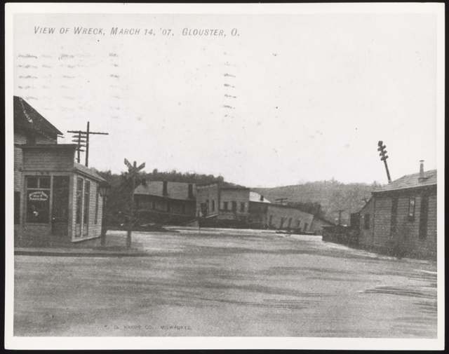
Photo: Wikimedia Commons, Category:Glouster, Ohio, public domain · Wikimedia Commons
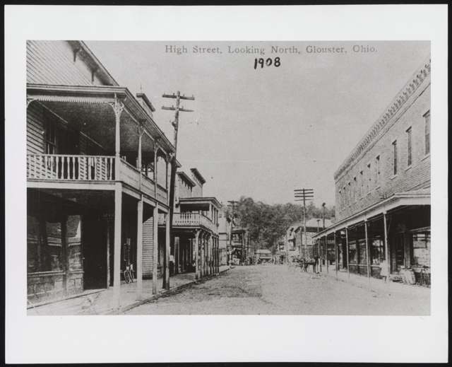
Photo: Wikimedia Commons, Category:Glouster, Ohio, public domain · Wikimedia Commons
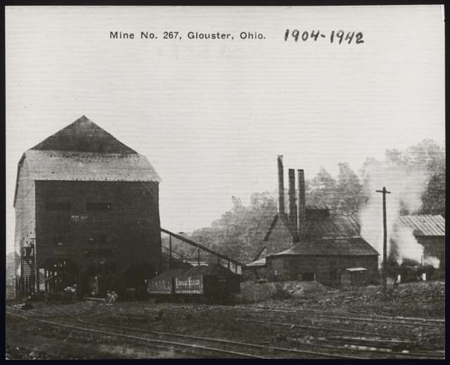
Photo: Wikimedia Commons, Category:Glouster, Ohio, public domain · Wikimedia Commons
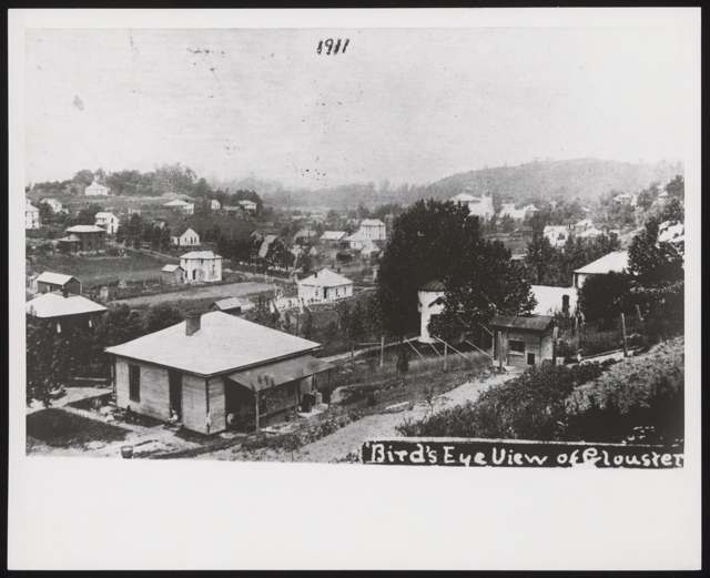
Photo: Wikimedia Commons, Category:Glouster, Ohio, public domain · Wikimedia Commons
Local history sources: en.wikipedia.org · en.wikipedia.org · en.wikipedia.org · commons.wikimedia.org · genealogytrails.com · archive.org
Water
Mostly private wells The water here
- Glouster Public Water System84% of residentsHocking River Buried Valley Aquifer (wells)
- Sunday Creek Valley Water14% of residentsHocking River Buried Valley Aquifer (wells)
- Trimble Village1% of residentsHocking River Buried Valley Aquifer (wells)
- Southern Perry Co-irish Ridge0% of residentsHocking River Buried Valley Aquifer (wells)
Hospitals, fire stations and more
Inside Glouster's boundary: 1 fire or EMS station, 2 public schools, 1 poor-rated bridge, 1 library and 1 police station. Press a pin or a name for its whole record and its source.
Fire and EMS stations (1)
-
Glouster Fire DepartmentGlouster
- Address
- 32 Water Street, Glouster, OH 45732
- Coordinates
- 39.50294, -82.08078
USGS National Map structures (source) ↗ Street map and directions ↗
Source: USGS National Map structures (most Ohio records last updated 2019 to 2022), checked against the Columbus and Cleveland station lists. The department that answers a call is set by jurisdiction and mutual aid, not by distance.
Public schools (2)
-
Trimble High School3 of 5 stars · Glouster
- Address
- 1 Tomcat Dr, Glouster, OH 45732
- School district
- Trimble Local School District
- Kind (NCES)
- Regular School
- Students, 2023-24
- 198
- Teachers (full-time equivalent)
- 15
- Report card, 2025-26
- 3 of 5 stars
- Performance index
- 62.1%
- Four-year graduation rate
- 90.2%
- Ohio building IRN
- 013755
- NCES school ID
- 390459202384
NCES school record ↗ Ohio School Report Card ↗ Street map and directions ↗
-
Trimble Learning AcademyGlouster
- Address
- One Tomcat Drive, Glouster, OH 45732
- Kind (NCES)
- Regular School
- Students, 2023-24
- 5
- NCES school ID
- 390459206106
Source: NCES EDGE public school locations 2024-25 and Common Core of Data 2023-24 (type, students, teachers); Ohio School Report Cards 2025-26 (Department of Education and Workforce), matched by name within the district.
Bridges rated poor (1)
-
Madison Street over W.bch Sunday CreekPoor · built 1954
- Condition
- Poor: a deck, superstructure, substructure or culvert rated 4 or below on the 0 to 9 scale
- What it is
- Bridge
- Built
- 1954
- Length
- 28 ft
- Owner
- City
- Vehicles a day
- 150
- Coordinates
- 39.50264, -82.08161
National Bridge Inventory (source) ↗ Street map and directions ↗
Source: FHWA National Bridge Inventory 2025. "Poor" means one major part rated 4 or below on the 0 to 9 scale; it calls for repair, not closing, unless the state posts or closes the bridge.
Public libraries (1)
-
Glouster BranchBranch · Glouster
- Address
- 20 Toledo St., Glouster, OH 45732
- What it is
- Branch
- Library system
- Athens County Public Libraries
- Open
- 2,288 hours a year, 52 weeks
- Building
- 3,722 sq ft
- System's visits, FY2024
- 315,692
- System's loans, FY2024
- 559,090
- People the system serves
- 62,431
- Phone
- (740) 737-6034
IMLS Public Libraries Survey (source) ↗ Street map and directions ↗
Source: IMLS Public Libraries Survey FY2024 (outlets and their systems). Any Ohio resident can get a free card at any Ohio public library.
Police stations (1)
-
Glouster Police DepartmentGlouster
- Address
- 7 Cardaras Drive, Glouster, OH 45732
- Coordinates
- 39.49602, -82.08320
USGS National Map structures (source) ↗ Street map and directions ↗
Source: USGS National Map structures, police stations, corrected and completed by hand (September 2026). The department that answers a call is set by jurisdiction, not by distance.
Its ZIP codes
Each ZIP code that touches Glouster, with the share of its residents who live here and the same headline figures as the ZIP page.
| ZIP | Share | Water | Radon | Home value | Schools | Flood |
|---|---|---|---|---|---|---|
| 45732 Glouster | 37% | Mostly private wells | Too few radon tests | Median year built 1950 | Trimble Local · 2 stars overall | 11% of residents in the 1% floodplain |
Local government
Who holds office in Glouster, how its elections and ballot issues came out, and the state auditor's record.
Money issues on the ballot since 2021: 6 of 6 passed.
Ballot issues
| Date | Issue | For | Against | Result |
|---|---|---|---|---|
| 2024-11-05 | 6: 6 Glouster Village Tax Levy Police | 384 | 231 | Passed (62.44% for) |
| 2021-11-02 | 8: #8 Glouster Village Tax Levy Fire (levy type not on the results report) | 163 | 70 | Passed (69.96% for), unofficial |
| 2021-11-02 | 9: #9 Glouster Village Tax Levy Current Expenses (levy type not on the results report) | 132 | 99 | Passed (57.14% for), unofficial |
| 2021-11-02 | 10: #10 Glouster Village Tax Levy Memorial Park (levy type not on the results report) | 156 | 78 | Passed (66.67% for), unofficial |
| 2021-11-02 | 11: #11 Glouster Village Tax Levy Streets (levy type not on the results report) | 152 | 82 | Passed (64.96% for), unofficial |
| 2021-11-02 | 12: #12 Glouster Village Tax Levy Streets (levy type not on the results report) | 152 | 81 | Passed (65.24% for), unofficial |
| 2020-11-03 | 4: 4 Glouster Village Ordinance Marihuana | 380 | 181 | Passed (67.74% for), unofficial |
Elections for office
| Date | Office | Candidates and votes |
|---|---|---|
| 2021-11-02 | Member of Council (unofficial count) | Gary D. Contey 64, 9.43%; Peggy Gatchel 137, 20.18%; Robert J. Grimm 94, 13.84%; Jimmy Holbert 163, 24.01%; Randy Lambert 72, 10.6%; Nathan Simons 149, 21.94% |
Winners in bold. Results from the county board of elections' official canvass unless marked.
Auditor of State record
- No fiscal caution, watch or emergency on the Auditor of State's lists.
- Financial Audit, 2022 to 2023, released 2025-08-12
The county
Athens County: 16 ZIP codes, 29 cities, villages and townships, 67,237 people.
Nearby places
Rain and snow
How much has actually fallen on Glouster, day by day, from 1893 to now. Daily totals, not averages.
- rain, last 30 days
- 1.61 in
- 2026-09-30 to 2026-10-29
- rain so far in 2026
- 48.9 in
- 12.0 in above normal for the date
- snow so far in 2026
- 19.3 in
- a normal year brings 17.0 in
- a normal year
- 43.4 in
- average of 30 years, 1991-2020
| Month | Rain (in) | Snow (in) | Days counted |
|---|---|---|---|
| October 2026 | 1.61 | — | 29 |
| September 2026 | 7.92 | — | 30 |
| August 2026 | 10.15 | — | 31 |
| July 2026 | 5.77 | — | 31 |
| June 2026 | 4.99 | — | 30 |
| May 2026 | 5.57 | — | 31 |
| April 2026 | 3.47 | — | 30 |
| March 2026 | 6.22 | 3.4 | 31 |
| February 2026 | 0.96 | 4.2 | 28 |
| January 2026 | 2.27 | 11.7 | 31 |
| December 2025 | 2.25 | 8.3 | 31 |
| November 2025 | 2.73 | 0.9 | 30 |
| Wettest year | 2018 — 66.0 in |
|---|---|
| Driest year | 1930 — 21.8 in |
| Snowiest year | 1910 — 53.8 in |
| Wettest day on record | 13 October 1893 — 4.35 in |
| Heaviest snowfall in a day | 14 January 1968 — 14.27 in |
| Deepest snow on the ground | 15 January 1968 — 22.10 in |
Estimated, not measured. No rain gauge has ever stood inside Glouster, so every figure here is worked out from the gauges around it - the nearest ones weighted most. Treat them as close estimates rather than readings.
48,355 days of records, 1893-06-01 to 2026-10-29. Source: NOAA NCEI GHCN-Daily, 3,240 gauges in and around Ohio. A day is "gauged" when a gauge standing inside the boundary reported it, and the value is the mean of those gauges. Otherwise it is interpolated by inverse distance from every gauge reporting within 50 miles. Nothing is carried forward, back-filled or smoothed. Against NOAA nClimDiv county monthly precipitation over 136,848 complete county-months (checked 2026-10-31): correlation 0.9515, median absolute difference 0.217 in a month. Built 2026-10-31 from the Cracked Buckeye precipitation archive. Snow is the softer number — snowfall is measured by hand with a ruler, no agency publishes a gridded county snowfall series, and blowing snow defeats every observer.
Environmental permits and filings
What Ohio EPA has on file for Glouster: permits, inspections, violations, cleanups and the state loans behind sewer and water work. Every line links to the agency's own document.
- facilities and sites on file
- 7
- those placed on the map inside Glouster
| Program | Facilities and sites |
|---|---|
| Voluntary cleanup | 2 |
| Hazardous waste | 1 |
| Public drinking water | 1 |
| State sewer loans | 1 |
| State water loans | 1 |
| Wastewater and stormwater discharge | 1 |
| Date | Facility or site | What |
|---|---|---|
| GLOUSTER PUBLIC WATER SYSTEM PWS | Public drinking water report | |
| GLOUSTER PUBLIC WATER SYSTEM PWS | Public drinking water violation resolved | |
| GLOUSTER PUBLIC WATER SYSTEM PWS | Public drinking water inspection | |
| GLOUSTER PUBLIC WATER SYSTEM PWS | Public drinking water warning letter | |
| GLOUSTER PUBLIC WATER SYSTEM PWS | Public drinking water inspection | |
| GLOUSTER PUBLIC WATER SYSTEM PWS | Public drinking water report | |
| BURR OAK REGIONAL WTP | Wastewater and stormwater discharge report | |
| GLOUSTER PUBLIC WATER SYSTEM PWS | Public drinking water warning letter | |
| BURR OAK REGIONAL WTP | Wastewater and stormwater discharge permit | |
| BURR OAK REGIONAL WTP | Wastewater and stormwater discharge inspection | |
| BURR OAK REGIONAL WTP | Wastewater and stormwater discharge inspection | |
| GLOUSTER PUBLIC WATER SYSTEM PWS | Public drinking water compliance letter | |
| GLOUSTER PUBLIC WATER SYSTEM PWS | Public drinking water inspection | |
| BURR OAK REGIONAL WTP | Wastewater and stormwater discharge monitoring results | |
| GLOUSTER PUBLIC WATER SYSTEM PWS | Public drinking water inspection | |
| GLOUSTER PUBLIC WATER SYSTEM PWS | Public drinking water compliance letter | |
| GLOUSTER PUBLIC WATER SYSTEM PWS | Public drinking water report | |
| BURR OAK REGIONAL WTP | Wastewater and stormwater discharge permit | |
| GLOUSTER PUBLIC WATER SYSTEM PWS | Public drinking water compliance letter | |
| GLOUSTER PUBLIC WATER SYSTEM PWS | Public drinking water permit | |
| GLOUSTER PUBLIC WATER SYSTEM PWS | Public drinking water violation resolved | |
| GLOUSTER PUBLIC WATER SYSTEM PWS | Public drinking water report | |
| TRIMBLE TOWNSHIP WWTP | State sewer loans | |
| TRIMBLE TOWNSHIP WWTP | State sewer loans | |
| GLOUSTER PUBLIC WATER SYSTEM PWS | Public drinking water report |
Source: Ohio EPA eDocument portal (edocpub.epa.ohio.gov), indexed 2026-10-14. Facilities are placed on the map from Ohio EPA's own map layers, EPA's Facility Registry, coordinates written in the filings, or a geocoded street address. A permit filed under a private person's name (most are household septic systems) is counted but never named, placed or linked; licenses for individual workers and open-burning notices are left out entirely.
Quick answers
What county is Glouster, Ohio in?
Glouster is a village in Athens County, Ohio, with 1,659 residents.
When was Glouster, Ohio founded?
Glouster was laid out 1882, sixty acres laid out as coal shipping began. Source
How did Glouster, Ohio get its name?
The village was first named Sedalia. Source
What ZIP code is Glouster, Ohio?
Most of Glouster is in ZIP code 45732.
Where does Glouster, Ohio get its water?
The main water source for Glouster (Glouster Public Water System): Mostly private wells.
Cite this page
Cite this page as:
Cracked Buckeye, "Glouster, Athens County", https://crackedbuckeye.com/place/glouster/, built 2026-10-31, accessed [date].
How to cite · Report a correction · Built 2026-10-31
