Local events in South Lebanon
South Lebanon itself has 1 event posted in the next 90 days; the others here are within 10 miles. All local events in South Lebanon
Checked October 20; the events page is refreshed daily.
How South Lebanon began
South Lebanon began as Deerfield, laid out around 1795 on the Little Miami River by Major Benjamin Stites and John Gano and platted in 1802, making it -- by local tradition -- the oldest town site in Warren County. It became the seat of old Deerfield Township in 1797, was absorbed into Union Township in 1815, and was renamed South Lebanon in 1871 for its position just south of the county seat. It stayed a village for a century and a half before crossing the 5,000-resident threshold at the 2020 census, becoming a city in October 2021 and adopting a home-rule charter in 2023.
Settled c. 1795 (as Deerfield), platted 1802, incorporated October 2021 (city); renamed from Deerfield Village to South Lebanon 1871, by Major Benjamin Stites, Benjamin Stites Jr. and John Gano.
Where the name comes from
First known as Deerfield, the seat of Deerfield Township; the post office and then the town were renamed South Lebanon in 1871 for the settlement's position just south of Lebanon, the county seat, after the railroad came through.
Before the town
No Native village site specific to the Deerfield/South Lebanon town plat itself was found in the sources reviewed, but the location -- on the Little Miami River -- placed it within travelled Miami and Shawnee hunting ground before the 1795 Treaty of Greenville. The area is close to the Fort Ancient hilltop earthworks a few miles upstream near Oregonia (Washington Township), the largest prehistoric hilltop enclosure in the United States, built by Hopewell-era people between about 100 BC and AD 400.
Nations recorded here: Miami, Shawnee, Hopewell culture.
Timeline
- — Deerfield is settled on the Little Miami River as part of the Symmes Purchase.
- — Deerfield becomes the voting place and seat of Deerfield Township, at the time a large township covering nearly all of present Warren County outside 44 sections around Franklin.
- — Major Benjamin Stites, Benjamin Stites Jr. and John Gano formally record the Deerfield town plat.
- — Deerfield becomes part of the newly organized Union Township, Warren County.
- — A post office opens under the name Deerfield Village.
- — The post office, and the town, are renamed South Lebanon.
- — South Lebanon becomes a city after the 2020 census counts more than 5,000 residents.
- — Voters approve a home-rule city charter, which takes effect July 1, 2023.
Stories
The oldest town in the county
Local historians have long called South Lebanon -- as Deerfield -- the oldest town site in Warren County, laid out on the Little Miami River around 1795, before Warren County itself existed. Major Benjamin Stites, a Revolutionary War veteran who had explored the Miami country years earlier, joined his son and John Gano in formally platting the settlement in 1802. For its first years Deerfield outranked the eventual county seat, Lebanon, in importance: it was, by one local account, 'the most important place on the Little Miami above Columbia,' a stopping and gathering point for settlers moving into the Miami Valley, and in 1797 it became the seat of a Deerfield Township that stretched across nearly the whole future county.
Renamed twice, and finally a city
Deerfield's name changed as its role changed. When a post office opened in 1828 it kept the old town name, Deerfield Village; by 1871, with the railroad running through and the town firmly overshadowed by the county seat a few miles north, the post office -- and with it the town -- was renamed South Lebanon. It stayed a village under that name for a century and a half, through the arrival of Kings Island and the Beach Waterpark nearby and the growth of Cincinnati's northern suburbs, until the 2020 census finally pushed its population past 5,000. It became a city in October 2021 and, in 2023, adopted its own home-rule charter rather than continue operating under Ohio's standard statutory village government.
Photographs
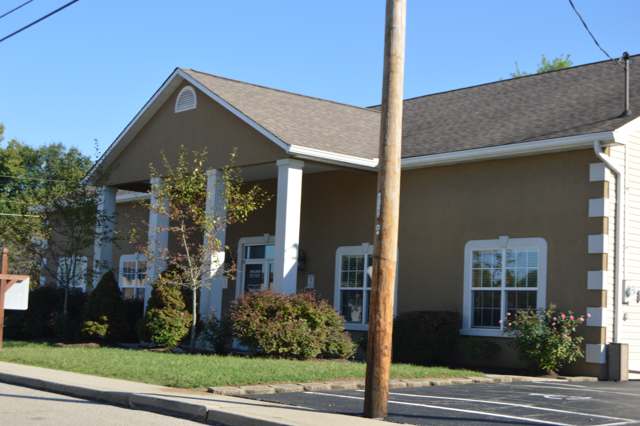
Photo: Nyttend, public domain · Wikimedia Commons
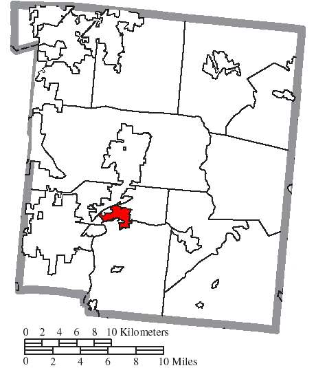
Photo: Wikimedia Commons contributor, public domain · Wikimedia Commons
Local history sources: en.wikipedia.org · warren.ohgenweb.org · warren.ohgenweb.org · hmdb.org · hmdb.org · en.wikipedia.org · en.wikipedia.org · commons.wikimedia.org · commons.wikimedia.org · southlebanonohio.org
Water
Ohio River intake at the plant's riverfront on Kellogg Ave in the California neighborhood, east Cincinnati The water here
- South Lebanon City54% of residentsOhio River (Miller Plant, ~88%) plus Great Miami Buried Valley Aquifer wells (~12%)
- Warren County46% of residentsWells in the Little Miami and Great Miami river valley aquifers
Hospitals, fire stations and more
Inside South Lebanon's boundary: 1 fire or EMS station, 1 public school, 1 museum, 1 Superfund site, 3 Toxics Release Inventory facilities, 3 spill cases and 1 mound or earthwork. Press a pin or a name for its whole record and its source.
Fire and EMS stations (1)
-
Union Township and South Lebanon Fire DepartmentSouth Lebanon
- Address
- 285 East Pike Street, South Lebanon, OH 45065
- Coordinates
- 39.37288, -84.21388
USGS National Map structures (source) ↗ Street map and directions ↗
Source: USGS National Map structures (most Ohio records last updated 2019 to 2022), checked against the Columbus and Cleveland station lists. The department that answers a call is set by jurisdiction and mutual aid, not by distance.
Public schools (1)
-
South Lebanon Elementary SchoolMaineville
- Address
- 50 Ridgeview Ln, Maineville, OH 45039
- Kind (NCES)
- Regular School
- Students, 2023-24
- 535
- Teachers (full-time equivalent)
- 25.75
- NCES school ID
- 390504303945
Source: NCES EDGE public school locations 2024-25 and Common Core of Data 2023-24 (type, students, teachers); Ohio School Report Cards 2025-26 (Department of Education and Workforce), matched by name within the district.
Museums, historical societies, gardens and zoos (1)
-
South Lebanon Historical SocietyHistorical society · South Lebanon
- What it is
- Historical society
- City
- South Lebanon
- Coordinates
- 39.36992, -84.21129
Search Wikipedia ↗ IMLS Museum Data Files (source) ↗ Street map and directions ↗
The museum list is IMLS's 2018 file; a museum may have closed or moved since.
Source: IMLS Museum Data Files, 2018.
Superfund sites (1)
-
Peters Cartridge Factory NPLSuperfund, NPL · Kings Mills
- Address
- 1415 Grandin Road, Kings Mills, OH 45034
- County
- Warren County
- Status
- On the National Priorities List
- EPA program ID
- OHD987051083
- EPA registry ID
- 110009343148
EPA facility record ↗ EPA Facility Registry Service (source) ↗ Street map and directions ↗
Source: EPA Facility Registry Service, Superfund (SEMS) and National Priorities List sites. Many program sites were assessed and needed no cleanup.
Facilities reporting toxic releases (3)
-
Epic Technologies LlcToxics Release Inventory · Lebanon
- Address
- 1151 W Mason-Morrow Rd Suite B, Lebanon, OH 45036
- County
- Warren County
- Status
- Reports to the Toxics Release Inventory (closed)
- EPA program ID
- 45036PCTCH1151W
- EPA registry ID
- 110024942507
EPA facility record ↗ EPA Facility Registry Service (source) ↗ Street map and directions ↗
-
Lens Crafters Kings Mill Technology CenterToxics Release Inventory · Maineville
- Address
- 1413 Grandin Rd., Maineville, OH 45039
- County
- Warren County
- Status
- Reports to the Toxics Release Inventory (active)
- EPA program ID
- 45039LNSCR1413G
- EPA registry ID
- 110002112758
EPA facility record ↗ EPA Facility Registry Service (source) ↗ Street map and directions ↗
-
Mmmilgrove Road LlcToxics Release Inventory · Lebanon
- Address
- 1151 West Mason Morrow Road, Lebanon, OH 45036
- County
- Warren County
- Status
- Reports to the Toxics Release Inventory (active)
- EPA program ID
- 45036CNCNNRT484
- EPA registry ID
- 110000392352
EPA facility record ↗ EPA Facility Registry Service (source) ↗ Street map and directions ↗
Source: EPA Facility Registry Service, Toxics Release Inventory reporters. Reporting a release is required of large users of listed chemicals; it is not by itself a violation.
Spills reported since 2021 (3)
-
Material Blue Reached water2023-09-16 · South Lebanon
- Reported
- 2023-09-16
- What spilled
- Material Blue
- Reached a waterway
- Little Miami River
- Where
- South Lebanon, Warren County
- Ohio EPA district office
- SWDO
- Ohio EPA case number
- 2309EPA0001613
Ohio EPA spill reports (source) ↗ Street map and directions ↗
-
Fuel Diesel / Diesel Fuel (Vehicle On Or Off Road)2026-07-14 · South Lebanon
- Reported
- 2026-07-14
- What spilled
- Fuel Diesel / Diesel Fuel (Vehicle On Or Off Road)
- Where
- South Lebanon, Warren County
- Ohio EPA district office
- ESW
- Ohio EPA case number
- 2607EPA0001283
Ohio EPA spill reports (source) ↗ Street map and directions ↗
-
Fuel Diesel / Diesel Fuel (Vehicle On Or Off Road)2026-04-29 · Lebanon
- Reported
- 2026-04-29
- What spilled
- Fuel Diesel / Diesel Fuel (Vehicle On Or Off Road)
- Largest amount reported
- 60 gallons
- Where
- Lebanon, Warren County
- Ohio EPA district office
- SWDO
- Ohio EPA case number
- 2604EPA0000720
Ohio EPA spill reports (source) ↗ Street map and directions ↗
Source: Ohio EPA emergency response spill reports, 2021 to September 2026, one point per case where Ohio EPA placed it. A report is what the caller or responder recorded; amounts are often blank or estimated.
Mounds and earthworks (1)
-
Moar Mound and Village SiteMound · Late Woodland
- What it is
- Mound
- Also named
- Moar Mound and Village
- Age
- Late Woodland
- Where
- west of Morrow, Hamilton Township
- County
- Warren County
- Named in the history of
- Hamilton Township, Warren County
- Map point
- from the site's Wikipedia article
Wikipedia article (point and source) ↗ Street map and directions ↗
Many mounds stand on private land; visit only those open to the public.
Source: the History records' native sites, each placed by its own Wikipedia article; sites no article places are named on the History card but not pinned.
Its ZIP codes
Each ZIP code that touches South Lebanon, with the share of its residents who live here and the same headline figures as the ZIP page.
| ZIP | Share | Water | Radon | Home value | Schools | Flood |
|---|---|---|---|---|---|---|
| 45065 South Lebanon | 94% | Ohio River intake at the plant's riverfront on Kellogg Ave in the California neighborhood, east Cincinnati | 3.5 pCi/L average radon | Appraisal records without year built | Kings Local · 4.5 stars overall | 7.6% of residents in the 1% floodplain |
Local government
Who holds office in South Lebanon, how its elections and ballot issues came out, and the state auditor's record.
Elections for office
| Date | Office | Candidates and votes |
|---|---|---|
| 2017-11-07 | Member of Council | Linda Burke 421, 18.09%; Bryan C. Corcoran 371, 15.94%; Linda Allen 342, 14.7%; Rolin Spicer 312, 13.41%; Steve Riley 259, 11.13%; Sue Johnson 258, 11.09%; Randall Atkins 224, 9.63%; John Moore 140, 6.02% |
| 2015-11-03 | Member of Council | F. James Boerio 657, 38.69%; William Madison 343, 20.2%; George Teasdale 291, 17.14%; Linda Burke 208, 12.25%; William Harrison 167, 9.84%; INVALID WRITE-INs 32, 1.88% |
| 2015-11-03 | Mayor | James D. Smith 778, 58.76%; Lionel H. Lawhorn 546, 41.24% |
Winners in bold. Results from the county board of elections' official canvass unless marked.
Auditor of State record
- No fiscal caution, watch or emergency on the Auditor of State's lists.
- Financial Audit, 2024, released 2026-01-08
- Financial Audit, 2023, released 2024-09-24
The county
Warren County: 12 ZIP codes, 24 cities, villages and townships, 222,825 people.
Nearby places
Rain and snow
How much has actually fallen on South Lebanon, day by day, from 1893 to now. Daily totals, not averages.
- rain, last 30 days
- 1.02 in
- 2026-09-30 to 2026-10-29
- rain so far in 2026
- 44.7 in
- 5.9 in above normal for the date
- snow so far in 2026
- 17.2 in
- a normal year brings 16.9 in
- a normal year
- 45.6 in
- average of 30 years, 1991-2020
| Month | Rain (in) | Snow (in) | Days counted |
|---|---|---|---|
| October 2026 | 1.02 | — | 29 |
| September 2026 | 7.48 | — | 30 |
| August 2026 | 6.65 | — | 31 |
| July 2026 | 3.49 | — | 31 |
| June 2026 | 4.67 | — | 30 |
| May 2026 | 6.78 | — | 31 |
| April 2026 | 3.96 | — | 30 |
| March 2026 | 7.55 | 0.3 | 31 |
| February 2026 | 1.33 | 4.9 | 28 |
| January 2026 | 1.72 | 12.0 | 31 |
| December 2025 | 2.66 | 11.2 | 31 |
| November 2025 | 3.75 | 2.1 | 30 |
| Wettest year | 1926 — 63.9 in |
|---|---|
| Driest year | 1934 — 21.6 in |
| Snowiest year | 1977 — 52.3 in |
| Wettest day on record | 6 October 1910 — 5.31 in |
| Heaviest snowfall in a day | 23 December 2004 — 12.52 in |
| Deepest snow on the ground | 25 January 1894 — 20.00 in |
Estimated, not measured. No rain gauge has ever stood inside South Lebanon, so every figure here is worked out from the gauges around it - the nearest ones weighted most. Treat them as close estimates rather than readings.
48,634 days of records, 1893-01-01 to 2026-10-29. Source: NOAA NCEI GHCN-Daily, 3,240 gauges in and around Ohio. A day is "gauged" when a gauge standing inside the boundary reported it, and the value is the mean of those gauges. Otherwise it is interpolated by inverse distance from every gauge reporting within 50 miles. Nothing is carried forward, back-filled or smoothed. Against NOAA nClimDiv county monthly precipitation over 136,848 complete county-months (checked 2026-10-31): correlation 0.9515, median absolute difference 0.217 in a month. Built 2026-10-31 from the Cracked Buckeye precipitation archive. Snow is the softer number — snowfall is measured by hand with a ruler, no agency publishes a gridded county snowfall series, and blowing snow defeats every observer.
Environmental permits and filings
What Ohio EPA has on file for South Lebanon: permits, inspections, violations, cleanups and the state loans behind sewer and water work. Every line links to the agency's own document.
- facilities and sites on file
- 18
- those placed on the map inside South Lebanon
Data centers, power and big tech here. Ohio EPA files that name a data-center company, a power plant or substation, or a large technology firm:
- DUKE ENERGY COLUMBIA SUBSTATION EXPANSION (wastewater and stormwater discharge, latest Jan 23, 2025)
| Program | Facilities and sites |
|---|---|
| Wastewater and stormwater discharge | 5 |
| Voluntary cleanup | 4 |
| Air pollution | 2 |
| Hazardous waste | 1 |
| Public drinking water | 1 |
| Scrap tires | 1 |
| Sewer and water-line construction | 1 |
| State sewer loans | 1 |
| State water loans | 1 |
| Wetland and stream fill | 1 |
| Date | Facility or site | What |
|---|---|---|
| SOUTH LEBANON CITY OF PWS | Public drinking water notice of violation | |
| ROGERS PARK | Scrap tires cleanup response | |
| ROGERS PARK | Scrap tires cleanup response | |
| SOUTH LEBANON CITY OF PWS | Public drinking water violation resolved | |
| SOUTH LEBANON CITY OF PWS | Public drinking water report | |
| SOUTH LEBANON CITY OF PWS | Public drinking water compliance letter | |
| SOUTH LEBANON CITY OF PWS | Public drinking water inspection | |
| SOUTH LEBANON CITY OF PWS | Public drinking water notice of violation | |
| ARBORS EAST | Sewer and water-line construction permit | |
| ARBORS EAST | Sewer and water-line construction permit | |
| SOUTH LEBANON CITY OF PWS | Public drinking water plan | |
| LEBANON WWTP | State sewer loans | |
| SOUTH LEBANON CITY OF PWS | Public drinking water inspection | |
| ARBORS EAST | Sewer and water-line construction permit | |
| 19.954 ACRE UNDEVELOPED PROPERTY, SOUTH LEBANON | Voluntary cleanup covenant | |
| LEBANON WWTP | State sewer loans | |
| 19.954 ACRE UNDEVELOPED PROPERTY, SOUTH LEBANON | Voluntary cleanup covenant | |
| 19.954 ACRE UNDEVELOPED PROPERTY, SOUTH LEBANON | Voluntary cleanup covenant | |
| LEBANON WWTP | State sewer loans | |
| MASON MORROW MILLGROVE ROAD IMPROVEMENTS | Wastewater and stormwater discharge permit | |
| 19.954 ACRE UNDEVELOPED PROPERTY, SOUTH LEBANON | Voluntary cleanup covenant | |
| 19.954 ACRE UNDEVELOPED PROPERTY, SOUTH LEBANON | Voluntary cleanup covenant | |
| OEDER SONS SAND & GRAVEL INC | Air pollution permit | |
| LEBANON WWTP | State sewer loans | |
| SOUTH LEBANON CITY OF PWS | Public drinking water plan |
Source: Ohio EPA eDocument portal (edocpub.epa.ohio.gov), indexed 2026-10-14. Facilities are placed on the map from Ohio EPA's own map layers, EPA's Facility Registry, coordinates written in the filings, or a geocoded street address. A permit filed under a private person's name (most are household septic systems) is counted but never named, placed or linked; licenses for individual workers and open-burning notices are left out entirely.
Quick answers
What county is South Lebanon, Ohio in?
South Lebanon is a city in Warren County, Ohio, with 6,388 residents.
When was South Lebanon, Ohio founded?
South Lebanon was settled c. 1795 (as Deerfield); laid out 1802; incorporated October 2021 (city); renamed from Deerfield Village to South Lebanon 1871. Founders on record: Major Benjamin Stites, Benjamin Stites Jr. and John Gano. Source
How did South Lebanon, Ohio get its name?
First known as Deerfield, the seat of Deerfield Township; the post office and then the town were renamed South Lebanon in 1871 for the settlement's position just south of Lebanon, the county seat, after the railroad came through. Source
What ZIP code is South Lebanon, Ohio?
Most of South Lebanon is in ZIP code 45065.
Where does South Lebanon, Ohio get its water?
The main water source for South Lebanon (South Lebanon City): Ohio River intake at the plant's riverfront on Kellogg Ave in the California neighborhood, east Cincinnati.
Cite this page
Cite this page as:
Cracked Buckeye, "South Lebanon, Warren County", https://crackedbuckeye.com/place/south-lebanon/, built 2026-10-31, accessed [date].
How to cite · Report a correction · Built 2026-10-31
