Local events in Seven Mile
Nothing is posted for Seven Mile itself yet; here is what is on within 10 miles. All local events in Seven Mile
Know a calendar we should watch? Send the link
Checked October 20; the events page is refreshed daily.
Notable people from Seven Mile
Ohioans tied to this place, each with a sourced profile. All notable Ohioans
How Seven Mile began
Seven Mile takes its name from Sevenmile Creek, itself a translation of the waterway's earlier name Watamaw, said to mean 'shining water.' Troops encamped on the creek's east bank in October 1791, part of the buildup for General Arthur St. Clair's campaign against the Western Confederacy that ended that November in St. Clair's Defeat. The town itself was laid out on a turnpike in 1841 and incorporated in 1875, and by 1905 it supported a hotel, harness shop, tin shop, meat store, and mill; the village was spared the worst of the Great Dayton Flood of 1913 because an elevated railroad grade separated it from the creek. Around 1900 the village originated a distinctive children's tradition, the 'Rag'n Fads' parade, in which children dressed in their most tattered clothes.
Platted 1841, incorporated 1875, by Laid out on a turnpike in 1841.
Where the name comes from
Seven Mile takes its name from Sevenmile Creek, which flows past the village; the creek in turn carried an earlier name, Watamaw, reported to mean 'shining water.'
Before the town
Sevenmile Creek, which gives the village its name, itself carried an earlier documented name, Watamaw, reported to mean 'shining water' -- one of the few place names in the sources consulted with an attributed Native-language origin, though no source consulted identifies which nation's language the word comes from or gives a fuller etymology. On October 6, 1791, 2,200 troops marched to the area and encamped on the creek's east bank; this was during the buildup to General Arthur St. Clair's campaign against the Western Confederacy of Miami, Shawnee, Lenape, and allied nations, which ended in St. Clair's Defeat that November, the U.S. Army's worst-ever loss to a Native force, fought elsewhere in western Ohio.
Nations recorded here: Miami, Shawnee.
Timeline
- — On October 6, 2,200 troops march to the area and encamp on the east side of Sevenmile Creek, part of the buildup to General Arthur St. Clair's campaign that ended in St. Clair's Defeat that November.
- — Seven Mile is laid out on a turnpike.
- — Seven Mile incorporates as a village.
- — The village originates the 'Rag'n Fads' children's parade, in which participants dress in their most tattered clothing.
- — The village supports a hotel, a harness shop, a tin shop, a meat store, and a mill.
- — Seven Mile is spared the worst damage of the Great Dayton/Great Miami Flood because an elevated railroad grade separates the town from Sevenmile Creek.
- — A medical marijuana dispensary opens in Seven Mile, drawing on the village's central location within a regional service area following Ohio's medical marijuana legalization.
Stories
The railroad grade that held back the flood
When the Great Miami valley's catastrophic flood tore through Butler County in March 1913, devastating Hamilton and Middletown alike, Seven Mile caught a break that owed nothing to planning and everything to an accident of earlier railroad engineering. The rail line running past the village had been built up on an elevated grade separating the town from Sevenmile Creek, and when the creek and the wider Great Miami system rose to their historic 1913 crests, that embankment did double duty as an unintentional levee, keeping the worst of the floodwater out of the village even as neighboring communities along the main river channel were inundated. It was luck rather than foresight, but it meant Seven Mile's own 1905-era hotel, harness shop, tin shop, meat store, and mill came through the disaster that reshaped so much of the rest of the county largely intact.
Dressed in rags for the 'Rag'n Fads'
Sometime around 1900, Seven Mile's children began a tradition unlike anything documented elsewhere in Butler County: a parade called the 'Rag'n Fads,' in which the point was not to dress up but to dress down, with every child turning out in the most tattered, worn-out clothing they owned. In a small farming and mill village where new clothes were an expense most families felt keenly, the parade inverted the usual rules of a small-town celebration, transforming patched overalls and threadbare dresses -- ordinarily something to be a little embarrassed about -- into the whole point of the day. The custom captures something specific about turn-of-the-century Seven Mile: a community small enough, and close enough, that even its own poverty could become the occasion for a shared, cheerful public ritual.
Photographs
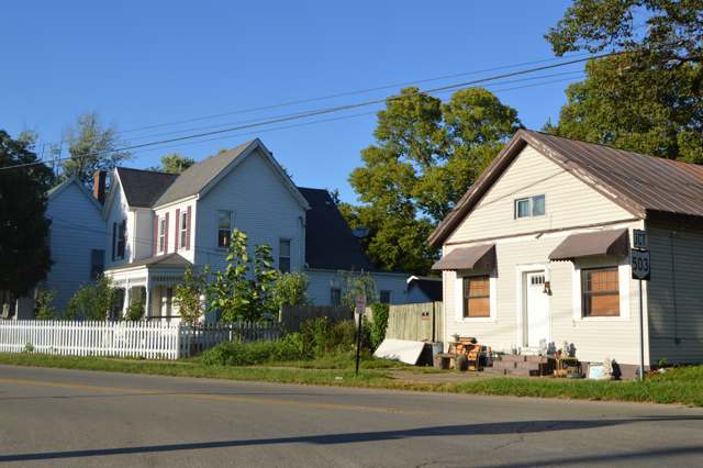
Photo: Nyttend, public domain · Wikimedia Commons
Local history sources: en.wikipedia.org · commons.wikimedia.org
Water
Four wells on a 100-acre district wellfield over the Great Miami valley aquifer, St. Clair Twp, north of Hamilton The water here
- Southwest Regional Water District100% of residentsGreat Miami Buried Valley Aquifer (wells)
Hospitals, fire stations and more
Inside Seven Mile's boundary: 1 fire or EMS station, 1 public school, 1 museum, 1 police station and 1 spill case. Press a pin or a name for its whole record and its source.
Fire and EMS stations (1)
-
Seven Mile Fire Department and Life SquadSeven Mile
- Address
- 201 High Street, Seven Mile, OH 45062
- Coordinates
- 39.48035, -84.55390
USGS National Map structures (source) ↗ Street map and directions ↗
Source: USGS National Map structures (most Ohio records last updated 2019 to 2022), checked against the Columbus and Cleveland station lists. The department that answers a call is set by jurisdiction and mutual aid, not by distance.
Public schools (1)
-
Edgewood Early Childhood Center1 of 5 stars · Seven Mile
- Address
- 200 W Ritter St, Seven Mile, OH 45062
- School district
- Edgewood City School District
- Kind (NCES)
- Regular School
- Students, 2023-24
- 312
- Teachers (full-time equivalent)
- 17.6
- Report card, 2025-26
- 1 of 5 stars
- Ohio building IRN
- 001438
- NCES school ID
- 390460902422
NCES school record ↗ Ohio School Report Card ↗ Street map and directions ↗
Source: NCES EDGE public school locations 2024-25 and Common Core of Data 2023-24 (type, students, teachers); Ohio School Report Cards 2025-26 (Department of Education and Workforce), matched by name within the district.
Museums, historical societies, gardens and zoos (1)
-
Seven Mile Historical SocietyHistorical society · Seven Mile
- What it is
- Historical society
- City
- Seven Mile
- Coordinates
- 39.48189, -84.55373
Search Wikipedia ↗ IMLS Museum Data Files (source) ↗ Street map and directions ↗
The museum list is IMLS's 2018 file; a museum may have closed or moved since.
Source: IMLS Museum Data Files, 2018.
Police stations (1)
-
Seven Mile Village Police DepartmentSeven Mile
- Address
- 201 High Street, Seven Mile, OH 45062
- Coordinates
- 39.48051, -84.55400
USGS National Map structures (source) ↗ Street map and directions ↗
Source: USGS National Map structures, police stations, corrected and completed by hand (September 2026). The department that answers a call is set by jurisdiction, not by distance.
Spills reported since 2021 (1)
-
Oil Hydraulic Fluid(S)2025-06-03 · Seven Mile
- Reported
- 2025-06-03
- What spilled
- Oil Hydraulic Fluid(S)
- Where
- Seven Mile, Butler County
- Ohio EPA district office
- SWDO
- Ohio EPA case number
- 2506EPA0000890
Ohio EPA spill reports (source) ↗ Street map and directions ↗
Source: Ohio EPA emergency response spill reports, 2021 to September 2026, one point per case where Ohio EPA placed it. A report is what the caller or responder recorded; amounts are often blank or estimated.
Its ZIP codes
Each ZIP code that touches Seven Mile, with the share of its residents who live here and the same headline figures as the ZIP page.
| ZIP | Share | Water | Radon | Home value | Schools | Flood |
|---|---|---|---|---|---|---|
| 45062 Seven Mile | 89% | Four wells on a 100-acre district wellfield over the Great Miami valley aquifer, St. Clair Twp, north of Hamilton | 7.6 pCi/L average radon | Median year built 1938 | Edgewood City · 3.5 stars overall | 0.0% of residents in the 1% floodplain |
Local government
Who holds office in Seven Mile, how its elections and ballot issues came out, and the state auditor's record.
Who holds office
| Office | Name | Party | Term ends | Contact |
|---|---|---|---|---|
| Clerk-Treasurer | Garrett Kehr | 11/2/2027 | ||
| Member of Council | Sarah White | 11/2/2027 | ||
| Member of Council | Lara Shalet Askill | 11/2/2027 | ||
| Member of Council | David W. Martin | 11/6/2029 | ||
| Member of Council | Jennifer Miller | 11/6/2029 |
Roster as of 2026-07-27: county board of elections.
Auditor of State record
- No fiscal caution, watch or emergency on the Auditor of State's lists.
- Agreed Upon Procedures, 2023 to 2024, released 2025-07-03
The county
Butler County: 13 ZIP codes, 22 cities, villages and townships, 382,868 people.
Nearby places
Rain and snow
How much has actually fallen on Seven Mile, day by day, from 1893 to now. Daily totals, not averages.
- rain, last 30 days
- 1.01 in
- 2026-09-30 to 2026-10-29
- rain so far in 2026
- 46.2 in
- 9.7 in above normal for the date
- snow so far in 2026
- 15.7 in
- a normal year brings 13.7 in
- a normal year
- 43.1 in
- average of 30 years, 1991-2020
| Month | Rain (in) | Snow (in) | Days counted |
|---|---|---|---|
| October 2026 | 1.01 | — | 29 |
| September 2026 | 5.13 | — | 30 |
| August 2026 | 8.90 | — | 31 |
| July 2026 | 2.55 | — | 31 |
| June 2026 | 5.47 | — | 30 |
| May 2026 | 7.79 | — | 31 |
| April 2026 | 3.87 | — | 30 |
| March 2026 | 8.05 | 0.7 | 31 |
| February 2026 | 1.88 | 3.4 | 28 |
| January 2026 | 1.52 | 11.7 | 31 |
| December 2025 | 2.35 | 10.9 | 31 |
| November 2025 | 3.28 | 1.5 | 30 |
| Wettest year | 2011 — 66.3 in |
|---|---|
| Driest year | 1934 — 23.1 in |
| Snowiest year | 1917 — 47.6 in |
| Wettest day on record | 14 September 1979 — 4.60 in |
| Heaviest snowfall in a day | 15 January 1893 — 12.01 in |
| Deepest snow on the ground | 22 January 1918 — 21.32 in |
Estimated, not measured. No rain gauge has ever stood inside Seven Mile, so every figure here is worked out from the gauges around it - the nearest ones weighted most. Treat them as close estimates rather than readings.
48,166 days of records, 1893-01-01 to 2026-10-29. Source: NOAA NCEI GHCN-Daily, 3,240 gauges in and around Ohio. A day is "gauged" when a gauge standing inside the boundary reported it, and the value is the mean of those gauges. Otherwise it is interpolated by inverse distance from every gauge reporting within 50 miles. Nothing is carried forward, back-filled or smoothed. Against NOAA nClimDiv county monthly precipitation over 136,848 complete county-months (checked 2026-10-31): correlation 0.9515, median absolute difference 0.217 in a month. Built 2026-10-31 from the Cracked Buckeye precipitation archive. Snow is the softer number — snowfall is measured by hand with a ruler, no agency publishes a gridded county snowfall series, and blowing snow defeats every observer.
Environmental permits and filings
What Ohio EPA has on file for Seven Mile: permits, inspections, violations, cleanups and the state loans behind sewer and water work. Every line links to the agency's own document.
- facilities and sites on file
- 6
- those placed on the map inside Seven Mile
| Program | Facilities and sites |
|---|---|
| Site assessment | 3 |
| Air pollution | 2 |
| Public drinking water | 1 |
| Date | Facility or site | What |
|---|---|---|
| SEVEN MILE VILLAGE PWS | Public drinking water report | |
| SEVEN MILE VILLAGE PWS | Public drinking water plan | |
| SEVEN MILE VILLAGE PWS | Public drinking water inspection | |
| SEVEN MILE VILLAGE PWS | Public drinking water inspection | |
| SEVEN MILE VILLAGE PWS | Public drinking water notice of violation | |
| SEVEN MILE VILLAGE PWS | Public drinking water compliance letter | |
| SEVEN MILE VILLAGE PWS | Public drinking water inspection | |
| SEVEN MILE VILLAGE PWS | Public drinking water report | |
| ENCORE PRECAST LLC | Air pollution permit | |
| SEVEN MILE VILLAGE PWS | Public drinking water inspection | |
| SEVEN MILE VILLAGE PWS | Public drinking water compliance letter | |
| SEVEN MILE VILLAGE PWS | Public drinking water inspection | |
| SEVEN MILE VILLAGE PWS | Public drinking water compliance letter | |
| SEVEN MILE VILLAGE PWS | Public drinking water compliance letter | |
| SEVEN MILE VILLAGE PWS | Public drinking water compliance letter | |
| SEVEN MILE VILLAGE PWS | Public drinking water report | |
| SEVEN MILE VILLAGE PWS | Public drinking water compliance letter | |
| SEVEN MILE VILLAGE PWS | Public drinking water permit | |
| SEVEN MILE VILLAGE PWS | Public drinking water report | |
| SEVEN MILE VILLAGE PWS | Public drinking water compliance letter | |
| SEVEN MILE VILLAGE PWS | Public drinking water notice of violation | |
| SEVEN MILE VILLAGE PWS | Public drinking water report | |
| ENCORE PRECAST LLC | Air pollution permit | |
| SEVEN MILE VILLAGE PWS | Public drinking water inspection | |
| SEVEN MILE VILLAGE PWS | Public drinking water compliance letter |
Source: Ohio EPA eDocument portal (edocpub.epa.ohio.gov), indexed 2026-10-14. Facilities are placed on the map from Ohio EPA's own map layers, EPA's Facility Registry, coordinates written in the filings, or a geocoded street address. A permit filed under a private person's name (most are household septic systems) is counted but never named, placed or linked; licenses for individual workers and open-burning notices are left out entirely.
Quick answers
What county is Seven Mile, Ohio in?
Seven Mile is a village in Butler County, Ohio, with 712 residents.
When was Seven Mile, Ohio founded?
Seven Mile was laid out 1841; incorporated 1875. Founders on record: Laid out on a turnpike in 1841. Source
How did Seven Mile, Ohio get its name?
Seven Mile takes its name from Sevenmile Creek, which flows past the village; the creek in turn carried an earlier name, Watamaw, reported to mean 'shining water.' Source
What ZIP code is Seven Mile, Ohio?
Most of Seven Mile is in ZIP code 45062.
Where does Seven Mile, Ohio get its water?
The main water source for Seven Mile (Southwest Regional Water District): Four wells on a 100-acre district wellfield over the Great Miami valley aquifer, St. Clair Twp, north of Hamilton.
Cite this page
Cite this page as:
Cracked Buckeye, "Seven Mile, Butler County", https://crackedbuckeye.com/place/seven-mile/, built 2026-10-31, accessed [date].
How to cite · Report a correction · Built 2026-10-31
