Local events in Sandusky
32 events in the next 90 days from 6 public calendars. All local events in Sandusky
Checked October 20; the events page is refreshed daily.
Lakes near Sandusky
The history under the water: the valley before, the dam, the stories. All Ohio lakes
Deep dives about Sandusky
Long reads built from maps, newspapers and public records. All deep dives
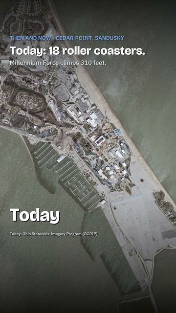
- Cedar PointCedar Point became a resort in 1870 when Louis Zistel ferried Sandusky residents across the bay. George A. Boeckling opened the Hotel Breakers in 1905.
- Ohio State FairThe Ohio State Fair began in Cincinnati in 1850, moved among ten Ohio cities, then settled in 1886 on the Columbus fairgrounds it still uses.
History from Sandusky
People and inventions tied to this place, each with its sources. All people · All inventions
Videos about Sandusky
Short videos we made from the old maps and records. All videos
How Sandusky began
Sandusky was founded in 1818 on the southeast shore of Sandusky Bay, absorbing an earlier small settlement called Portland that dated to about 1816, and was incorporated as a city in 1824; it became the seat of newly formed Erie County in 1838. Its name comes from the Wyandot word for water or cold water (rendered "saundustee"), a name French traders had already attached to the bay by 1718, and local tradition holds the city itself rose on ground once occupied by a Wyandot man remembered as Ogontz. Rail lines, lake shipping, limestone quarrying, ice harvesting and a mild lakeshore climate that suited grape growing built a 19th-century city that by 1880 held 16,000 people, twenty churches and three newspapers; the beach resort that opened on the Cedar Point peninsula in 1870 grew, over the next century and a half, into one of the country's best-known amusement parks. Today Sandusky is Erie County's largest city and a Lake Erie tourism hub built around Cedar Point and the Lake Erie islands ferries.
Settled 1816 (as Portland), platted 1818, incorporated 1824, by European American settlers who absorbed the earlier Portland settlement.
Where the name comes from
Sandusky takes its name from the Wyandot word rendered "saundustee" or "andusti," meaning water or cold water; French maps as early as 1718 already labeled the bay "Lac Sandouske," and the Jesuit historian Charlevoix transliterated the name as "Chinouski" in his 1734 history of New France -- so the name predates the American city by a century.
Before the town
Sandusky Bay was a center of Wyandot life and of European trade and fortification for more than a century before the American city was platted. Pennsylvania traders built an English trading post on the north side of the bay around 1745 under a grant from the Wyandot leader Orontony (called Nicolas by the French); the French replaced it about 1749-50 with Fort Sandoske, and in 1761 the British general Jeffery Amherst ordered a new Fort Sandusky built nearby to help secure the Great Lakes after the French and Indian War. On May 16, 1763, during Pontiac's War, a party of Wyandot gained entry to that fort under the pretense of holding a council, then killed the fifteen-man garrison and the traders present and burned the post after looting it -- one of the opening blows of the uprising. Local tradition, repeated in the city's own history, holds that the American townsite itself was built on ground known as the home of a Wyandot man remembered as Ogontz, giving rise to the phrase that Sandusky was built on "Ogontz's place"; the financier Jay Cooke, born in Sandusky in 1821, later named his own Pennsylvania estate "Ogontz" after this local association. The Wyandot village long associated with the region, called Upper Sandusky, lay well upriver in what is now Wyandot County, outside Erie County. The 1805 Treaty of Fort Industry opened the wider Firelands region to settlement.
Nations recorded here: Wyandot.
- Fort Sandoske / Fort Sandusky (English 1745, French c.1749-53, British 1761) (other) — southeast shore of Sandusky Bay, present Erie County, near the site of the later American city, 1745-1763 (en.wikipedia.org)
- Ogontz's place (village) — site of downtown Sandusky, before 1818 (tradition) (en.wikipedia.org)
Timeline
- — Pennsylvania traders built an English trading post on the north side of Sandusky Bay under permission from the Wyandot leader Orontony.
- — British general Jeffery Amherst ordered Fort Sandusky built on the bay to strengthen British defenses after the French and Indian War.
- — Wyandot warriors entered Fort Sandusky under a pretext of council during Pontiac's War, killed the garrison and burned the fort.
- — An early settlement called Portland was established on the future townsite.
- — Sandusky was founded/platted by American settlers, absorbing Portland.
- — Financier Jay Cooke was born in Sandusky, son of pioneer Ohio lawyer and congressman Eleutheros Cooke.
- — Sandusky was incorporated as a city.
- — Ground was broken for the Mad River and Lake Erie Railroad, one of Ohio's earliest rail lines, bringing rapid change to the town.
- — Erie County was formed and Sandusky was designated the county seat.
- — English author Charles Dickens visited Sandusky and described it in his travelogue American Notes.
- — German immigrant Louis Zistel began ferrying visitors to the Cedar Point peninsula and opened a public bathing beach, bathhouse and beer garden -- the start of what became Cedar Point amusement park.
- — Sandusky's population reached about 16,000, with twenty churches, three newspapers and 29 businesses employing at least ten workers, producing lime, locomotives, carriages, beer, paper and tools.
- — A Grand Pavilion with a two-story theater, concert hall and bowling alley opened at Cedar Point.
- — The Switchback Railway, Cedar Point's first roller coaster, opened.
- — The steamer G.A. Boeckling began carrying passengers between Sandusky and Cedar Point.
Stories
The banker who named his mansion for a Wyandot neighbor
Jay Cooke was born in Sandusky on August 10, 1821, the son of Eleutheros Cooke, a pioneer Ohio lawyer who served in the state legislature and, from 1831 to 1833, in Congress. The younger Cooke left for Philadelphia in 1838, and by 1861 he had opened his own banking house, Jay Cooke & Company; during the Civil War he pioneered mass-marketing techniques to sell government war bonds directly to ordinary citizens, moving roughly $500 million in "five-twenty" bonds and then $830 million in "seven-thirty" notes between February and July of 1865 -- financing that helped keep the Union war effort solvent. Cooke's firm later overreached backing the Northern Pacific Railway, and its collapse touched off the Panic of 1873, one of the worst financial crises of the 19th century. Decades after leaving the Sandusky Bay shore where he grew up, Cooke named his grand Pennsylvania estate near Philadelphia "Ogontz," after the Wyandot man local tradition held had lived on the ground where Sandusky itself was later built -- carrying a piece of his hometown's Native history into a Gilded Age mansion, and later into the name of the Philadelphia neighborhood that grew up around it.
A beer garden becomes Cedar Point
In 1870, German immigrant Louis Zistel began ferrying Sandusky-area residents out to the wooded Cedar Point peninsula, opened it as a public bathing beach, and built a bathhouse and a small beer garden with a dance floor, charging 25 cents for the boat ride. Other operators followed: James West added bathhouses in 1878, and in 1882 Benjamin Dwelle and Captain William Slackford leased land and built eight more bathhouses, a dance hall and boardwalks. After Slackford fell ill in 1888, Dwelle brought in new partners -- Adam Stoll, Louis Adolph, Charles Baetz and Jacob Kuebeler -- who built a Grand Pavilion with a theater, concert hall and bowling alley the same year. The peninsula got its first thrill ride, a water toboggan, in 1890, and its first roller coaster, the 25-foot Switchback Railway, in 1892; by 1908 the steamer G.A. Boeckling was hauling passengers across the bay from downtown Sandusky. What began as one immigrant's beer-garden ferry service was, within a generation, a full lake resort, and the amusement park it grew into is now one of the oldest continuously operating in the United States.
Photographs
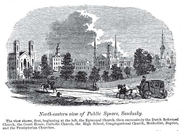
Photo: John W. Barber and Henry Howe, 1865, public domain · Wikimedia Commons
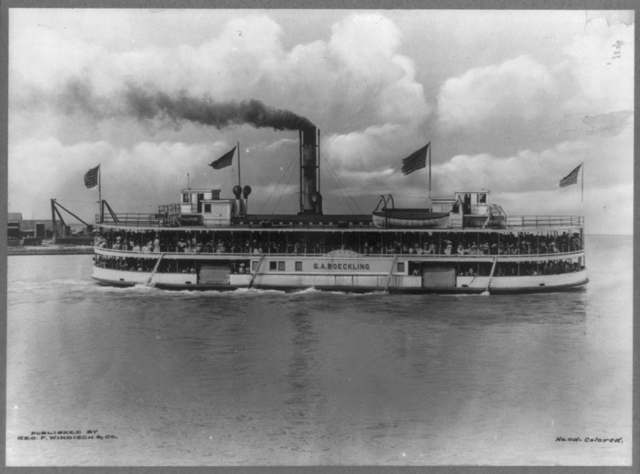
Photo: Library of Congress, Prints and Photographs Division, public domain · Wikimedia Commons
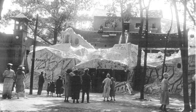
Photo: Rudolph Gartner, Toledo Lucas County Public Library, via DPLA, public domain · Wikimedia Commons
Local history sources: en.wikipedia.org · en.wikipedia.org · en.wikipedia.org · en.wikipedia.org · commons.wikimedia.org · commons.wikimedia.org · commons.wikimedia.org
Historic places
111 places in Sandusky on the National Register of Historic Places. Press a pin or a name for its whole record.
-
Adams Street Double HouseBuilding · Sandusky · listed 1975
- Address
- 106--108 E. Adams St.
- Where
- Sandusky, Erie County · ZIP 44870
- What it is
- Building
- Listed on the National Register
- 1975
- NRIS reference number
- 75001384
- Coordinates
- 41.45364, -82.70979
National Register file (NPS) ↗ Search Wikipedia ↗ Street map and directions ↗ On the Cracked Buckeye map
-
Barker SchoolBuilding · Sandusky · listed 1982
- Address
- 1925 Barker St.
- Where
- Sandusky, Erie County · ZIP 44870
- What it is
- Building
- Listed on the National Register
- 1982
- NRIS reference number
- 82001374
- Coordinates
- 41.44528, -82.72705
National Register file (NPS) ↗ Search Wikipedia ↗ Street map and directions ↗ On the Cracked Buckeye map
-
Barney, Freeland T., HouseBuilding · Sandusky · listed 1982
- Address
- 215-213 Fulton St.
- Where
- Sandusky, Erie County · ZIP 44870
- What it is
- Building
- Listed on the National Register
- 1982
- NRIS reference number
- 82001375
- Coordinates
- 41.45391, -82.71602
National Register file (NPS) ↗ Search Wikipedia ↗ Street map and directions ↗ On the Cracked Buckeye map
-
Bates-Cockrem HouseBuilding · Sandusky · listed 1982
- Address
- 325 Lawrence St.
- Where
- Sandusky, Erie County · ZIP 44870
- What it is
- Building
- Listed on the National Register
- 1982
- NRIS reference number
- 82001376
- Coordinates
- 41.45182, -82.71692
National Register file (NPS) ↗ Search Wikipedia ↗ Street map and directions ↗ On the Cracked Buckeye map
-
Bavarian BreweryBuilding · Sandusky · listed 1982
- Address
- 1816-1820 W. Jefferson St.
- Where
- Sandusky, Erie County · ZIP 44870
- What it is
- Building
- Listed on the National Register
- 1982
- NRIS reference number
- 82001377
- Coordinates
- 41.44927, -82.72512
National Register file (NPS) ↗ Search Wikipedia ↗ Street map and directions ↗ On the Cracked Buckeye map
-
Beecher, Lucas, HouseBuilding · Sandusky · listed 1979
- Address
- 215 W. Washington Row
- Where
- Sandusky, Erie County · ZIP 44870
- What it is
- Building
- Listed on the National Register
- 1979
- NRIS reference number
- 79001827
- Coordinates
- 41.45504, -82.71258
National Register file (NPS) ↗ Search Wikipedia ↗ Street map and directions ↗ On the Cracked Buckeye map
-
Bing's HotelBuilding · Sandusky · listed 1982
- Address
- 302 E. Water St.
- Where
- Sandusky, Erie County · ZIP 44870
- What it is
- Building
- Listed on the National Register
- 1982
- NRIS reference number
- 82001378
- Coordinates
- 41.45825, -82.70871
National Register file (NPS) ↗ Search Wikipedia ↗ Street map and directions ↗ On the Cracked Buckeye map
-
Boalt, John, HouseBuilding · Sandusky · listed 1982
- Address
- 631 Wayne St.
- Where
- Sandusky, Erie County · ZIP 44870
- What it is
- Building
- Listed on the National Register
- 1982
- NRIS reference number
- 82001379
- Coordinates
- 41.44909, -82.70656
National Register file (NPS) ↗ Search Wikipedia ↗ Street map and directions ↗ On the Cracked Buckeye map
-
Boeckling BuildingBuilding · Sandusky · listed 1982
- Address
- 103-105 W. Shoreline Dr.
- Where
- Sandusky, Erie County · ZIP 44870
- What it is
- Building
- Listed on the National Register
- 1982
- NRIS reference number
- 82001380
- Coordinates
- 41.45756, -82.71277
National Register file (NPS) ↗ Search Wikipedia ↗ Street map and directions ↗ On the Cracked Buckeye map
-
Boeckling, G. A., HouseBuilding · Sandusky · listed 1983
- Address
- 614 Columbus Ave.
- Where
- Sandusky, Erie County · ZIP 44870
- What it is
- Building
- Listed on the National Register
- 1983
- NRIS reference number
- 83001960
- Coordinates
- 41.45078, -82.70816
National Register file (NPS) ↗ Search Wikipedia ↗ Street map and directions ↗ On the Cracked Buckeye map
-
Boy with the Boot FountainObject · Sandusky · listed 1982
- Address
- W. Washington St. Park
- Where
- Sandusky, Erie County · ZIP 44870
- What it is
- Object
- Listed on the National Register
- 1982
- NRIS reference number
- 82001381
- Coordinates
- 41.45440, -82.71280
National Register file (NPS) ↗ Search Wikipedia ↗ Street map and directions ↗ On the Cracked Buckeye map
-
Cable, Frank, HouseBuilding · Sandusky · listed 1982
- Address
- 809 W. Washington St.
- Where
- Sandusky, Erie County · ZIP 44870
- What it is
- Building
- Listed on the National Register
- 1982
- NRIS reference number
- 82001382
- Coordinates
- 41.45299, -82.71684
National Register file (NPS) ↗ Search Wikipedia ↗ Street map and directions ↗ On the Cracked Buckeye map
-
Cable, Laurence HouseBuilding · Sandusky · listed 1982
- Address
- 910 W. Monroe St.
- Where
- Sandusky, Erie County · ZIP 44870
- What it is
- Building
- Listed on the National Register
- 1982
- NRIS reference number
- 82001383
- Coordinates
- 41.44762, -82.71454
National Register file (NPS) ↗ Search Wikipedia ↗ Street map and directions ↗ On the Cracked Buckeye map
-
Campbell SchoolBuilding · Sandusky · listed 1982
- Address
- 1215 Campbell St.
- Where
- Sandusky, Erie County · ZIP 44870
- What it is
- Building
- Listed on the National Register
- 1982
- NRIS reference number
- 82001384
- Coordinates
- 41.44530, -82.70729
National Register file (NPS) ↗ Search Wikipedia ↗ Street map and directions ↗ On the Cracked Buckeye map
-
Carnegie LibraryBuilding · Sandusky · listed 1975
- Address
- Adams and Columbus Ave.
- Where
- Sandusky, Erie County · ZIP 44870
- What it is
- Building
- Listed on the National Register
- 1975
- NRIS reference number
- 75001385
- Coordinates
- 41.45318, -82.71026
National Register file (NPS) ↗ Search Wikipedia ↗ Street map and directions ↗ On the Cracked Buckeye map
-
Cedar Point LightBuilding · Sandusky · listed 1984
- Address
- Cedar Point
- Where
- Sandusky, Erie County · ZIP 44870
- What it is
- Building
- Listed on the National Register
- 1984
- NRIS reference number
- 84003667
- Coordinates
- 41.48802, -82.69344
National Register file (NPS) ↗ Search Wikipedia ↗ Street map and directions ↗ On the Cracked Buckeye map
-
ColiseumBuilding · Sandusky · listed 1982
- Address
- Midway at Cedar Point
- Where
- Sandusky, Erie County · ZIP 44870
- What it is
- Building
- Listed on the National Register
- 1982
- NRIS reference number
- 82001385
- Coordinates
- 41.48135, -82.68153
National Register file (NPS) ↗ Search Wikipedia ↗ Street map and directions ↗ On the Cracked Buckeye map
-
Commercial Banking & Trust Co.Building · Sandusky · listed 1982
- Address
- 115 E. Washington Row
- Where
- Sandusky, Erie County · ZIP 44870
- What it is
- Building
- Listed on the National Register
- 1982
- NRIS reference number
- 82001386
- Coordinates
- 41.45533, -82.71091
National Register file (NPS) ↗ Search Wikipedia ↗ Street map and directions ↗ On the Cracked Buckeye map
-
Converse-Mertz ApartmentsBuilding · Sandusky · listed 1982
- Address
- 301-303 E. Washington St.
- Where
- Sandusky, Erie County · ZIP 44870
- What it is
- Building
- Listed on the National Register
- 1982
- NRIS reference number
- 82001388
- Coordinates
- 41.45620, -82.70746
National Register file (NPS) ↗ Search Wikipedia ↗ Street map and directions ↗ On the Cracked Buckeye map
-
Cooke, Eleutheros, HouseBuilding · Sandusky · listed 1982
- Address
- 1415 Columbus Ave.
- Where
- Sandusky, Erie County · ZIP 44870
- What it is
- Building
- Listed on the National Register
- 1982
- NRIS reference number
- 82001389
- Coordinates
- 41.44398, -82.70487
National Register file (NPS) ↗ Search Wikipedia ↗ Street map and directions ↗ On the Cracked Buckeye map
-
Cooke, Eleutheros, HouseBuilding · Sandusky · listed 1982
- Address
- 410 Columbus Ave.
- Where
- Sandusky, Erie County · ZIP 44870
- What it is
- Building
- Listed on the National Register
- 1982
- NRIS reference number
- 82001390
- Coordinates
- 41.45328, -82.70990
National Register file (NPS) ↗ Search Wikipedia ↗ Street map and directions ↗ On the Cracked Buckeye map
-
Cooke-Robertson HouseBuilding · Sandusky · listed 1982
- Address
- 412 Columbus Ave.
- Where
- Sandusky, Erie County · ZIP 44870
- What it is
- Building
- Listed on the National Register
- 1982
- NRIS reference number
- 82001387
- Coordinates
- 41.45310, -82.70977
National Register file (NPS) ↗ Search Wikipedia ↗ Street map and directions ↗ On the Cracked Buckeye map
-
Curtis, William D., HouseBuilding · Sandusky · listed 1982
- Address
- 1411 Hayes Ave.
- Where
- Sandusky, Erie County · ZIP 44870
- What it is
- Building
- Listed on the National Register
- 1982
- NRIS reference number
- 82001391
- Coordinates
- 41.44327, -82.71035
National Register file (NPS) ↗ Search Wikipedia ↗ Street map and directions ↗ On the Cracked Buckeye map
-
Dentzel, William H., 1921 CarouselStructure · Sandusky · listed 1990
- Address
- Frontiertown, Cedar Point Amusement Park
- Where
- Sandusky, Erie County · ZIP 44870
- What it is
- Structure
- Listed on the National Register
- 1990
- NRIS reference number
- 90000627
- Coordinates
- 41.48546, -82.69318
National Register file (NPS) ↗ Search Wikipedia ↗ Street map and directions ↗ On the Cracked Buckeye map
-
Dentzel, William H., 1924 CarouselStructure · Sandusky · listed 1990
- Address
- Kiddieland, Cedar Point Amusement Park
- Where
- Sandusky, Erie County · ZIP 44870
- What it is
- Structure
- Listed on the National Register
- 1990
- NRIS reference number
- 90000625
- Coordinates
- 41.48067, -82.68108
National Register file (NPS) ↗ Search Wikipedia ↗ Street map and directions ↗ On the Cracked Buckeye map
-
Doerzbach, George J., HouseBuilding · Sandusky · listed 1987
- Address
- 1208--1210 Central Ave.
- Where
- Sandusky, Erie County · ZIP 44870
- What it is
- Building
- Listed on the National Register
- 1987
- NRIS reference number
- 87000639
- Coordinates
- 41.44520, -82.71400
National Register file (NPS) ↗ Search Wikipedia ↗ Street map and directions ↗ On the Cracked Buckeye map
-
Emmanuel ChurchBuilding · Sandusky · listed 1982
- Address
- 334 Columbus Ave.
- Where
- Sandusky, Erie County · ZIP 44870
- What it is
- Building
- Listed on the National Register
- 1982
- NRIS reference number
- 82001392
- Coordinates
- 41.45390, -82.71015
National Register file (NPS) ↗ Search Wikipedia ↗ Street map and directions ↗ On the Cracked Buckeye map
-
Engels And Krudwig Wine Company BuildingsBuilding · Sandusky · listed 1976
- Address
- 220 E. Water St.
- Where
- Sandusky, Erie County · ZIP 44870
- What it is
- Building
- Listed on the National Register
- 1976
- NRIS reference number
- 76001417
- Coordinates
- 41.45788, -82.70954
National Register file (NPS) ↗ Search Wikipedia ↗ Street map and directions ↗ On the Cracked Buckeye map
-
Engels, Herman, HouseBuilding · Sandusky · listed 1982
- Address
- 117 Hancock St.
- Where
- Sandusky, Erie County · ZIP 44870
- What it is
- Building
- Listed on the National Register
- 1982
- NRIS reference number
- 82001393
- Coordinates
- 41.45762, -82.70870
National Register file (NPS) ↗ Search Wikipedia ↗ Street map and directions ↗ On the Cracked Buckeye map
-
Engine House No. 1Building · Sandusky · listed 1982
- Address
- 901 W. Market St.
- Where
- Sandusky, Erie County · ZIP 44870
- What it is
- Building
- Listed on the National Register
- 1982
- NRIS reference number
- 82001394
- Coordinates
- 41.45404, -82.71938
National Register file (NPS) ↗ Search Wikipedia ↗ Street map and directions ↗ On the Cracked Buckeye map
-
Engine House No. 3Building · Sandusky · listed 1975
- Address
- Meigs St. and Sycamore Line
- Where
- Sandusky, Erie County · ZIP 44870
- What it is
- Building
- Listed on the National Register
- 1975
- NRIS reference number
- 75001386
- Coordinates
- 41.45264, -82.69803
National Register file (NPS) ↗ Search Wikipedia ↗ Street map and directions ↗ On the Cracked Buckeye map
-
Erie County JailBuilding · Sandusky · listed 1982
- Address
- 204 W. Adams St.
- Where
- Sandusky, Erie County · ZIP 44870
- What it is
- Building
- Listed on the National Register
- 1982
- NRIS reference number
- 82001395
- Coordinates
- 41.45344, -82.71086
National Register file (NPS) ↗ Search Wikipedia ↗ Street map and directions ↗ On the Cracked Buckeye map
-
Erie County Office BuildingBuilding · Sandusky · listed 1974
- Address
- 1202 Sycamore Line
- Where
- Sandusky, Erie County · ZIP 44870
- What it is
- Building
- Listed on the National Register
- 1974
- NRIS reference number
- 74001470
- Coordinates
- 41.44761, -82.69718
National Register file (NPS) ↗ Search Wikipedia ↗ Street map and directions ↗ On the Cracked Buckeye map
-
Erie County Oil Products Co.Building · Sandusky · listed 1982
- Address
- 649 Tiffin Ave.
- Where
- Sandusky, Erie County · ZIP 44870
- What it is
- Building
- Listed on the National Register
- 1982
- NRIS reference number
- 82001396
- Coordinates
- 41.44636, -82.75066
National Register file (NPS) ↗ Search Wikipedia ↗ Street map and directions ↗ On the Cracked Buckeye map
-
Exchange HotelBuilding · Sandusky
- Address
- 202--204 E. Water St.
- Where
- Sandusky, Erie County · ZIP 44870
- What it is
- Building
- Latest NPS certification action
- 1985
- NRIS reference number
- 75001388
- Coordinates
- 41.45769, -82.71013
National Register file (NPS) ↗ Search Wikipedia ↗ Street map and directions ↗ On the Cracked Buckeye map
-
Facer's StoreBuilding · Sandusky · listed 1982
- Address
- 279 E. Market St.
- Where
- Sandusky, Erie County · ZIP 44870
- What it is
- Building
- Listed on the National Register
- 1982
- NRIS reference number
- 82001397
- Coordinates
- 41.45717, -82.70856
National Register file (NPS) ↗ Search Wikipedia ↗ Street map and directions ↗ On the Cracked Buckeye map
-
Feick BuildingBuilding · Sandusky · listed 2009
- Address
- 158-160 E. Market St.
- Where
- Sandusky, Erie County · ZIP 44870
- What it is
- Building
- Listed on the National Register
- 2009
- NRIS reference number
- 09000848
- Coordinates
- 41.45633, -82.71034
National Register file (NPS) ↗ Search Wikipedia ↗ Street map and directions ↗ On the Cracked Buckeye map
-
First Church of Christ ScientistBuilding · Sandusky · listed 1982
- Address
- 128 E. Adams St.
- Where
- Sandusky, Erie County · ZIP 44870
- What it is
- Building
- Listed on the National Register
- 1982
- NRIS reference number
- 82001398
- Coordinates
- 41.45383, -82.70896
National Register file (NPS) ↗ Search Wikipedia ↗ Street map and directions ↗ On the Cracked Buckeye map
-
First Congregational ChurchBuilding · Sandusky · listed 1982
- Address
- 431 Columbus Ave.
- Where
- Sandusky, Erie County · ZIP 44870
- What it is
- Building
- Listed on the National Register
- 1982
- NRIS reference number
- 82001399
- Coordinates
- 41.45247, -82.70988
National Register file (NPS) ↗ Search Wikipedia ↗ Street map and directions ↗ On the Cracked Buckeye map
-
Follett-Moss-Moss ResidencesBuilding · Sandusky · listed 1974
- Address
- 404, 414, 428 Wayne St.
- Where
- Sandusky, Erie County · ZIP 44870
- What it is
- Building
- Listed on the National Register
- 1974
- NRIS reference number
- 74001471
- Coordinates
- 41.45376, -82.70776
National Register file (NPS) ↗ Search Wikipedia ↗ Street map and directions ↗ On the Cracked Buckeye map
-
Fox's Brewery-Diamond Wine Co.Building · Sandusky · listed 1982
- Address
- 334 Harrison St.
- Where
- Sandusky, Erie County · ZIP 44870
- What it is
- Building
- Listed on the National Register
- 1982
- NRIS reference number
- 82001400
- Coordinates
- 41.45117, -82.72445
National Register file (NPS) ↗ Search Wikipedia ↗ Street map and directions ↗ On the Cracked Buckeye map
-
Godfrey-Johnson HouseBuilding · Sandusky · listed 1982
- Address
- 417 Columbus Ave.
- Where
- Sandusky, Erie County · ZIP 44870
- What it is
- Building
- Listed on the National Register
- 1982
- NRIS reference number
- 82001401
- Coordinates
- 41.45292, -82.71001
National Register file (NPS) ↗ Search Wikipedia ↗ Street map and directions ↗ On the Cracked Buckeye map
-
Grace Episcopal ChurchBuilding · Sandusky · listed 1982
- Address
- 315 Wayne St.
- Where
- Sandusky, Erie County · ZIP 44870
- What it is
- Building
- Listed on the National Register
- 1982
- NRIS reference number
- 82001402
- Coordinates
- 41.45482, -82.70934
National Register file (NPS) ↗ Search Wikipedia ↗ Street map and directions ↗ On the Cracked Buckeye map
-
Graefe, Henry, HouseBuilding · Sandusky · listed 1982
- Address
- 1429 Columbus Ave.
- Where
- Sandusky, Erie County · ZIP 44870
- What it is
- Building
- Listed on the National Register
- 1982
- NRIS reference number
- 82001403
- Coordinates
- 41.44354, -82.70462
National Register file (NPS) ↗ Search Wikipedia ↗ Street map and directions ↗ On the Cracked Buckeye map
-
Great American Racing DerbyStructure · Sandusky · listed 1990
- Address
- Midway, Cedar Point Amusement Park
- Where
- Sandusky, Erie County · ZIP 44870
- What it is
- Structure
- Listed on the National Register
- 1990
- NRIS reference number
- 90000626
- Coordinates
- 41.48065, -82.68252
National Register file (NPS) ↗ Search Wikipedia ↗ Street map and directions ↗ On the Cracked Buckeye map
-
Harper, Rice, HouseBuilding · Sandusky · listed 1982
- Address
- 403 E. Washington St.
- Where
- Sandusky, Erie County · ZIP 44870
- What it is
- Building
- Listed on the National Register
- 1982
- NRIS reference number
- 82001404
- Coordinates
- 41.45685, -82.70580
National Register file (NPS) ↗ Search Wikipedia ↗ Street map and directions ↗ On the Cracked Buckeye map
-
Hemminger SaloonBuilding · Sandusky · listed 1982
- Address
- 333 W. Market St.
- Where
- Sandusky, Erie County · ZIP 44870
- What it is
- Building
- Listed on the National Register
- 1982
- NRIS reference number
- 82001405
- Coordinates
- 41.45538, -82.71391
National Register file (NPS) ↗ Search Wikipedia ↗ Street map and directions ↗ On the Cracked Buckeye map
-
Hinde & Dauch Paper Co.Building · Sandusky · listed 1982
- Address
- 409 W. Water St.
- Where
- Sandusky, Erie County · ZIP 44870
- What it is
- Building
- Listed on the National Register
- 1982
- NRIS reference number
- 82001406
- Coordinates
- 41.45626, -82.71525
National Register file (NPS) ↗ Search Wikipedia ↗ Street map and directions ↗ On the Cracked Buckeye map
-
Hinde & Dauch Paper Co.Building · Sandusky · listed 1982
- Address
- 401 W. Shoreline Dr.
- Where
- Sandusky, Erie County · ZIP 44870
- What it is
- Building
- Listed on the National Register
- 1982
- NRIS reference number
- 82001407
- Coordinates
- 41.45797, -82.71505
National Register file (NPS) ↗ Search Wikipedia ↗ Street map and directions ↗ On the Cracked Buckeye map
-
Hinde & Dauch Paper Co.Building · Sandusky · listed 1982
- Address
- 407 Decatur St.
- Where
- Sandusky, Erie County · ZIP 44870
- What it is
- Building
- Listed on the National Register
- 1982
- NRIS reference number
- 82001408
- Coordinates
- 41.45224, -82.71322
National Register file (NPS) ↗ Search Wikipedia ↗ Street map and directions ↗ On the Cracked Buckeye map
-
Hinde, James J., HouseBuilding · Sandusky · listed 1982
- Address
- 317 Fulton St.
- Where
- Sandusky, Erie County · ZIP 44870
- What it is
- Building
- Listed on the National Register
- 1982
- NRIS reference number
- 82001409
- Coordinates
- 41.45230, -82.71514
National Register file (NPS) ↗ Search Wikipedia ↗ Street map and directions ↗ On the Cracked Buckeye map
-
Holy Angels ChurchBuilding · Sandusky · listed 1982
- Address
- W. Jefferson St. at Tiffin Ave. and Clinton St.
- Where
- Sandusky, Erie County · ZIP 44870
- What it is
- Building
- Listed on the National Register
- 1982
- NRIS reference number
- 82001410
- Coordinates
- 41.44930, -82.72296
National Register file (NPS) ↗ Search Wikipedia ↗ Street map and directions ↗ On the Cracked Buckeye map
-
Hotel RiegerBuilding · Sandusky · listed 2005
- Address
- 232 Jackson St.
- Where
- Sandusky, Erie County · ZIP 44870
- What it is
- Building
- Listed on the National Register
- 2005
- NRIS reference number
- 05000578
- Coordinates
- 41.45540, -82.71301
National Register file (NPS) ↗ Search Wikipedia ↗ Street map and directions ↗ On the Cracked Buckeye map
-
Hubbard, Lester, HouseBuilding · Sandusky · listed 1982
- Address
- 134 E. Adams St.
- Where
- Sandusky, Erie County · ZIP 44870
- What it is
- Building
- Listed on the National Register
- 1982
- NRIS reference number
- 82001411
- Coordinates
- 41.45393, -82.70860
National Register file (NPS) ↗ Search Wikipedia ↗ Street map and directions ↗ On the Cracked Buckeye map
-
Hubbard, S. B., HouseBuilding · Sandusky · listed 1982
- Address
- 1205 Columbus Ave.
- Where
- Sandusky, Erie County · ZIP 44870
- What it is
- Building
- Listed on the National Register
- 1982
- NRIS reference number
- 82001412
- Coordinates
- 41.44577, -82.70575
National Register file (NPS) ↗ Search Wikipedia ↗ Street map and directions ↗ On the Cracked Buckeye map
-
Independent Order of Odd Fellows TempleBuilding · Sandusky · listed 2003
- Address
- 231 W. Washington Row
- Where
- Sandusky, Erie County · ZIP 44870
- What it is
- Building
- Listed on the National Register
- 2003
- NRIS reference number
- 03000327
- Coordinates
- 41.45495, -82.71270
National Register file (NPS) ↗ Search Wikipedia ↗ Street map and directions ↗ On the Cracked Buckeye map
-
Jackson Jr. High SchoolBuilding · Sandusky · listed 1982
- Address
- 414 W. Madison St.
- Where
- Sandusky, Erie County · ZIP 44870
- What it is
- Building
- Listed on the National Register
- 1982
- NRIS reference number
- 82001413
- Coordinates
- 41.45004, -82.70945
National Register file (NPS) ↗ Search Wikipedia ↗ Street map and directions ↗ On the Cracked Buckeye map
-
Kerber's Marine GroceryBuilding · Sandusky · listed 1982
- Address
- 1006 Tiffin Ave.
- Where
- Sandusky, Erie County · ZIP 44870
- What it is
- Building
- Listed on the National Register
- 1982
- NRIS reference number
- 82001414
- Coordinates
- 41.44609, -82.72671
National Register file (NPS) ↗ Search Wikipedia ↗ Street map and directions ↗ On the Cracked Buckeye map
-
Kuebeler, August, HouseBuilding · Sandusky · listed 1982
- Address
- 1319 Tiffin Ave.
- Where
- Sandusky, Erie County · ZIP 44870
- What it is
- Building
- Listed on the National Register
- 1982
- NRIS reference number
- 82001416
- Coordinates
- 41.44425, -82.72929
National Register file (NPS) ↗ Search Wikipedia ↗ Street map and directions ↗ On the Cracked Buckeye map
-
Kuebeler-Stang BlockBuilding · Sandusky · listed 1982
- Address
- 634 Hancock St.
- Where
- Sandusky, Erie County · ZIP 44870
- What it is
- Building
- Listed on the National Register
- 1982
- NRIS reference number
- 82001415
- Coordinates
- 41.45137, -82.70470
National Register file (NPS) ↗ Search Wikipedia ↗ Street map and directions ↗ On the Cracked Buckeye map
-
Lake Shore And Michigan Southern Railroad DepotBuilding · Sandusky · listed 1975
- Address
- N. Depot at Carr St.
- Where
- Sandusky, Erie County · ZIP 44870
- What it is
- Building
- Listed on the National Register
- 1975
- NRIS reference number
- 75001389
- Coordinates
- 41.44063, -82.71842
National Register file (NPS) ↗ Search Wikipedia ↗ Street map and directions ↗ On the Cracked Buckeye map
-
Lane, Ebenezer, HouseBuilding · Sandusky · listed 1982
- Address
- 318 Huron Ave.
- Where
- Sandusky, Erie County · ZIP 44870
- What it is
- Building
- Listed on the National Register
- 1982
- NRIS reference number
- 82001417
- Coordinates
- 41.45501, -82.70863
National Register file (NPS) ↗ Search Wikipedia ↗ Street map and directions ↗ On the Cracked Buckeye map
-
Lea BlockBuilding · Sandusky · listed 1982
- Address
- 174-186 E. Market St.
- Where
- Sandusky, Erie County · ZIP 44870
- What it is
- Building
- Listed on the National Register
- 1982
- NRIS reference number
- 82001418
- Coordinates
- 41.45634, -82.70986
National Register file (NPS) ↗ Search Wikipedia ↗ Street map and directions ↗ On the Cracked Buckeye map
-
Lotz, Henry, StoneBuilding · Sandusky · listed 1982
- Address
- 1119 W. Washington St.
- Where
- Sandusky, Erie County · ZIP 44870
- What it is
- Building
- Listed on the National Register
- 1982
- NRIS reference number
- 82001419
- Coordinates
- 41.45177, -82.72016
National Register file (NPS) ↗ Search Wikipedia ↗ Street map and directions ↗ On the Cracked Buckeye map
-
Mad River BlockBuilding · Sandusky · listed 1974
- Address
- 1002-1018 W. Adams St.
- Where
- Sandusky, Erie County · ZIP 44870
- What it is
- Building
- Listed on the National Register
- 1974
- NRIS reference number
- 74001472
- Coordinates
- 41.45054, -82.71833
National Register file (NPS) ↗ Search Wikipedia ↗ Street map and directions ↗ On the Cracked Buckeye map
-
Mallory, Ogden, HouseBuilding · Sandusky · listed 1982
- Address
- 410 Warren St.
- Where
- Sandusky, Erie County · ZIP 44870
- What it is
- Building
- Listed on the National Register
- 1982
- NRIS reference number
- 82001420
- Coordinates
- 41.45544, -82.70349
National Register file (NPS) ↗ Search Wikipedia ↗ Street map and directions ↗ On the Cracked Buckeye map
-
March, George, HouseBuilding · Sandusky · listed 1982
- Address
- 532 Wayne St.
- Where
- Sandusky, Erie County · ZIP 44870
- What it is
- Building
- Listed on the National Register
- 1982
- NRIS reference number
- 82001421
- Coordinates
- 41.45197, -82.70675
National Register file (NPS) ↗ Search Wikipedia ↗ Street map and directions ↗ On the Cracked Buckeye map
-
Marshall, James E., HouseBuilding · Sandusky · listed 1982
- Address
- 514 Wayne St.
- Where
- Sandusky, Erie County · ZIP 44870
- What it is
- Building
- Listed on the National Register
- 1982
- NRIS reference number
- 82001422
- Coordinates
- 41.45242, -82.70700
National Register file (NPS) ↗ Search Wikipedia ↗ Street map and directions ↗ On the Cracked Buckeye map
-
McKenster-Groff HouseBuilding · Sandusky · listed 1982
- Address
- 334 E. Washington St.
- Where
- Sandusky, Erie County · ZIP 44870
- What it is
- Building
- Listed on the National Register
- 1982
- NRIS reference number
- 82001423
- Coordinates
- 41.45630, -82.70627
National Register file (NPS) ↗ Search Wikipedia ↗ Street map and directions ↗ On the Cracked Buckeye map
-
Melville-Milne, William Gordon, HouseBuilding · Sandusky · listed 1979
- Address
- 319 Lawrence St.
- Where
- Sandusky, Erie County · ZIP 44870
- What it is
- Building
- Listed on the National Register
- 1979
- NRIS reference number
- 79001828
- Coordinates
- 41.45200, -82.71705
National Register file (NPS) ↗ Search Wikipedia ↗ Street map and directions ↗ On the Cracked Buckeye map
-
Mertz, John, HouseBuilding · Sandusky · listed 1992
- Address
- 610 W. Washington St.
- Where
- Sandusky, Erie County · ZIP 44870
- What it is
- Building
- Listed on the National Register
- 1992
- NRIS reference number
- 92001077
- Coordinates
- 41.45326, -82.71696
National Register file (NPS) ↗ Search Wikipedia ↗ Street map and directions ↗ On the Cracked Buckeye map
-
Monroe SchoolBuilding · Sandusky · listed 1982
- Address
- 328 E. Monroe St.
- Where
- Sandusky, Erie County · ZIP 44870
- What it is
- Building
- Listed on the National Register
- 1982
- NRIS reference number
- 82001424
- Coordinates
- 41.45139, -82.70350
National Register file (NPS) ↗ Search Wikipedia ↗ Street map and directions ↗ On the Cracked Buckeye map
-
Moss-Foster HouseBuilding · Sandusky · listed 1982
- Address
- 621 Wayne St.
- Where
- Sandusky, Erie County · ZIP 44870
- What it is
- Building
- Listed on the National Register
- 1982
- NRIS reference number
- 82001425
- Coordinates
- 41.45098, -82.70673
National Register file (NPS) ↗ Search Wikipedia ↗ Street map and directions ↗ On the Cracked Buckeye map
-
Muller, Daniel C., CarouselSite · Sandusky · listed 1982
- Address
- Midway at Cedar Point
- Where
- Sandusky, Erie County · ZIP 44870
- What it is
- Site
- Listed on the National Register
- 1982
- NRIS reference number
- 82001426
- Coordinates
- 41.48070, -82.68247
National Register file (NPS) ↗ Search Wikipedia ↗ Street map and directions ↗ On the Cracked Buckeye map
-
Murschel HouseBuilding · Sandusky · listed 1982
- Address
- 1221 N. Depot St.
- Where
- Sandusky, Erie County · ZIP 44870
- What it is
- Building
- Listed on the National Register
- 1982
- NRIS reference number
- 82001427
- Coordinates
- 41.44073, -82.71807
National Register file (NPS) ↗ Search Wikipedia ↗ Street map and directions ↗ On the Cracked Buckeye map
-
No. 5 Fire StationBuilding · Sandusky · listed 1982
- Address
- W. Madison and Tiffin Ave.
- Where
- Sandusky, Erie County · ZIP 44870
- What it is
- Building
- Listed on the National Register
- 1982
- NRIS reference number
- 82001428
- Coordinates
- 41.44517, -82.72824
National Register file (NPS) ↗ Search Wikipedia ↗ Street map and directions ↗ On the Cracked Buckeye map
-
Old First ChurchBuilding · Sandusky · listed 1982
- Address
- 265 Jackson St.
- Where
- Sandusky, Erie County · ZIP 44870
- What it is
- Building
- Listed on the National Register
- 1982
- NRIS reference number
- 82001430
- Coordinates
- 41.45431, -82.71280
National Register file (NPS) ↗ Search Wikipedia ↗ Street map and directions ↗ On the Cracked Buckeye map
-
Osborne SchoolBuilding · Sandusky · listed 1982
- Address
- 922 W. Osborne St.
- Where
- Sandusky, Erie County · ZIP 44870
- What it is
- Building
- Listed on the National Register
- 1982
- NRIS reference number
- 82001431
- Coordinates
- 41.44176, -82.71510
National Register file (NPS) ↗ Search Wikipedia ↗ Street map and directions ↗ On the Cracked Buckeye map
-
Red Popcorn WagonBuilding · Sandusky · listed 1982
- Address
- 102 W. Washington Row
- Where
- Sandusky, Erie County · ZIP 44870
- What it is
- Building
- Listed on the National Register
- 1982
- NRIS reference number
- 82001432
- Coordinates
- 41.45506, -82.71114
National Register file (NPS) ↗ Search Wikipedia ↗ Street map and directions ↗ On the Cracked Buckeye map
-
Root, Joseph, HouseBuilding · Sandusky · listed 1982
- Address
- 231 E. Adams St.
- Where
- Sandusky, Erie County · ZIP 44870
- What it is
- Building
- Listed on the National Register
- 1982
- NRIS reference number
- 82001433
- Coordinates
- 41.45493, -82.70755
National Register file (NPS) ↗ Search Wikipedia ↗ Street map and directions ↗ On the Cracked Buckeye map
-
Ross HardwareBuilding · Sandusky · listed 1982
- Address
- 708 Hancock St.
- Where
- Sandusky, Erie County · ZIP 44870
- What it is
- Building
- Listed on the National Register
- 1982
- NRIS reference number
- 82001434
- Coordinates
- 41.45092, -82.70469
National Register file (NPS) ↗ Search Wikipedia ↗ Street map and directions ↗ On the Cracked Buckeye map
-
Schine State TheatreBuilding · Sandusky · listed 1982
- Address
- 101-109 Columbus Ave.
- Where
- Sandusky, Erie County · ZIP 44870
- What it is
- Building
- Listed on the National Register
- 1982
- NRIS reference number
- 82001435
- Coordinates
- 41.45691, -82.71274
National Register file (NPS) ↗ Search Wikipedia ↗ Street map and directions ↗ On the Cracked Buckeye map
-
Second Baptist ChurchBuilding · Sandusky · listed 2002
- Address
- 315 Decatur St.
- Where
- Sandusky, Erie County · ZIP 44870
- What it is
- Building
- Listed on the National Register
- 2002
- NRIS reference number
- 02000061
- Coordinates
- 41.45330, -82.71421
National Register file (NPS) ↗ Search Wikipedia ↗ Street map and directions ↗ On the Cracked Buckeye map
-
Simpson, Walter, HouseBuilding · Sandusky · listed 1982
- Address
- 521 Hancock St.
- Where
- Sandusky, Erie County · ZIP 44870
- What it is
- Building
- Listed on the National Register
- 1982
- NRIS reference number
- 82001436
- Coordinates
- 41.45270, -82.70605
National Register file (NPS) ↗ Search Wikipedia ↗ Street map and directions ↗ On the Cracked Buckeye map
-
Simpson, William A., HouseBuilding · Sandusky · listed 1982
- Address
- 230 E. Washington St.
- Where
- Sandusky, Erie County · ZIP 44870
- What it is
- Building
- Listed on the National Register
- 1982
- NRIS reference number
- 82001437
- Coordinates
- 41.45583, -82.70805
National Register file (NPS) ↗ Search Wikipedia ↗ Street map and directions ↗ On the Cracked Buckeye map
-
Sloane, Rush R., HouseBuilding · Sandusky · listed 1975
- Address
- 403 E. Adams St.
- Where
- Sandusky, Erie County · ZIP 44870
- What it is
- Building
- Listed on the National Register
- 1975
- NRIS reference number
- 75001390
- Coordinates
- 41.45551, -82.70541
National Register file (NPS) ↗ Search Wikipedia ↗ Street map and directions ↗ On the Cracked Buckeye map
-
St. Mary's Catholic ChurchBuilding · Sandusky · listed 1975
- Address
- 429 Central Ave.
- Where
- Sandusky, Erie County · ZIP 44870
- What it is
- Building
- Listed on the National Register
- 1975
- NRIS reference number
- 75001391
- Coordinates
- 41.45133, -82.71380
National Register file (NPS) ↗ Search Wikipedia ↗ Street map and directions ↗ On the Cracked Buckeye map
-
St. Mary's Girls Grade SchoolBuilding · Sandusky · listed 1982
- Address
- 514 Decatur St.
- Where
- Sandusky, Erie County · ZIP 44870
- What it is
- Building
- Listed on the National Register
- 1982
- NRIS reference number
- 82001438
- Coordinates
- 41.45091, -82.72384
National Register file (NPS) ↗ Search Wikipedia ↗ Street map and directions ↗ On the Cracked Buckeye map
-
St. Mary's RectoryBuilding · Sandusky · listed 1982
- Address
- 429 Central Ave.
- Where
- Sandusky, Erie County · ZIP 44870
- What it is
- Building
- Listed on the National Register
- 1982
- NRIS reference number
- 82001439
- Coordinates
- 41.45160, -82.71345
National Register file (NPS) ↗ Search Wikipedia ↗ Street map and directions ↗ On the Cracked Buckeye map
-
St. Mary's SchoolBuilding · Sandusky · listed 1982
- Address
- 410 W. Jefferson St.
- Where
- Sandusky, Erie County · ZIP 44870
- What it is
- Building
- Listed on the National Register
- 1982
- NRIS reference number
- 82001440
- Coordinates
- 41.45136, -82.72362
National Register file (NPS) ↗ Search Wikipedia ↗ Street map and directions ↗ On the Cracked Buckeye map
-
St.Stephens' AME ChurchBuilding · Sandusky · listed 1982
- Address
- 312 Neil St.
- Where
- Sandusky, Erie County · ZIP 44870
- What it is
- Building
- Listed on the National Register
- 1982
- NRIS reference number
- 82001441
- Coordinates
- 41.45797, -82.70320
National Register file (NPS) ↗ Search Wikipedia ↗ Street map and directions ↗ On the Cracked Buckeye map
-
Stang, John, HouseBuilding · Sandusky · listed 1982
- Address
- 629 Columbus Ave.
- Where
- Sandusky, Erie County · ZIP 44870
- What it is
- Building
- Listed on the National Register
- 1982
- NRIS reference number
- 82001442
- Coordinates
- 41.45015, -82.70838
National Register file (NPS) ↗ Search Wikipedia ↗ Street map and directions ↗ On the Cracked Buckeye map
-
Stoffel, Henry, Blacksmith ShopBuilding · Sandusky · listed 1982
- Address
- 321 E. Market St. (Rear)
- Where
- Sandusky, Erie County · ZIP 44870
- What it is
- Building
- Listed on the National Register
- 1982
- NRIS reference number
- 82001443
- Coordinates
- 41.45773, -82.70738
National Register file (NPS) ↗ Search Wikipedia ↗ Street map and directions ↗ On the Cracked Buckeye map
-
Stoll, Adam J., HouseBuilding · Sandusky · listed 1982
- Address
- 531 Wayne St.
- Where
- Sandusky, Erie County · ZIP 44870
- What it is
- Building
- Listed on the National Register
- 1982
- NRIS reference number
- 82001444
- Coordinates
- 41.45187, -82.70735
National Register file (NPS) ↗ Search Wikipedia ↗ Street map and directions ↗ On the Cracked Buckeye map
-
Stone's BlockBuilding · Sandusky · listed 1982
- Address
- 202 Columbus Ave.
- Where
- Sandusky, Erie County · ZIP 44870
- What it is
- Building
- Listed on the National Register
- 1982
- NRIS reference number
- 82001445
- Coordinates
- 41.45596, -82.71129
National Register file (NPS) ↗ Search Wikipedia ↗ Street map and directions ↗ On the Cracked Buckeye map
-
Sts. Peter & Paul Church and RectoryBuilding · Sandusky · listed 1983
- Address
- Columbus Ave. at E. Jefferson St.
- Where
- Sandusky, Erie County · ZIP 44870
- What it is
- Building
- Listed on the National Register
- 1983
- NRIS reference number
- 83001963
- Coordinates
- 41.45230, -82.70880
National Register file (NPS) ↗ Search Wikipedia ↗ Street map and directions ↗ On the Cracked Buckeye map
-
Sycamore SchoolBuilding · Sandusky · listed 1974
- Address
- 3rd and Sycamore Sts.
- Where
- Sandusky, Erie County · ZIP 44870
- What it is
- Building
- Listed on the National Register
- 1974
- NRIS reference number
- 74001473
- Coordinates
- 41.45085, -82.69738
National Register file (NPS) ↗ Search Wikipedia ↗ Street map and directions ↗ On the Cracked Buckeye map
-
Taylor-Frohman HouseBuilding · Sandusky · listed 1982
- Address
- 1315 Columbus Ave.
- Where
- Sandusky, Erie County · ZIP 44870
- What it is
- Building
- Listed on the National Register
- 1982
- NRIS reference number
- 82001446
- Coordinates
- 41.44461, -82.70500
National Register file (NPS) ↗ Search Wikipedia ↗ Street map and directions ↗ On the Cracked Buckeye map
-
Third National BankBuilding · Sandusky · listed 1982
- Address
- 220 W. Market St.
- Where
- Sandusky, Erie County · ZIP 44870
- What it is
- Building
- Listed on the National Register
- 1982
- NRIS reference number
- 82001447
- Coordinates
- 41.45549, -82.71259
National Register file (NPS) ↗ Search Wikipedia ↗ Street map and directions ↗ On the Cracked Buckeye map
-
Townsend, William T., HouseBuilding · Sandusky · listed 1982
- Address
- 515 W. Washington St.
- Where
- Sandusky, Erie County · ZIP 44870
- What it is
- Building
- Listed on the National Register
- 1982
- NRIS reference number
- 82001448
- Coordinates
- 41.45375, -82.71458
National Register file (NPS) ↗ Search Wikipedia ↗ Street map and directions ↗ On the Cracked Buckeye map
-
U.S. Coast Guard BuildingBuilding · Sandusky · listed 1982
- Address
- Cedar Point, Off Perimeter Rd.
- Where
- Sandusky, Erie County · ZIP 44870
- What it is
- Building
- Listed on the National Register
- 1982
- NRIS reference number
- 82001449
- Coordinates
- 41.48819, -82.69381
National Register file (NPS) ↗ Search Wikipedia ↗ Street map and directions ↗ On the Cracked Buckeye map
-
U.S. Post OfficeBuilding · Sandusky · listed 1982
- Address
- W. Washington & Jackson Sts.
- Where
- Sandusky, Erie County · ZIP 44870
- What it is
- Building
- Listed on the National Register
- 1982
- NRIS reference number
- 82001450
- Coordinates
- 41.45403, -82.71280
National Register file (NPS) ↗ Search Wikipedia ↗ Street map and directions ↗ On the Cracked Buckeye map
-
Von Schulenburg, Ernst, HouseBuilding · Sandusky · listed 1982
- Address
- 922 W. Adams St.
- Where
- Sandusky, Erie County · ZIP 44870
- What it is
- Building
- Listed on the National Register
- 1982
- NRIS reference number
- 82001451
- Coordinates
- 41.45110, -82.71726
National Register file (NPS) ↗ Search Wikipedia ↗ Street map and directions ↗ On the Cracked Buckeye map
-
Wadsworth, James, HouseBuilding · Sandusky · listed 1982
- Address
- 519 Huron Ave.
- Where
- Sandusky, Erie County · ZIP 44870
- What it is
- Building
- Listed on the National Register
- 1982
- NRIS reference number
- 82001452
- Coordinates
- 41.45326, -82.70475
National Register file (NPS) ↗ Search Wikipedia ↗ Street map and directions ↗ On the Cracked Buckeye map
-
Wagner PalaceBuilding · Sandusky · listed 1982
- Address
- 804-806 Hayes Ave.
- Where
- Sandusky, Erie County · ZIP 44870
- What it is
- Building
- Listed on the National Register
- 1982
- NRIS reference number
- 82001453
- Coordinates
- 41.44845, -82.70726
National Register file (NPS) ↗ Search Wikipedia ↗ Street map and directions ↗ On the Cracked Buckeye map
-
Water Street Commercial BuildingsHistoric district · Sandusky · listed 1975
- Address
- 101--165 E. Water St. and 101--231 W. Water St.
- Where
- Sandusky, Erie County · ZIP 44870
- What it is
- Historic district
- Listed on the National Register
- 1975
- NRIS reference number
- 75001392
- Coordinates
- 41.45738, -82.71240
National Register file (NPS) ↗ Search Wikipedia ↗ Street map and directions ↗ On the Cracked Buckeye map
-
West Market SchoolBuilding · Sandusky · listed 1982
- Address
- 211 Fulton St.
- Where
- Sandusky, Erie County · ZIP 44870
- What it is
- Building
- Listed on the National Register
- 1982
- NRIS reference number
- 82001454
- Coordinates
- 41.45408, -82.71627
National Register file (NPS) ↗ Search Wikipedia ↗ Street map and directions ↗ On the Cracked Buckeye map
-
White, Samuel M., HouseBuilding · Sandusky · listed 1976
- Address
- 304 E. Adams St.
- Where
- Sandusky, Erie County · ZIP 44870
- What it is
- Building
- Listed on the National Register
- 1976
- NRIS reference number
- 76001419
- Coordinates
- 41.45468, -82.70670
National Register file (NPS) ↗ Search Wikipedia ↗ Street map and directions ↗ On the Cracked Buckeye map
-
Wichman's GroceryBuilding · Sandusky · listed 1982
- Address
- 1118 W. Washington St.
- Where
- Sandusky, Erie County · ZIP 44870
- What it is
- Building
- Listed on the National Register
- 1982
- NRIS reference number
- 82001455
- Coordinates
- 41.45159, -82.72039
National Register file (NPS) ↗ Search Wikipedia ↗ Street map and directions ↗ On the Cracked Buckeye map
-
Willdred FlatsBuilding · Sandusky · listed 1993
- Address
- 1116 Columbus Ave.
- Where
- Sandusky, Erie County · ZIP 44870
- What it is
- Building
- Listed on the National Register
- 1993
- NRIS reference number
- 93000152
- Coordinates
- 41.44614, -82.70516
National Register file (NPS) ↗ Search Wikipedia ↗ Street map and directions ↗ On the Cracked Buckeye map
-
Zion Lutheran ChurchBuilding · Sandusky · listed 1982
- Address
- 501-503 Columbus Ave.
- Where
- Sandusky, Erie County · ZIP 44870
- What it is
- Building
- Listed on the National Register
- 1982
- NRIS reference number
- 82001456
- Coordinates
- 41.45202, -82.70975
National Register file (NPS) ↗ Search Wikipedia ↗ Street map and directions ↗ On the Cracked Buckeye map
Source: National Park Service, National Register of Historic Places point file. The listing year is shown where NPS's certification date agrees with the listing's reference number. Listing recognizes significance; it does not restrict a private owner.
Water
Lake Erie, drawn through a 42-inch gravity pipe about three-quarters of a mile offshore near Cedar Point Chaussee, with a Sandusky Bay intake used as backup The water here
- Sandusky City62% of residentsLake Erie (Sandusky Bay backup intake)
- Erie Co. Perkins District33% of residentsLake Erie (Sandusky Bay backup intake)
- Erie Co. Margaretta District5% of residentsLake Erie (Sandusky Bay backup intake)
Hospitals, fire stations and more
Inside Sandusky's boundary: 1 hospital, 9 health centers, 1 dialysis center, 1 nursing home, 3 fire and EMS stations, 2 colleges, 6 public schools, 1 private school, 1 library, 6 museums, 1 police station, 1 public charging site, 1 Superfund site, 16 Toxics Release Inventory facilities, 2 stations and terminals and 32 spill cases. Press a pin or a name for its whole record and its source.
Hospitals (1)
-
Firelands Regional Medical Center Trauma level IIIGeneral hospital · Sandusky
- What it is
- General hospital
- Address
- 1111 Hayes Avenue, Sandusky, OH 44870
- County
- Erie County
- Beds
- 287
- Trauma center
- Level IIi
- Helipad
- Yes
- Ownership
- Non-profit
- Medicare overall rating
- 4 of 5 stars
- Emergency department (Medicare)
- Yes
- Phone
- (419) 557-7400
- Medicare ID
- 360025
Medicare Care Compare ↗ Hospital's website ↗ Where HIFLD got this record ↗ HIFLD hospitals (source) ↗ Street map and directions ↗
Source: HIFLD hospitals inventory via FEMA (closed hospitals it still lists left out, hospitals opened since added), with Medicare Care Compare ratings matched by name and address.
Community health centers (9)
-
ECCHC @ Sandusky Career CenterHealth center · Sandusky
- Run by
- a federally qualified health center
- Setting
- Clinic
- City
- Sandusky
- Coordinates
- 41.43483, -82.71206
Find a Health Center (HRSA) ↗ HRSA data (source) ↗ Street map and directions ↗
-
Erie County Health DepartmentHealth center · Sandusky
- Run by
- a federally qualified health center
- Setting
- Clinic
- City
- Sandusky
- Coordinates
- 41.44870, -82.74341
Find a Health Center (HRSA) ↗ HRSA data (source) ↗ Street map and directions ↗
-
Erie County Job & Family ServicesHealth center · Sandusky
- Run by
- a federally qualified health center
- Setting
- Clinic
- City
- Sandusky
- Coordinates
- 41.43567, -82.70277
Find a Health Center (HRSA) ↗ HRSA data (source) ↗ Street map and directions ↗
-
Family Health Services - Medical CenterHealth center · Sandusky
- Run by
- a federally qualified health center
- Setting
- Clinic
- City
- Sandusky
- Coordinates
- 41.45780, -82.71132
Find a Health Center (HRSA) ↗ HRSA data (source) ↗ Street map and directions ↗
-
Family Health Services Medical CenterHealth center · Sandusky
- Run by
- a federally qualified health center
- Setting
- Clinic
- City
- Sandusky
- Coordinates
- 41.45780, -82.71132
Find a Health Center (HRSA) ↗ HRSA data (source) ↗ Street map and directions ↗
-
Family Health Services of Erie CountyHealth center · Sandusky
- Run by
- a federally qualified health center
- Setting
- Clinic
- City
- Sandusky
- Coordinates
- 41.43719, -82.71189
Find a Health Center (HRSA) ↗ HRSA data (source) ↗ Street map and directions ↗
-
FHS - Water StreetHealth center · Sandusky
- Run by
- a federally qualified health center
- Setting
- Clinic
- City
- Sandusky
- Coordinates
- 41.46025, -82.70428
Find a Health Center (HRSA) ↗ HRSA data (source) ↗ Street map and directions ↗
-
FHS @ Sandusky SELAHealth center · Sandusky
- Run by
- a federally qualified health center
- Setting
- Hospital
- City
- Sandusky
- Coordinates
- 41.43561, -82.69570
Find a Health Center (HRSA) ↗ HRSA data (source) ↗ Street map and directions ↗
-
FHS Behavioral Health - Hayes AvenueHealth center · Sandusky
- Run by
- a federally qualified health center
- Setting
- Clinic
- City
- Sandusky
- Coordinates
- 41.43719, -82.71189
Find a Health Center (HRSA) ↗ HRSA data (source) ↗ Street map and directions ↗
Source: HRSA health center service delivery sites, active, September 2026 (school-based sites left out). Health centers see patients whether or not they have insurance, with fees on a sliding scale.
Dialysis centers (1)
-
Firelands Dialysis Center SouthDialysis · Sandusky
- Address
- 904 Pierce Street, Sandusky, OH 44870
- Dialysis stations
- 31
- Medicare star rating
- 3 of 5 stars
- Services
- in-center hemodialysis
- Ownership
- nonprofit
- Chain
- independent
- Medicare certified since
- 1978-09-15
- Phone
- (419) 557-7228
- Medicare ID
- 362322
Medicare Care Compare ↗ CMS dialysis facility list (source) ↗ Street map and directions ↗
Source: CMS dialysis facility list, September 2026, geocoded with the Census Bureau batch geocoder (an address it could not place sits at its ZIP center).
Nursing homes (1)
-
Providence Care Center1 of 5 stars · Sandusky
- Address
- 2025 Hayes Avenue, Sandusky, OH 44870
- Certified beds
- 138
- Residents on an average day
- 94
- Medicare overall rating
- 1 of 5 stars
- Health inspections
- 1 of 5 stars
- Staffing
- 1 of 5 stars
- Quality measures
- 4 of 5 stars
- Penalties since 2023
- none
- Ownership
- Non profit - Church related
- Chain
- COMMONSPIRIT HEALTH
- Takes
- Medicare and Medicaid
- Phone
- (419) 627-2273
- Medicare ID
- 365976
Medicare Care Compare ↗ CMS nursing home data (source) ↗ Street map and directions ↗
Source: CMS Care Compare nursing home provider and penalties files; Medicare star ratings run 1 to 5.
Fire and EMS stations (3)
-
Sandusky Fire Department Station 1Sandusky
- Address
- 600 West Market Street, Sandusky, OH 44870
- Coordinates
- 41.45459, -82.71562
USGS National Map structures (source) ↗ Street map and directions ↗
-
Sandusky Fire Department Station 3Sandusky
- Address
- 2034 5th Street, Sandusky, OH 44870
- Coordinates
- 41.44675, -82.67826
USGS National Map structures (source) ↗ Street map and directions ↗
-
Sandusky Fire Department Station 7Sandusky
- Address
- 3816 Venice Road, Sandusky, OH 44870
- Coordinates
- 41.44161, -82.75465
USGS National Map structures (source) ↗ Street map and directions ↗
Source: USGS National Map structures (most Ohio records last updated 2019 to 2022), checked against the Columbus and Cleveland station lists. The department that answers a call is set by jurisdiction and mutual aid, not by distance.
Colleges (2)
-
Firelands Regional Medical Center School of NursingPrivate nonprofit two-year college · Sandusky
- What it is
- Private nonprofit two-year college
- City
- Sandusky
- Students, 2023-24 (12-month count)
- 73
- IPEDS unit ID
- 205090
College Navigator (NCES) ↗ IPEDS data (source) ↗ Street map and directions ↗
-
Sandusky Career CenterPublic career school · Sandusky
- What it is
- Public career school
- City
- Sandusky
- Students, 2023-24 (12-month count)
- 175
- IPEDS unit ID
- 383330
College Navigator (NCES) ↗ IPEDS data (source) ↗ Street map and directions ↗
Source: NCES IPEDS 2024 directory, 2023-24 enrollment and tuition, graduation rates for the 2017 (four-year) and 2020 (two-year) entering classes.
Public schools (6)
-
Monroe Preparatory AcademySandusky
- Address
- 328 E Monroe St, Sandusky, OH 44870
- Kind (NCES)
- Regular School
- Students, 2023-24
- 190
- Teachers (full-time equivalent)
- 9
- NCES school ID
- 390059405085
-
Sandusky High School2.5 of 5 stars · Sandusky
- Address
- 2130A Hayes Ave, Sandusky, OH 44870
- School district
- Sandusky City School District
- Kind (NCES)
- Regular School
- Students, 2023-24
- 994
- Teachers (full-time equivalent)
- 55.9
- Report card, 2025-26
- 2.5 of 5 stars
- Performance index
- 60%
- Four-year graduation rate
- 91.3%
- Ohio building IRN
- 033555
- NCES school ID
- 390447401605
NCES school record ↗ Ohio School Report Card ↗ Street map and directions ↗
-
Sandusky Middle School3.5 of 5 stars · Sandusky
- Address
- 2130 Hayes Ave # B, Sandusky, OH 44870
- School district
- Sandusky City School District
- Kind (NCES)
- Regular School
- Students, 2023-24
- 451
- Teachers (full-time equivalent)
- 27
- Report card, 2025-26
- 3.5 of 5 stars
- Performance index
- 56.9%
- Ohio building IRN
- 000083
- NCES school ID
- 390447401595
NCES school record ↗ Ohio School Report Card ↗ Street map and directions ↗
-
The Early Learning Academy4 of 5 stars · Sandusky
- Address
- 2314 Hancock St, Sandusky, OH 44870
- School district
- Sandusky City School District
- Kind (NCES)
- Regular School
- Students, 2023-24
- 364
- Teachers (full-time equivalent)
- 19.8
- Report card, 2025-26
- 4 of 5 stars
- Ohio building IRN
- 015040
- NCES school ID
- 390447401598
NCES school record ↗ Ohio School Report Card ↗ Street map and directions ↗
-
The Sandusky Intermediate School2 of 5 stars · Sandusky
- Address
- 2020 Hayes Ave, Sandusky, OH 44870
- School district
- Sandusky City School District
- Kind (NCES)
- Regular School
- Students, 2023-24
- 869
- Teachers (full-time equivalent)
- 53.05
- Report card, 2025-26
- 2 of 5 stars
- Performance index
- 57.4%
- Ohio building IRN
- 028829
- NCES school ID
- 390447401604
NCES school record ↗ Ohio School Report Card ↗ Street map and directions ↗
-
The Sandusky Primary School3 of 5 stars · Sandusky
- Address
- 924 Ontario St, Sandusky, OH 44870
- School district
- Sandusky City School District
- Kind (NCES)
- Regular School
- Students, 2023-24
- 433
- Teachers (full-time equivalent)
- 27
- Report card, 2025-26
- 3 of 5 stars
- Ohio building IRN
- 028662
- NCES school ID
- 390447401603
NCES school record ↗ Ohio School Report Card ↗ Street map and directions ↗
Source: NCES EDGE public school locations 2024-25 and Common Core of Data 2023-24 (type, students, teachers); Ohio School Report Cards 2025-26 (Department of Education and Workforce), matched by name within the district.
Private schools (1)
-
Sandusky Central Catholic SchoolPrivate, Catholic · Sandusky
- Address
- 410 W Jefferson St, Sandusky, OH 44870
- Kind
- Catholic
- Students, 2023-24
- 498
- Teachers (full-time equivalent)
- 50.8
- Students per teacher
- 9.80315
- Phone
- (419) 626-1892
- NCES private school ID
- 01061233
Source: NCES Private School Survey 2023-24.
Public libraries (1)
-
Sandusky LibraryCentral library · Sandusky
- Address
- 114 W. Adams St., Sandusky, OH 44870
- What it is
- Central library
- Library system
- Sandusky Library
- Open
- 3,120 hours a year, 52 weeks
- Building
- 62,817 sq ft
- System's visits, FY2024
- 110,760
- System's loans, FY2024
- 434,673
- People the system serves
- 44,878
- Phone
- (419) 625-3834
IMLS Public Libraries Survey (source) ↗ Street map and directions ↗
Source: IMLS Public Libraries Survey FY2024 (outlets and their systems). Any Ohio resident can get a free card at any Ohio public library.
Museums, historical societies, gardens and zoos (6)
-
Follett House MuseumMuseum · Sandusky
- What it is
- Museum
- City
- Sandusky
- Coordinates
- 41.45311, -82.71174
Search Wikipedia ↗ IMLS Museum Data Files (source) ↗ Street map and directions ↗
The museum list is IMLS's 2018 file; a museum may have closed or moved since.
-
Museum Of Carousel Art & HistoryMuseum · Sandusky
- What it is
- Museum
- City
- Sandusky
- Coordinates
- 41.45315, -82.71199
Search Wikipedia ↗ IMLS Museum Data Files (source) ↗ Street map and directions ↗
The museum list is IMLS's 2018 file; a museum may have closed or moved since.
-
Old House Guild Of Sandusky OhioHistorical society · Sandusky
- What it is
- Historical society
- City
- Sandusky
- Coordinates
- 41.44342, -82.70429
Search Wikipedia ↗ IMLS Museum Data Files (source) ↗ Street map and directions ↗
The museum list is IMLS's 2018 file; a museum may have closed or moved since.
-
Padawans Playground Interactive Childrens MuseumMuseum · Sandusky
- What it is
- Museum
- City
- Sandusky
- Coordinates
- 41.44128, -82.70571
Search Wikipedia ↗ IMLS Museum Data Files (source) ↗ Street map and directions ↗
The museum list is IMLS's 2018 file; a museum may have closed or moved since.
-
Sandusky Maritime MuseumMuseum · Sandusky
- What it is
- Museum
- City
- Sandusky
- Coordinates
- 41.45932, -82.70239
Search Wikipedia ↗ IMLS Museum Data Files (source) ↗ Street map and directions ↗
The museum list is IMLS's 2018 file; a museum may have closed or moved since.
-
Sanduskys Underground Railroad Education CenterHistorical society · Sandusky
- What it is
- Historical society
- City
- Sandusky
- Coordinates
- 41.45932, -82.70239
Search Wikipedia ↗ IMLS Museum Data Files (source) ↗ Street map and directions ↗
The museum list is IMLS's 2018 file; a museum may have closed or moved since.
Source: IMLS Museum Data Files, 2018.
Police stations (1)
-
Sandusky Police DepartmentSandusky
- Address
- 222 Meigs Street, Sandusky, OH 44870
- Coordinates
- 41.45863, -82.70109
USGS National Map structures (source) ↗ Street map and directions ↗
Source: USGS National Map structures, police stations, corrected and completed by hand (September 2026). The department that answers a call is set by jurisdiction, not by distance.
Public EV charging (1)
-
Holiday Inn Express & Suites Sandusky - Tesla Destination2 Level 2 · Sandusky
- Address
- 1515 Cedar Point Dr, Sandusky, OH 44870
- Ports
- 2 Level 2
- Plugs
- Tesla (NACS)
- Network
- Tesla Destination
- Phone
- 877-798-3752
Station Locator (NREL) ↗ Alternative Fuels Data Center (source) ↗ Street map and directions ↗
Source: NREL Alternative Fuels Data Center station list (May 2026), public and open stations, the posts at one address counted as one site.
Superfund sites (1)
-
Meier's WinerySuperfund program · Sandusky
- Address
- 1702 Campbell St, Sandusky, OH 44870
- County
- Erie County
- Status
- Superfund program site, not on the National Priorities List
- EPA program ID
- OHN000510428
- EPA registry ID
- 110015829843
EPA facility record ↗ EPA Facility Registry Service (source) ↗ Street map and directions ↗
Source: EPA Facility Registry Service, Superfund (SEMS) and National Priorities List sites. Many program sites were assessed and needed no cleanup.
Facilities reporting toxic releases (16)
-
A & L Metal ProcessingToxics Release Inventory · Sandusky
- Address
- 1920 George St, Sandusky, OH 44870
- County
- Erie County
- Status
- Reports to the Toxics Release Inventory (active)
- EPA program ID
- 44870LMTLP1920G
- EPA registry ID
- 110000894854
EPA facility record ↗ EPA Facility Registry Service (source) ↗ Street map and directions ↗
-
American Colors Inc Dispersion Plant Sandusky OhioToxics Release Inventory · Sandusky
- Address
- 1110 Edgewater Ave., Sandusky, OH 44870
- County
- Erie County
- Status
- Reports to the Toxics Release Inventory (active)
- EPA program ID
- 44870MRCNC1110E
- EPA registry ID
- 110000391772
EPA facility record ↗ EPA Facility Registry Service (source) ↗ Street map and directions ↗
-
American Quality StrippingToxics Release Inventory · Sandusky
- Address
- 1750 5Th Street, Sandusky, OH 44870
- County
- Erie County
- Status
- Reports to the Toxics Release Inventory (active)
- EPA program ID
- 44870MRCNQ17505
- EPA registry ID
- 110000823208
EPA facility record ↗ EPA Facility Registry Service (source) ↗ Street map and directions ↗
-
American Quality Stripping IncToxics Release Inventory · Sandusky
- Address
- 611 W. Shoreline Dr., Sandusky, OH 44870
- County
- Erie County
- Status
- Reports to the Toxics Release Inventory (active)
- EPA program ID
- 44870MRCNQ611WS
- EPA registry ID
- 110002112464
EPA facility record ↗ EPA Facility Registry Service (source) ↗ Street map and directions ↗
-
Dixon Ticonderoga Co.Toxics Release Inventory · Sandusky
- Address
- 1706 Hayes Avenue, Sandusky, OH 44870
- County
- Erie County
- Status
- Reports to the Toxics Release Inventory (active)
- EPA program ID
- 44870DXNTC1706H
- EPA registry ID
- 110001623011
EPA facility record ↗ EPA Facility Registry Service (source) ↗ Street map and directions ↗
-
Industrial Nut CorpToxics Release Inventory · Sandusky
- Address
- 1425 Tiffin Ave., Sandusky, OH 44870
- County
- Erie County
- Status
- Reports to the Toxics Release Inventory (active)
- EPA program ID
- 44870NDSTR1425T
- EPA registry ID
- 110002112473
EPA facility record ↗ EPA Facility Registry Service (source) ↗ Street map and directions ↗
-
Jbt FoodtechToxics Release Inventory · Sandusky
- Address
- 1622 First St, Sandusky, OH 44870
- County
- Erie County
- Status
- Reports to the Toxics Release Inventory (open)
- EPA program ID
- 44870STNDS1622F
- EPA registry ID
- 110006253071
EPA facility record ↗ EPA Facility Registry Service (source) ↗ Street map and directions ↗
-
Metaltek International - Sandusky International DivisionToxics Release Inventory · Sandusky
- Address
- 615 W Market St, Sandusky, OH 44870
- County
- Erie County
- Status
- Reports to the Toxics Release Inventory (active)
- EPA program ID
- 44871SNDSK615WE
- EPA registry ID
- 110000747032
EPA facility record ↗ EPA Facility Registry Service (source) ↗ Street map and directions ↗
-
Okamoto Sandusky Manufacturing, LlcToxics Release Inventory · Sandusky
- Address
- 3130 W Monroe St, Sandusky, OH 44870
- County
- Erie County
- Status
- Reports to the Toxics Release Inventory (open)
- EPA program ID
- 44870CHRYS3130W
- EPA registry ID
- 110000391754
EPA facility record ↗ EPA Facility Registry Service (source) ↗ Street map and directions ↗
-
Polynt Composites Usa, Inc (0322020129)Toxics Release Inventory · Sandusky
- Address
- 1321 First St, Sandusky, OH 44870
- County
- Erie County
- Status
- Reports to the Toxics Release Inventory (open)
- EPA program ID
- 44870MRCNC1321F
- EPA registry ID
- 110000391781
EPA facility record ↗ EPA Facility Registry Service (source) ↗ Street map and directions ↗
-
Rhetech ColorsToxics Release Inventory · Sandusky
- Address
- 2901 W Monroe St, Sandusky, OH 44870
- County
- Erie County County
- Status
- Reports to the Toxics Release Inventory (***unchanged***)
- EPA program ID
- 4487WRHTCH291WM
- EPA registry ID
- 110071042584
EPA facility record ↗ EPA Facility Registry Service (source) ↗ Street map and directions ↗
-
Sandusky CabinetsToxics Release Inventory · Sandusky
- Address
- 513 E. Washington, Sandusky, OH 44870
- County
- Erie County
- Status
- Reports to the Toxics Release Inventory (active)
- EPA program ID
- 44870SNDSK513EW
- EPA registry ID
- 110038727232
EPA facility record ↗ EPA Facility Registry Service (source) ↗ Street map and directions ↗
-
Sandusky Plastics IncToxics Release Inventory · Sandusky
- Address
- 400 Broadway, Sandusky, OH 44870
- County
- Erie County
- Status
- Reports to the Toxics Release Inventory (active)
- EPA program ID
- 44870SNDSK400BR
- EPA registry ID
- 110004626995
EPA facility record ↗ EPA Facility Registry Service (source) ↗ Street map and directions ↗
-
Stowe WoodwardToxics Release Inventory · Sandusky
- Address
- 916 W. Water St., Sandusky, OH 44870
- County
- Erie County
- Status
- Reports to the Toxics Release Inventory (active)
- EPA program ID
- 44870STWWD916WW
- EPA registry ID
- 110002112507
EPA facility record ↗ EPA Facility Registry Service (source) ↗ Street map and directions ↗
-
Thakar AluminumToxics Release Inventory · Sandusky
- Address
- 1364 Olds St, Sandusky, OH 44870
- County
- Erie County
- Status
- Reports to the Toxics Release Inventory (active)
- EPA program ID
- 44870THKRL1364O
- EPA registry ID
- 110024422533
EPA facility record ↗ EPA Facility Registry Service (source) ↗ Street map and directions ↗
-
U.S. TsubakiToxics Release Inventory · Sandusky
- Address
- 1010 Edgewater Avenue, Sandusky, OH 44870
- County
- Erie County
- Status
- Reports to the Toxics Release Inventory (active)
- EPA program ID
- 44870NNCHN1010E
- EPA registry ID
- 110000391790
EPA facility record ↗ EPA Facility Registry Service (source) ↗ Street map and directions ↗
Source: EPA Facility Registry Service, Toxics Release Inventory reporters. Reporting a release is required of large users of listed chemicals; it is not by itself a violation.
Stations and terminals (2)
-
Amtrak StationTrain station · Amtrak
- What it is
- Train station
- Operator
- Amtrak
- City
- Sandusky
- Coordinates
- 41.44013, -82.71189
BTS Intermodal Passenger Connectivity Database (source) ↗ Street map and directions ↗
-
Jet Express TerminalFerry terminal · Jet Express
- What it is
- Ferry terminal
- Operator
- Jet Express
- City
- Sandusky
- Coordinates
- 41.45861, -82.71443
BTS Intermodal Passenger Connectivity Database (source) ↗ Street map and directions ↗
Source: BTS Intermodal Passenger Connectivity Database and National Transit Map (2025). Bus stops are counted on the card and drawn on the full map.
Spills reported since 2021 (32)
-
Fuel Diesel / Diesel Fuel (Vehicle On Or Off Road) Reached water2025-10-14 · Sandusky
- Reported
- 2025-10-14
- What spilled
- Fuel Diesel / Diesel Fuel (Vehicle On Or Off Road)
- Reached a waterway
- 22 - Lake Erie
- Where
- Sandusky, Erie County
- Ohio EPA district office
- NWDO
- Ohio EPA case number
- 2510EPA0001700
Ohio EPA spill reports (source) ↗ Street map and directions ↗
-
Oil Transformer Non Pcb2025-09-02 · Sandusky
- Reported
- 2025-09-02
- What spilled
- Oil Transformer Non Pcb
- Largest amount reported
- 25 gallons
- Where
- Sandusky, Erie County
- Ohio EPA district office
- NWDO
- Ohio EPA case number
- 2509EPA0001474
Ohio EPA spill reports (source) ↗ Street map and directions ↗
-
Fuel Diesel / Diesel Fuel (Vehicle On Or Off Road) Reached water2025-07-08 · Sandusky
- Reported
- 2025-07-08
- What spilled
- Fuel Diesel / Diesel Fuel (Vehicle On Or Off Road)
- Reached a waterway
- 22 - Lake Erie
- Where
- Sandusky, Erie County
- Ohio EPA district office
- NWDO
- Ohio EPA case number
- 2507EPA0001130
Ohio EPA spill reports (source) ↗ Street map and directions ↗
-
Sheen Organic Reached water2025-06-21 · Sandusky
- Reported
- 2025-06-21
- What spilled
- Sheen Organic
- Reached a waterway
- 22 - Lake Erie
- Where
- Sandusky, Erie County
- Ohio EPA district office
- NWDO
- Ohio EPA case number
- 2506EPA0001028
Ohio EPA spill reports (source) ↗ Street map and directions ↗
-
Fuel Diesel / Diesel Fuel (Vehicle On Or Off Road)2025-05-18 · Sandusky
- Reported
- 2025-05-18
- What spilled
- Fuel Diesel / Diesel Fuel (Vehicle On Or Off Road)
- Largest amount reported
- 50 gallons
- Where
- Sandusky, Erie County
- Ohio EPA district office
- NWDO
- Ohio EPA case number
- 2505EPA0000790
Ohio EPA spill reports (source) ↗ Street map and directions ↗
-
Oil Hydraulic Fluid(S)2024-11-22 · Sandusky
- Reported
- 2024-11-22
- What spilled
- Oil Hydraulic Fluid(S)
- Largest amount reported
- 60 gallons
- Where
- Sandusky, Erie County
- Ohio EPA district office
- NWDO
- Ohio EPA case number
- 2411EPA0001922
Ohio EPA spill reports (source) ↗ Street map and directions ↗
-
Oil Petroleum Not Otherwise Specified (Nos) Reached water2024-10-08 · Sandusky
- Reported
- 2024-10-08
- What spilled
- Oil Petroleum Not Otherwise Specified (Nos)
- Largest amount reported
- 20 gallons
- Reached a waterway
- 99 - Unnamed
- Where
- Sandusky, Erie County
- Ohio EPA district office
- NWDO
- Ohio EPA case number
- 2410EPA0001719
Ohio EPA spill reports (source) ↗ Street map and directions ↗
-
Ammonia (Nh3)2023-12-16 · Sandusky
- Reported
- 2023-12-16
- What spilled
- Ammonia (Nh3)
- Largest amount reported
- 50 gallons
- Where
- Sandusky, Erie County
- Ohio EPA district office
- NWDO
- Ohio EPA case number
- 2312EPA0002058
Ohio EPA spill reports (source) ↗ Street map and directions ↗
-
Fuel Diesel / Diesel Fuel (Vehicle On Or Off Road) Reached water2023-07-21 · Sandusky
- Reported
- 2023-07-21
- What spilled
- Fuel Diesel / Diesel Fuel (Vehicle On Or Off Road)
- Reached a waterway
- 22 - Lake Erie
- Where
- Sandusky, Erie County
- Ohio EPA district office
- NWDO
- Ohio EPA case number
- 2307EPA0001231
Ohio EPA spill reports (source) ↗ Street map and directions ↗
-
Oil Hydraulic Fluid(S)2023-06-28 · Sandusky
- Reported
- 2023-06-28
- What spilled
- Oil Hydraulic Fluid(S)
- Largest amount reported
- 7 gallons
- Where
- Sandusky, Sandusky County
- Ohio EPA district office
- NWDO
- Ohio EPA case number
- 2306EPA0001066
Ohio EPA spill reports (source) ↗ Street map and directions ↗
-
Sludge (Non-Sewage)2023-03-26 · Sandusky
- Reported
- 2023-03-26
- What spilled
- Sludge (Non-Sewage)
- Where
- Sandusky, Erie County
- Ohio EPA district office
- NWDO
- Ohio EPA case number
- 2303EPA0000454
Ohio EPA spill reports (source) ↗ Street map and directions ↗
-
Chemical(S) Unk2023-03-22 · Sandusky
- Reported
- 2023-03-22
- What spilled
- Chemical(S) Unk
- Where
- Sandusky, Erie County
- Ohio EPA district office
- NWDO
- Ohio EPA case number
- 2303EPA0000419
Ohio EPA spill reports (source) ↗ Street map and directions ↗
-
Oil Hydraulic Fluid(S) Reached water2022-11-27 · Sandusky
- Reported
- 2022-11-27
- What spilled
- Oil Hydraulic Fluid(S)
- Reached a waterway
- Lake Erie
- Where
- Sandusky, Sandusky County
- Ohio EPA district office
- NWDO
- Ohio EPA case number
- 2211EPA0001755
Ohio EPA spill reports (source) ↗ Street map and directions ↗
-
Material Unknown2022-10-08 · Sandusky
- Reported
- 2022-10-08
- What spilled
- Material Unknown
- Where
- Sandusky, Erie County
- Ohio EPA district office
- NWDO
- Ohio EPA case number
- 2210EPA0001528
Ohio EPA spill reports (source) ↗ Street map and directions ↗
-
Oil Motor / Lube Oil / Vehicle Reached water2022-09-10 · Sandusky
- Reported
- 2022-09-10
- What spilled
- Oil Motor / Lube Oil / Vehicle
- Reached a waterway
- 22 - Lake Erie
- Where
- Sandusky, Erie County
- Ohio EPA district office
- NWDO
- Ohio EPA case number
- 2209EPA0001387
Ohio EPA spill reports (source) ↗ Street map and directions ↗
-
Material Unknown2022-09-08 · Sandusky
- Reported
- 2022-09-08
- What spilled
- Material Unknown
- Where
- Sandusky, Erie County
- Ohio EPA district office
- NWDO
- Ohio EPA case number
- 2209EPA0001374
Ohio EPA spill reports (source) ↗ Street map and directions ↗
-
Sheen Rainbow / Hydrocarbon Reached water2022-08-12 · Sandusky
- Reported
- 2022-08-12
- What spilled
- Sheen Rainbow / Hydrocarbon
- Reached a waterway
- 99 - Unnamed
- Where
- Sandusky, Erie County
- Ohio EPA district office
- NWDO
- Ohio EPA case number
- 2208EPA0001238
Ohio EPA spill reports (source) ↗ Street map and directions ↗
-
Oil Hydraulic Fluid(S) Reached water2022-07-16 · Sandusky
- Reported
- 2022-07-16
- What spilled
- Oil Hydraulic Fluid(S)
- Reached a waterway
- 22 - Lake Erie
- Where
- Sandusky, Erie County
- Ohio EPA district office
- NWDO
- Ohio EPA case number
- 2207EPA0001079
Ohio EPA spill reports (source) ↗ Street map and directions ↗
-
Material Undetermined / Other Reached water2022-07-07 · Sandusky
- Reported
- 2022-07-07
- What spilled
- Material Undetermined / Other
- Reached a waterway
- 22 - Lake Erie
- Where
- Sandusky, Erie County
- Ohio EPA district office
- NWDO
- Ohio EPA case number
- 2207EPA0001027
Ohio EPA spill reports (source) ↗ Street map and directions ↗
-
Oil Crude2021-10-30 · Sandusky
- Reported
- 2021-10-30
- What spilled
- Oil Crude
- Largest amount reported
- 60 gallons
- Where
- Sandusky, Erie County
- Ohio EPA district office
- NWDO
- Ohio EPA case number
- 2110EPA0001681
Ohio EPA spill reports (source) ↗ Street map and directions ↗
-
Chemical(S) Unk2021-09-03 · Sandusky
- Reported
- 2021-09-03
- What spilled
- Chemical(S) Unk; Hydrogen Sulfide (H2S)
- Where
- Sandusky, Erie County
- Ohio EPA district office
- NWDO
- Ohio EPA case number
- 2109EPA0001402
Ohio EPA spill reports (source) ↗ Street map and directions ↗
-
Fuel Diesel / Diesel Fuel (Vehicle On Or Off Road) Reached water2021-07-23 · Sandusky
- Reported
- 2021-07-23
- What spilled
- Fuel Diesel / Diesel Fuel (Vehicle On Or Off Road)
- Reached a waterway
- 22 - Lake Erie
- Where
- Sandusky, Erie County
- Ohio EPA district office
- NWDO
- Ohio EPA case number
- 2107EPA0001114
Ohio EPA spill reports (source) ↗ Street map and directions ↗
-
Sewage Human2021-07-17 · Sandusky
- Reported
- 2021-07-17
- What spilled
- Sewage Human
- Where
- Sandusky, Erie County
- Ohio EPA district office
- NWDO
- Ohio EPA case number
- 2107EPA0001066
Ohio EPA spill reports (source) ↗ Street map and directions ↗
-
Other / All Other / Trade Name / Mixture / Solution Etc2021-06-29 · Sandusky
- Reported
- 2021-06-29
- What spilled
- Other / All Other / Trade Name / Mixture / Solution Etc
- Where
- Sandusky, Erie County
- Ohio EPA district office
- NWDO
- Ohio EPA case number
- 2106EPA0000949
Ohio EPA spill reports (source) ↗ Street map and directions ↗
-
Oil Transformer Non Pcb2021-04-15 · Sandusky
- Reported
- 2021-04-15
- What spilled
- Oil Transformer Non Pcb
- Largest amount reported
- 30 gallons
- Where
- Sandusky, Erie County
- Ohio EPA district office
- NWDO
- Ohio EPA case number
- 2104EPA0000525
Ohio EPA spill reports (source) ↗ Street map and directions ↗
-
Oil Transformer Non Pcb2026-09-04 · Sandusky
- Reported
- 2026-09-04
- What spilled
- Oil Transformer Non Pcb
- Largest amount reported
- 150 gallons
- Where
- Sandusky, Erie County
- Ohio EPA district office
- NWDO
- Ohio EPA case number
- 2609EPA0001650
Ohio EPA spill reports (source) ↗ Street map and directions ↗
-
Oil Transformer Non Pcb2026-08-17 · Sandusky
- Reported
- 2026-08-17
- What spilled
- Oil Transformer Non Pcb
- Largest amount reported
- 25 gallons
- Where
- Sandusky, Erie County
- Ohio EPA district office
- NWDO
- Ohio EPA case number
- 2608EPA0001532
Ohio EPA spill reports (source) ↗ Street map and directions ↗
-
Fuel Diesel / Diesel Fuel (Vehicle On Or Off Road)2026-08-07 · Sandusky
- Reported
- 2026-08-07
- What spilled
- Fuel Diesel / Diesel Fuel (Vehicle On Or Off Road)
- Largest amount reported
- 1 gallons
- Where
- Sandusky, Erie County
- Ohio EPA district office
- NWDO
- Ohio EPA case number
- 2608EPA0001444
Ohio EPA spill reports (source) ↗ Street map and directions ↗
-
Corn Syrup2026-07-29 · Sandusky
- Reported
- 2026-07-29
- What spilled
- Corn Syrup
- Where
- Sandusky, Erie County
- Ohio EPA district office
- NWDO
- Ohio EPA case number
- 2607EPA0001384
Ohio EPA spill reports (source) ↗ Street map and directions ↗
-
Oil Petroleum Not Otherwise Specified (Nos)2026-06-11 · Sandusky
- Reported
- 2026-06-11
- What spilled
- Oil Petroleum Not Otherwise Specified (Nos)
- Where
- Sandusky, Sandusky County
- Ohio EPA district office
- NWDO
- Ohio EPA case number
- 2606EPA0001038
Ohio EPA spill reports (source) ↗ Street map and directions ↗
-
Fuel Gasoline ( 25% Ethanol Not E85)2026-05-24 · Sandusky
- Reported
- 2026-05-24
- What spilled
- Fuel Gasoline ( 25% Ethanol Not E85)
- Largest amount reported
- 40 gallons
- Where
- Sandusky, Erie County
- Ohio EPA district office
- NWDO
- Ohio EPA case number
- 2605EPA0000882
Ohio EPA spill reports (source) ↗ Street map and directions ↗
-
Sheen Rainbow / Hydrocarbon2026-05-16 · Sandusky
- Reported
- 2026-05-16
- What spilled
- Sheen Rainbow / Hydrocarbon
- Where
- Sandusky, Erie County
- Ohio EPA district office
- NWDO
- Ohio EPA case number
- 2605EPA0000816
Ohio EPA spill reports (source) ↗ Street map and directions ↗
Source: Ohio EPA emergency response spill reports, 2021 to September 2026, one point per case where Ohio EPA placed it. A report is what the caller or responder recorded; amounts are often blank or estimated.
Its ZIP codes
Each ZIP code that touches Sandusky, with the share of its residents who live here and the same headline figures as the ZIP page.
| ZIP | Share | Water | Radon | Home value | Schools | Flood |
|---|---|---|---|---|---|---|
| 44870 Sandusky | 62% | Lake Erie, drawn through a 42-inch gravity pipe about three-quarters of a mile offshore near Cedar Point Chaussee, with a Sandusky Bay intake used as backup | 3.8 pCi/L average radon | Median year built 1955 | Sandusky City · 2.5 stars overall | 7.1% of residents in the 1% floodplain |
Local government
Who holds office in Sandusky, how its elections and ballot issues came out, and the state auditor's record.
Ballot issues
| Date | Issue | For | Against | Result |
|---|---|---|---|---|
| 2023-02-28 | Issue 1: Issue 1 City of Sandusky | 854 | 1,751 | Failed (32.78% for) |
| 2021-11-02 | 2: 2 Proposed Charter Amendment (Ordinance No. 21-123) - City of Sandusky | 1,015 | 2,179 | Failed (31.78% for) |
| 2020-11-03 | 1: #1 City of Sandusky Charter Amend (Comm. Residency Requirement) | 3,866 | 5,811 | Failed (39.95% for) |
| 2020-11-03 | 2: #2 City of Sandusky Charter Amend (Comm. OPERS) | 4,971 | 4,450 | Passed (52.77% for) |
| 2020-11-03 | 3: #3 City of Sandusky Charter Amend (Bid Expenditure Threshold) | 4,053 | 5,390 | Failed (42.92% for) |
| 2020-11-03 | 4: #4 City of Sandusky Charter Amend (Police Chief Req) | 6,764 | 2,836 | Passed (70.46% for) |
| 2020-11-03 | 5: #5 City of Sandusky Charter Amend (Fire Chief Req) | 7,214 | 2,381 | Passed (75.18% for) |
Elections for office
| Date | Office | Candidates and votes |
|---|---|---|
| 2021-11-02 | Member of Charter Commission | Matt Ames 424, 4.96%; Jennifer Ashburn 1,112, 13.0%; Dick Brady 1,579, 18.46%; Thomas G. LaMarca 821, 9.6%; Dennis E. Murray Jr. 1,643, 19.21%; Stephen Poggiali 1,770, 20.69%; Tim Schwanger 1,196, 13.98%; Write-In: Uncertified Name 7, 0.08%; Write-In: Ruthann T. Jones 1, 0.01% |
| 2019-11-05 | Member of Charter Commission | Blake Harris 1,465, 13.19%; Alex Jones 1,348, 12.13%; Greg Lockhart 985, 8.87%; Mike Meinzer 1,918, 17.27%; Jonathon Monroe 1,452, 13.07%; Wes Poole 1,502, 13.52%; David Waddington 2,439, 21.96% |
Winners in bold. Results from the county board of elections' official canvass unless marked.
Auditor of State record
- No fiscal caution, watch or emergency on the Auditor of State's lists.
- Financial Health Indicators (the Auditor of State's 17 measures; critical / cautionary / positive): 2020 2 / 5 / 10; 2021 1 / 1 / 15; 2022 2 / 1 / 14; 2023 1 / 1 / 15; 2024 1 / 1 / 15; 2025 0 / 2 / 15.
- Financial Audit, 2025, released 2026-08-06
- Financial Audit, 2024, released 2025-08-28
- Financial Audit, 2023, released 2024-07-18
The county
Erie County: 7 ZIP codes, 15 cities, villages and townships, 78,997 people.
Nearby places
Rain and snow
How much has actually fallen on Sandusky, day by day, from 1893 to now. Daily totals, not averages.
- rain, last 30 days
- 1.80 in
- 2026-09-29 to 2026-10-28
- rain so far in 2026
- 34.6 in
- 5.3 in above normal for the date
- snow so far in 2026
- 22.1 in
- a normal year brings 26.1 in
- a normal year
- 34.4 in
- average of 30 years, 1991-2020
| Month | Rain (in) | Snow (in) | Days counted |
|---|---|---|---|
| October 2026 | 1.80 | — | 28 |
| September 2026 | 2.46 | — | 30 |
| August 2026 | 5.86 | — | 31 |
| July 2026 | 4.57 | — | 31 |
| June 2026 | 5.45 | — | 30 |
| May 2026 | 4.12 | — | 31 |
| April 2026 | 5.32 | — | 30 |
| March 2026 | 3.84 | 0.0 | 31 |
| February 2026 | 0.26 | 4.2 | 28 |
| January 2026 | 0.89 | 17.9 | 31 |
| December 2025 | 1.70 | 5.4 | 31 |
| November 2025 | 1.29 | 0.1 | 30 |
| Wettest year | 2011 — 64.9 in |
|---|---|
| Driest year | 2001 — 16.9 in |
| Snowiest year | 1910 — 70.8 in |
| Wettest day on record | 12 July 1966 — 6.01 in |
| Heaviest snowfall in a day | 28 February 1984 — 14.02 in |
| Deepest snow on the ground | 1 February 1978 — 25.00 in |
66% of these days are measurements from a gauge inside Sandusky; the rest are estimated from the nearest gauges around it.
48,695 days of records, 1893-04-01 to 2026-10-28. Source: NOAA NCEI GHCN-Daily, 3,240 gauges in and around Ohio. A day is "gauged" when a gauge standing inside the boundary reported it, and the value is the mean of those gauges. Otherwise it is interpolated by inverse distance from every gauge reporting within 50 miles. Nothing is carried forward, back-filled or smoothed. Against NOAA nClimDiv county monthly precipitation over 136,848 complete county-months (checked 2026-10-31): correlation 0.9515, median absolute difference 0.217 in a month. Built 2026-10-31 from the Cracked Buckeye precipitation archive. Snow is the softer number — snowfall is measured by hand with a ruler, no agency publishes a gridded county snowfall series, and blowing snow defeats every observer.
Environmental permits and filings
What Ohio EPA has on file for Sandusky: permits, inspections, violations, cleanups and the state loans behind sewer and water work. Every line links to the agency's own document.
- facilities and sites on file
- 113
- those placed on the map inside Sandusky
| Program | Facilities and sites |
|---|---|
| Hazardous waste | 35 |
| Voluntary cleanup | 27 |
| Air pollution | 20 |
| Wastewater and stormwater discharge | 15 |
| Wetland and stream fill | 9 |
| Contaminated-site cleanup | 2 |
| Composting | 1 |
| Public drinking water | 1 |
| Sewer and water-line construction | 1 |
| State water loans | 1 |
| Underground injection wells | 1 |
| Date | Facility or site | What |
|---|---|---|
| CEDAR POINT DRIVE CAUSEWAY IMPROVEMENT PROJECT | Wetland and stream fill permit | |
| BAYFRONT URBAN REDEV 2ND PHASE, W SHORLINE & W WATER ST | Voluntary cleanup inspection | |
| LOP COORDINATION HUMMINGBIRDS THREE LLC DOCK | Wetland and stream fill permit | |
| CEDAR POINT DRIVE CAUSEWAY IMPROVEMENT PROJECT | Wetland and stream fill permit | |
| LEWCO, INC. - LANE ST | Hazardous waste inspection | |
| SANDUSKY CITY PWS | Public drinking water compliance letter | |
| SANDUSKY CITY PWS | Public drinking water compliance letter | |
| BAYFRONT URBAN REDEV 2ND PHASE, W SHORLINE & W WATER ST | Voluntary cleanup inspection | |
| LEWCO INC - LANE ST | Wastewater and stormwater discharge notice of violation | |
| LEWCO, INC. - LANE ST | Hazardous waste letter | |
| LEWCO | Wastewater and stormwater discharge plan | |
| BATTERY PARK MARINA | Wetland and stream fill permit | |
| TYLER HAYES ACCELERATED MAINLINE REPLACEMENT PROJECT (AMRP) | Wastewater and stormwater discharge permit | |
| HORIZON EDUCATION CENTER OF SANDUSKY | Wastewater and stormwater discharge permit | |
| SANDUSKY CITY PWS | Public drinking water plan | |
| BATTERY PARK MARINA | Wetland and stream fill permit | |
| CEDAR POINT DRIVE CAUSEWAY IMPROVEMENT PROJECT | Wetland and stream fill permit | |
| SANDUSKY CITY PWS | Public drinking water inspection | |
| CEDAR POINT DRIVE CAUSEWAY WIDENING | Wetland and stream fill permit | |
| ED BURDUE & CO LLC | Air pollution report | |
| OHIO TRUCK SALES | Air pollution report | |
| PEERLESS STOVE & MFG CO INC | Air pollution report | |
| CEDAR POINT DRIVE CAUSEWAY IMPROVEMENT PROJECT | Wetland and stream fill permit | |
| SANDUSKY CITY PWS | Public drinking water report | |
| CEDAR POINT DRIVE CAUSEWAY IMPROVEMENT PROJECT | Wetland and stream fill permit |
Source: Ohio EPA eDocument portal (edocpub.epa.ohio.gov), indexed 2026-10-14. Facilities are placed on the map from Ohio EPA's own map layers, EPA's Facility Registry, coordinates written in the filings, or a geocoded street address. A permit filed under a private person's name (most are household septic systems) is counted but never named, placed or linked; licenses for individual workers and open-burning notices are left out entirely.
Quick answers
What county is Sandusky, Ohio in?
Sandusky is a city in Erie County, Ohio, with 24,897 residents.
When was Sandusky, Ohio founded?
Sandusky was settled 1816 (as Portland); laid out 1818; incorporated 1824. Founders on record: European American settlers who absorbed the earlier Portland settlement. Source
How did Sandusky, Ohio get its name?
Sandusky takes its name from the Wyandot word rendered "saundustee" or "andusti," meaning water or cold water; French maps as early as 1718 already labeled the bay "Lac Sandouske," and the Jesuit historian Charlevoix transliterated the name as "Chinouski" in his 1734 history of New France -- so the name predates the American city by a century. Source
What ZIP code is Sandusky, Ohio?
Most of Sandusky is in ZIP code 44870.
Where does Sandusky, Ohio get its water?
The main water source for Sandusky (Sandusky City): Lake Erie, drawn through a 42-inch gravity pipe about three-quarters of a mile offshore near Cedar Point Chaussee, with a Sandusky Bay intake used as backup.
Cite this page
Cite this page as:
Cracked Buckeye, "Sandusky, Erie County", https://crackedbuckeye.com/place/sandusky/, built 2026-10-31, accessed [date].
How to cite · Report a correction · Built 2026-10-31
