Local events in Perkins Township, Erie County
6 events in the next 90 days from 3 public calendars. All local events in Perkins Township, Erie County
Checked October 20; the events page is refreshed daily.
How Perkins Township, Erie County began
Perkins Township, named for Elias Perkins of New London, Connecticut, and the only township of that name in Ohio, was surveyed by Almon Ruggles in 1808. Rev. John Beatty bought nearly all of it in 1810, and after the War of 1812 he brought a colony of Connecticut families who built along the ridge road to Bloomingville, the 'Yankee Settlement'; the first township election was held in 1818. Beatty's 1819 stone house at Bogart served for years as the 'half-way house' tavern for grain teams bound for Sandusky. In the late 1800s the township's north end took in the Erie County Infirmary, Oakland Cemetery and the Ohio Soldiers' and Sailors' Home, all now on the National Register. After fewer than 2,000 residents in 1880 it more than doubled between 1950 and 1960, and its southern reach holds much of NASA's Plum Brook site, now the Neil A. Armstrong Test Facility.
Settled 1810 (Thomas James, first actual settler), incorporated 1818 (first township election, spring 1818), by Rev. John Beatty, who bought nearly the whole township in 1810 and settled a Connecticut colony there in 1815.
Where the name comes from
Named for Hon. Elias Perkins of New London, Connecticut, one of the township's first landowners under the Firelands grants; it is the only Perkins Township in Ohio.
Before the town
The 1889 county history names the Lenape (Delaware), Ottawa, Wyandot and Seneca among the peoples of the Firelands and says the township was dotted with Native lodges as late as 1818. A large encampment stood near Bogart's Corners, twelve or fifteen pole-and-bark buildings still stood near the east line of the township, and in the northeast corner of section two there were the ruins of an earthen fort about three feet high, with a gateway and a path worn a foot deep to a spring; it has since been leveled. Burials found in the township were in a sitting position facing west; workmen on the A. A. Storrs farm found six skeletons in 1887, and a stone-slab grave was found north of Bloomingville. The Ottawa leader Ogontz, whose home ground was around Sandusky, often hunted through the township, and in 1889 a daughter of the Ottawa chief Muston, born at Port Clinton, lived at Bogart's Corners. Pipe Creek is named for the soft stone in its bed that Native people used for pipes.
Nations recorded here: Ottawa, Wyandot, Lenape (Delaware), Seneca.
- Earthwork in section two (earthwork) — northeast corner of section two, Perkins Township, before settlement; leveled by 1889 (archive.org)
- Encampment near Bogart's Corners (camp) — near Bogart's Corners, on the farm later owned by A. N. Baker, about 1818 (archive.org)
- Storrs farm burials (burial) — farm of A. A. Storrs, Perkins Township, found 1887 (archive.org)
Timeline
- — Almon Ruggles made the first survey of the township.
- — Rev. John Beatty of Connecticut bought nearly all the land in the township from the Firelands company; Thomas James bought land from him in section four and built the first cabin.
- — Christian Winters and John Freese arrived from Canada and settled in the northeast corner of the township.
- — John Beatty moved his family to the township with a party of Connecticut settlers who built cabins on the ridge road to Bloomingville, the 'Yankee Settlement', and organized a Methodist class led by Julius House.
- — A log schoolhouse was built on Jesse Taylor's farm; Dr. Christopher taught the winter school and Ann Beatty the summer term.
- — John Beatty was appointed the township's first postmaster, keeping the office in a room of his house.
- — The first township election was held in the log schoolhouse on the Taylor farm; John Beatty was chosen clerk.
- — The post office was discontinued after Beatty, by one account, handed settlers their letters without collecting the postage they could not pay.
- — Beatty began building his stone house at Bogart, later a tavern known as the 'half-way house' where as many as forty grain teams stopped in a night.
- — Beatty built the township's first lime and brick kiln and its first sawmill, on Pipe Creek in section two.
- — The Methodists built a frame church, replaced by a two-story brick church in 1854.
- — A second post office, Prairieville, was opened by Addison Mixter and closed after a year.
- — Perkins Grange No. 637, Patrons of Husbandry, was organized.
- — Perkins Township's population was 1,878.
- — A blue limestone main building for the Erie County Infirmary was completed for about $40,000, replacing one burned in the winter of 1885-86.
- — Building began on the Ohio Soldiers' and Sailors' Home in section two, south of the cemetery.
- — NASA's Glenn Research Center (then the NACA Aircraft Engine Research Laboratory) was established; its remote Plum Brook site in southern Perkins Township, now the Neil A. Armstrong Test Facility, began as a federal ordnance facility during World War II before its later transfer to space research.
- — NASA (successor to NACA) began developing the Plum Brook site for rocket, reactor and space-environment research.
- — Township population reached 8,955, up 104.4% from 1950, as postwar suburban and tourism growth accelerated.
- — A Centaur upper-stage rocket was tested inside the Spacecraft Propulsion Research Facility (Building B-2) at the Plum Brook site.
- — The Erie County Infirmary was listed on the National Register of Historic Places.
- — The Ohio Soldiers' and Sailors' Home was listed on the National Register of Historic Places.
- — The Oakland Cemetery chapel and superintendent's house and office were listed on the National Register of Historic Places.
- — The Spacecraft Propulsion Research Facility was listed on the National Register of Historic Places.
- — The Plum Brook Reactor Facility, decommissioned years earlier, was decontaminated and demolished under a federal cost-plus-fee contract.
- — Legislation signed into law renamed Plum Brook Station the Neil A. Armstrong Test Facility.
- — Township population was 12,390.
Stories
John Beatty, postmaster
John Beatty came from New London, Connecticut in 1810 and bought some 40,000 acres of Firelands, nearly all of Perkins Township among it. He settled his family five miles south of Sandusky in 1815, preached on most Sundays in the settlers' cabins and schoolhouses, and served as the township's first clerk. As postmaster he found that few settlers could raise the shilling of postage on a letter, so he gave them their letters anyway and sent nothing to Washington, explaining that he had received no money and so owed none. The Post-Office Department closed the office in 1819. His grandson, General John Beatty, told the story to the historian Henry Howe, along with another in which Beatty took back his own impounded goods from customs officers on the Sandusky wharf and paid for it in penalties years later. Beatty's stone house at Bogart, begun in 1819, was still a landmark in 1889.
Rocket engines behind the cornfields
Tucked into roughly 6,400 acres of farmland in southern Perkins Township sits one of NASA's least-visited but most singular properties: a remote testing station that began as a federal ordnance facility during World War II and was later handed to what became NASA's Glenn Research Center for rocket and space research. Inside its B-2 Spacecraft Propulsion Research Facility -- listed on the National Register of Historic Places in 1985 -- engineers fired Centaur upper-stage rocket engines under near-vacuum, near-space conditions, including a documented test on July 21, 1969, just days after the Apollo 11 moon landing the Centaur's own descendants helped make possible. The site's Space Power Facility now houses the world's largest space-environment vacuum chamber, used to test spacecraft before launch. In December 2020, Congress renamed the whole complex the Neil A. Armstrong Test Facility, honoring the Ohio-born astronaut and tying an unassuming stretch of Erie County township land permanently to the story of American spaceflight.
Photographs
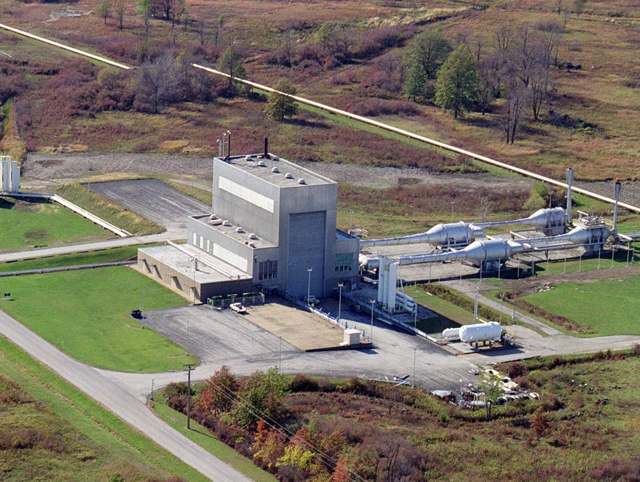
Photo: NASA, public domain · Wikimedia Commons
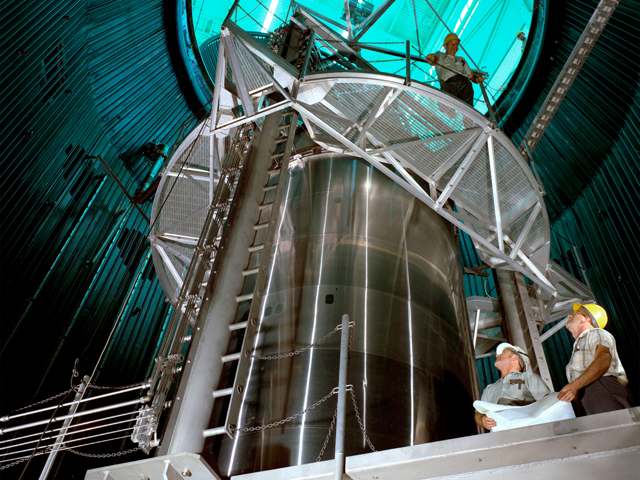
Photo: NASA Glenn Research Center, public domain · Wikimedia Commons
Local history sources: en.wikipedia.org · en.wikipedia.org · commons.wikimedia.org · commons.wikimedia.org · commons.wikimedia.org · commons.wikimedia.org · en.wikipedia.org · archive.org · archive.org · archive.org · archive.org · archive.org · archive.org · archive.org · archive.org
Historic places
3 places in Perkins Township, Erie County on the National Register of Historic Places, 1 of them National Historic Landmark. Press a pin or a name for its whole record.
-
Spacecraft Propulsion Research Facility LandmarkStructure · Sandusky · listed 1985
- Address
- Lewis Research Center, Plum Brook Station
- Where
- Sandusky, Erie County · ZIP 44870
- What it is
- Structure
- Listed on the National Register
- 1985
- National Historic Landmark
- Yes
- NRIS reference number
- 85002802
- Coordinates
- 41.36711, -82.68361
National Register file (NPS) ↗ Search Wikipedia ↗ Street map and directions ↗ On the Cracked Buckeye map
-
Erie County InfirmaryBuilding · Sandusky · listed 1975
- Address
- S of Sandusky on Columbus Rd.
- Where
- Sandusky, Erie County · ZIP 44870
- What it is
- Building
- Listed on the National Register
- 1975
- NRIS reference number
- 75001387
- Coordinates
- 41.42731, -82.69366
National Register file (NPS) ↗ Search Wikipedia ↗ Street map and directions ↗ On the Cracked Buckeye map
-
Oakland Cemetery Chapel and Superintendent's House and OfficeBuilding · Sandusky · listed 1983
- Address
- 2917 Milan Rd.
- Where
- Sandusky, Erie County · ZIP 44870
- What it is
- Building
- Listed on the National Register
- 1983
- NRIS reference number
- 83001962
- Coordinates
- 41.43074, -82.68669
National Register file (NPS) ↗ Search Wikipedia ↗ Street map and directions ↗ On the Cracked Buckeye map
Source: National Park Service, National Register of Historic Places point file. The listing year is shown where NPS's certification date agrees with the listing's reference number. Listing recognizes significance; it does not restrict a private owner.
Water
Lake Erie, drawn through a 42-inch gravity pipe about three-quarters of a mile offshore near Cedar Point Chaussee, with a Sandusky Bay intake used as backup The water here
- Sandusky City62% of residentsLake Erie (Sandusky Bay backup intake)
- Erie Co. Perkins District33% of residentsLake Erie (Sandusky Bay backup intake)
- Erie Co. Margaretta District5% of residentsLake Erie (Sandusky Bay backup intake)
Hospitals, fire stations and more
Inside Perkins Township, Erie County's boundary: 1 health center, 1 dialysis center, 3 nursing homes, 2 fire and EMS stations, 1 college, 4 public schools, 1 museum, 2 police stations, 4 public charging sites, 5 Toxics Release Inventory facilities and 21 spill cases. Press a pin or a name for its whole record and its source.
Community health centers (1)
-
ECCHC @ OVHHealth center · Sandusky
- Run by
- a federally qualified health center
- Setting
- Clinic
- City
- Sandusky
- Coordinates
- 41.41902, -82.68273
Find a Health Center (HRSA) ↗ HRSA data (source) ↗ Street map and directions ↗
Source: HRSA health center service delivery sites, active, September 2026 (school-based sites left out). Health centers see patients whether or not they have insurance, with fees on a sliding scale.
Dialysis centers (1)
-
Davita Home Dialysis Services Of Sandusky IncDialysis · Sandusky
- Address
- 2819 South Hayes, Suite 8, Sandusky, OH 44870
- Dialysis stations
- 2
- Medicare star rating
- 2 of 5 stars
- Services
- peritoneal dialysis
- Ownership
- for profit
- Chain
- DaVita
- Medicare certified since
- 2003-06-09
- Phone
- (419) 627-0477
- Medicare ID
- 362660
Medicare Care Compare ↗ CMS dialysis facility list (source) ↗ Street map and directions ↗
Source: CMS dialysis facility list, September 2026, geocoded with the Census Bureau batch geocoder (an address it could not place sits at its ZIP center).
Nursing homes (3)
-
Concord Care and Rehabilitation Center4 of 5 stars · Sandusky
- Address
- 620 W Strub Rd, Sandusky, OH 44870
- Certified beds
- 50
- Residents on an average day
- 47
- Medicare overall rating
- 4 of 5 stars
- Health inspections
- 3 of 5 stars
- Staffing
- 2 of 5 stars
- Quality measures
- 5 of 5 stars
- Penalties since 2023
- none
- Ownership
- For profit - Individual
- Chain
- AOM HEALTHCARE
- Takes
- Medicare and Medicaid
- Phone
- (419) 626-5373
- Medicare ID
- 365885
Medicare Care Compare ↗ CMS nursing home data (source) ↗ Street map and directions ↗
-
Ohio Veterans Home Abuse citation4 of 5 stars · Sandusky
- Address
- 3416 Columbus Ave, Sandusky, OH 44870
- Certified beds
- 427
- Residents on an average day
- 242
- Medicare overall rating
- 4 of 5 stars
- Health inspections
- 2 of 5 stars
- Staffing
- 5 of 5 stars
- Quality measures
- 5 of 5 stars
- Penalties since 2023
- none
- Abuse citation (CMS icon)
- Yes
- Ownership
- Government - State
- Takes
- Medicare and Medicaid
- Phone
- (419) 625-2454
- Medicare ID
- 366325
Medicare Care Compare ↗ CMS nursing home data (source) ↗ Street map and directions ↗
-
Parkvue Health Care Center5 of 5 stars · Sandusky
- Address
- 3800 Boardwalk Blvd, Sandusky, OH 44870
- Certified beds
- 84
- Residents on an average day
- 77
- Medicare overall rating
- 5 of 5 stars
- Health inspections
- 4 of 5 stars
- Staffing
- 4 of 5 stars
- Quality measures
- 5 of 5 stars
- Penalties since 2023
- none
- Ownership
- For profit - Corporation
- Chain
- UNITED CHURCH HOMES
- Continuing care retirement community
- Yes
- Takes
- Medicare and Medicaid
- Phone
- (419) 621-1900
- Medicare ID
- 365997
Medicare Care Compare ↗ CMS nursing home data (source) ↗ Street map and directions ↗
Source: CMS Care Compare nursing home provider and penalties files; Medicare star ratings run 1 to 5.
Fire and EMS stations (2)
-
Perkins Township Fire Department Station 2Sandusky
- Address
- 3003 Campbell Street, Sandusky, OH 44870
- Coordinates
- 41.42300, -82.70380
USGS National Map structures (source) ↗ Street map and directions ↗
-
Perkins Township Fire Department Station 3Sandusky
- Address
- 4510 Milan Road, Sandusky, OH 44870
- Coordinates
- 41.41375, -82.66882
USGS National Map structures (source) ↗ Street map and directions ↗
Source: USGS National Map structures (most Ohio records last updated 2019 to 2022), checked against the Columbus and Cleveland station lists. The department that answers a call is set by jurisdiction and mutual aid, not by distance.
Colleges (1)
-
Ohio Business College-SanduskyFor-profit two-year college · Sandusky
- What it is
- For-profit two-year college
- City
- Sandusky
- Students, 2023-24 (12-month count)
- 75
- Tuition and fees, in state
- $9,385
- Graduation rate
- 50% within three years (a class of 18)
- IPEDS unit ID
- 203739
College Navigator (NCES) ↗ IPEDS data (source) ↗ Street map and directions ↗
Source: NCES IPEDS 2024 directory, 2023-24 enrollment and tuition, graduation rates for the 2017 (four-year) and 2020 (two-year) entering classes.
Public schools (4)
-
Briar Middle School4 of 5 stars · Sandusky
- Address
- 3700 South Ave, Sandusky, OH 44870
- School district
- Perkins Local School District
- Kind (NCES)
- Regular School
- Students, 2023-24
- 402
- Teachers (full-time equivalent)
- 24.5
- Report card, 2025-26
- 4 of 5 stars
- Performance index
- 75.7%
- Ohio building IRN
- 029629
- NCES school ID
- 390468102664
NCES school record ↗ Ohio School Report Card ↗ Street map and directions ↗
-
Furry Elementary School3 of 5 stars · Sandusky
- Address
- 310 Douglas Dr, Sandusky, OH 44870
- School district
- Perkins Local School District
- Kind (NCES)
- Regular School
- Students, 2023-24
- 529
- Teachers (full-time equivalent)
- 27
- Report card, 2025-26
- 3 of 5 stars
- Ohio building IRN
- 012757
- NCES school ID
- 390468102661
NCES school record ↗ Ohio School Report Card ↗ Street map and directions ↗
-
Meadowlawn Elementary School4 of 5 stars · Sandusky
- Address
- 1313 E Strub Rd, Sandusky, OH 44870
- School district
- Perkins Local School District
- Kind (NCES)
- Regular School
- Students, 2023-24
- 404
- Teachers (full-time equivalent)
- 24
- Report card, 2025-26
- 4 of 5 stars
- Performance index
- 77.4%
- Ohio building IRN
- 023994
- NCES school ID
- 390468102662
NCES school record ↗ Ohio School Report Card ↗ Street map and directions ↗
-
Perkins High School4.5 of 5 stars · Sandusky
- Address
- 3714 Campbell St, Sandusky, OH 44870
- School district
- Perkins Local School District
- Kind (NCES)
- Regular School
- Students, 2023-24
- 583
- Teachers (full-time equivalent)
- 32.52
- Report card, 2025-26
- 4.5 of 5 stars
- Performance index
- 82.8%
- Four-year graduation rate
- 99.3%
- Ohio building IRN
- 029637
- NCES school ID
- 390468102663
NCES school record ↗ Ohio School Report Card ↗ Street map and directions ↗
Source: NCES EDGE public school locations 2024-25 and Common Core of Data 2023-24 (type, students, teachers); Ohio School Report Cards 2025-26 (Department of Education and Workforce), matched by name within the district.
Museums, historical societies, gardens and zoos (1)
-
Heritage Society Of Erie CountyHistorical society · Sandusky
- What it is
- Historical society
- City
- Sandusky
- Coordinates
- 41.42672, -82.69425
Search Wikipedia ↗ IMLS Museum Data Files (source) ↗ Street map and directions ↗
The museum list is IMLS's 2018 file; a museum may have closed or moved since.
Source: IMLS Museum Data Files, 2018.
Police stations (2)
-
Erie County Sheriff's OfficeSandusky
- Address
- 2800 Columbus Avenue, Sandusky, OH 44870
- Coordinates
- 41.42893, -82.69214
USGS National Map structures (source) ↗ Street map and directions ↗
-
Perkins Township Police DepartmentSandusky
- Address
- 2610 Columbus Avenue, Sandusky, OH 44870
- Coordinates
- 41.43037, -82.69522
USGS National Map structures (source) ↗ Street map and directions ↗
Source: USGS National Map structures, police stations, corrected and completed by hand (September 2026). The department that answers a call is set by jurisdiction, not by distance.
Public EV charging (4)
-
Foster Cadillac DC fast1 DC fast · SANDUSKY
- Address
- 2504 HAYES AVE., SANDUSKY, OH 44870
- Ports
- 1 DC fast
- Plugs
- CCS
- Network
- EV Connect
- Hours
- 24 hours daily
- Phone
- 866-816-7584
Station Locator (NREL) ↗ Alternative Fuels Data Center (source) ↗ Street map and directions ↗
-
Friendship Kitchen 83 DC fast4 DC fast · Sandusky
- Address
- 4024 Hayes Ave., Sandusky, OH 44870
- Ports
- 4 DC fast
- Plugs
- CCS, CHAdeMO
- Network
- EV Connect
- Hours
- 24 hours daily
- Phone
- 866-816-7584
Station Locator (NREL) ↗ Alternative Fuels Data Center (source) ↗ Street map and directions ↗
-
Mathews Ford S7 DC fast4 DC fast · 4 Level 2 · Sandusky
- Address
- 610 East Perkins Avenue, Sandusky, OH 44870
- Ports
- 4 DC fast · 4 Level 2
- Plugs
- CCS, J1772
- Network
- Blink Network
- Hours
- 24 hours daily
- Phone
- 888-998-2546
Station Locator (NREL) ↗ Alternative Fuels Data Center (source) ↗ Street map and directions ↗
-
Meijer - Tesla Supercharger DC fast10 DC fast · Sandusky
- Address
- 4702 Milan Road, Sandusky, OH 44870
- Ports
- 10 DC fast
- Plugs
- Tesla (NACS)
- Network
- Tesla
- Hours
- 24 hours daily. Please check Tesla's online station map to see if an adapter is required at this location.
- Phone
- 877-798-3752
Station Locator (NREL) ↗ Alternative Fuels Data Center (source) ↗ Street map and directions ↗
Source: NREL Alternative Fuels Data Center station list (May 2026), public and open stations, the posts at one address counted as one site.
Facilities reporting toxic releases (5)
-
Adm EnvironmentalToxics Release Inventory · Sandusky
- Address
- 3715 Shady Ln, Sandusky, OH 44870
- County
- Erie County
- Status
- Reports to the Toxics Release Inventory
- EPA program ID
- TRI_OFFSITE_35
- EPA registry ID
- 110070691719
EPA facility record ↗ EPA Facility Registry Service (source) ↗ Street map and directions ↗
-
Bechtel Mclaughlin IncToxics Release Inventory · Sandusky
- Address
- 3612 Milan Road, Sandusky, OH 44870
- County
- Erie County
- Status
- Reports to the Toxics Release Inventory (active)
- EPA program ID
- 44870BCHTL3612M
- EPA registry ID
- 110000391745
EPA facility record ↗ EPA Facility Registry Service (source) ↗ Street map and directions ↗
-
GmcToxics Release Inventory · Sandusky
- Address
- 2509 Hayes Avenue, Sandusky, OH 44870
- County
- Erie County
- Status
- Reports to the Toxics Release Inventory
- EPA program ID
- 44870NWDPR2509H
- EPA registry ID
- 110009668877
EPA facility record ↗ EPA Facility Registry Service (source) ↗ Street map and directions ↗
-
Rainbow Muffler & BrakeToxics Release Inventory · Sandusky
- Address
- 2806 Milan Rd, Sandusky, OH 44870
- County
- Erie County
- Status
- Reports to the Toxics Release Inventory (active)
- EPA program ID
- 44870GCFND2806W
- EPA registry ID
- 110043554043
EPA facility record ↗ EPA Facility Registry Service (source) ↗ Street map and directions ↗
-
Thorworks Industries IncToxics Release Inventory · Sandusky
- Address
- 2520 South Campbell Street, Sandusky, OH 44870
- County
- Erie County
- Status
- Reports to the Toxics Release Inventory (active)
- EPA program ID
- 44870THRWR252SC
- EPA registry ID
- 110021037028
EPA facility record ↗ EPA Facility Registry Service (source) ↗ Street map and directions ↗
Source: EPA Facility Registry Service, Toxics Release Inventory reporters. Reporting a release is required of large users of listed chemicals; it is not by itself a violation.
Spills reported since 2021 (21)
-
Mercury / Quicksilver (Hg)2025-10-14 · Perkins Twp
- Reported
- 2025-10-14
- What spilled
- Mercury / Quicksilver (Hg)
- Where
- Perkins Twp, Erie County
- Ohio EPA district office
- NWDO
- Ohio EPA case number
- 2510EPA0001701
Ohio EPA spill reports (source) ↗ Street map and directions ↗
-
Oil Petroleum Not Otherwise Specified (Nos)2025-09-24 · Perkins Twp
- Reported
- 2025-09-24
- What spilled
- Oil Petroleum Not Otherwise Specified (Nos)
- Largest amount reported
- 55 gallons
- Where
- Perkins Twp, Erie County
- Ohio EPA district office
- NWDO
- Ohio EPA case number
- 2509EPA0001598
Ohio EPA spill reports (source) ↗ Street map and directions ↗
-
Asphalt / Bitumen2025-09-02 · Perkins Twp
- Reported
- 2025-09-02
- What spilled
- Asphalt / Bitumen
- Largest amount reported
- 1,500 gallons
- Where
- Perkins Twp, Erie County
- Ohio EPA district office
- NWDO
- Ohio EPA case number
- 2509EPA0001476
Ohio EPA spill reports (source) ↗ Street map and directions ↗
-
Refrigerant Other Or Unk Type2025-08-27 · Perkins Twp
- Reported
- 2025-08-27
- What spilled
- Refrigerant Other Or Unk Type
- Where
- Perkins Twp, Erie County
- Ohio EPA district office
- NWDO
- Ohio EPA case number
- 2508EPA0001456
Ohio EPA spill reports (source) ↗ Street map and directions ↗
-
Material Blue2025-08-17 · Perkins Twp
- Reported
- 2025-08-17
- What spilled
- Material Blue
- Where
- Perkins Twp, Erie County
- Ohio EPA district office
- NWDO
- Ohio EPA case number
- 2508EPA0001388
Ohio EPA spill reports (source) ↗ Street map and directions ↗
-
Oil Transformer Non Pcb2025-06-09 · Perkins Twp
- Reported
- 2025-06-09
- What spilled
- Oil Transformer Non Pcb
- Largest amount reported
- 60 gallons
- Where
- Perkins Twp, Erie County
- Ohio EPA district office
- NWDO
- Ohio EPA case number
- 2506EPA0000943
Ohio EPA spill reports (source) ↗ Street map and directions ↗
-
Oil Motor / Lube Oil / Vehicle Reached water2024-09-03 · Perkins Twp
- Reported
- 2024-09-03
- What spilled
- Oil Motor / Lube Oil / Vehicle
- Largest amount reported
- 1 gallons
- Reached a waterway
- 99 - Unnamed
- Where
- Perkins Twp, Erie County
- Ohio EPA district office
- NWDO
- Ohio EPA case number
- 2409EPA0001513
Ohio EPA spill reports (source) ↗ Street map and directions ↗
-
Other / All Other / Trade Name / Mixture / Solution Etc2024-03-10 · Perkins Twp
- Reported
- 2024-03-10
- What spilled
- Other / All Other / Trade Name / Mixture / Solution Etc
- Where
- Perkins Twp, Erie County
- Ohio EPA district office
- NWDO
- Ohio EPA case number
- 2403EPA0000382
Ohio EPA spill reports (source) ↗ Street map and directions ↗
-
Sheen Rainbow / Hydrocarbon Reached water2023-10-31 · Perkins Twp
- Reported
- 2023-10-31
- What spilled
- Sheen Rainbow / Hydrocarbon
- Reached a waterway
- 99 - Unnamed
- Where
- Perkins Twp, Erie County
- Ohio EPA district office
- NWDO
- Ohio EPA case number
- 2310EPA0001863
Ohio EPA spill reports (source) ↗ Street map and directions ↗
-
Oil Petroleum Not Otherwise Specified (Nos)2023-10-25 · Perkins Twp
- Reported
- 2023-10-25
- What spilled
- Oil Petroleum Not Otherwise Specified (Nos)
- Where
- Perkins Twp, Erie County
- Ohio EPA district office
- NWDO
- Ohio EPA case number
- 2310EPA0001825
Ohio EPA spill reports (source) ↗ Street map and directions ↗
-
Sewage Human Reached water2023-08-24 · Perkins Twp
- Reported
- 2023-08-24
- What spilled
- Sewage Human
- Reached a waterway
- 22 - Lake Erie
- Where
- Perkins Twp, Erie County
- Ohio EPA district office
- NWDO
- Ohio EPA case number
- 2308EPA0001477
Ohio EPA spill reports (source) ↗ Street map and directions ↗
-
Sheen Organic Reached water2023-07-24 · Perkins Twp
- Reported
- 2023-07-24
- What spilled
- Sheen Organic
- Reached a waterway
- 99 - Unnamed
- Where
- Perkins Twp, Erie County
- Ohio EPA district office
- NWDO
- Ohio EPA case number
- 2307EPA0001253
Ohio EPA spill reports (source) ↗ Street map and directions ↗
-
Oil Hydraulic Fluid(S)2023-05-20 · Perkins Twp
- Reported
- 2023-05-20
- What spilled
- Oil Hydraulic Fluid(S)
- Largest amount reported
- 55 gallons
- Where
- Perkins Twp, Erie County
- Ohio EPA district office
- NWDO
- Ohio EPA case number
- 2305EPA0000826
Ohio EPA spill reports (source) ↗ Street map and directions ↗
-
Solid Waste Nos (Not Specified)2023-05-13 · Perkins Twp
- Reported
- 2023-05-13
- What spilled
- Solid Waste Nos (Not Specified)
- Where
- Perkins Twp, Erie County
- Ohio EPA district office
- NWDO
- Ohio EPA case number
- 2305EPA0000782
Ohio EPA spill reports (source) ↗ Street map and directions ↗
-
Anhydrous Ammonia (Nh3)2023-01-14 · Perkins Twp
- Reported
- 2023-01-14
- What spilled
- Anhydrous Ammonia (Nh3)
- Where
- Perkins Twp, Erie County
- Ohio EPA district office
- NWDO
- Ohio EPA case number
- 2301EPA0000077
Ohio EPA spill reports (source) ↗ Street map and directions ↗
-
Other / All Other / Trade Name / Mixture / Solution Etc2022-12-28 · Perkins Twp
- Reported
- 2022-12-28
- What spilled
- Other / All Other / Trade Name / Mixture / Solution Etc
- Largest amount reported
- 96 gallons
- Where
- Perkins Twp, Erie County
- Ohio EPA district office
- NWDO
- Ohio EPA case number
- 2212EPA0001923
Ohio EPA spill reports (source) ↗ Street map and directions ↗
-
Material Unknown2022-11-30 · Perkins Twp
- Reported
- 2022-11-30
- What spilled
- Material Unknown
- Where
- Perkins Twp, Erie County
- Ohio EPA district office
- NWDO
- Ohio EPA case number
- 2211EPA0001773
Ohio EPA spill reports (source) ↗ Street map and directions ↗
-
Sheen Organic Reached water2022-06-11 · Perkins Twp
- Reported
- 2022-06-11
- What spilled
- Sheen Organic
- Reached a waterway
- 22 - Pipe Creek
- Where
- Perkins Twp, Erie County
- Ohio EPA district office
- NWDO
- Ohio EPA case number
- 2206EPA0000880
Ohio EPA spill reports (source) ↗ Street map and directions ↗
-
Fuel Diesel / Diesel Fuel (Vehicle On Or Off Road)2021-05-22 · Perkins Twp
- Reported
- 2021-05-22
- What spilled
- Fuel Diesel / Diesel Fuel (Vehicle On Or Off Road)
- Largest amount reported
- 25 gallons
- Where
- Perkins Twp, Erie County
- Ohio EPA district office
- NWDO
- Ohio EPA case number
- 2105EPA0000720
Ohio EPA spill reports (source) ↗ Street map and directions ↗
-
Propane (C3H8)2021-02-04 · Perkins Twp
- Reported
- 2021-02-04
- What spilled
- Propane (C3H8)
- Where
- Perkins Twp, Erie County
- Ohio EPA district office
- NWDO
- Ohio EPA case number
- 2102EPA0000163
Ohio EPA spill reports (source) ↗ Street map and directions ↗
-
Oil Transformer Non Pcb2026-06-10 · Perkins Twp
- Reported
- 2026-06-10
- What spilled
- Oil Transformer Non Pcb
- Largest amount reported
- 25 gallons
- Where
- Perkins Twp, Erie County
- Ohio EPA district office
- NWDO
- Ohio EPA case number
- 2606EPA0001025
Ohio EPA spill reports (source) ↗ Street map and directions ↗
Source: Ohio EPA emergency response spill reports, 2021 to September 2026, one point per case where Ohio EPA placed it. A report is what the caller or responder recorded; amounts are often blank or estimated.
Its ZIP codes
Each ZIP code that touches Perkins Township, Erie County, with the share of its residents who live here and the same headline figures as the ZIP page.
| ZIP | Share | Water | Radon | Home value | Schools | Flood |
|---|---|---|---|---|---|---|
| 44870 Sandusky | 31% | Lake Erie, drawn through a 42-inch gravity pipe about three-quarters of a mile offshore near Cedar Point Chaussee, with a Sandusky Bay intake used as backup | 3.8 pCi/L average radon | Median year built 1955 | Sandusky City · 2.5 stars overall | 7.1% of residents in the 1% floodplain |
Local government
Who holds office in Perkins Township, Erie County, how its elections and ballot issues came out, and the state auditor's record.
Money issues on the ballot since 2017: 6 of 6 passed; of those asking for new or higher taxes, 2 of 2.
Ballot issues
| Date | Issue | For | Against | Result |
|---|---|---|---|---|
| 2022-11-08 | Issue 13: Issue 13 Perkins Township - Renewal Levy, Police Protection, 5.5 mills, for 5 years (5.5 mills, renewal) | 3,666 | 1,373 | Passed (72.75% for), unofficial |
| 2022-11-08 | Issue 14: Issue 14 Perkins Township - Renewal Levy, Fire & EMS, 5.5 mills, for 5 years (5.5 mills, renewal) | 3,906 | 1,127 | Passed (77.61% for), unofficial |
| 2022-11-08 | Issue 15: Issue 15 Perkins Township - Proposed resolution for limited home rule | 1,327 | 3,399 | Failed (28.08% for), unofficial |
| 2021-11-02 | 16: 16 Proposed Tax Levy (Additional) - Perkins Township (Fire and Emergency Medical | 1,716 | 818 | Passed (67.72% for) |
| 2021-11-02 | 17: 17 Proposed Tax Levy (Additional) - Perkins Township (Police, 2.75 mills) (2.75 mills, additional) | 1,674 | 861 | Passed (66.04% for) |
| 2017-11-07 | 13: #13Perkins Township Tax Levy Renewal Fire Protection& EMS | 2,896 | 881 | Passed (76.67% for) |
| 2017-11-07 | 14: #14 Perkins Township Tax Levy Renewal Police Protection | 2,933 | 835 | Passed (77.84% for) |
Elections for office
| Date | Office | Candidates and votes |
|---|---|---|
| 2021-11-02 | Township Trustee | Timothy Coleman 1,520, 46.19%; Jim Lang 1,771, 53.81% |
| 2019-11-05 | Township Trustee | Jeffrey Philip Fantozzi 962, 48.17%; Jeffrey L. Ferrell 1,035, 51.83% |
| 2019-11-05 | Township Fiscal Officer | Diane L. Schaefer 1,534, 100.0% |
Winners in bold. Results from the county board of elections' official canvass unless marked.
Auditor of State record
- No fiscal caution, watch or emergency on the Auditor of State's lists.
- Financial Audit, 2023 to 2024, released 2026-01-20
The county
Erie County: 7 ZIP codes, 15 cities, villages and townships, 78,997 people.
Nearby places
Quick answers
What county is Perkins Township, Ohio in?
Perkins Township, Erie County is a township in Erie County, Ohio, with 12,387 residents.
When was Perkins Township, Ohio founded?
Perkins Township, Erie County was settled 1810 (Thomas James, first actual settler); incorporated 1818 (first township election, spring 1818). Founders on record: Rev. John Beatty, who bought nearly the whole township in 1810 and settled a Connecticut colony there in 1815. Source
How did Perkins Township, Ohio get its name?
Named for Hon. Source
What ZIP code is Perkins Township, Ohio?
Most of Perkins Township, Erie County is in ZIP code 44870.
Where does Perkins Township, Ohio get its water?
The main water source for Perkins Township, Erie County (Sandusky City): Lake Erie, drawn through a 42-inch gravity pipe about three-quarters of a mile offshore near Cedar Point Chaussee, with a Sandusky Bay intake used as backup.
Cite this page
Cite this page as:
Cracked Buckeye, "Perkins Township, Erie County", https://crackedbuckeye.com/place/perkins-township-erie-county/, built 2026-10-31, accessed [date].
How to cite · Report a correction · Built 2026-10-31
