Port Washington
Village · Tuscarawas County · 548 residents · 1.5% municipal income tax
Local events in Port Washington
Nothing is posted for Port Washington itself yet; here is what is on within 20 miles. All local events in Port Washington
Know a calendar we should watch? Send the link
Checked October 20; the events page is refreshed daily.
How Port Washington began
Port Washington was originally laid out in 1827 under the name Salisbury (rendered "Salesburg" in one county history) by John Knight, on Salem Township land along the Ohio and Erie Canal in southwestern Tuscarawas County. It took its present name when the Port Washington post office opened in 1832, reflecting its role as a small canal port. The Port Washington Town Hall on Main Street, listed on the National Register of Historic Places in 1979, is the village's National Register listing. The village had 548 residents at the 2020 census.
Platted 1827 (as Salisbury; replatted 1829 and 1832), incorporated 1868, by John Knight.
Where the name comes from
Laid out in 1827 as Salisbury (recorded elsewhere as "Salesburg"), the town was renamed Port Washington when its post office opened in 1832, marking it as a landing on the Ohio and Erie Canal.
Before the town
No Native American history specific to the site of Port Washington was found; the village was platted in 1827, more than three decades after the 1795 Treaty of Greenville ceded most of the surrounding land. For the county's record of prehistoric mound-building cultures, the historic nations who lived, hunted or traveled through the Tuscarawas Valley, and the treaties and removal that affected the county.
Timeline
- — John Knight lays out the town of Salisbury on Lot 21 in Salem Township, the site that becomes Port Washington.
- — Salisbury is replatted with 65 lots, then 73 in 1832 and enlarged by John Knight in 1838 with 62 more lots.
- — Milligan and Gaskill build a saw mill serving the Port Washington area of Salem Township.
- — A post office named Port Washington opens, and the town takes that name.
- — Port Washington has 116 residents; a frame meeting house shared by Methodist Protestants and Methodist Episcopals is built about this time.
- — Lawbaugh builds a grist mill at canal lock 18 near Port Washington capable of grinding 200 barrels of flour daily.
- — A Methodist church and a Lutheran church are built in Port Washington the same year, per the genealogytrails township history; the 1884 county history instead dates the frame Methodist meeting house to about 1840 and the German Lutheran congregation's organization to 1851.
- — Population 260.
- — The German Evangelical Lutheran congregation is organized under Rev. Carl Doeppenschmidt.
- — The public union school system is adopted about this year; a two-story frame school is built in 1859 and first used in September 1860.
- — Port Washington is incorporated as a village; Dr. David Nelson is elected the first mayor but resigns, and L. A. Cornet fills the vacancy.
- — The village buys its fire engine; in 1878-79 it builds the three-story brick town hall for about $3,500.
- — The Port Washington Town Hall on Main Street is listed on the National Register of Historic Places on February 22.
- — Population 634 (425 in 1870).
- — The Port Washington Moravian church is organized on March 5 with 28 members by Rev. J. H. Clewell.
Stories
From Salisbury to a canal port
When John Knight laid out his town on Lot 21 of Salem Township in 1827, he called it Salisbury. The name did not stick. When the community got its own post office in 1832, it took the name Port Washington instead, a name that announced what the settlement actually was: a stop on the Ohio and Erie Canal, the waterway then transforming the Tuscarawas Valley from a scatter of farms into a trade corridor. Mills followed the canal traffic — a saw mill in 1831-32, and by 1843 a grist mill at lock 18 large enough to turn out two hundred barrels of flour a day, a scale that only made sense with a canal to ship the flour out on. The Port Washington Town Hall still stands on Main Street and is the village's entry on the National Register of Historic Places, listed in 1979.
The man who came to build a mill
John Knight came to the Salem tract from Antrim, in Harrison County, to build a mill across the Tuscarawas just above the bridge, but a fever stopped the project. He laid out a town instead, which he called Salisbury, on the new Ohio Canal in 1827, opened a store and warehouse, and finished a tavern begun by Thomas Moore. Charles Hill and Richard Carr built the first houses; Hill opened the first store in his own dwelling and built a canal boat in the street, while Benjamin Carr kept the first tavern near the towpath. Knight kept the inn for many years before moving to a farm in Oxford Township. The town grew with the canal to 634 people by 1880.
Photographs
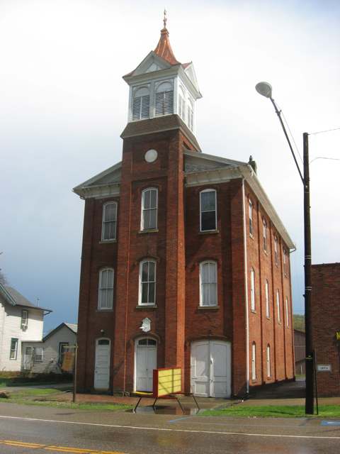
Photo: Nyttend (Wikimedia Commons), public domain · Wikimedia Commons
Local history sources: en.wikipedia.org · genealogytrails.com · en.wikipedia.org · commons.wikimedia.org · archive.org
Historic places
1 place in Port Washington on the National Register of Historic Places. Press a pin or a name for its whole record.
-
Port Washington Town HallBuilding · Port Washington · listed 1979
- Address
- Main St.
- Where
- Port Washington, Tuscarawas County · ZIP 43837
- What it is
- Building
- Listed on the National Register
- 1979
- NRIS reference number
- 79001971
- Coordinates
- 40.32796, -81.51872
National Register file (NPS) ↗ Search Wikipedia ↗ Street map and directions ↗ On the Cracked Buckeye map
Source: National Park Service, National Register of Historic Places point file. The listing year is shown where NPS's certification date agrees with the listing's reference number. Listing recognizes significance; it does not restrict a private owner.
Water
No water-system data is linked to Port Washington's ZIP codes yet.
Hospitals, fire stations and more
Inside Port Washington's boundary: 1 fire or EMS station, 1 public school and 1 police station. Press a pin or a name for its whole record and its source.
Fire and EMS stations (1)
-
Delaware Valley Joint Fire District Station 4Port Washington
- Address
- 107 East Main Street, Port Washington, OH 43837
- Coordinates
- 40.32799, -81.51874
USGS National Map structures (source) ↗ Street map and directions ↗
Source: USGS National Map structures (most Ohio records last updated 2019 to 2022), checked against the Columbus and Cleveland station lists. The department that answers a call is set by jurisdiction and mutual aid, not by distance.
Public schools (1)
-
Port Washington Elementary School4 of 5 stars · Port Washington
- Address
- 304 E Arch St, Port Washington, OH 43837
- School district
- Indian Valley Local School District
- Kind (NCES)
- Regular School
- Students, 2023-24
- 403
- Teachers (full-time equivalent)
- 18.5
- Report card, 2025-26
- 4 of 5 stars
- Performance index
- 90.3%
- Ohio building IRN
- 030866
- NCES school ID
- 390502803901
NCES school record ↗ Ohio School Report Card ↗ Street map and directions ↗
Source: NCES EDGE public school locations 2024-25 and Common Core of Data 2023-24 (type, students, teachers); Ohio School Report Cards 2025-26 (Department of Education and Workforce), matched by name within the district.
Police stations (1)
-
Port Washington Police DepartmentPort Washington
- Address
- 107 East Main Street, Port Washington, OH 43837
- Coordinates
- 40.32785, -81.51873
USGS National Map structures (source) ↗ Street map and directions ↗
Source: USGS National Map structures, police stations, corrected and completed by hand (September 2026). The department that answers a call is set by jurisdiction, not by distance.
Its ZIP codes
Each ZIP code that touches Port Washington, with the share of its residents who live here and the same headline figures as the ZIP page.
| ZIP | Share | Water | Radon | Home value | Schools | Flood |
|---|---|---|---|---|---|---|
| 43837 Port Washington | 31% | Mostly private wells | 18.6 pCi/L average radon | Median year built 1972 | Indian Valley Local · 4.5 stars overall | 2.8% of residents in the 1% floodplain |
Local government
Who holds office in Port Washington, how its elections and ballot issues came out, and the state auditor's record.
Money issues on the ballot since 2020: 2 of 2 passed.
Ballot issues
| Date | Issue | For | Against | Result |
|---|---|---|---|---|
| 2020-11-03 | 1: 1 Proposed Tax Levy (Renewal) Village of Port Washington Port Washington Vlg | 152 | 85 | Passed (64.14% for) |
| 2020-11-03 | 2: 2 Proposed Tax Levy (Renewal) Village of Port Washington Port Washington Vlg | 167 | 68 | Passed (71.06% for) |
| 2019-11-05 | Issue: Village of Port Washington Tax Increase Port Washington Vlg | 35 | 49 | Failed (41.67% for) |
Elections for office
| Date | Office | Candidates and votes |
|---|---|---|
| 2019-11-05 | Member of Council | Joe A. Bourne 71, 100.0% |
| 2019-11-05 | Mayor | Tom Gardner 75, 100.0% |
Winners in bold. Results from the county board of elections' official canvass unless marked.
The county
Tuscarawas County: 17 ZIP codes, 40 cities, villages and townships, 92,903 people.
Nearby places
Rain and snow
How much has actually fallen on Port Washington, day by day, from 1893 to now. Daily totals, not averages.
- rain, last 30 days
- 0.95 in
- 2026-09-30 to 2026-10-29
- rain so far in 2026
- 38.4 in
- 3.3 in above normal for the date
- snow so far in 2026
- 25.7 in
- a normal year brings 19.2 in
- a normal year
- 41.2 in
- average of 30 years, 1991-2020
| Month | Rain (in) | Snow (in) | Days counted |
|---|---|---|---|
| October 2026 | 0.95 | — | 29 |
| September 2026 | 3.79 | — | 30 |
| August 2026 | 7.22 | — | 31 |
| July 2026 | 3.71 | — | 31 |
| June 2026 | 3.87 | — | 30 |
| May 2026 | 5.35 | — | 31 |
| April 2026 | 4.59 | — | 30 |
| March 2026 | 5.50 | 2.1 | 31 |
| February 2026 | 1.49 | 3.3 | 28 |
| January 2026 | 1.91 | 20.2 | 31 |
| December 2025 | 2.52 | 10.9 | 31 |
| November 2025 | 2.17 | 0.1 | 30 |
| Wettest year | 2004 — 58.9 in |
|---|---|
| Driest year | 1930 — 25.2 in |
| Snowiest year | 1910 — 59.4 in |
| Wettest day on record | 7 August 1935 — 3.76 in |
| Heaviest snowfall in a day | 9 November 1913 — 11.68 in |
| Deepest snow on the ground | 21 January 1978 — 18.90 in |
Estimated, not measured. No rain gauge has ever stood inside Port Washington, so every figure here is worked out from the gauges around it - the nearest ones weighted most. Treat them as close estimates rather than readings.
48,471 days of records, 1893-01-01 to 2026-10-29. Source: NOAA NCEI GHCN-Daily, 3,240 gauges in and around Ohio. A day is "gauged" when a gauge standing inside the boundary reported it, and the value is the mean of those gauges. Otherwise it is interpolated by inverse distance from every gauge reporting within 50 miles. Nothing is carried forward, back-filled or smoothed. Against NOAA nClimDiv county monthly precipitation over 136,848 complete county-months (checked 2026-10-31): correlation 0.9515, median absolute difference 0.217 in a month. Built 2026-10-31 from the Cracked Buckeye precipitation archive. Snow is the softer number — snowfall is measured by hand with a ruler, no agency publishes a gridded county snowfall series, and blowing snow defeats every observer.
Environmental permits and filings
What Ohio EPA has on file for Port Washington: permits, inspections, violations, cleanups and the state loans behind sewer and water work. Every line links to the agency's own document.
- facilities and sites on file
- 12
- those placed on the map inside Port Washington
| Program | Facilities and sites |
|---|---|
| Public drinking water | 5 |
| Hazardous waste | 3 |
| Source-water protection | 3 |
| Contaminated-site cleanup | 1 |
| Date | Facility or site | What |
|---|---|---|
| BATES METAL PRODUCTS,INC PWS | Public drinking water compliance letter | |
| BATES METAL PRODUCTS,INC PWS | Public drinking water plan | |
| BATES METAL PRODUCTS,INC PWS | Public drinking water inspection | |
| ST. PAULS CHURCH PWS | Public drinking water inspection | |
| ST. PAULS CHURCH PWS | Public drinking water notice of violation | |
| BATES METAL PRODUCTS,INC PWS | Source-water protection report | |
| TONYS 76 PWS | Source-water protection letter | |
| ST. PAULS CHURCH PWS | Source-water protection report | |
| TONYS 76 PWS | Source-water protection report | |
| LAMPLIGHTER INN PWS | Public drinking water inspection | |
| TONYS 76 PWS | Public drinking water inspection | |
| ST. PAULS CHURCH PWS | Public drinking water inspection | |
| BATES METAL PRODUCTS,INC PWS | Public drinking water compliance letter | |
| LAMPLIGHTER INN PWS | Public drinking water compliance letter | |
| TONYS 76 PWS | Public drinking water compliance letter | |
| LAMPLIGHTER INN PWS | Public drinking water inspection | |
| BATES METAL PRODUCTS,INC PWS | Public drinking water compliance letter | |
| TONYS 76 PWS | Public drinking water inspection | |
| TONYS 76 PWS | Public drinking water notice of violation | |
| LAMPLIGHTER INN PWS | Public drinking water compliance letter | |
| TONYS 76 PWS | Public drinking water compliance letter | |
| BATES METAL PRODUCTS,INC PWS | Public drinking water compliance letter | |
| TONYS 76 PWS | Public drinking water permit | |
| BATES METAL PRODUCTS,INC PWS | Public drinking water permit | |
| LAMPLIGHTER INN PWS | Public drinking water permit |
Source: Ohio EPA eDocument portal (edocpub.epa.ohio.gov), indexed 2026-10-14. Facilities are placed on the map from Ohio EPA's own map layers, EPA's Facility Registry, coordinates written in the filings, or a geocoded street address. A permit filed under a private person's name (most are household septic systems) is counted but never named, placed or linked; licenses for individual workers and open-burning notices are left out entirely.
Quick answers
What county is Port Washington, Ohio in?
Port Washington is a village in Tuscarawas County, Ohio, with 548 residents.
When was Port Washington, Ohio founded?
Port Washington was laid out 1827 (as Salisbury; replatted 1829 and 1832); incorporated 1868. Founders on record: John Knight. Source
How did Port Washington, Ohio get its name?
Laid out in 1827 as Salisbury (recorded elsewhere as "Salesburg"), the town was renamed Port Washington when its post office opened in 1832, marking it as a landing on the Ohio and Erie Canal. Source
What ZIP code is Port Washington, Ohio?
Most of Port Washington is in ZIP code 43837.
Where does Port Washington, Ohio get its water?
The main water source for Port Washington: Mostly private wells.
Cite this page
Cite this page as:
Cracked Buckeye, "Port Washington, Tuscarawas County", https://crackedbuckeye.com/place/port-washington/, built 2026-10-31, accessed [date].
How to cite · Report a correction · Built 2026-10-31
