Local events in Parma Heights
41 events in the next 90 days from 5 public calendars. All local events in Parma Heights
Checked October 20; the events page is refreshed daily.
How Parma Heights began
The land that became Parma Heights was surveyed in 1806 by Abraham Tappan of the Connecticut Land Company as Township 6, Range 13, and first settled in 1817, a year after Benajah Fay's family arrived nearby; Parma Township organized in 1826, its first eleven officers elected at Samuel Freeman's house. In 1911 the northern part of the township split off as the village of Parma Heights by a narrow 42-32 vote, driven largely by a desire for the community's own town marshal and control over Sunday saloon operations. Parma Heights became a city in December 1956 under Mayor Roy F. Cappallo, and today is a compact residential Cleveland suburb of about 20,900 -- one whose city hall was firebombed with a Molotov cocktail in 2014, destroying the mayor's office.
Settled 1817, platted 1806 (Abraham Tappan survey, Connecticut Land Company), incorporated 1826 (Parma Township); 1911 (village of Parma Heights, split from Parma Township); 1956-12 (city), by Abraham Tappan (surveyor); early Parma Township settlers.
Where the name comes from
Parma Heights takes its name from Parma Township, itself renamed around 1826 from 'Greenbriar' at the urging of Dr. David Long, who had recently traveled to Parma, Italy and thought the township deserved a grander name; 'Heights' was added when the northern part of the township incorporated separately in 1911.
Before the town
No source we reviewed names a specific Native American village, trail or burial site confirmed within present Parma Heights. Wikipedia's Parma Heights article repeats a claim -- also found, in nearly identical wording, on Parma's own Wikipedia article -- that the 1849 Phillip Henninger House stood on one of Cuyahoga County's higher points, where 'the Erie Indians, centuries before, also stood to read and send fire signals'; the Henninger House's National Register listing is tied to a Parma ZIP code, not a Parma Heights one, so we treat the claim as belonging to Parma rather than repeating it as a Parma Heights fact, and could not resolve why it appears on both cities' pages. The area lies within the Connecticut Western Reserve, secured for settlement by the 1785 Treaty of Fort McIntosh and the 1795 Treaty of Greenville.
Timeline
- — Abraham Tappan surveys the township for the Connecticut Land Company as Township 6, Range 13.
- — Benajah Fay, his wife Ruth Wilcox Fay and their ten children settle nearby from Lewis County, New York.
- — The specific area that becomes Parma Heights is settled.
- — Parma Township is formally established; its first eleven officers are elected April 3 at Samuel Freeman's house.
- — The northern part of Parma Township splits off as the village of Parma Heights by a 42-32 vote, driven largely by a desire for the community's own town marshal and control over Sunday saloon hours.
- — Parma Heights incorporates as a city under Mayor Roy F. Cappallo.
- — An early-morning Molotov cocktail fire, deliberately set, destroys Mayor Mike Byrne's office and severely damages Parma Heights City Hall.
- — The Parma Heights man who set the city hall fire is sentenced to four years in prison.
Stories
Splitting off over a marshal and Sunday saloon hours
By 1911, the northern part of Parma Township had grown different enough from the rural south that residents pushed to break away and run their own affairs -- specifically, local accounts tie the drive to wanting a town marshal of their own and the power to control whether saloons could operate on Sundays, matters the township government evidently wasn't handling to local satisfaction. The vote to incorporate as the separate village of Parma Heights passed narrowly, 42 to 32, a margin close enough that a handful of changed minds would have kept the whole northern section under Parma Township government. Instead, Parma Heights spent the next forty-five years as its own village before becoming a city in December 1956 under Mayor Roy F. Cappallo -- a century-long trajectory from a scattering of Connecticut Land Company farm lots to an independent Cleveland suburb, set in motion by a dispute over drinking hours.
A firebomb in the mayor's office
In the early hours of November 26, 2014, someone threw a Molotov cocktail into Parma Heights City Hall, and the resulting fire destroyed Mayor Mike Byrne's office outright and did severe damage to the rest of the building -- an act investigators determined was deliberately set rather than accidental. A Parma Heights man was arrested and, in March 2015, sentenced to four years in prison for the attack. The episode stands out in an otherwise quiet suburban history as a genuinely violent act against local government, rare enough in a Cleveland-area inner-ring suburb that it remains one of the most-cited recent events in the city's own account of itself.
Photographs
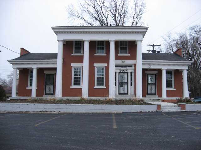
Photo: Nyttend (Wikimedia Commons), public domain · Wikimedia Commons
Local history sources: en.wikipedia.org · en.wikipedia.org · commons.wikimedia.org
Historic places
1 place in Parma Heights on the National Register of Historic Places. Press a pin or a name for its whole record.
-
Henry, Robert W., HouseBuilding · Parma Heights · listed 1978
- Address
- 6607 Pearl Rd.
- Where
- Parma Heights, Cuyahoga County · ZIP 44130
- What it is
- Building
- Listed on the National Register
- 1978
- NRIS reference number
- 78002048
- Coordinates
- 41.38274, -81.77842
National Register file (NPS) ↗ Search Wikipedia ↗ Street map and directions ↗ On the Cracked Buckeye map
Source: National Park Service, National Register of Historic Places point file. The listing year is shown where NPS's certification date agrees with the listing's reference number. Listing recognizes significance; it does not restrict a private owner.
Water
Lake Erie, through a tunnel from an offshore crib to the lakefront plant at W. 45th St. and Division Ave. The water here
- Cleveland Public Water System100% of residentsLake Erie
Hospitals, fire stations and more
Inside Parma Heights's boundary: 1 dialysis center, 1 nursing home, 1 fire or EMS station, 1 public school, 2 private schools, 1 library, 1 museum, 1 public charging site and 5 spill cases. Press a pin or a name for its whole record and its source.
Dialysis centers (1)
-
Davita Parma Heights DialysisDialysis · Parma Heights
- Address
- 9050 North Church Drive, Parma Heights, OH 44130
- Dialysis stations
- 19
- Medicare star rating
- 3 of 5 stars
- Services
- in-center hemodialysis, peritoneal dialysis, home hemodialysis training
- Ownership
- for profit
- Chain
- DaVita
- Medicare certified since
- 2007-06-15
- Phone
- (440) 842-0895
- Medicare ID
- 362704
Medicare Care Compare ↗ CMS dialysis facility list (source) ↗ Street map and directions ↗
Source: CMS dialysis facility list, September 2026, geocoded with the Census Bureau batch geocoder (an address it could not place sits at its ZIP center).
Nursing homes (1)
-
Greenbrier Health Center2 of 5 stars · Parma Heights
- Address
- 6455 Pearl Rd, Parma Heights, OH 44130
- Certified beds
- 162
- Residents on an average day
- 119
- Medicare overall rating
- 2 of 5 stars
- Health inspections
- 1 of 5 stars
- Staffing
- 2 of 5 stars
- Quality measures
- 5 of 5 stars
- Penalties since 2023
- 1 fine totalling $26,685 (latest 2025-10-08)
- Ownership
- For profit - Corporation
- Chain
- COMMUNICARE HEALTH
- Takes
- Medicare and Medicaid
- Phone
- (440) 888-5900
- Medicare ID
- 365192
Medicare Care Compare ↗ CMS nursing home data (source) ↗ Street map and directions ↗
Source: CMS Care Compare nursing home provider and penalties files; Medicare star ratings run 1 to 5.
Fire and EMS stations (1)
-
Parma Heights Fire DepartmentParma Heights
- Address
- 6184 Pearl Road, Parma Heights, OH 44130
- Coordinates
- 41.39347, -81.75890
USGS National Map structures (source) ↗ Street map and directions ↗
Source: USGS National Map structures (most Ohio records last updated 2019 to 2022), checked against the Columbus and Cleveland station lists. The department that answers a call is set by jurisdiction and mutual aid, not by distance.
Public schools (1)
-
Valley Forge High School3.5 of 5 stars · Parma Heights
- Address
- 9999 Independence Blvd, Parma Heights, OH 44130
- School district
- Parma City School District
- Kind (NCES)
- Regular School
- Students, 2023-24
- 1,452
- Teachers (full-time equivalent)
- 79.83
- Report card, 2025-26
- 3.5 of 5 stars
- Performance index
- 71.1%
- Four-year graduation rate
- 92.9%
- Ohio building IRN
- 038109
- NCES school ID
- 390446301519
NCES school record ↗ Ohio School Report Card ↗ Street map and directions ↗
Source: NCES EDGE public school locations 2024-25 and Common Core of Data 2023-24 (type, students, teachers); Ohio School Report Cards 2025-26 (Department of Education and Workforce), matched by name within the district.
Private schools (2)
-
Incarnate Word AcademyPrivate, Catholic · Parma Heights
- Address
- 6620 Pearl Rd, Parma Heights, OH 44130
- Kind
- Catholic
- Students, 2023-24
- 383
- Teachers (full-time equivalent)
- 28
- Students per teacher
- 13.6786
- Phone
- (440) 842-6818
- NCES private school ID
- 01059133
-
Parma Heights Christian AcademyPrivate, conservative Christian · Parma Heights
- Address
- 8971 W Ridgewood Dr, Parma Heights, OH 44130
- Kind
- conservative Christian
- Students, 2023-24
- 165
- Teachers (full-time equivalent)
- 10.1
- Students per teacher
- 16.3366
- Phone
- (440) 845-8668
- NCES private school ID
- 01905621
Source: NCES Private School Survey 2023-24.
Public libraries (1)
-
Parma Heights Branch LibraryBranch · Parma Heights
- Address
- 6206 Pearl Rd., Parma Heights, OH 44130
- What it is
- Branch
- Library system
- Cuyahoga County Public Library
- Open
- 3,459 hours a year, 52 weeks
- Building
- 15,515 sq ft
- System's visits, FY2024
- 3,917,784
- System's loans, FY2024
- 11,584,178
- People the system serves
- 626,288
- Phone
- (440) 884-2313
IMLS Public Libraries Survey (source) ↗ Street map and directions ↗
Source: IMLS Public Libraries Survey FY2024 (outlets and their systems). Any Ohio resident can get a free card at any Ohio public library.
Museums, historical societies, gardens and zoos (1)
-
Historical Society Of Parma HeightsHistorical society · Parma Heights
- What it is
- Historical society
- City
- Parma Heights
- Coordinates
- 41.38004, -81.75912
Search Wikipedia ↗ IMLS Museum Data Files (source) ↗ Street map and directions ↗
The museum list is IMLS's 2018 file; a museum may have closed or moved since.
Source: IMLS Museum Data Files, 2018.
Public EV charging (1)
-
CCPLWVH1 CCPLPAH12 Level 2 · Parma Heights
- Address
- 6200 Pearl Road, Parma Heights, OH 44130
- Ports
- 2 Level 2
- Plugs
- J1772
- Network
- ChargePoint Network
- Hours
- 24 hours daily
- Phone
- 888-758-4389
Station Locator (NREL) ↗ Alternative Fuels Data Center (source) ↗ Street map and directions ↗
Source: NREL Alternative Fuels Data Center station list (May 2026), public and open stations, the posts at one address counted as one site.
Spills reported since 2021 (5)
-
Sheen Rainbow / Hydrocarbon Reached water2024-12-16 · Parma Heights
- Reported
- 2024-12-16
- What spilled
- Sheen Rainbow / Hydrocarbon
- Reached a waterway
- 18 - Rocky River
- Where
- Parma Heights, Cuyahoga County
- Ohio EPA district office
- NEDO
- Ohio EPA case number
- 2412EPA0002026
Ohio EPA spill reports (source) ↗ Street map and directions ↗
-
Oil Transformer Non Pcb2024-08-13 · Parma Heights
- Reported
- 2024-08-13
- What spilled
- Oil Transformer Non Pcb
- Largest amount reported
- 25 gallons
- Where
- Parma Heights, Cuyahoga County
- Ohio EPA district office
- NEDO
- Ohio EPA case number
- 2408EPA0001401
Ohio EPA spill reports (source) ↗ Street map and directions ↗
-
Material Undetermined / Other2021-05-20 · Parma Heights
- Reported
- 2021-05-20
- What spilled
- Material Undetermined / Other
- Where
- Parma Heights, Cuyahoga County
- Ohio EPA district office
- NEDO
- Ohio EPA case number
- 2105EPA0000705
Ohio EPA spill reports (source) ↗ Street map and directions ↗
-
Oil Hydraulic Fluid(S)2026-05-06 · Parma Heights
- Reported
- 2026-05-06
- What spilled
- Oil Hydraulic Fluid(S)
- Largest amount reported
- 5 gallons
- Where
- Parma Heights, Cuyahoga County
- Ohio EPA district office
- NEDO
- Ohio EPA case number
- 2605EPA0000766
Ohio EPA spill reports (source) ↗ Street map and directions ↗
-
Oil Hydraulic Fluid(S)2026-03-04 · Parma Heights
- Reported
- 2026-03-04
- What spilled
- Oil Hydraulic Fluid(S)
- Largest amount reported
- 20 gallons
- Where
- Parma Heights, Cuyahoga County
- Ohio EPA district office
- NEDO
- Ohio EPA case number
- 2603EPA0000292
Ohio EPA spill reports (source) ↗ Street map and directions ↗
Source: Ohio EPA emergency response spill reports, 2021 to September 2026, one point per case where Ohio EPA placed it. A report is what the caller or responder recorded; amounts are often blank or estimated.
Its ZIP codes
Each ZIP code that touches Parma Heights, with the share of its residents who live here and the same headline figures as the ZIP page.
| ZIP | Share | Water | Radon | Home value | Schools | Flood |
|---|---|---|---|---|---|---|
| 44130 Parma Heights and Cleveland | 41% | Lake Erie, through a tunnel from an offshore crib to the lakefront plant at W. 45th St. and Division Ave. | 2.2 pCi/L average radon | Median year built 1959 | Parma City · 4 stars overall | 0.3% of residents in the 1% floodplain |
Local government
Who holds office in Parma Heights, how its elections and ballot issues came out, and the state auditor's record.
Auditor of State record
- No fiscal caution, watch or emergency on the Auditor of State's lists.
- Financial Health Indicators (the Auditor of State's 17 measures; critical / cautionary / positive): 2020 2 / 0 / 15; 2021 2 / 1 / 14; 2022 1 / 4 / 12; 2023 1 / 5 / 10; 2024 1 / 4 / 11; 2025 1 / 3 / 12.
- Compliance Examination, 2023, released 2024-10-10
The county
Cuyahoga County: 52 ZIP codes, 59 cities, villages and townships, 1,270,867 people.
Nearby places
Rain and snow
How much has actually fallen on Parma Heights, day by day, from 1871 to now. Daily totals, not averages.
- rain, last 30 days
- 2.31 in
- 2026-09-29 to 2026-10-28
- rain so far in 2026
- 35.1 in
- about normal for the date
- snow so far in 2026
- 40.7 in
- a normal year brings 64.8 in
- a normal year
- 41.2 in
- average of 30 years, 1991-2020
| Month | Rain (in) | Snow (in) | Days counted |
|---|---|---|---|
| October 2026 | 2.31 | — | 28 |
| September 2026 | 3.05 | — | 30 |
| August 2026 | 6.10 | — | 31 |
| July 2026 | 3.44 | — | 31 |
| June 2026 | 3.20 | — | 30 |
| May 2026 | 4.14 | — | 31 |
| April 2026 | 6.27 | — | 30 |
| March 2026 | 3.44 | 2.0 | 31 |
| February 2026 | 0.69 | 7.3 | 28 |
| January 2026 | 2.42 | 31.4 | 31 |
| December 2025 | 2.64 | 14.4 | 31 |
| November 2025 | 2.37 | 8.2 | 30 |
| Wettest year | 2011 — 66.3 in |
|---|---|
| Driest year | 1963 — 18.5 in |
| Snowiest year | 2005 — 104.3 in |
| Wettest day on record | 7 September 1996 — 4.71 in |
| Heaviest snowfall in a day | 10 November 1913 — 13.29 in |
| Deepest snow on the ground | 8 December 1893 — 21.99 in |
Estimated, not measured. No rain gauge has ever stood inside Parma Heights, so every figure here is worked out from the gauges around it - the nearest ones weighted most. Treat them as close estimates rather than readings.
56,914 days of records, 1871-01-01 to 2026-10-28. Source: NOAA NCEI GHCN-Daily, 3,240 gauges in and around Ohio. A day is "gauged" when a gauge standing inside the boundary reported it, and the value is the mean of those gauges. Otherwise it is interpolated by inverse distance from every gauge reporting within 50 miles. Nothing is carried forward, back-filled or smoothed. Against NOAA nClimDiv county monthly precipitation over 136,848 complete county-months (checked 2026-10-31): correlation 0.9515, median absolute difference 0.217 in a month. Built 2026-10-31 from the Cracked Buckeye precipitation archive. Snow is the softer number — snowfall is measured by hand with a ruler, no agency publishes a gridded county snowfall series, and blowing snow defeats every observer.
Environmental permits and filings
What Ohio EPA has on file for Parma Heights: permits, inspections, violations, cleanups and the state loans behind sewer and water work. Every line links to the agency's own document.
- facilities and sites on file
- 10
- those placed on the map inside Parma Heights
| Program | Facilities and sites |
|---|---|
| Air pollution | 3 |
| Hazardous waste | 3 |
| State sewer loans | 2 |
| Sewer and water-line construction | 1 |
| Wastewater and stormwater discharge | 1 |
| Date | Facility or site | What |
|---|---|---|
| CITY OF WESTLAKE | Sewer and water-line construction permit | |
| NEORSD EASTERLY WWTP | State sewer loans | |
| NEORSD EASTERLY WWTP | State sewer loans | |
| YORKTOWN AUTOMOTIVE SERVICE CENTER INC * | Air pollution report | |
| NEORSD EASTERLY WWTP | State sewer loans | |
| NEORSD EASTERLY WWTP | State sewer loans | |
| CITY OF WESTLAKE | Sewer and water-line construction permit | |
| NEORSD EASTERLY WWTP | State sewer loans | |
| CCPL - PARMA HEIGHTS | Wastewater and stormwater discharge permit | |
| CCPL - PARMA HEIGHTS | Wastewater and stormwater discharge permit | |
| NEORSD EASTERLY WWTP | State sewer loans | |
| NEORSD EASTERLY WWTP | State sewer loans | |
| PARMA SECONDARY PUMPING STATION | Air pollution permit | |
| SSA #3537 | Hazardous waste compliance letter |
Source: Ohio EPA eDocument portal (edocpub.epa.ohio.gov), indexed 2026-10-14. Facilities are placed on the map from Ohio EPA's own map layers, EPA's Facility Registry, coordinates written in the filings, or a geocoded street address. A permit filed under a private person's name (most are household septic systems) is counted but never named, placed or linked; licenses for individual workers and open-burning notices are left out entirely.
Quick answers
What county is Parma Heights, Ohio in?
Parma Heights is a city in Cuyahoga County, Ohio, with 20,883 residents.
When was Parma Heights, Ohio founded?
Parma Heights was settled 1817; laid out 1806 (Abraham Tappan survey, Connecticut Land Company); incorporated 1826 (Parma Township); 1911 (village of Parma Heights, split from Parma Township); 1956-12 (city). Founders on record: Abraham Tappan (surveyor); early Parma Township settlers. Source
How did Parma Heights, Ohio get its name?
Parma Heights takes its name from Parma Township, itself renamed around 1826 from 'Greenbriar' at the urging of Dr. Source
What ZIP code is Parma Heights, Ohio?
Most of Parma Heights is in ZIP code 44130.
Where does Parma Heights, Ohio get its water?
The main water source for Parma Heights (Cleveland Public Water System): Lake Erie, through a tunnel from an offshore crib to the lakefront plant at W. 45th St. and Division Ave.
Cite this page
Cite this page as:
Cracked Buckeye, "Parma Heights, Cuyahoga County", https://crackedbuckeye.com/place/parma-heights/, built 2026-10-31, accessed [date].
How to cite · Report a correction · Built 2026-10-31
