Local events in Otway
Nothing is posted for Otway itself yet; here is what is on within 20 miles. All local events in Otway
Know a calendar we should watch? Send the link
Checked October 20; the events page is refreshed daily.
How Otway began
Otway, in the northeast corner of Brush Creek Township, takes its name from Thomas Otway, a 17th-century English dramatist, an unusual literary namesake for a rural Ohio hamlet. A post office has operated there since 1861, but the village itself was not platted until March 29, 1884, and incorporated in 1890. Its economy once ran on the Norfolk and Western rail line between Portsmouth and Cincinnati, whose depot served the village until 1956. Just north of town, the 1874 Otway Covered Bridge still spans Scioto Brush Creek. Otway's population has fallen from a peak of 289 in 1920 to 92 at the 2020 census.
Settled 1861 (post office), platted 1884-03-29, incorporated 1890.
Where the name comes from
Named after Thomas Otway, an English dramatist.
Before the town
No Native site or event specific to Otway was found in the sources consulted.
Timeline
- — A post office called Otway begins operating.
- — The Smith Bridge Company builds the 127-foot Otway Covered Bridge over Scioto Brush Creek just north of the village.
- — Otway is formally platted as a village.
- — Otway incorporates.
- — The village's population peaks at 289.
- — The Norfolk and Western depot at Otway, which had served trains running between Portsmouth and Cincinnati, is converted into a convenience store.
- — The Otway Covered Bridge is listed on the National Register of Historic Places.
Stories
A dramatist's name on a Scioto County hamlet
Whoever named this village for Thomas Otway — a 17th-century English playwright best remembered for the tragedy Venice Preserv'd, and dead more than a century before Ohio was a state — left no explanation that survives in the sources consulted. What is documented is more mundane and more typical of the county: a post office from 1861, a formal plat only in 1884, incorporation in 1890, and a Norfolk and Western depot that kept trains between Portsmouth and Cincinnati stopping here until service needs shrank enough by 1956 that the depot building became a convenience store instead. The village peaked at 289 people in 1920 and has fallen to a third of that since; its one surviving 19th-century landmark, the 1874 covered bridge just north of town, has outlasted the rail line that once made Otway worth a stop.
Photographs
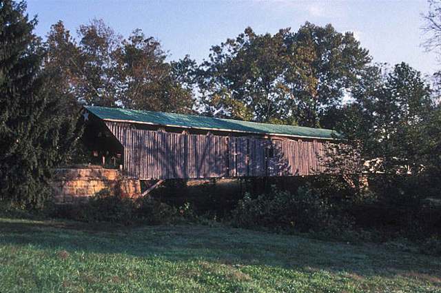
Photo: Jerrye and Roy Klotz, MD, Wikimedia Commons, CC BY-SA 4.0 · Wikimedia Commons
Local history sources: en.wikipedia.org · en.wikipedia.org · en.wikipedia.org
Historic places
1 place in Otway on the National Register of Historic Places. Press a pin or a name for its whole record.
-
Otway Covered BridgeSite · Otway · listed 1974
- Address
- N of OH 348
- Where
- Otway, Scioto County · ZIP 45657
- What it is
- Site
- Listed on the National Register
- 1974
- NRIS reference number
- 74002280
- Coordinates
- 38.86275, -83.18994
National Register file (NPS) ↗ Search Wikipedia ↗ Street map and directions ↗ On the Cracked Buckeye map
Source: National Park Service, National Register of Historic Places point file. The listing year is shown where NPS's certification date agrees with the listing's reference number. Listing recognizes significance; it does not restrict a private owner.
Water
No water-system data is linked to Otway's ZIP codes yet.
Hospitals, fire stations and more
Inside Otway's boundary: 1 fire or EMS station. Press a pin or a name for its whole record and its source.
Fire and EMS stations (1)
-
Otway Fire DepartmentOtway
- Address
- 6030 State Highway 73, Otway, OH 45657
- Coordinates
- 38.86454, -83.18778
USGS National Map structures (source) ↗ Street map and directions ↗
Source: USGS National Map structures (most Ohio records last updated 2019 to 2022), checked against the Columbus and Cleveland station lists. The department that answers a call is set by jurisdiction and mutual aid, not by distance.
Its ZIP codes
Each ZIP code that touches Otway, with the share of its residents who live here and the same headline figures as the ZIP page.
| ZIP | Share | Water | Radon | Home value | Schools | Flood |
|---|---|---|---|---|---|---|
| 45657 Brush Creek Township and Otway | 4% | Mostly private wells | Too few radon tests | Median year built 1980 | Northwest Local · 4 stars overall | 3.6% of residents in the 1% floodplain |
Local government
Who holds office in Otway, how its elections and ballot issues came out, and the state auditor's record.
Ballot issues
| Date | Issue | For | Against | Result |
|---|---|---|---|---|
| 2023-11-07 | Issue: OTWAY VILLAGE - FIRE PROTECTION | 24 | 12 | Passed (66.67% for) |
| 2020-11-03 | Issue: OTWAY VILLAGE CURRENT EXPENSE | 31 | 8 | Passed (79.49% for) |
| 2020-03-17 | Issue: Village Of Otway for the purpose of current expenses | 18 | 8 | Passed (69.23% for) |
| 2018-11-06 | Issue: Otway Village Fire | 18 | 11 | Passed (62.07% for) |
| 2015-11-03 | Issue: Otway Vill Current Expense | 27 | 10 | Passed (72.97% for) |
Elections for office
| Date | Office | Candidates and votes |
|---|---|---|
| 2023-11-07 | MAYOR | Denise Rose 27, 100.0% |
| 2017-11-07 | Council Member | Cheryl Pierce 19, 100.0% |
| 2015-11-03 | Mayor | Denise M. Rose 26, 100.0% |
| 2015-11-03 | Council Member | Lillie M. Crisp 19, 27.14%; Amy Eichenlaub 15, 21.43%; Michael W. Eichenlau 12, 17.14%; Anita Tolle Powell 24, 34.29% |
Winners in bold. Results from the county board of elections' official canvass unless marked.
Auditor of State record
- No fiscal caution, watch or emergency on the Auditor of State's lists.
- Financial Audit, 2023 to 2024, released 2026-05-26
The county
Scioto County: 15 ZIP codes, 24 cities, villages and townships, 75,725 people.
Nearby places
Rain and snow
How much has actually fallen on Otway, day by day, from 1893 to now. Daily totals, not averages.
- rain, last 30 days
- 1.52 in
- 2026-10-01 to 2026-10-30
- rain so far in 2026
- 37.6 in
- about normal for the date
- snow so far in 2026
- 15.7 in
- a normal year brings 15.8 in
- a normal year
- 44.3 in
- average of 30 years, 1991-2020
| Month | Rain (in) | Snow (in) | Days counted |
|---|---|---|---|
| October 2026 | 1.52 | — | 30 |
| September 2026 | 5.65 | — | 30 |
| August 2026 | 5.04 | — | 31 |
| July 2026 | 4.33 | — | 31 |
| June 2026 | 3.65 | — | 30 |
| May 2026 | 6.61 | — | 31 |
| April 2026 | 2.62 | — | 30 |
| March 2026 | 5.25 | 0.5 | 31 |
| February 2026 | 1.09 | 7.2 | 28 |
| January 2026 | 1.82 | 8.0 | 31 |
| December 2025 | 2.19 | 8.7 | 31 |
| November 2025 | 3.56 | 1.9 | 30 |
| Wettest year | 2018 — 60.8 in |
|---|---|
| Driest year | 1930 — 25.4 in |
| Snowiest year | 1917 — 48.6 in |
| Wettest day on record | 2 March 1997 — 4.28 in |
| Heaviest snowfall in a day | 17 January 1994 — 13.34 in |
| Deepest snow on the ground | 4 February 1907 — 23.90 in |
Estimated, not measured. No rain gauge has ever stood inside Otway, so every figure here is worked out from the gauges around it - the nearest ones weighted most. Treat them as close estimates rather than readings.
48,598 days of records, 1893-01-01 to 2026-10-30. Source: NOAA NCEI GHCN-Daily, 3,240 gauges in and around Ohio. A day is "gauged" when a gauge standing inside the boundary reported it, and the value is the mean of those gauges. Otherwise it is interpolated by inverse distance from every gauge reporting within 50 miles. Nothing is carried forward, back-filled or smoothed. Against NOAA nClimDiv county monthly precipitation over 136,848 complete county-months (checked 2026-11-01): correlation 0.9515, median absolute difference 0.217 in a month. Built 2026-11-01 from the Cracked Buckeye precipitation archive. Snow is the softer number — snowfall is measured by hand with a ruler, no agency publishes a gridded county snowfall series, and blowing snow defeats every observer.
Environmental permits and filings
What Ohio EPA has on file for Otway: permits, inspections, violations, cleanups and the state loans behind sewer and water work. Every line links to the agency's own document.
- facilities and sites on file
- 1
- those placed on the map inside Otway
| Program | Facilities and sites |
|---|---|
| Brownfield | 1 |
| Date | Facility or site | What |
|---|---|---|
| OTWAY SCHOOL | Brownfield assessment | |
| OTWAY SCHOOL | Brownfield assessment | |
| OTWAY SCHOOL | Brownfield assessment | |
| OTWAY SCHOOL | Brownfield assessment | |
| OTWAY SCHOOL | Brownfield assessment | |
| OTWAY SCHOOL | Brownfield assessment |
Source: Ohio EPA eDocument portal (edocpub.epa.ohio.gov), indexed 2026-10-14. Facilities are placed on the map from Ohio EPA's own map layers, EPA's Facility Registry, coordinates written in the filings, or a geocoded street address. A permit filed under a private person's name (most are household septic systems) is counted but never named, placed or linked; licenses for individual workers and open-burning notices are left out entirely.
Quick answers
What county is Otway, Ohio in?
Otway is a village in Scioto County, Ohio, with 92 residents.
When was Otway, Ohio founded?
Otway was settled 1861 (post office); laid out 1884-03-29; incorporated 1890. Source
How did Otway, Ohio get its name?
Named after Thomas Otway, an English dramatist. Source
What ZIP code is Otway, Ohio?
Most of Otway is in ZIP code 45657.
Where does Otway, Ohio get its water?
The main water source for Otway: Mostly private wells.
Cite this page
Cite this page as:
Cracked Buckeye, "Otway, Scioto County", https://crackedbuckeye.com/place/otway/, built 2026-10-31, accessed [date].
How to cite · Report a correction · Built 2026-10-31