Local events in Ottawa
7 events in the next 90 days from 1 public calendar. All local events in Ottawa
Checked October 20; the events page is refreshed daily.
History from Ottawa
People and inventions tied to this place, each with its sources. All people · All inventions
How Ottawa began
Ottawa, the Putnam County seat since 1866, is built on the Blanchard River site of Lower Tawa Town, an Ottawa (Odawa) Indian village that stood there until the 1831 cession and 1832 removal opened the ground to settlement. Euro-American settlement began around 1835, and the village incorporated in 1861, the first year of the Civil War. Its Beaux-Arts courthouse of 1912 and 1904 waterworks building, both on the National Register of Historic Places, anchor a downtown that still draws its water from the Blanchard River the Ottawa once lived beside.
Settled c. 1835, incorporated 1861.
Where the name comes from
Ottawa is named for the Ottawa (Odawa) people whose village, Lower Tawa Town, stood on the site before removal in 1831-32.
Before the town
Ottawa sits directly on the site of Lower Tawa Town, part of the Blanchard's Fork Reserve the Ottawa (Odawa) held under the 1817 Treaty of the Maumee Rapids (Fort Meigs) until their 1831 cession and 1832 removal to Kansas. In 1792, before the reserve was even created, Major Alexander Truman and William Lynch -- sent by President George Washington on a peace mission to the Native nations of the Northwest Indian War -- were killed at Lower Tawa Town; the Putnam County Courthouse now stands on that ground. Sources disagree over exactly which treaty provision fixed the Blanchard's Fork tract's boundary.
Nations recorded here: Odawa (Ottawa).
- Lower Tawa Town (village) — site of present downtown Ottawa, occupied Ottawa town by 1792; ceded 1831, vacated by 1832 (en.wikipedia.org)
Timeline
- — Major Alexander Truman and William Lynch are killed at Lower Tawa Town while carrying a peace overture from President George Washington, on ground later occupied by the Putnam County Courthouse.
- — The Treaty of the Maumee Rapids (Fort Meigs) establishes Ottawa reservations in northwest Ohio, including land along the Blanchard River at Lower Tawa Town.
- — The Ottawa cede the Blanchard's Fork Reserve and remove to Kansas, vacating Lower Tawa Town.
- — Henry Kohls, an early Euro-American settler, arrives in the area; his grandsons later served as Putnam County treasurers.
- — Ottawa incorporates as a village, in the first year of the Civil War.
- — The Putnam County seat transfers from Kalida to Ottawa.
- — The Ottawa Waterworks Building, a brick pumping station at 1035 E. Third Street, is built; it is listed on the National Register of Historic Places in 1976.
- — The current Putnam County Courthouse, designed by architect Frank Packard in the Beaux-Arts style, is completed in Ottawa; it is listed on the National Register of Historic Places in 1974.
- — The Ohio EPA completes a drinking water source assessment for Ottawa's intake on the Blanchard River.
Stories
A Village Built on a Village
When surveyors platted the town of Ottawa after 1831, they were not choosing empty ground. Lower Tawa Town, the Ottawa (Odawa) village that had stood on that exact bend of the Blanchard River since at least 1792, was gone only because its people had just been forced to cede the reserve and leave for Kansas. The new county seat took the departed nation's own name and grew over their old town site, and today the Putnam County Courthouse -- a Beaux-Arts building finished in 1912 -- stands, by the documentary record, on almost the same ground where Major Alexander Truman and William Lynch had been killed 120 years earlier while carrying a peace offer from President Washington to the Native nations fighting for that same river valley. Ottawa did not incorporate until 1861, thirty years after the cession, meaning the land sat through a full generation of Euro-American farming and platting before the village itself formally existed. Few Ohio county seats carry so direct and so well-documented a line from the nation whose name they took to the courthouse square that now occupies their former town.
Photographs
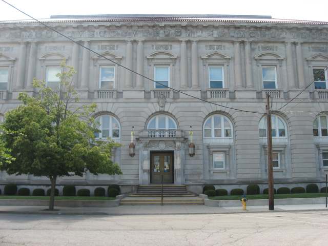
Photo: Nyttend, public domain · Wikimedia Commons
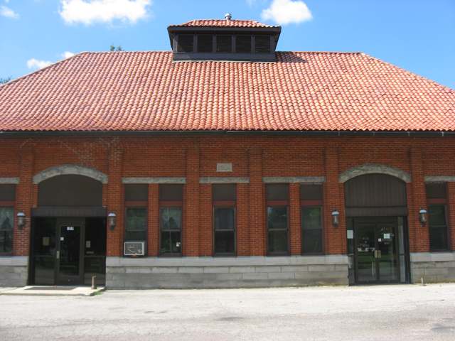
Photo: Nyttend, public domain · Wikimedia Commons
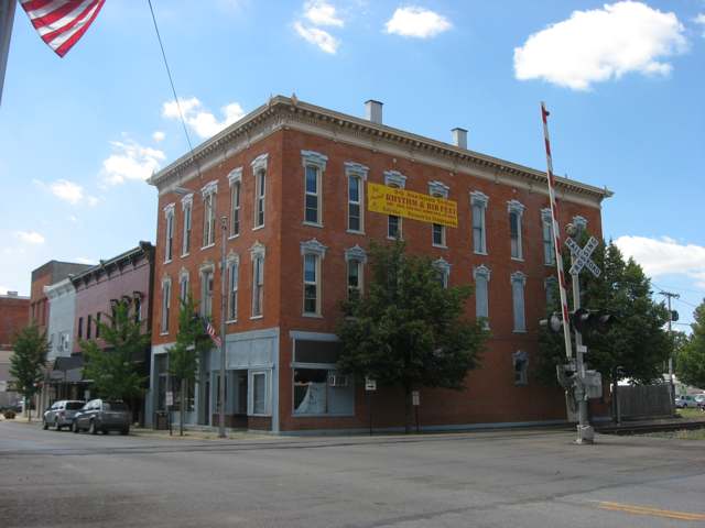
Photo: Nyttend, public domain · Wikimedia Commons
Local history sources: en.wikipedia.org · en.wikipedia.org · en.wikipedia.org · en.wikipedia.org · commons.wikimedia.org · commons.wikimedia.org · commons.wikimedia.org
Historic places
3 places in Ottawa on the National Register of Historic Places. Press a pin or a name for its whole record.
-
Huber, Dr. H., BlockBuilding · Ottawa · listed 1980
- Address
- Main St. and Taft Ave.
- Where
- Ottawa, Putnam County · ZIP 45875
- What it is
- Building
- Listed on the National Register
- 1980
- NRIS reference number
- 80003213
- Coordinates
- 41.01930, -84.04815
National Register file (NPS) ↗ Search Wikipedia ↗ Street map and directions ↗ On the Cracked Buckeye map
-
Ottawa Waterworks BuildingBuilding · Ottawa · listed 1976
- Address
- 1035 E. 3rd St.
- Where
- Ottawa, Putnam County · ZIP 45875
- What it is
- Building
- Listed on the National Register
- 1976
- NRIS reference number
- 76001519
- Coordinates
- 41.02152, -84.03652
National Register file (NPS) ↗ Search Wikipedia ↗ Street map and directions ↗ On the Cracked Buckeye map
-
Putnam County CourthouseBuilding · Ottawa · listed 1974
- Address
- Courthouse Sq.
- Where
- Ottawa, Putnam County · ZIP 45875
- What it is
- Building
- Listed on the National Register
- 1974
- NRIS reference number
- 74001608
- Coordinates
- 41.01979, -84.04623
National Register file (NPS) ↗ Search Wikipedia ↗ Street map and directions ↗ On the Cracked Buckeye map
Source: National Park Service, National Register of Historic Places point file. The listing year is shown where NPS's certification date agrees with the listing's reference number. Listing recognizes significance; it does not restrict a private owner.
Water
Mostly private wells The water here
- Ottawa Village84% of residentsBlanchard River (via intake reservoir)
- Glandorf Village16% of residentsBlanchard River (via intake reservoir)
Hospitals, fire stations and more
Inside Ottawa's boundary: 2 nursing homes, 3 fire and EMS stations, 1 power plant, 1 high-hazard dam, 2 public schools, 1 private school, 1 library, 2 police stations, 2 Superfund sites, 3 Toxics Release Inventory facilities and 8 spill cases. Press a pin or a name for its whole record and its source.
Nursing homes (2)
-
Autumn Court4 of 5 stars · Ottawa
- Address
- 1925 E Fourth St, Ottawa, OH 45875
- Certified beds
- 50
- Residents on an average day
- 47
- Medicare overall rating
- 4 of 5 stars
- Health inspections
- 3 of 5 stars
- Staffing
- 2 of 5 stars
- Quality measures
- 5 of 5 stars
- Penalties since 2023
- 1 fine totalling $25,495 (latest 2026-06-25)
- Ownership
- For profit - Corporation
- Chain
- LIONSTONE CARE
- Takes
- Medicare and Medicaid
- Phone
- (419) 523-4370
- Medicare ID
- 366217
Medicare Care Compare ↗ CMS nursing home data (source) ↗ Street map and directions ↗
-
Meadows of Ottawa The4 of 5 stars · Ottawa
- Address
- 147 Putnam Parkway, Ottawa, OH 45875
- Certified beds
- 86
- Residents on an average day
- 80
- Medicare overall rating
- 4 of 5 stars
- Health inspections
- 3 of 5 stars
- Staffing
- 3 of 5 stars
- Quality measures
- 5 of 5 stars
- Penalties since 2023
- none
- Ownership
- For profit - Corporation
- Chain
- TRILOGY HEALTH SERVICES
- Takes
- Medicare and Medicaid
- Phone
- (419) 523-4092
- Medicare ID
- 366423
Medicare Care Compare ↗ CMS nursing home data (source) ↗ Street map and directions ↗
Source: CMS Care Compare nursing home provider and penalties files; Medicare star ratings run 1 to 5.
Fire and EMS stations (3)
-
Ottawa Volunteer Fire Department Station 100Ottawa
- Address
- 850 North Agner Street, Ottawa, OH 45875
- Coordinates
- 41.02793, -84.03178
USGS National Map structures (source) ↗ Street map and directions ↗
-
Ottawa Volunteer Fire Department Station 101Ottawa
- Address
- 136 North Oak Street, Ottawa, OH 45875
- Coordinates
- 41.02003, -84.04669
USGS National Map structures (source) ↗ Street map and directions ↗
-
Ottawa Volunteer Fire Department Station 102Ottawa
- Address
- 305 North Taft Street, Ottawa, OH 45875
- Coordinates
- 41.02173, -84.04800
USGS National Map structures (source) ↗ Street map and directions ↗
Source: USGS National Map structures (most Ohio records last updated 2019 to 2022), checked against the Columbus and Cleveland station lists. The department that answers a call is set by jurisdiction and mutual aid, not by distance.
Power plants (1)
-
Whirlpool Corporation - Ottawa Wind FarmWind · 2 MW
- Capacity
- 2 MW
- Main source
- Wind
- Technology
- Onshore Wind Turbine
- Operator
- OEE XXIV LLC
- Sector
- Industrial Non-CHP
- Where
- Ottawa, Putnam County
- Generating units
- 1
- Built
- 2018
- EIA plant code
- 61004
EIA plant page ↗ EIA-860 (source) ↗ Street map and directions ↗
Source: EIA-860 power plant inventory via HIFLD (February 2025), with plant codes, units and years from EIA-860 2025.
High-hazard dams (1)
-
Ottawa Upground ReservoirBlanchard River - Offstream · condition: fair
- Hazard class
- High: a failure would probably cost a life
- Condition
- Fair (assessed 09/19/2019)
- River or stream
- Blanchard River - Offstream
- Purpose
- Water Supply
- Type
- Earth
- Height
- 22 ft
- Storage
- 400 acre-feet
- Completed
- 1972
- Owner type
- Local Government
- County
- Putnam County
- Nearest town (NID)
- Ottawa
- Last inspection
- 12/12/2024
- Emergency action plan
- Yes
- NID ID
- OH01058
National Inventory of Dams record ↗ National Inventory of Dams (source) ↗ Street map and directions ↗
Source: U.S. Army Corps of Engineers National Inventory of Dams, August 2026. "High hazard" rates what a failure would cost downstream, not how likely one is; the condition is the state's assessment.
Public schools (2)
-
Ottawa Elementary School4 of 5 stars · Ottawa
- Address
- 123 Putnam Pkwy, Ottawa, OH 45875
- School district
- Ottawa-Glandorf Local School District
- Kind (NCES)
- Regular School
- Students, 2023-24
- 398
- Teachers (full-time equivalent)
- 25.3
- Report card, 2025-26
- 4 of 5 stars
- Performance index
- 86.6%
- Ohio building IRN
- 028878
- NCES school ID
- 390493703573
NCES school record ↗ Ohio School Report Card ↗ Street map and directions ↗
-
Ottawa-Glandorf High School4.5 of 5 stars · Ottawa
- Address
- 630 Glendale Ave, Ottawa, OH 45875
- School district
- Ottawa-Glandorf Local School District
- Kind (NCES)
- Regular School
- Students, 2023-24
- 564
- Teachers (full-time equivalent)
- 27.83
- Report card, 2025-26
- 4.5 of 5 stars
- Performance index
- 86.8%
- Four-year graduation rate
- 97.7%
- Ohio building IRN
- 028910
- NCES school ID
- 390493703574
NCES school record ↗ Ohio School Report Card ↗ Street map and directions ↗
Source: NCES EDGE public school locations 2024-25 and Common Core of Data 2023-24 (type, students, teachers); Ohio School Report Cards 2025-26 (Department of Education and Workforce), matched by name within the district.
Private schools (1)
-
Sts Peter & Paul Catholic SchoolPrivate, Catholic · Ottawa
- Address
- 320 N Locust St, Ottawa, OH 45875
- Kind
- Catholic
- Students, 2023-24
- 312
- Teachers (full-time equivalent)
- 24.1
- Students per teacher
- 12.9461
- Phone
- (419) 523-3697
- NCES private school ID
- 01060579
Source: NCES Private School Survey 2023-24.
Public libraries (1)
-
Putnam County District LibraryCentral library · Ottawa
- Address
- 136 Putnam Parkway, Ottawa, OH 45875
- What it is
- Central library
- Library system
- Putnam County District Library
- Open
- 2,132 hours a year, 52 weeks
- Building
- 17,616 sq ft
- System's visits, FY2024
- 103,896
- System's loans, FY2024
- 236,789
- People the system serves
- 34,378
- Phone
- (419) 523-3747
IMLS Public Libraries Survey (source) ↗ Street map and directions ↗
Source: IMLS Public Libraries Survey FY2024 (outlets and their systems). Any Ohio resident can get a free card at any Ohio public library.
Police stations (2)
-
Ottawa Police DepartmentOttawa
- Address
- 136 North Oak Street, Ottawa, OH 45875
- Coordinates
- 41.01986, -84.04686
USGS National Map structures (source) ↗ Street map and directions ↗
-
Putnam County Sheriff's OfficeOttawa
- Address
- 1035 Heritage Trail, Ottawa, OH 45875
- Coordinates
- 41.00575, -84.03925
USGS National Map structures (source) ↗ Street map and directions ↗
Source: USGS National Map structures, police stations, corrected and completed by hand (September 2026). The department that answers a call is set by jurisdiction, not by distance.
Superfund sites (2)
-
Ottawa Lead SiteSuperfund program · Ottawa
- Address
- 440 E Second Street, Ottawa, OH 45875
- County
- Putnam County
- Status
- Superfund program site, not on the National Priorities List
- EPA program ID
- OHN000510386
- EPA registry ID
- 110039512168
EPA facility record ↗ EPA Facility Registry Service (source) ↗ Street map and directions ↗
-
Philips Display ComponentsSuperfund program · Ottawa
- Address
- 700 North Draft Street, Ottawa, OH 45875
- County
- Putnam County
- Status
- Superfund program site, not on the National Priorities List
- EPA program ID
- OHD038703484
- EPA registry ID
- 110067350495
EPA facility record ↗ EPA Facility Registry Service (source) ↗ Street map and directions ↗
Source: EPA Facility Registry Service, Superfund (SEMS) and National Priorities List sites. Many program sites were assessed and needed no cleanup.
Facilities reporting toxic releases (3)
-
L.G. Phillips Displays Usa, Inc.Toxics Release Inventory · Ottawa
- Address
- 700 North Pratt Street, Ottawa, OH 45875
- County
- Putnam County
- Status
- Reports to the Toxics Release Inventory (active)
- EPA program ID
- 45875PHLPS700NO
- EPA registry ID
- 110000395876
EPA facility record ↗ EPA Facility Registry Service (source) ↗ Street map and directions ↗
-
Steel Technologies LlcToxics Release Inventory · Ottawa
- Address
- 740 Williamstown Rd., Ottawa, OH 45875
- County
- Putnam County
- Status
- Reports to the Toxics Release Inventory (active)
- EPA program ID
- 45875CLDMT740WI
- EPA registry ID
- 110000395867
EPA facility record ↗ EPA Facility Registry Service (source) ↗ Street map and directions ↗
-
Whirlpool Corp. Ottawa OhioToxics Release Inventory · Ottawa
- Address
- 677 Woodland Dr, Ottawa, OH 45875
- County
- Putnam County
- Status
- Reports to the Toxics Release Inventory (active)
- EPA program ID
- 45875WCWDC9444W
- EPA registry ID
- 110000395885
EPA facility record ↗ EPA Facility Registry Service (source) ↗ Street map and directions ↗
Source: EPA Facility Registry Service, Toxics Release Inventory reporters. Reporting a release is required of large users of listed chemicals; it is not by itself a violation.
Spills reported since 2021 (8)
-
Other / All Other / Trade Name / Mixture / Solution Etc2025-12-01 · Ottawa
- Reported
- 2025-12-01
- What spilled
- Other / All Other / Trade Name / Mixture / Solution Etc
- Where
- Ottawa, Putnam County
- Ohio EPA district office
- NWDO
- Ohio EPA case number
- 2512EPA0001951
Ohio EPA spill reports (source) ↗ Street map and directions ↗
-
Oil Hydraulic Fluid(S) Reached water2025-08-09 · Ottawa
- Reported
- 2025-08-09
- What spilled
- Oil Hydraulic Fluid(S)
- Reached a waterway
- 62 - Lake Erie
- Where
- Ottawa, Ottawa County
- Ohio EPA district office
- NWDO
- Ohio EPA case number
- 2508EPA0001342
Ohio EPA spill reports (source) ↗ Street map and directions ↗
-
Manure Dairy2025-06-05 · Ottawa
- Reported
- 2025-06-05
- What spilled
- Manure Dairy
- Where
- Ottawa, Putnam County
- Ohio EPA district office
- NWDO
- Ohio EPA case number
- 2506EPA0000921
Ohio EPA spill reports (source) ↗ Street map and directions ↗
-
Sewage Sludge / Biosolids2024-05-02 · Ottawa
- Reported
- 2024-05-02
- What spilled
- Sewage Sludge / Biosolids
- Largest amount reported
- 5,000 gallons
- Where
- Ottawa, Putnam County
- Ohio EPA district office
- NWDO
- Ohio EPA case number
- 2405EPA0000726
Ohio EPA spill reports (source) ↗ Street map and directions ↗
-
Waste Water2024-04-05 · Ottawa
- Reported
- 2024-04-05
- What spilled
- Waste Water
- Largest amount reported
- 10,000 gallons
- Where
- Ottawa, Putnam County
- Ohio EPA district office
- NWDO
- Ohio EPA case number
- 2404EPA0000535
Ohio EPA spill reports (source) ↗ Street map and directions ↗
-
Fuel Gasoline ( 25% Ethanol Not E85)2022-03-17 · Ottawa
- Reported
- 2022-03-17
- What spilled
- Fuel Gasoline ( 25% Ethanol Not E85)
- Largest amount reported
- 10 gallons
- Where
- Ottawa, Putnam County
- Ohio EPA district office
- NWDO
- Ohio EPA case number
- 2203EPA0000351
Ohio EPA spill reports (source) ↗ Street map and directions ↗
-
Fuel Diesel / Diesel Fuel (Vehicle On Or Off Road)2022-02-10 · Ottawa
- Reported
- 2022-02-10
- What spilled
- Fuel Diesel / Diesel Fuel (Vehicle On Or Off Road)
- Largest amount reported
- 15 gallons
- Where
- Ottawa, Putnam County
- Ohio EPA district office
- NWDO
- Ohio EPA case number
- 2202EPA0000161
Ohio EPA spill reports (source) ↗ Street map and directions ↗
-
Manure Nos (Not Specified) Reached water2021-02-04 · Ottawa
- Reported
- 2021-02-04
- What spilled
- Manure Nos (Not Specified)
- Reached a waterway
- 99 - Unnamed
- Where
- Ottawa, Putnam County
- Ohio EPA district office
- NWDO
- Ohio EPA case number
- 2102EPA0000164
Ohio EPA spill reports (source) ↗ Street map and directions ↗
Source: Ohio EPA emergency response spill reports, 2021 to September 2026, one point per case where Ohio EPA placed it. A report is what the caller or responder recorded; amounts are often blank or estimated.
Its ZIP codes
Each ZIP code that touches Ottawa, with the share of its residents who live here and the same headline figures as the ZIP page.
| ZIP | Share | Water | Radon | Home value | Schools | Flood |
|---|---|---|---|---|---|---|
| 45875 Ottawa | 40% | Mostly private wells | 2.5 pCi/L average radon | Median year built 1975 | Ottawa-Glandorf Local · 4 stars overall | 12% of residents in the 1% floodplain |
Local government
Who holds office in Ottawa, how its elections and ballot issues came out, and the state auditor's record.
Money issues on the ballot since 2021: 1 of 1 passed.
Ballot issues
| Date | Issue | For | Against | Result |
|---|---|---|---|---|
| 2021-11-02 | Issue: Ottawa Village (levy type not on the results report) | 385 | 74 | Passed (83.88% for) |
Elections for office
| Date | Office | Candidates and votes |
|---|---|---|
| 2023-11-07 | Member of Council | Matt Black 1,026, 32.19%; Chad Brinkman 1,086, 34.08%; Jo A. Deskins 1,075, 33.73% |
| 2021-11-02 | Member of Council | Timothy J. Maag 357, 35.31%; David L. Michel 323, 31.95%; Thomas Rosenbauer 331, 32.74% |
| 2019-11-05 | Member of Council (unofficial count) | Matthew D. Black 508, 24.78%; Jo A. Deskins 573, 27.95%; A. Jeff Ducey 511, 24.93%; Troy D. Yant 458, 22.34% |
| 2019-11-05 | Mayor (unofficial count) | J. Dean Meyer 711, 100.0% |
| 2017-11-07 | Member of Council (unofficial count) | Tim Maag 751, 35.86%; David L. Michel 708, 33.81%; Thomas Rosenbauer 635, 30.32% |
| 2015-11-03 | Member of Council (unofficial count) | Jo A. Deskins 959, 33.4%; Jeff Ducey 1,033, 35.98%; Troy D. Yant 879, 30.62% |
Winners in bold. Results from the county board of elections' official canvass unless marked.
Auditor of State record
- No fiscal caution, watch or emergency on the Auditor of State's lists.
- Financial Audit, 2024, released 2026-01-08
- Financial Audit, 2023, released 2024-10-22
The county
Putnam County: 13 ZIP codes, 31 cities, villages and townships, 35,849 people.
Nearby places
Rain and snow
How much has actually fallen on Ottawa, day by day, from 1893 to now. Daily totals, not averages.
- rain, last 30 days
- 0.75 in
- 2026-10-01 to 2026-10-30
- rain so far in 2026
- 33.9 in
- about normal for the date
- snow so far in 2026
- 18.4 in
- a normal year brings 19.3 in
- a normal year
- 39.1 in
- average of 30 years, 1991-2020
| Month | Rain (in) | Snow (in) | Days counted |
|---|---|---|---|
| October 2026 | 0.75 | — | 30 |
| September 2026 | 3.38 | — | 30 |
| August 2026 | 5.97 | — | 31 |
| July 2026 | 4.23 | — | 31 |
| June 2026 | 4.41 | — | 30 |
| May 2026 | 4.03 | — | 31 |
| April 2026 | 5.52 | — | 30 |
| March 2026 | 3.80 | 1.0 | 31 |
| February 2026 | 0.91 | 3.1 | 28 |
| January 2026 | 0.95 | 14.3 | 31 |
| December 2025 | 1.56 | 7.8 | 31 |
| November 2025 | 1.27 | 4.5 | 30 |
| Wettest year | 2011 — 54.5 in |
|---|---|
| Driest year | 1960 — 22.7 in |
| Snowiest year | 1895 — 55.4 in |
| Wettest day on record | 19 August 2007 — 8.14 in |
| Heaviest snowfall in a day | 12 January 1895 — 12.27 in |
| Deepest snow on the ground | 2 March 1912 — 20.20 in |
44% of these days are measurements from a gauge inside Ottawa; the rest are estimated from the nearest gauges around it.
48,863 days of records, 1893-01-01 to 2026-10-30. Source: NOAA NCEI GHCN-Daily, 3,240 gauges in and around Ohio. A day is "gauged" when a gauge standing inside the boundary reported it, and the value is the mean of those gauges. Otherwise it is interpolated by inverse distance from every gauge reporting within 50 miles. Nothing is carried forward, back-filled or smoothed. Against NOAA nClimDiv county monthly precipitation over 136,848 complete county-months (checked 2026-11-01): correlation 0.9515, median absolute difference 0.217 in a month. Built 2026-11-01 from the Cracked Buckeye precipitation archive. Snow is the softer number — snowfall is measured by hand with a ruler, no agency publishes a gridded county snowfall series, and blowing snow defeats every observer.
Environmental permits and filings
What Ohio EPA has on file for Ottawa: permits, inspections, violations, cleanups and the state loans behind sewer and water work. Every line links to the agency's own document.
- facilities and sites on file
- 48
- those placed on the map inside Ottawa
| Program | Facilities and sites |
|---|---|
| Voluntary cleanup | 11 |
| Hazardous waste | 9 |
| Air pollution | 5 |
| Sewer and water-line construction | 5 |
| State water loans | 4 |
| Wastewater and stormwater discharge | 4 |
| Public drinking water | 3 |
| State sewer loans | 3 |
| Composting | 2 |
| Cessation Of Regulated Operations | 1 |
| Contaminated-site cleanup | 1 |
| Date | Facility or site | What |
|---|---|---|
| WHIRLPOOL CORP - OTTAWA DIV | Air pollution report | |
| OTTAWA VILLAGE PWS | Public drinking water inspection | |
| OTTAWA VILLAGE PWS | Public drinking water notice of violation | |
| OTTAWA VILLAGE PWS | Public drinking water director's orders | |
| OTTAWA VILLAGE PWS | Public drinking water compliance letter | |
| OTTAWA COMPOSTING FACILITY | Composting inspection | |
| OTTAWA VILLAGE PWS | Public drinking water notice of violation | |
| OTTAWA VILLAGE PWS | Public drinking water plan | |
| OTTAWA VILLAGE PWS | Public drinking water inspection | |
| OTTAWA VILLAGE PWS | Public drinking water report | |
| GLANDORF VILLAGE WATER PWS | Public drinking water report | |
| 4011 - SUGAR AND WEST 3RD | Wastewater and stormwater discharge permit | |
| OTTAWA VILLAGE PWS | Public drinking water inspection | |
| GLANDORF VILLAGE WATER PWS | Public drinking water compliance letter | |
| OTTAWA VILLAGE PWS | Public drinking water report | |
| OTTAWA VILLAGE PWS | Public drinking water inspection | |
| OTTAWA VILLAGE PWS | Public drinking water inspection | |
| OTTAWA VILLAGE PWS | Public drinking water notice of violation | |
| HIRZEL CANNING CO AND FARMS - OTTAWA FOODS DIV * | Air pollution report | |
| VERHOFF ALFALFA OTTAWA PLANT * | Air pollution report | |
| OTTAWA VILLAGE PWS | Public drinking water plan | |
| OTTAWA VILLAGE PWS | Public drinking water compliance letter | |
| LG PHILIPS DISPLAYS USA INC | Voluntary cleanup inspection | |
| OTTAWA VILLAGE PWS | Public drinking water inspection | |
| LG PHILIPS DISPLAYS USA INC | Voluntary cleanup inspection |
Source: Ohio EPA eDocument portal (edocpub.epa.ohio.gov), indexed 2026-10-14. Facilities are placed on the map from Ohio EPA's own map layers, EPA's Facility Registry, coordinates written in the filings, or a geocoded street address. A permit filed under a private person's name (most are household septic systems) is counted but never named, placed or linked; licenses for individual workers and open-burning notices are left out entirely.
Quick answers
What county is Ottawa, Ohio in?
Ottawa is a village in Putnam County, Ohio, with 4,456 residents.
When was Ottawa, Ohio founded?
Ottawa was settled c. 1835; incorporated 1861. Source
How did Ottawa, Ohio get its name?
Ottawa is named for the Ottawa (Odawa) people whose village, Lower Tawa Town, stood on the site before removal in 1831-32. Source
What ZIP code is Ottawa, Ohio?
Most of Ottawa is in ZIP code 45875.
Where does Ottawa, Ohio get its water?
The main water source for Ottawa (Ottawa Village): Mostly private wells.
Cite this page
Cite this page as:
Cracked Buckeye, "Ottawa, Putnam County", https://crackedbuckeye.com/place/ottawa/, built 2026-10-31, accessed [date].
How to cite · Report a correction · Built 2026-10-31