Local events in Glandorf
Nothing is posted for Glandorf itself yet; here is what is on within 20 miles. All local events in Glandorf
Know a calendar we should watch? Send the link
Checked October 20; the events page is refreshed daily.
How Glandorf began
Glandorf was founded in 1833-34 by Johann Wilhelm Horstmann and six fellow German emigrants from the town of Glandorf, Germany, who sailed from Amsterdam on the ship Columbus in September 1833 and bought Putnam County land that December; more families, including Horstmann's wife, followed in 1834. Horstmann built a combined log church, school, and rectory the same year, dedicated to St. John the Baptist; the congregation's current Neo-Gothic church, consecrated December 15, 1878, is listed on the National Register of Historic Places. A Precious Blood Sisters convent operated in the village from 1849 to 1917.
Settled 1833 (land purchased December 1833), by Johann Wilhelm Horstmann and six fellow German emigrants from Glandorf, Germany.
Where the name comes from
Glandorf kept the name of the German town of Glandorf from which its founding families emigrated in 1833.
Before the town
No Native American site or village specific to Glandorf was located in the sources checked. Glandorf lies within Ottawa Township, near the eastern edge of the former Blanchard's Fork Ottawa Reserve.
Nations recorded here: Odawa (Ottawa).
Timeline
- — Johann Wilhelm Horstmann and six fellow emigrants from Glandorf, Germany sail from Amsterdam on the ship Columbus.
- — The group lands in New York.
- — The settlers purchase Putnam County land.
- — Horstmann builds a combined log church, school, and rectory dedicated to St. John the Baptist; wives and ten additional families join the settlement.
- — A wooden church replaces the original log structure.
- — Johann Wilhelm Horstmann dies; his land passes to the community.
- — A brick church building replaces the wooden church.
- — A Precious Blood Sisters convent opens in Glandorf, operating until 1917.
- — The current Neo-Gothic St. John the Baptist church is erected and consecrated.
- — St. John the Baptist Roman Catholic Church is listed on the National Register of Historic Places.
Stories
A German Village Transplanted Whole
Glandorf is one of the more literal examples of chain migration in Putnam County's history: Johann Wilhelm Horstmann and six other men from the town of Glandorf in northwestern Germany sailed together from Amsterdam on the ship Columbus in September 1833, landed in New York that November, and by December had bought land in the recently opened Putnam County swampland -- naming their new settlement for the German town every one of them had left behind. They did not stay alone for long. Wives and ten more families followed within the year, and Horstmann's first act on the new ground was not a house but a single combined log building serving as church, school, and rectory at once, dedicated to St. John the Baptist. That congregation outgrew a wooden church by 1846 and a brick one by 1878, when the Neo-Gothic building that still stands today was consecrated -- a building substantial enough, in a farm village of German Catholic settlers, to anchor a Precious Blood Sisters convent from 1849 until 1917. Horstmann himself did not live to see the brick church: he died in 1843, leaving his land to the community he had founded less than a decade earlier.
Photographs
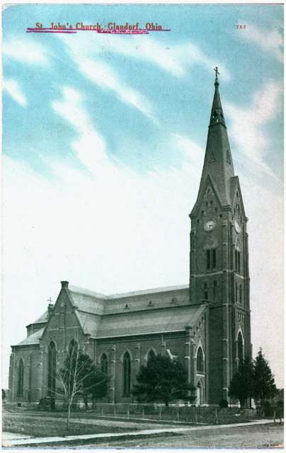
Photo: Columbus Metropolitan Library, via Digital Public Library of America, no known copyright restrictions · Wikimedia Commons
Local history sources: en.wikipedia.org · commons.wikimedia.org · en.wikipedia.org · en.wikipedia.org · en.wikipedia.org
Historic places
1 place in Glandorf on the National Register of Historic Places. Press a pin or a name for its whole record.
-
St. John The Baptist Roman Catholic ChurchBuilding · Glandorf · listed 1977
- Address
- OH 694 and Main St.
- Where
- Glandorf, Putnam County · ZIP 45848
- What it is
- Building
- Listed on the National Register
- 1977
- NRIS reference number
- 77001083
- Coordinates
- 41.03055, -84.07953
National Register file (NPS) ↗ Search Wikipedia ↗ Street map and directions ↗ On the Cracked Buckeye map
Source: National Park Service, National Register of Historic Places point file. The listing year is shown where NPS's certification date agrees with the listing's reference number. Listing recognizes significance; it does not restrict a private owner.
Water
Blanchard River (via intake reservoir) The water here
- Ottawa Village74% of residentsBlanchard River (via intake reservoir)
- Glandorf Village26% of residentsBlanchard River (via intake reservoir)
Hospitals, fire stations and more
Inside Glandorf's boundary: 1 dialysis center, 1 fire or EMS station and 1 public school. Press a pin or a name for its whole record and its source.
Dialysis centers (1)
-
Fmc-Putnam Cty Ambulatory Care Ctr-DialysisDialysis · Glandorf
- Address
- 601 State Rt 224, Glandorf, OH 45848
- Dialysis stations
- 12
- Medicare star rating
- 1 of 5 stars
- Services
- in-center hemodialysis
- Ownership
- for profit
- Chain
- Fresenius Medical Care
- Medicare certified since
- 2005-01-01
- Phone
- (567) 420-6048
- Medicare ID
- 362674
Medicare Care Compare ↗ CMS dialysis facility list (source) ↗ Street map and directions ↗
Source: CMS dialysis facility list, September 2026, geocoded with the Census Bureau batch geocoder (an address it could not place sits at its ZIP center).
Fire and EMS stations (1)
-
Glandorf Volunteer Fire DepartmentGlandorf
- Address
- 203 North Main Street, Glandorf, OH 45848
- Coordinates
- 41.03085, -84.08017
USGS National Map structures (source) ↗ Street map and directions ↗
Source: USGS National Map structures (most Ohio records last updated 2019 to 2022), checked against the Columbus and Cleveland station lists. The department that answers a call is set by jurisdiction and mutual aid, not by distance.
Public schools (1)
-
Glandorf Elementary School4 of 5 stars · Ottawa
- Address
- 140 Church St, Ottawa, OH 45875
- School district
- Ottawa-Glandorf Local School District
- Kind (NCES)
- Regular School
- Students, 2023-24
- 537
- Teachers (full-time equivalent)
- 32.73
- Report card, 2025-26
- 4 of 5 stars
- Performance index
- 91.9%
- Ohio building IRN
- 013508
- NCES school ID
- 390493703572
NCES school record ↗ Ohio School Report Card ↗ Street map and directions ↗
Source: NCES EDGE public school locations 2024-25 and Common Core of Data 2023-24 (type, students, teachers); Ohio School Report Cards 2025-26 (Department of Education and Workforce), matched by name within the district.
Its ZIP codes
Each ZIP code that touches Glandorf, with the share of its residents who live here and the same headline figures as the ZIP page.
| ZIP | Share | Water | Radon | Home value | Schools | Flood |
|---|---|---|---|---|---|---|
| 45848 Glandorf | 100% | Blanchard River (via intake reservoir) | Too few radon tests | Median year built 1952 | Ottawa-Glandorf Local · 4 stars overall | 98% of residents in the 1% floodplain |
| 45875 Ottawa | 8% | Mostly private wells | 2.5 pCi/L average radon | Median year built 1975 | Ottawa-Glandorf Local · 4 stars overall | 12% of residents in the 1% floodplain |
Local government
Who holds office in Glandorf, how its elections and ballot issues came out, and the state auditor's record.
Money issues on the ballot since 2023: 1 of 1 passed.
Ballot issues
| Date | Issue | For | Against | Result |
|---|---|---|---|---|
| 2023-11-07 | Issue: Proposed Tax Levy (Renewal) - Glandorf Village | 364 | 161 | Passed (69.33% for) |
Elections for office
| Date | Office | Candidates and votes |
|---|---|---|
| 2023-11-07 | Member of Council | Scott Buckland 331, 35.67%; Travis Duling 240, 25.86%; Brian J. Inkrott 357, 38.47% |
| 2023-11-07 | Member of Board of Public Affairs | Derrick Schierloh 418, 51.99%; Brian Seimet 386, 48.01% |
| 2021-11-02 | Member of Council | Kristen M. Gerding-Heffner 118, 25.16%; Zach Klausing 110, 23.45%; Doug C. Trombley 120, 25.59%; Dale J. Warnecke 121, 25.8% |
| 2021-11-02 | Member of Board of Public Affairs | Christopher Recker 124, 100.0% |
| 2019-11-05 | Member of Council (unofficial count) | Scott Buckland 191, 47.75%; Brian J. Inkrott 209, 52.25% |
| 2019-11-05 | Member of Board of Public Affairs (unofficial count) | Thomas R. Schroeder 181, 47.01%; Brian Seimet 204, 52.99% |
| 2019-11-05 | Mayor (unofficial count) | Charles Schroeder 220, 100.0% |
| 2017-11-07 | Member of Council (unofficial count) | Eric Thomas Kaufman 259, 30.8%; Charlie Schroeder 266, 31.63%; Dale J. Warnecke 279, 33.17%; WRITE-IN 37, 4.4% |
| 2015-11-03 | Member of Council (unofficial count) | Scott Buckland 305, 46.64%; Brian Inkrott 349, 53.36% |
| 2015-11-03 | Member of Board of Public Affairs (unofficial count) | Thomas R. Schroeder 290, 45.38%; Doug Trombley 349, 54.62% |
Winners in bold. Results from the county board of elections' official canvass unless marked.
Auditor of State record
- No fiscal caution, watch or emergency on the Auditor of State's lists.
- Financial Audit, 2023 to 2024, released 2025-12-30
The county
Putnam County: 13 ZIP codes, 31 cities, villages and townships, 35,849 people.
Nearby places
Rain and snow
How much has actually fallen on Glandorf, day by day, from 1893 to now. Daily totals, not averages.
- rain, last 30 days
- 0.73 in
- 2026-09-30 to 2026-10-29
- rain so far in 2026
- 34.4 in
- about normal for the date
- snow so far in 2026
- 15.8 in
- a normal year brings 19.4 in
- a normal year
- 39.2 in
- average of 30 years, 1991-2020
| Month | Rain (in) | Snow (in) | Days counted |
|---|---|---|---|
| October 2026 | 0.73 | — | 29 |
| September 2026 | 3.37 | — | 30 |
| August 2026 | 6.01 | — | 31 |
| July 2026 | 4.37 | — | 31 |
| June 2026 | 4.26 | — | 30 |
| May 2026 | 3.95 | — | 31 |
| April 2026 | 5.37 | — | 30 |
| March 2026 | 4.38 | 1.0 | 31 |
| February 2026 | 0.98 | 2.7 | 28 |
| January 2026 | 1.01 | 12.0 | 31 |
| December 2025 | 1.63 | 7.5 | 31 |
| November 2025 | 1.21 | 5.2 | 30 |
| Wettest year | 1997 — 54.9 in |
|---|---|
| Driest year | 1960 — 21.8 in |
| Snowiest year | 1982 — 54.4 in |
| Wettest day on record | 19 August 2007 — 7.82 in |
| Heaviest snowfall in a day | 16 November 1932 — 11.44 in |
| Deepest snow on the ground | 15 January 1918 — 19.55 in |
Mostly estimated. Only 10% of these days come from a gauge standing inside Glandorf - the rest are worked out from the nearest gauges around it, so read them as close estimates rather than readings.
48,862 days of records, 1893-01-01 to 2026-10-29. Source: NOAA NCEI GHCN-Daily, 3,240 gauges in and around Ohio. A day is "gauged" when a gauge standing inside the boundary reported it, and the value is the mean of those gauges. Otherwise it is interpolated by inverse distance from every gauge reporting within 50 miles. Nothing is carried forward, back-filled or smoothed. Against NOAA nClimDiv county monthly precipitation over 136,848 complete county-months (checked 2026-10-31): correlation 0.9515, median absolute difference 0.217 in a month. Built 2026-10-31 from the Cracked Buckeye precipitation archive. Snow is the softer number — snowfall is measured by hand with a ruler, no agency publishes a gridded county snowfall series, and blowing snow defeats every observer.
Environmental permits and filings
What Ohio EPA has on file for Glandorf: permits, inspections, violations, cleanups and the state loans behind sewer and water work. Every line links to the agency's own document.
- facilities and sites on file
- 4
- those placed on the map inside Glandorf
| Program | Facilities and sites |
|---|---|
| Air pollution | 1 |
| Hazardous waste | 1 |
| Sewer and water-line construction | 1 |
| Wastewater and stormwater discharge | 1 |
| Date | Facility or site | What |
|---|---|---|
| WEIGAND CONSTRUCTION GLANDORF OFFICE | Wastewater and stormwater discharge permit | |
| GERALD GRAIN CENTER | Air pollution report | |
| THE VILLA SUBDIVISION | Sewer and water-line construction permit | |
| THE VILLA SUBDIVISION | Sewer and water-line construction permit | |
| GLANDORF FEED CO | Air pollution permit | |
| GLANDORF FEED CO | Air pollution permit | |
| GLANDORF FEED CO | Air pollution permit | |
| GLANDORF FEED CO | Air pollution permit |
Source: Ohio EPA eDocument portal (edocpub.epa.ohio.gov), indexed 2026-10-14. Facilities are placed on the map from Ohio EPA's own map layers, EPA's Facility Registry, coordinates written in the filings, or a geocoded street address. A permit filed under a private person's name (most are household septic systems) is counted but never named, placed or linked; licenses for individual workers and open-burning notices are left out entirely.
Quick answers
What county is Glandorf, Ohio in?
Glandorf is a village in Putnam County, Ohio, with 974 residents.
When was Glandorf, Ohio founded?
Glandorf was settled 1833 (land purchased December 1833). Founders on record: Johann Wilhelm Horstmann and six fellow German emigrants from Glandorf, Germany. Source
How did Glandorf, Ohio get its name?
Glandorf kept the name of the German town of Glandorf from which its founding families emigrated in 1833. Source
What ZIP code is Glandorf, Ohio?
Glandorf is served by ZIP codes 45848 and 45875; 45848 holds the largest share of its residents.
Where does Glandorf, Ohio get its water?
The main water source for Glandorf (Ottawa Village): Blanchard River (via intake reservoir).
Cite this page
Cite this page as:
Cracked Buckeye, "Glandorf, Putnam County", https://crackedbuckeye.com/place/glandorf/, built 2026-10-31, accessed [date].
How to cite · Report a correction · Built 2026-10-31
