Local events in Orrville
79 events in the next 90 days from 5 public calendars. All local events in Orrville
Checked October 20; the events page is refreshed daily.
History from Orrville
People and inventions tied to this place, each with its sources. All people · All inventions
Videos about Orrville
Short videos we made from the old maps and records. All videos
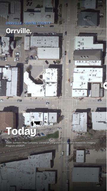
How Orrville began
Orrville was laid out in 1852 by Judge Smith Orr, together with Robert Taggard, on the strength of a new railroad line, and grew as a Wayne County rail town about nine miles east of Wooster. It is best known as the home of the J.M. Smucker Company, founded here in 1897 by Jerome Monroe Smucker selling apple butter from a horse-drawn wagon, which grew into a national fruit-spread manufacturer still headquartered in the city today. The city's economy has also included Smith Dairy Products and the Schantz Organ Company, a pipe-organ builder whose factory is listed on the National Register of Historic Places.
Platted 1852, by Judge Smith Orr and Robert Taggard.
Where the name comes from
Named for its proprietor, Judge Smith Orr, who platted the town in 1852; a post office under the Orrville name opened the same year.
Before the town
No Native American village, trail, mound or treaty event specific to the site of Orrville was found in the sources checked. The town was platted in 1852, decades after the Delaware, Wyandot and Shawnee presence recorded elsewhere in Wayne County had ended. The county's Native history includes the Delaware settlement on Killbuck Creek to the west.
Nations recorded here: Delaware (Lenape), Wyandot, Shawnee.
Timeline
- — Judge Smith Orr and Robert Taggard plat the new settlement of Orrville, timed to a new railroad line; a post office opens the same year.
- — Orrville's population is recorded at 745.
- — Jerome Monroe Smucker, born in Orrville in 1858, begins selling apple butter from a horse-drawn wagon, founding what becomes the J.M. Smucker Company.
- — Orrville's population reaches 3,101, a 63 percent increase over 1900.
- — The J.M. Smucker Company is incorporated.
- — Smucker's introduces its trademark glass jar for retail sale.
- — The J.M. Smucker Company lists on the New York Stock Exchange.
Stories
A wagon, a jar of apple butter, and a company that outgrew the town
Jerome Monroe Smucker was born in Orrville in December 1858 and, in 1897, began preparing apple butter and selling it door to door from the back of a horse-drawn wagon, using apples the company later said came from trees descended from stock planted by Johnny Appleseed in the early 1800s. What started as a one-man local business grew steadily: the company incorporated in 1921, expanded distribution into Pennsylvania and Indiana by 1928, opened a Washington state processing plant for its founder's eldest son Willard in 1935, and introduced the trademark glass jar that became a fixture of American pantries in 1939. National distribution followed in 1942, and by 1959 the company was large enough to go public, listing on the New York Stock Exchange in 1965. More than 125 years after Jerome Smucker's first wagon route, the J.M. Smucker Company remains headquartered in Orrville, now run by his descendant Mark Smucker, and operates what the company describes as the world's largest fruit-spread production facility in the small city where it began.
Photographs
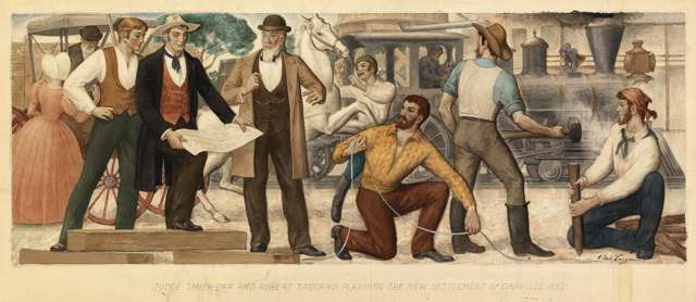
Photo: Aldo Lazzarini / Smithsonian American Art Museum, public domain · Wikimedia Commons
Local history sources: en.wikipedia.org · en.wikipedia.org · en.wikipedia.org · commons.wikimedia.org
Historic places
3 places in Orrville on the National Register of Historic Places. Press a pin or a name for its whole record.
-
Barnet-Hoover Log HouseBuilding · Orrville · listed 1974
- Address
- NW of Orrville
- Where
- Orrville, Wayne County · ZIP 44667
- What it is
- Building
- Listed on the National Register
- 1974
- NRIS reference number
- 74001648
- Coordinates
- 40.86110, -81.78877
National Register file (NPS) ↗ Search Wikipedia ↗ Street map and directions ↗ On the Cracked Buckeye map
-
Schantz Organ CompanyBuilding · Orrville
- Address
- 626 South Walnut St.
- Where
- Orrville, Wayne County · ZIP 44667
- What it is
- Building
- Latest NPS certification action
- 2021
- NRIS reference number
- 100006818
- Coordinates
- 40.83483, -81.76304
National Register file (NPS) ↗ Search Wikipedia ↗ Street map and directions ↗ On the Cracked Buckeye map
-
Smith Orr HomesteadBuilding · Orrville · listed 2011
- Address
- Market St. roughly between High & Main
- Where
- Orrville, Wayne County · ZIP 44667
- What it is
- Building
- Listed on the National Register
- 2011
- NRIS reference number
- 11000370
- Coordinates
- 40.84199, -81.76803
National Register file (NPS) ↗ Search Wikipedia ↗ Street map and directions ↗ On the Cracked Buckeye map
Source: National Park Service, National Register of Historic Places point file. The listing year is shown where NPS's certification date agrees with the listing's reference number. Listing recognizes significance; it does not restrict a private owner.
Water
Local groundwater wells (Wayne County) The water here
- Orrville City98% of residentsLocal groundwater wells (Wayne County)
- Millborne Mobile Home Community1% of residentsGroundwater wells (1 wells)
- Little Chippewa Estates1% of residentsGroundwater wells (1 wells)
- Glenridge Mobile Home Park0% of residentsGroundwater wells (2 wells)
Hospitals, fire stations and more
Inside Orrville's boundary: 1 hospital, 2 nursing homes, 2 fire and EMS stations, 1 college, 3 power plants, 4 public schools, 1 library, 2 museums, 1 police station, 28 Toxics Release Inventory facilities and 12 spill cases. Press a pin or a name for its whole record and its source.
Hospitals (1)
-
Aultman Orrville HospitalCritical access hospital · Orrville
- What it is
- Critical access hospital
- Address
- 832 South Main Street, Orrville, OH 44667
- County
- Wayne County
- Beds
- 37
- Helipad
- Yes
- Ownership
- Non-profit
- Medicare overall rating
- not rated
- Emergency department (Medicare)
- Yes
- Phone
- (330) 682-3010
- Medicare ID
- 361323
Medicare Care Compare ↗ Hospital's website ↗ Where HIFLD got this record ↗ HIFLD hospitals (source) ↗ Street map and directions ↗
Source: HIFLD hospitals inventory via FEMA (closed hospitals it still lists left out, hospitals opened since added), with Medicare Care Compare ratings matched by name and address.
Nursing homes (2)
-
Accord Care Community Orrville Llc2 of 5 stars · Orrville
- Address
- 1980 Lynn Drive, Orrville, OH 44667
- Certified beds
- 88
- Residents on an average day
- 59
- Medicare overall rating
- 2 of 5 stars
- Health inspections
- 2 of 5 stars
- Staffing
- 1 of 5 stars
- Quality measures
- 5 of 5 stars
- Penalties since 2023
- none
- Ownership
- For profit - Limited Liability company
- Takes
- Medicare and Medicaid
- Phone
- (330) 683-4075
- Medicare ID
- 366123
Medicare Care Compare ↗ CMS nursing home data (source) ↗ Street map and directions ↗
-
Orrville Pointe2 of 5 stars · Orrville
- Address
- 230 South Crown Hill Road, Orrville, OH 44667
- Certified beds
- 47
- Residents on an average day
- 45
- Medicare overall rating
- 2 of 5 stars
- Health inspections
- 1 of 5 stars
- Staffing
- 1 of 5 stars
- Quality measures
- 5 of 5 stars
- Penalties since 2023
- none
- Ownership
- For profit - Limited Liability company
- Chain
- JAG HEALTHCARE
- Takes
- Medicare and Medicaid
- Phone
- (330) 682-2273
- Medicare ID
- 366203
Medicare Care Compare ↗ CMS nursing home data (source) ↗ Street map and directions ↗
Source: CMS Care Compare nursing home provider and penalties files; Medicare star ratings run 1 to 5.
Fire and EMS stations (2)
-
Orrville Fire Department Station 1Orrville
- Address
- 223 North Vine Street, Orrville, OH 44667
- Coordinates
- 40.84208, -81.76597
USGS National Map structures (source) ↗ Street map and directions ↗
-
Orrville Fire Department Station 2Orrville
- Address
- 777 North Crown Hill Road, Orrville, OH 44667
- Coordinates
- 40.84752, -81.78475
USGS National Map structures (source) ↗ Street map and directions ↗
Source: USGS National Map structures (most Ohio records last updated 2019 to 2022), checked against the Columbus and Cleveland station lists. The department that answers a call is set by jurisdiction and mutual aid, not by distance.
Colleges (1)
-
University of Akron Wayne CollegePublic university · Orrville
- What it is
- Public university
- City
- Orrville
- Students, 2023-24 (12-month count)
- 1,512
- Tuition and fees, in state
- $7,699
- Tuition and fees, out of state
- $14,372
- Graduation rate
- 10% within three years (a class of 219)
- IPEDS unit ID
- 200846
College Navigator (NCES) ↗ IPEDS data (source) ↗ Street map and directions ↗
Source: NCES IPEDS 2024 directory, 2023-24 enrollment and tuition, graduation rates for the 2017 (four-year) and 2020 (two-year) entering classes.
Power plants (3)
-
DG AMP Solar Orrville 3Solar · 2 MW
- Capacity
- 2 MW
- Main source
- Solar
- Technology
- Solar Photovoltaic
- Operator
- DG AMP Solar, LLC
- Sector
- IPP Non-CHP
- Where
- Orrville, Wayne County
- Generating units
- 1
- Built
- 2018
- EIA plant code
- 61436
EIA plant page ↗ EIA-860 (source) ↗ Street map and directions ↗
-
OrrvilleCoal · 78 MW
- Capacity
- 78 MW
- By fuel
- coal 56 MW, natural gas 23 MW
- Main source
- Coal
- Technology
- Conventional Steam Coal; Natural Gas Steam Turbine;
- Operator
- City of Orrville - (OH)
- Sector
- Electric Utility
- Where
- Orrville, Wayne County
- Generating units
- 5
- Built
- 1949 (first unit); newest unit 1971
- EIA plant code
- 2935
EIA plant page ↗ EIA-860 (source) ↗ Street map and directions ↗
-
Orrville PeakingPetroleum · 5 MW
- Capacity
- 5 MW
- Main source
- Petroleum
- Technology
- Petroleum Liquids
- Operator
- American Mun Power-Ohio, Inc
- Sector
- Electric Utility
- Where
- Orrville, Wayne County
- Generating units
- 3
- Built
- 1999
- EIA plant code
- 7778
EIA plant page ↗ EIA-860 (source) ↗ Street map and directions ↗
Source: EIA-860 power plant inventory via HIFLD (February 2025), with plant codes, units and years from EIA-860 2025.
Public schools (4)
-
Heartland Early Learning ProgramOrrville
- Address
- 605 Mineral Springs St, Orrville, OH 44667
- Kind (NCES)
- Regular School
- Students, 2023-24
- 42
- NCES school ID
- 390446105975
-
Orrville Elementary School3 of 5 stars · Orrville
- Address
- 605 Mineral Springs St, Orrville, OH 44667
- School district
- Orrville City School District
- Kind (NCES)
- Regular School
- Students, 2023-24
- 524
- Teachers (full-time equivalent)
- 39
- Report card, 2025-26
- 3 of 5 stars
- Performance index
- 75.7%
- Ohio building IRN
- 027458
- NCES school ID
- 390446101483
NCES school record ↗ Ohio School Report Card ↗ Street map and directions ↗
-
Orrville High School3.5 of 5 stars · Orrville
- Address
- 841 N Ella St, Orrville, OH 44667
- School district
- Orrville City School District
- Kind (NCES)
- Regular School
- Students, 2023-24
- 432
- Teachers (full-time equivalent)
- 24.45
- Report card, 2025-26
- 3.5 of 5 stars
- Performance index
- 79.1%
- Four-year graduation rate
- 96.8%
- Ohio building IRN
- 028779
- NCES school ID
- 390446101485
NCES school record ↗ Ohio School Report Card ↗ Street map and directions ↗
-
Orrville Middle School4 of 5 stars · Orrville
- Address
- 801 Mineral Spring St, Orrville, OH 44667
- School district
- Orrville City School District
- Kind (NCES)
- Regular School
- Students, 2023-24
- 484
- Teachers (full-time equivalent)
- 30.95
- Report card, 2025-26
- 4 of 5 stars
- Performance index
- 79.3%
- Ohio building IRN
- 062364
- NCES school ID
- 390446101486
NCES school record ↗ Ohio School Report Card ↗ Street map and directions ↗
Source: NCES EDGE public school locations 2024-25 and Common Core of Data 2023-24 (type, students, teachers); Ohio School Report Cards 2025-26 (Department of Education and Workforce), matched by name within the district.
Public libraries (1)
-
Orrville Public LibraryCentral library · Orrville
- Address
- 230 N. Main St., Orrville, OH 44667
- What it is
- Central library
- Library system
- Orrville Public Library
- Open
- 2,652 hours a year, 52 weeks
- Building
- 25,000 sq ft
- System's visits, FY2024
- 73,424
- System's loans, FY2024
- 459,805
- People the system serves
- 11,040
- Phone
- (330) 683-1065
IMLS Public Libraries Survey (source) ↗ Street map and directions ↗
Source: IMLS Public Libraries Survey FY2024 (outlets and their systems). Any Ohio resident can get a free card at any Ohio public library.
Museums, historical societies, gardens and zoos (2)
-
Orrville Historical MuseumHistorical society · Orrville
- What it is
- Historical society
- City
- Orrville
- Coordinates
- 40.83857, -81.76918
Search Wikipedia ↗ IMLS Museum Data Files (source) ↗ Street map and directions ↗
The museum list is IMLS's 2018 file; a museum may have closed or moved since.
-
Toy And Hobby MuseumMuseum · Orrville
- What it is
- Museum
- City
- Orrville
- Coordinates
- 40.85473, -81.77314
Search Wikipedia ↗ IMLS Museum Data Files (source) ↗ Street map and directions ↗
The museum list is IMLS's 2018 file; a museum may have closed or moved since.
Source: IMLS Museum Data Files, 2018.
Police stations (1)
-
Orrville Police DepartmentOrrville
- Address
- 207 North Main Street, Orrville, OH 44667
- Coordinates
- 40.84164, -81.76466
USGS National Map structures (source) ↗ Street map and directions ↗
Source: USGS National Map structures, police stations, corrected and completed by hand (September 2026). The department that answers a call is set by jurisdiction, not by distance.
Facilities reporting toxic releases (28)
-
Allen Group Inc Crown DivToxics Release Inventory · Orrville
- Address
- 150 Allen Ave., Orrville, OH 44667
- County
- Wayne County
- Status
- Reports to the Toxics Release Inventory (active)
- EPA program ID
- 44667THCRW1340N
- EPA registry ID
- 110002112151
EPA facility record ↗ EPA Facility Registry Service (source) ↗ Street map and directions ↗
-
Basf Industrial CoatingsToxics Release Inventory · Orrville
- Address
- 312 Collins Boulevard, Orrville, OH 44667
- County
- Wayne County
- Status
- Reports to the Toxics Release Inventory (active)
- EPA program ID
- 44667WHTTK312CO
- EPA registry ID
- 110000390808
EPA facility record ↗ EPA Facility Registry Service (source) ↗ Street map and directions ↗
-
Bekaert Corporation (0285010331)Toxics Release Inventory · Orrville
- Address
- 510 Collins Blvd, Orrville, OH 44667
- County
- Wayne County
- Status
- Reports to the Toxics Release Inventory (active)
- EPA program ID
- 44667CNTRS510CO
- EPA registry ID
- 110000390675
EPA facility record ↗ EPA Facility Registry Service (source) ↗ Street map and directions ↗
-
Contours IncToxics Release Inventory · Orrville
- Address
- E Pine & Lake St, Orrville, OH 44667
- County
- Wayne County
- Status
- Reports to the Toxics Release Inventory (active)
- EPA program ID
- 44667CNTRSEPINE
- EPA registry ID
- 110039695835
EPA facility record ↗ EPA Facility Registry Service (source) ↗ Street map and directions ↗
-
Dairy Farm Prods CoToxics Release Inventory · Orrville
- Address
- 429 Westwood Ave, Orrville, OH 44667
- County
- Wayne County
- Status
- Reports to the Toxics Release Inventory (closed)
- EPA program ID
- 44667DRYFR429WE
- EPA registry ID
- 110001627375
EPA facility record ↗ EPA Facility Registry Service (source) ↗ Street map and directions ↗
-
Ferro CorpToxics Release Inventory · Orrville
- Address
- 1560 N. Main St., Orrville, OH 44667
- County
- Wayne County
- Status
- Reports to the Toxics Release Inventory (open)
- EPA program ID
- 44667FRRCR1560N
- EPA registry ID
- 110000390693
EPA facility record ↗ EPA Facility Registry Service (source) ↗ Street map and directions ↗
-
Hyponex Corporation- Division of Scott's CompanyToxics Release Inventory · Orrville
- Address
- 2308 South Crownhill Road, Orrville, OH 44667
- County
- Wayne County
- Status
- Reports to the Toxics Release Inventory (active)
- EPA program ID
- 44667KSRST2308S
- EPA registry ID
- 110011881963
EPA facility record ↗ EPA Facility Registry Service (source) ↗ Street map and directions ↗
-
Land O Lakes Purina Feed LlcToxics Release Inventory · Orrville
- Address
- 635 Collins Blvd., Orrville, OH 44667
- County
- Wayne County
- Status
- Reports to the Toxics Release Inventory (active)
- EPA program ID
- 44667PRNML635CO
- EPA registry ID
- 110000390737
EPA facility record ↗ EPA Facility Registry Service (source) ↗ Street map and directions ↗
-
Monarch Plastic Inc (0285010268)Toxics Release Inventory · Orrville
- Address
- 516 Jefferson Ave., Orrville, OH 44667
- County
- Wayne County
- Status
- Reports to the Toxics Release Inventory (active)
- EPA program ID
- 44667MNRCH516JE
- EPA registry ID
- 110000390728
EPA facility record ↗ EPA Facility Registry Service (source) ↗ Street map and directions ↗
-
Moog OrrvilleToxics Release Inventory · Orrville
- Address
- 1701 N. Main Street, Orrville, OH 44667
- County
- Wayne County County
- Status
- Reports to the Toxics Release Inventory (active)
- EPA program ID
- 4466WMGRRV171NM
- EPA registry ID
- 110041626112
EPA facility record ↗ EPA Facility Registry Service (source) ↗ Street map and directions ↗
-
Morgan Truck Body Llc (0285010292)Toxics Release Inventory · Orrville
- Address
- 600 East Chestnut Street, Orrville, OH 44667
- County
- Wayne County
- Status
- Reports to the Toxics Release Inventory (active)
- EPA program ID
- 44667VLVGM600EA
- EPA registry ID
- 110004659281
EPA facility record ↗ EPA Facility Registry Service (source) ↗ Street map and directions ↗
-
Nucor Bright Bar OrrvilleToxics Release Inventory · Orrville
- Address
- 555 Collins Blvd, Orrville, OH 44667
- County
- Wayne County
- Status
- Reports to the Toxics Release Inventory
- EPA program ID
- 4466WMRCNB555CL
- EPA registry ID
- 110015646906
EPA facility record ↗ EPA Facility Registry Service (source) ↗ Street map and directions ↗
-
OrrvilleToxics Release Inventory · Orrville
- Address
- 1115 Perry Street, Orrville, OH 44667
- County
- Wayne County
- Status
- Reports to the Toxics Release Inventory (active)
- EPA program ID
- 44667CTYFR1100P
- EPA registry ID
- 110009629599
EPA facility record ↗ EPA Facility Registry Service (source) ↗ Street map and directions ↗
-
Orrville Bronze & Aluminum CoToxics Release Inventory · Orrville
- Address
- Central Ct., Orrville, OH 44667
- County
- Wayne County
- Status
- Reports to the Toxics Release Inventory (active)
- EPA program ID
- 44667RRVLLCENTR
- EPA registry ID
- 110000741840
EPA facility record ↗ EPA Facility Registry Service (source) ↗ Street map and directions ↗
-
Orrville City School DistrictToxics Release Inventory · Orrville
- Address
- 1100 North Elm Street, Orrville, OH 44667
- County
- Wayne County
- Status
- Reports to the Toxics Release Inventory (active)
- EPA program ID
- 44667VLVGMELMSM
- EPA registry ID
- 110000390791
EPA facility record ↗ EPA Facility Registry Service (source) ↗ Street map and directions ↗
-
Orrville ProductsToxics Release Inventory · Orrville
- Address
- 375 E. Orr St., Orrville, OH 44667
- County
- Wayne County
- Status
- Reports to the Toxics Release Inventory (active)
- EPA program ID
- 44667RRVLL375EA
- EPA registry ID
- 110000390755
EPA facility record ↗ EPA Facility Registry Service (source) ↗ Street map and directions ↗
-
Orrvilon IncToxics Release Inventory · Orrville
- Address
- 1400 Dairy Ln, Orrville, OH 44667
- County
- Wayne County
- Status
- Reports to the Toxics Release Inventory (active)
- EPA program ID
- 4466WRRVLN14DAI
- EPA registry ID
- 110044305659
EPA facility record ↗ EPA Facility Registry Service (source) ↗ Street map and directions ↗
-
Premier Metal Coating, Inc.Toxics Release Inventory · Orrville
- Address
- 715 Smithville Road, Orrville, OH 44667
- County
- Wayne County
- Status
- Reports to the Toxics Release Inventory (active)
- EPA program ID
- 44667MCMRR715SM
- EPA registry ID
- 110000390719
EPA facility record ↗ EPA Facility Registry Service (source) ↗ Street map and directions ↗
-
Refcotec IncToxics Release Inventory · Orrville
- Address
- 542 Collins Blvd., Orrville, OH 44667
- County
- Wayne County
- Status
- Reports to the Toxics Release Inventory (active)
- EPA program ID
- 44667RFCTC542CO
- EPA registry ID
- 110000390746
EPA facility record ↗ EPA Facility Registry Service (source) ↗ Street map and directions ↗
-
Ross Sand Casting Industry, LlcToxics Release Inventory · Orrville
- Address
- 1100 North Main Street, Orrville, OH 44667
- County
- Wayne County
- Status
- Reports to the Toxics Release Inventory (active)
- EPA program ID
- 44667TCHNC1100N
- EPA registry ID
- 110010296848
EPA facility record ↗ EPA Facility Registry Service (source) ↗ Street map and directions ↗
-
Smith Dairy Products Milk ProcessingToxics Release Inventory · Orrville
- Address
- 230 N. Vine St, Orrville, OH 44667
- County
- Wayne County
- Status
- Reports to the Toxics Release Inventory (active)
- EPA program ID
- 44667SMTHD230NO
- EPA registry ID
- 110000390764
EPA facility record ↗ EPA Facility Registry Service (source) ↗ Street map and directions ↗
-
Steiner Turf Equipment IncToxics Release Inventory · Orrville
- Address
- 930 Penn Ave., Orrville, OH 44667
- County
- Wayne County
- Status
- Reports to the Toxics Release Inventory (active)
- EPA program ID
- 44667STNRT930PE
- EPA registry ID
- 110002112142
EPA facility record ↗ EPA Facility Registry Service (source) ↗ Street map and directions ↗
-
The Quality Castings Company (0285010001)Toxics Release Inventory · Orrville
- Address
- 1200 North Main Street, Orrville, OH 44667
- County
- Wayne County
- Status
- Reports to the Toxics Release Inventory (open)
- EPA program ID
- 44667THQLT1200N
- EPA registry ID
- 110000390782
EPA facility record ↗ EPA Facility Registry Service (source) ↗ Street map and directions ↗
-
The Scotts Co LlcToxics Release Inventory · Orrville
- Address
- 563 S Crownhill Rd, Orrville, OH 44667
- County
- Wayne County
- Status
- Reports to the Toxics Release Inventory (open)
- EPA program ID
- 44667SCTTS563SC
- EPA registry ID
- 110054815492
EPA facility record ↗ EPA Facility Registry Service (source) ↗ Street map and directions ↗
-
Volvo Gm Heavy Truck CorpToxics Release Inventory · Orrville
- Address
- 1345 N Main St, Stamping Plant, Orrville, OH 44667
- County
- Wayne County
- Status
- Reports to the Toxics Release Inventory (active)
- EPA program ID
- 44667VLVGM1345N
- EPA registry ID
- 110002112160
EPA facility record ↗ EPA Facility Registry Service (source) ↗ Street map and directions ↗
-
Will-Burt CoToxics Release Inventory · Orrville
- Address
- 301 Collins Blvd, Orrville, OH 44667
- County
- Wayne County
- Status
- Reports to the Toxics Release Inventory (active)
- EPA program ID
- 44667CCRTL301CO
- EPA registry ID
- 110050463920
EPA facility record ↗ EPA Facility Registry Service (source) ↗ Street map and directions ↗
-
Will-Burt Co. Plant 8Toxics Release Inventory · Orrville
- Address
- 169 South Main Street, Orrville, OH 44667
- County
- Wayne County
- Status
- Reports to the Toxics Release Inventory (active)
- EPA program ID
- 44667WLLBR169SM
- EPA registry ID
- 110000390817
EPA facility record ↗ EPA Facility Registry Service (source) ↗ Street map and directions ↗
-
Will-Burt Company Plant 2000Toxics Release Inventory · Orrville
- Address
- 401 Collins Blvd, Orrville, OH 44667
- County
- Wayne County
- Status
- Reports to the Toxics Release Inventory (open)
- EPA program ID
- 44667WLLBR401CO
- EPA registry ID
- 110002064079
EPA facility record ↗ EPA Facility Registry Service (source) ↗ Street map and directions ↗
Source: EPA Facility Registry Service, Toxics Release Inventory reporters. Reporting a release is required of large users of listed chemicals; it is not by itself a violation.
Spills reported since 2021 (12)
-
Waste Water2025-07-16 · Orrville
- Reported
- 2025-07-16
- What spilled
- Waste Water
- Largest amount reported
- 500 gallons
- Where
- Orrville, Wayne County
- Ohio EPA district office
- NEDO
- Ohio EPA case number
- 2507EPA0001185
Ohio EPA spill reports (source) ↗ Street map and directions ↗
-
Oil Motor / Lube Oil / Vehicle2025-06-19 · Orrville
- Reported
- 2025-06-19
- What spilled
- Oil Motor / Lube Oil / Vehicle
- Where
- Orrville, Wayne County
- Ohio EPA district office
- NEDO
- Ohio EPA case number
- 2506EPA0001016
Ohio EPA spill reports (source) ↗ Street map and directions ↗
-
Waste Water Reached water2025-03-14 · Orrville
- Reported
- 2025-03-14
- What spilled
- Waste Water
- Largest amount reported
- 1 gallons
- Reached a waterway
- 85 - Sugar Creek
- Where
- Orrville, Wayne County
- Ohio EPA district office
- NEDO
- Ohio EPA case number
- 2503EPA0000351
Ohio EPA spill reports (source) ↗ Street map and directions ↗
-
Waste Water2023-10-03 · Orrville
- Reported
- 2023-10-03
- What spilled
- Waste Water
- Where
- Orrville, Wayne County
- Ohio EPA district office
- NEDO
- Ohio EPA case number
- 2310EPA0001710
Ohio EPA spill reports (source) ↗ Street map and directions ↗
-
Material Gray Reached water2023-10-02 · Orrville
- Reported
- 2023-10-02
- What spilled
- Material Gray
- Reached a waterway
- 85 - Little Chippewa Creek
- Where
- Orrville, Wayne County
- Ohio EPA district office
- NEDO
- Ohio EPA case number
- 2310EPA0001708
Ohio EPA spill reports (source) ↗ Street map and directions ↗
-
Material Gray Reached water2023-09-11 · Orrville
- Reported
- 2023-09-11
- What spilled
- Material Gray
- Reached a waterway
- 99 - Unnamed
- Where
- Orrville, Wayne County
- Ohio EPA district office
- NEDO
- Ohio EPA case number
- 2309EPA0001591
Ohio EPA spill reports (source) ↗ Street map and directions ↗
-
Material Red Reached water2023-08-28 · Orrville
- Reported
- 2023-08-28
- What spilled
- Material Red
- Reached a waterway
- 85 - Little Chippewa Creek
- Where
- Orrville, Wayne County
- Ohio EPA district office
- NEDO
- Ohio EPA case number
- 2308EPA0001510
Ohio EPA spill reports (source) ↗ Street map and directions ↗
-
Ammonia (Nh3)2023-03-05 · Orrville
- Reported
- 2023-03-05
- What spilled
- Ammonia (Nh3); Anhydrous Ammonia (Nh3)
- Where
- Orrville, Wayne County
- Ohio EPA district office
- NEDO
- Ohio EPA case number
- 2303EPA0000338
Ohio EPA spill reports (source) ↗ Street map and directions ↗
-
Material Black Reached water2022-05-16 · Orrville
- Reported
- 2022-05-16
- What spilled
- Material Black
- Reached a waterway
- 85 - Little Chippewa Creek
- Where
- Orrville, Wayne County
- Ohio EPA district office
- NEDO
- Ohio EPA case number
- 2205EPA0000712
Ohio EPA spill reports (source) ↗ Street map and directions ↗
-
Oil Petroleum Not Otherwise Specified (Nos) Reached water2022-03-18 · Orrville
- Reported
- 2022-03-18
- What spilled
- Oil Petroleum Not Otherwise Specified (Nos)
- Reached a waterway
- 99 - Unnamed
- Where
- Orrville, Wayne County
- Ohio EPA district office
- NEDO
- Ohio EPA case number
- 2203EPA0000359
Ohio EPA spill reports (source) ↗ Street map and directions ↗
-
Oil Hydraulic Fluid(S) Reached water2021-07-27 · Orrville
- Reported
- 2021-07-27
- What spilled
- Oil Hydraulic Fluid(S); Material Undetermined / Other
- Largest amount reported
- 25 gallons
- Reached a waterway
- 85 - Little Chippewa Creek
- Where
- Orrville, Wayne County
- Ohio EPA district office
- NEDO
- Ohio EPA case number
- 2107EPA0001135
Ohio EPA spill reports (source) ↗ Street map and directions ↗
-
Oil Hydraulic Fluid(S) Reached water2021-02-24 · Orrville
- Reported
- 2021-02-24
- What spilled
- Oil Hydraulic Fluid(S)
- Reached a waterway
- 99 - Unnamed
- Where
- Orrville, Wayne County
- Ohio EPA district office
- NEDO
- Ohio EPA case number
- 2102EPA0000239
Ohio EPA spill reports (source) ↗ Street map and directions ↗
Source: Ohio EPA emergency response spill reports, 2021 to September 2026, one point per case where Ohio EPA placed it. A report is what the caller or responder recorded; amounts are often blank or estimated.
Its ZIP codes
Each ZIP code that touches Orrville, with the share of its residents who live here and the same headline figures as the ZIP page.
| ZIP | Share | Water | Radon | Home value | Schools | Flood |
|---|---|---|---|---|---|---|
| 44667 Orrville | 62% | Local groundwater wells (Wayne County) | 5.2 pCi/L average radon | Median year built 1965 | Orrville City · 3.5 stars overall | 0.7% of residents in the 1% floodplain |
Local government
Who holds office in Orrville, how its elections and ballot issues came out, and the state auditor's record.
Auditor of State record
- No fiscal caution, watch or emergency on the Auditor of State's lists.
- Financial Health Indicators (the Auditor of State's 17 measures; critical / cautionary / positive): 2020 0 / 1 / 16; 2021 0 / 0 / 17; 2022 2 / 2 / 13; 2023 0 / 0 / 17; 2024 0 / 0 / 17; 2025 0 / 0 / 16.
- Financial Audit, 2024, released 2025-12-16
- Financial Audit, 2023, released 2024-10-22
The county
Wayne County: 15 ZIP codes, 33 cities, villages and townships, 124,210 people.
Nearby places
Rain and snow
How much has actually fallen on Orrville, day by day, from 1893 to now. Daily totals, not averages.
- rain, last 30 days
- 1.43 in
- 2026-09-29 to 2026-10-28
- rain so far in 2026
- 36.0 in
- 2.2 in above normal for the date
- snow so far in 2026
- 25.6 in
- a normal year brings 33.3 in
- a normal year
- 39.6 in
- average of 30 years, 1991-2020
| Month | Rain (in) | Snow (in) | Days counted |
|---|---|---|---|
| October 2026 | 1.43 | — | 28 |
| September 2026 | 3.99 | — | 30 |
| August 2026 | 4.34 | — | 31 |
| July 2026 | 4.08 | — | 31 |
| June 2026 | 2.97 | — | 30 |
| May 2026 | 5.08 | — | 31 |
| April 2026 | 6.87 | 0.1 | 30 |
| March 2026 | 4.83 | 1.4 | 31 |
| February 2026 | 0.89 | 5.4 | 28 |
| January 2026 | 1.48 | 18.7 | 31 |
| December 2025 | 1.97 | 10.7 | 31 |
| November 2025 | 1.43 | 2.3 | 30 |
| Wettest year | 2011 — 52.5 in |
|---|---|
| Driest year | 1991 — 24.3 in |
| Snowiest year | 1910 — 71.3 in |
| Wettest day on record | 5 July 1969 — 7.30 in |
| Heaviest snowfall in a day | 9 November 1913 — 12.72 in |
| Deepest snow on the ground | 10 November 1913 — 17.99 in |
Estimated, not measured. No rain gauge has ever stood inside Orrville, so every figure here is worked out from the gauges around it - the nearest ones weighted most. Treat them as close estimates rather than readings.
48,629 days of records, 1893-01-01 to 2026-10-28. Source: NOAA NCEI GHCN-Daily, 3,240 gauges in and around Ohio. A day is "gauged" when a gauge standing inside the boundary reported it, and the value is the mean of those gauges. Otherwise it is interpolated by inverse distance from every gauge reporting within 50 miles. Nothing is carried forward, back-filled or smoothed. Against NOAA nClimDiv county monthly precipitation over 136,848 complete county-months (checked 2026-10-31): correlation 0.9515, median absolute difference 0.217 in a month. Built 2026-10-31 from the Cracked Buckeye precipitation archive. Snow is the softer number — snowfall is measured by hand with a ruler, no agency publishes a gridded county snowfall series, and blowing snow defeats every observer.
Environmental permits and filings
What Ohio EPA has on file for Orrville: permits, inspections, violations, cleanups and the state loans behind sewer and water work. Every line links to the agency's own document.
- facilities and sites on file
- 57
- those placed on the map inside Orrville
Data centers, power and big tech here. Ohio EPA files that name a data-center company, a power plant or substation, or a large technology firm:
- ORRVILLE MUNICIPAL POWER PLANT (air pollution, latest May 15, 2026)
| Program | Facilities and sites |
|---|---|
| Hazardous waste | 22 |
| Air pollution | 15 |
| Voluntary cleanup | 10 |
| Wastewater and stormwater discharge | 4 |
| Public drinking water | 3 |
| Composting | 1 |
| Sewer and water-line construction | 1 |
| Underground injection wells | 1 |
| Date | Facility or site | What |
|---|---|---|
| THE WILL-BURT CO | Air pollution permit | |
| REFCOTEC INC | Air pollution permit | |
| AUBURN ESTATES MHC | Sewer and water-line construction permit | |
| AUBURN ESTATES MHC | Sewer and water-line construction permit | |
| ORRVILLE CITY PWS | Public drinking water plan | |
| REFCOTEC INC | Air pollution permit | |
| ORRVILLE CITY PWS | Public drinking water compliance letter | |
| ORRVILLE CITY PWS | Public drinking water compliance letter | |
| MORGAN TRUCK BODY LLC | Air pollution report | |
| JM SMUCKER LLC STU 1 | Air pollution report | |
| REFCOTEC INC | Air pollution permit | |
| ORRVILLE MUNICIPAL POWER PLANT | Air pollution inspection | |
| JLG INDUSTRIES INC ORRVILLE | Voluntary cleanup inspection | |
| ORRVILLE CITY PWS | Public drinking water inspection | |
| ORRVILLE CITY PWS | Public drinking water inspection | |
| ROSEMOUNT ANALYTICAL INC | Voluntary cleanup inspection | |
| ROSS SAND CASTINGS INDUSTRIES | Wastewater and stormwater discharge permit | |
| ROSEMOUNT ANALYTICAL INC | Voluntary cleanup inspection | |
| BEKAERT CORP | Hazardous waste inspection | |
| ORRVILLE CITY PWS | Public drinking water inspection | |
| JLG INDUSTRIES INC ORRVILLE | Voluntary cleanup inspection | |
| ORRVILLE CITY PWS | Public drinking water report | |
| ORRVILLE COMPOSTING FACILITY | Composting report | |
| ORRVILLE COMPOSTING FACILITY | Composting inspection | |
| THRIVING HILLS CHURCH | Public drinking water inspection |
Source: Ohio EPA eDocument portal (edocpub.epa.ohio.gov), indexed 2026-10-14. Facilities are placed on the map from Ohio EPA's own map layers, EPA's Facility Registry, coordinates written in the filings, or a geocoded street address. A permit filed under a private person's name (most are household septic systems) is counted but never named, placed or linked; licenses for individual workers and open-burning notices are left out entirely.
Quick answers
What county is Orrville, Ohio in?
Orrville is a city in Wayne County, Ohio, with 8,452 residents.
When was Orrville, Ohio founded?
Orrville was laid out 1852. Founders on record: Judge Smith Orr and Robert Taggard. Source
How did Orrville, Ohio get its name?
Named for its proprietor, Judge Smith Orr, who platted the town in 1852; a post office under the Orrville name opened the same year. Source
What ZIP code is Orrville, Ohio?
Most of Orrville is in ZIP code 44667.
Where does Orrville, Ohio get its water?
The main water source for Orrville (Orrville City): Local groundwater wells (Wayne County).
Cite this page
Cite this page as:
Cracked Buckeye, "Orrville, Wayne County", https://crackedbuckeye.com/place/orrville/, built 2026-10-31, accessed [date].
How to cite · Report a correction · Built 2026-10-31
