Local events in Loudonville
6 events in the next 90 days from 2 public calendars. All local events in Loudonville
Checked October 20; the events page is refreshed daily.
Deep dives about Loudonville
Long reads built from maps, newspapers and public records. All deep dives
Notable people from Loudonville
Ohioans tied to this place, each with a sourced profile. All notable Ohioans
How Loudonville began
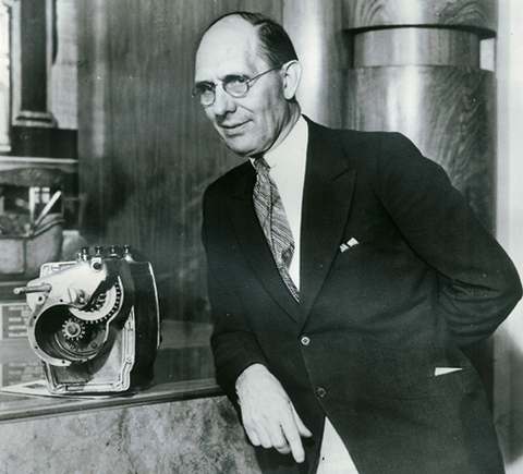
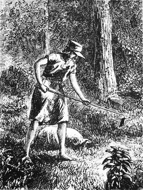
Loudonville sits on the Black Fork of the Mohican River in land inhabited by Delaware people before white settlement; a Delaware village stood just north of the site as late as 1808. Stephen Butler built the first white settler's cabin here in 1810, and in 1814 Thomas Jelloway and James Loudon Priest laid out a twelve-lot village they named for Priest. A post office opened in 1820 and the village incorporated on March 27, 1850. Loudonville became an industrial town in the twentieth century as home to the Flxible Company (1913-1996), maker of buses, hearses and ambulances, and today markets itself as the 'Canoe Capital of Ohio' for its position at the edge of the Mohican River valley and state park country.
Settled 1810, platted 1814, incorporated 1850-03-27, by Thomas Jelloway and James Loudon Priest.
Where the name comes from
Named for James Loudon Priest, who with Thomas Jelloway laid out the original twelve lots of the village in 1814.
Before the town
A Delaware village stood just north of the future village site as of 1808, and the wider Mohican valley held several Delaware settlements. Five miles southwest, on the Clear Fork of the Mohican near the abandoned town of Newville, stood Helltown (from a name meaning 'town of the clear water'), a Delaware and Mingo village; its residents left Helltown and resettled at Greentown, on the Black Fork, as early as 1783 -- Greentown was reportedly named for a British loyalist, Thomas Green, who lived among the Delaware there. Both villages emptied under the pressure and fear that followed the 1782 massacre of Christian Delaware at Gnadenhutten and Colonel William Crawford's 1782 campaign against the Wyandot and Delaware towns on the Sandusky; Greentown itself was burned by Ohio militia in 1812 and its people marched east under guard, several dying along the way. The Mohican River's name itself is of Native origin, an emigrant branch of the Mohican people of Connecticut having given their name to the river. No source found places Greentown or Helltown inside Loudonville's own corporate limits -- both are described as being some miles from the later village -- but they are the nearest documented Native settlements to it and shaped the land Loudonville was built on.
Nations recorded here: Lenape (Delaware), Mingo (Seneca-Cayuga).
- Helltown (village) — Clear Fork of the Mohican, near the former town of Newville, roughly five miles southwest of Loudonville, 18th century, abandoned by 1783 (hmdb.org)
- Greentown (village) — on the Black Fork of the Mohican, northeast of Loudonville, settled c. 1783, burned 1812 (hmdb.org)
Timeline
- — A Delaware village is recorded just north of the future site of Loudonville.
- — Stephen Butler builds the first white settler's cabin, a single log structure on the Black Fork of the Mohican.
- — Thomas Jelloway and James Loudon Priest lay out the village of Loudonville, beginning with twelve lots.
- — A post office named Loudonville opens.
- — Loudonville is formally incorporated on March 27.
- — The Philip J. Black House is built at 303 N. Water St.; later the Blackfork Inn, it is listed on the National Register on May 29, 1980.
- — The City Hall and Opera House (156 N. Water St.) is built; listed on the National Register January 25, 1997.
- — The Flxible Company begins operating in Loudonville, eventually building buses, hearses and ambulances.
- — The Flxible Company closes after 83 years in Loudonville.
Stories
From bus builder to bygone name
The Flxible Company set up in Loudonville in 1913, taking its odd spelling from the flexible joint on its original product, a motorcycle sidecar. The plant grew into the village's dominant employer across most of the twentieth century, turning out intercity coaches, city transit buses, and specialty vehicles including hearses, ambulances and flower cars for the funeral trade. A major fire tore through the plant in 1947 but the company rebuilt and kept building buses for another half-century. When Flxible finally closed in 1996, after 83 years, it took with it the industrial identity Loudonville had built since before the First World War, leaving canoe liveries and Mohican-country tourism as the village's economic anchor instead.
Two villages emptied by fear
In the last years of the American Revolution, Delaware and Mingo families abandoned Helltown on the Clear Fork of the Mohican and moved several miles northeast to found Greentown on the Black Fork, close to the land where Loudonville would later stand. The move followed the 1782 massacre of Christian Delaware converts at the Moravian mission of Gnadenhutten and Colonel William Crawford's campaign that same year against Wyandot and Delaware towns on the Sandusky -- both events that made the Ohio country lethal for Native families regardless of their allegiance. Greentown survived another three decades before Ohio militia burned it in 1812, at the outset of the War of 1812, and marched its residents east under guard; several died on the march. The episode is the clearest documented Native history for the immediate Loudonville area.
Local history sources: en.wikipedia.org · en.wikipedia.org · hmdb.org · archive.org · discovermohican.com
Historic places
3 places in Loudonville on the National Register of Historic Places. Press a pin or a name for its whole record.
-
Black, Philip J., HouseBuilding · Loudonville · listed 1980
- Address
- 303 N. Water St.
- Where
- Loudonville, Ashland County · ZIP 44842
- What it is
- Building
- Listed on the National Register
- 1980
- NRIS reference number
- 80002935
- Coordinates
- 40.63829, -82.23506
National Register file (NPS) ↗ Search Wikipedia ↗ Street map and directions ↗ On the Cracked Buckeye map
-
Bull, T.J. and Sarah, HouseBuilding · Loudonville · listed 2007
- Address
- 109 S. Market St.
- Where
- Loudonville, Ashland County · ZIP 44842
- What it is
- Building
- Listed on the National Register
- 2007
- NRIS reference number
- 07000302
- Coordinates
- 40.63468, -82.23322
National Register file (NPS) ↗ Search Wikipedia ↗ Street map and directions ↗ On the Cracked Buckeye map
-
City Hall and Opera HouseBuilding · Loudonville · listed 1997
- Address
- 156 N. Water St.
- Where
- Loudonville, Ashland County · ZIP 44842
- What it is
- Building
- Listed on the National Register
- 1997
- NRIS reference number
- 96001618
- Coordinates
- 40.63659, -82.23468
National Register file (NPS) ↗ Search Wikipedia ↗ Street map and directions ↗ On the Cracked Buckeye map
Source: National Park Service, National Register of Historic Places point file. The listing year is shown where NPS's certification date agrees with the listing's reference number. Listing recognizes significance; it does not restrict a private owner.
Water
Mostly private wells The water here
- Loudonville Village100% of residentsGroundwater wells (4 wells)
Hospitals, fire stations and more
Inside Loudonville's boundary: 1 fire or EMS station, 3 public schools, 1 library, 1 museum, 1 police station, 2 Toxics Release Inventory facilities, 1 station or terminal and 1 spill case. Press a pin or a name for its whole record and its source.
Fire and EMS stations (1)
-
Loudonville Fire DepartmentLoudonville
- Address
- 200 North Market Street, Loudonville, OH 44842
- Coordinates
- 40.63704, -82.23301
USGS National Map structures (source) ↗ Street map and directions ↗
Source: USGS National Map structures (most Ohio records last updated 2019 to 2022), checked against the Columbus and Cleveland station lists. The department that answers a call is set by jurisdiction and mutual aid, not by distance.
Public schools (3)
-
Budd Elementary School4 of 5 stars · Loudonville
- Address
- 210 E Main St, Loudonville, OH 44842
- School district
- Loudonville-Perrysville Ex Vill School District
- Kind (NCES)
- Regular School
- Students, 2023-24
- 199
- Teachers (full-time equivalent)
- 14.5
- Report card, 2025-26
- 4 of 5 stars
- Performance index
- 82.3%
- Ohio building IRN
- 004192
- NCES school ID
- 390454602224
NCES school record ↗ Ohio School Report Card ↗ Street map and directions ↗
-
Loudonville High School3.5 of 5 stars · Loudonville
- Address
- 421 Campus Ave, Loudonville, OH 44842
- School district
- Loudonville-Perrysville Ex Vill School District
- Kind (NCES)
- Regular School
- Students, 2023-24
- 381
- Teachers (full-time equivalent)
- 33
- Report card, 2025-26
- 3.5 of 5 stars
- Performance index
- 78.6%
- Four-year graduation rate
- 96.4%
- Ohio building IRN
- 021519
- NCES school ID
- 390454602225
NCES school record ↗ Ohio School Report Card ↗ Street map and directions ↗
-
McMullen Elementary School4.5 of 5 stars · Loudonville
- Address
- 224 E Bustle St, Loudonville, OH 44842
- School district
- Loudonville-Perrysville Ex Vill School District
- Kind (NCES)
- Regular School
- Students, 2023-24
- 291
- Teachers (full-time equivalent)
- 17
- Report card, 2025-26
- 4.5 of 5 stars
- Performance index
- 86.3%
- Ohio building IRN
- 023903
- NCES school ID
- 390454602226
NCES school record ↗ Ohio School Report Card ↗ Street map and directions ↗
Source: NCES EDGE public school locations 2024-25 and Common Core of Data 2023-24 (type, students, teachers); Ohio School Report Cards 2025-26 (Department of Education and Workforce), matched by name within the district.
Public libraries (1)
-
Loudonville Public LibraryCentral library · Loudonville
- Address
- 122 E. Main St., Loudonville, OH 44842
- What it is
- Central library
- Library system
- Loudonville Public Library
- Open
- 2,808 hours a year, 52 weeks
- Building
- 25,865 sq ft
- System's visits, FY2024
- 67,808
- System's loans, FY2024
- 167,539
- People the system serves
- 7,801
- Phone
- (419) 994-5531
IMLS Public Libraries Survey (source) ↗ Street map and directions ↗
Source: IMLS Public Libraries Survey FY2024 (outlets and their systems). Any Ohio resident can get a free card at any Ohio public library.
Museums, historical societies, gardens and zoos (1)
-
Mohican Historical SocietyHistorical society · Loudonville
- What it is
- Historical society
- City
- Loudonville
- Coordinates
- 40.63566, -82.23050
Search Wikipedia ↗ IMLS Museum Data Files (source) ↗ Street map and directions ↗
The museum list is IMLS's 2018 file; a museum may have closed or moved since.
Source: IMLS Museum Data Files, 2018.
Police stations (1)
-
Loudonville Police DepartmentLoudonville
- Address
- 156 North Water Street, Loudonville, OH 44842
- Coordinates
- 40.63658, -82.23463
USGS National Map structures (source) ↗ Street map and directions ↗
Source: USGS National Map structures, police stations, corrected and completed by hand (September 2026). The department that answers a call is set by jurisdiction, not by distance.
Facilities reporting toxic releases (2)
-
Mci Service PartsToxics Release Inventory · Loudonville
- Address
- 520 North Spring Street, Loudonville, OH 44842
- County
- Ashland County
- Status
- Reports to the Toxics Release Inventory (active)
- EPA program ID
- 44842THFLX520NO
- EPA registry ID
- 110000815208
EPA facility record ↗ EPA Facility Registry Service (source) ↗ Street map and directions ↗
-
Merillat Industries Inc *Toxics Release Inventory · Loudonville
- Address
- 1 Merillat Ct., Loudonville, OH 44842
- County
- Holmes County
- Status
- Reports to the Toxics Release Inventory (active)
- EPA program ID
- 44842MRLLTONEME
- EPA registry ID
- 110000391665
EPA facility record ↗ EPA Facility Registry Service (source) ↗ Street map and directions ↗
Source: EPA Facility Registry Service, Toxics Release Inventory reporters. Reporting a release is required of large users of listed chemicals; it is not by itself a violation.
Stations and terminals (1)
-
McDonaldsIntercity bus stop · Greyhound Lines
- What it is
- Intercity bus stop
- Operator
- Greyhound Lines
- City
- Loudonville
- Coordinates
- 40.62926, -82.23323
BTS Intermodal Passenger Connectivity Database (source) ↗ Street map and directions ↗
Source: BTS Intermodal Passenger Connectivity Database and National Transit Map (2025). Bus stops are counted on the card and drawn on the full map.
Spills reported since 2021 (1)
-
Oil Transformer Pcb2021-06-29 · Loudonville
- Reported
- 2021-06-29
- What spilled
- Oil Transformer Pcb
- Where
- Loudonville, Ashland County
- Ohio EPA district office
- NWDO
- Ohio EPA case number
- 2106EPA0000955
Ohio EPA spill reports (source) ↗ Street map and directions ↗
Source: Ohio EPA emergency response spill reports, 2021 to September 2026, one point per case where Ohio EPA placed it. A report is what the caller or responder recorded; amounts are often blank or estimated.
Its ZIP codes
Each ZIP code that touches Loudonville, with the share of its residents who live here and the same headline figures as the ZIP page.
| ZIP | Share | Water | Radon | Home value | Schools | Flood |
|---|---|---|---|---|---|---|
| 44842 Loudonville | 49% | Mostly private wells | 11.8 pCi/L average radon | Median year built 1967 | Loudonville-Perrysville Exempted Village · 4 stars overall | 3.4% of residents in the 1% floodplain |
Local government
Who holds office in Loudonville, how its elections and ballot issues came out, and the state auditor's record.
Money issues on the ballot since 2024: 3 of 3 passed.
Ballot issues
| Date | Issue | For | Against | Result |
|---|---|---|---|---|
| 2026-05-05 | Issue: Proposed Tax Levy - Renewal - Vill. of Loudonville - Current Expenses - 1.7 mills / 5 yrs (1.7 mills, renewal) | 254 | 182 | Passed (58.26% for), unofficial |
| 2024-03-19 | Issue 2: 2 Proposed Tax Levy - Renewal - Loudonville Village - Current Expenses - 4.5 Mills / 5 years (4.5 mills, renewal) | 13 | 8 | Passed (61.9% for) |
| 2024-03-19 | Issue 3: 3 Proposed Tax Levy - Renewal - Loudonville Village - Fire Protection - 3.5 Mills / 5 years (3.5 mills, renewal) | 17 | 4 | Passed (80.95% for) |
| 2020-11-03 | Issue: Loudonville Village Ren OE 1.7m (1.7 mills) | 1,030 | 335 | Passed (75.46% for) |
| 2018-11-06 | Issue: Loudonville Village Ren 4.5m CE (4.5 mills) | 683 | 283 | Passed (70.7% for) |
| 2018-11-06 | Issue: Loudonville Village Ren 3.5m FP (3.5 mills) | 780 | 188 | Passed (80.58% for) |
Elections for office
| Date | Office | Candidates and votes |
|---|---|---|
| 2025-11-04 | Member of Council (unofficial count) | Bill Huffman 346, 25.07%; Catherine J. Lance 348, 25.22%; Shawn Wade 345, 25.0%; Thomas A. Young 341, 24.71% |
| 2023-11-07 | Member of Council (unofficial count) | Brandon T. Biddinger 713, 100.0% |
| 2023-11-07 | Member of Council | Brandon T. Biddinger 34, 100.0% |
| 2023-11-07 | Mayor (unofficial count) | Jason Van Sickle 715, 100.0% |
| 2021-11-02 | Member of Council | Catherine J. Lance 395, 33.14%; Hollie McCauley 347, 29.11%; Thomas A. Young 347, 29.11%; Write-In: William A. Huffman 103, 8.64% |
| 2021-11-02 | Mayor | Jason A. Van Sickle 462, 100.0% |
| 2021-11-02 | Mayor (unofficial count) | Jason A. Van Sickle 18, 100.0% |
| 2019-11-05 | Mayor | Steve Stricklen 407, 63.3%; Thomas A. Young 236, 36.7% |
| 2019-11-05 | Council | Brandon T. Biddinger 320, 27.54%; Michael Robinson 121, 10.41%; Bill Welsh 339, 29.17%; Matthew F. Young 382, 32.87% |
| 2017-11-07 | Council | Traci L. Cooper 440, 23.29%; Ted L. Fraser 235, 12.44%; Thomas A. Gallagher 369, 19.53%; Jason A. Van Sickle 431, 22.82%; Thomas A. Young 414, 21.92% |
Winners in bold. Results from the county board of elections' official canvass unless marked.
Auditor of State record
- No fiscal caution, watch or emergency on the Auditor of State's lists.
- Financial Audit, 2024 to 2025, released 2026-07-21
- Financial Audit, 2022 to 2023, released 2024-07-16
The county
Ashland County: 9 ZIP codes, 22 cities, villages and townships, 50,803 people.
Nearby places
Rain and snow
How much has actually fallen on Loudonville, day by day, from 1893 to now. Daily totals, not averages.
- rain, last 30 days
- 1.58 in
- 2026-09-30 to 2026-10-29
- rain so far in 2026
- 39.5 in
- 3.4 in above normal for the date
- snow so far in 2026
- 22.5 in
- a normal year brings 30.8 in
- a normal year
- 42.2 in
- average of 30 years, 1991-2020
| Month | Rain (in) | Snow (in) | Days counted |
|---|---|---|---|
| October 2026 | 1.58 | — | 29 |
| September 2026 | 4.75 | — | 30 |
| August 2026 | 5.72 | — | 31 |
| July 2026 | 3.60 | — | 31 |
| June 2026 | 2.97 | — | 30 |
| May 2026 | 6.18 | — | 31 |
| April 2026 | 6.77 | — | 30 |
| March 2026 | 4.55 | 1.3 | 31 |
| February 2026 | 1.64 | 4.1 | 28 |
| January 2026 | 1.78 | 17.0 | 31 |
| December 2025 | 2.58 | 12.6 | 31 |
| November 2025 | 1.88 | 0.7 | 30 |
| Wettest year | 2011 — 59.4 in |
|---|---|
| Driest year | 1963 — 25.3 in |
| Snowiest year | 1910 — 67.1 in |
| Wettest day on record | 14 September 1979 — 4.91 in |
| Heaviest snowfall in a day | 8 March 2008 — 11.34 in |
| Deepest snow on the ground | 31 January 1978 — 20.81 in |
Estimated, not measured. No rain gauge has ever stood inside Loudonville, so every figure here is worked out from the gauges around it - the nearest ones weighted most. Treat them as close estimates rather than readings.
48,824 days of records, 1893-01-01 to 2026-10-29. Source: NOAA NCEI GHCN-Daily, 3,240 gauges in and around Ohio. A day is "gauged" when a gauge standing inside the boundary reported it, and the value is the mean of those gauges. Otherwise it is interpolated by inverse distance from every gauge reporting within 50 miles. Nothing is carried forward, back-filled or smoothed. Against NOAA nClimDiv county monthly precipitation over 136,848 complete county-months (checked 2026-10-31): correlation 0.9515, median absolute difference 0.217 in a month. Built 2026-10-31 from the Cracked Buckeye precipitation archive. Snow is the softer number — snowfall is measured by hand with a ruler, no agency publishes a gridded county snowfall series, and blowing snow defeats every observer.
Environmental permits and filings
What Ohio EPA has on file for Loudonville: permits, inspections, violations, cleanups and the state loans behind sewer and water work. Every line links to the agency's own document.
- facilities and sites on file
- 13
- those placed on the map inside Loudonville
| Program | Facilities and sites |
|---|---|
| Air pollution | 4 |
| Hazardous waste | 3 |
| Public drinking water | 2 |
| Wastewater and stormwater discharge | 2 |
| Contaminated-site cleanup | 1 |
| Voluntary cleanup | 1 |
| Date | Facility or site | What |
|---|---|---|
| LOUDONVILLE VILLAGE PWS | Public drinking water plan | |
| LOUDONVILLE VILLAGE PWS | Public drinking water notice of violation | |
| LOUDONVILLE VILLAGE PWS | Public drinking water inspection | |
| LOUDONVILLE VILLAGE PWS | Public drinking water compliance letter | |
| LOUDONVILLE VILLAGE PWS | Public drinking water report | |
| GOLF BALL REFURBISHERS | Air pollution report | |
| LOUDONVILLE FARMERS EQUITY CO | Air pollution report | |
| LOUDONVILLE VILLAGE PWS | Public drinking water inspection | |
| LOUDONVILLE VILLAGE PWS | Public drinking water compliance letter | |
| LOUDONVILLE VILLAGE PWS | Public drinking water violation resolved | |
| LOUDONVILLE VILLAGE PWS | Public drinking water plan | |
| LOUDONVILLE VILLAGE PWS | Public drinking water inspection | |
| LOUDONVILLE VILLAGE PWS | Public drinking water notice of violation | |
| LOUDONVILLE VILLAGE PWS | Public drinking water inspection | |
| LOUDONVILLE VILLAGE PWS | Public drinking water warning letter | |
| LOUDONVILLE VILLAGE PWS | Public drinking water compliance letter | |
| LOUDONVILLE VILLAGE PWS | Public drinking water notice of violation | |
| LOUDONVILLE VILLAGE PWS | Public drinking water report | |
| LOUDONVILLE VILLAGE PWS | Public drinking water warning letter | |
| LOUDONVILLE WTP | Wastewater and stormwater discharge permit | |
| LOUDONVILLE WTP | Wastewater and stormwater discharge permit | |
| LOUDONVILLE VILLAGE PWS | Public drinking water compliance letter | |
| LOUDONVILLE WTP | Wastewater and stormwater discharge inspection | |
| LOUDONVILLE VILLAGE PWS | Public drinking water compliance letter | |
| LOUDONVILLE VILLAGE PWS | Public drinking water inspection |
Source: Ohio EPA eDocument portal (edocpub.epa.ohio.gov), indexed 2026-10-14. Facilities are placed on the map from Ohio EPA's own map layers, EPA's Facility Registry, coordinates written in the filings, or a geocoded street address. A permit filed under a private person's name (most are household septic systems) is counted but never named, placed or linked; licenses for individual workers and open-burning notices are left out entirely.
Quick answers
What county is Loudonville, Ohio in?
Loudonville is a village in Ashland County, Ohio, with 2,766 residents.
When was Loudonville, Ohio founded?
Loudonville was settled 1810; laid out 1814; incorporated 1850-03-27. Founders on record: Thomas Jelloway and James Loudon Priest. Source
How did Loudonville, Ohio get its name?
Named for James Loudon Priest, who with Thomas Jelloway laid out the original twelve lots of the village in 1814. Source
What ZIP code is Loudonville, Ohio?
Most of Loudonville is in ZIP code 44842.
Where does Loudonville, Ohio get its water?
The main water source for Loudonville (Loudonville Village): Mostly private wells.
Cite this page
Cite this page as:
Cracked Buckeye, "Loudonville, Ashland County", https://crackedbuckeye.com/place/loudonville/, built 2026-10-31, accessed [date].
How to cite · Report a correction · Built 2026-10-31
