Local events in Leesburg
Nothing is posted for Leesburg itself yet; here is what is on within 20 miles. All local events in Leesburg
Know a calendar we should watch? Send the link
Checked October 20; the events page is refreshed daily.
How Leesburg began
Leesburg was laid out in 1802, by a local newspaper history's account (the county histories date the plat to 1814), by Nathaniel Pope, John Walters, and John Howard on the fertile farmland of eastern Highland County, and named for Leesburg, Virginia, the region many of its settlers had left. Flouring and woolen mills built on nearby streams gave the young village its first commerce, and by the mid-1800s a small business district of general stores, blacksmith shops, and workshops had grown up around them. The arrival of the railroad and a depot in the 19th century tied Leesburg to wider markets, and agriculture has remained the base of its economy ever since. Today it is a village of about 1,300 people, still known locally as "the Friendly Village," that hosts an annual Leesburg Luminaria (started 1991) and summer festival.
Settled early 1800s, platted March 1814 (James Johnson), with New Leesburg added June 1821 (S. McClure, A. Chalfont, C. Lupton) per Thompson 1878; a local newspaper history says 1802, by Nathaniel Pope, John Walters, and John Howard.
Where the name comes from
A local newspaper history says the village was named for Leesburg, Virginia, reflecting where its settlers came from. Scott (1890) separately records that Lees Creek, on which the town stands, was named for General Charles Lee, whose military land warrants were located on its waters.
Before the town
No source found ties a named Native village, trail, mound, or documented encounter specifically to the ground that became Leesburg. The 1890 county history says only in general terms that treaties of 1784 and 1785 extinguished Native claims to the southern and eastern parts of the state; the land that became Leesburg passed to the United States at the 1795 Treaty of Greenville. The same history places named Indian towns on the waters of the Scioto to the east and references frontier movement through what became Marshall and Rainsboro elsewhere in the county, but it gives no site in or immediately around Leesburg itself. Elsewhere in Highland County, the Adena/Hopewell mound record includes Fort Hill, roughly 10 miles southeast of Hillsboro. Nathaniel Pope's party reached the site in 1799 or 1800 (Klise and Scott differ) along the old Indian trail from Oldtown on the North Fork of Paint Creek to old Chillicothe, and found Native neighbors camped in large numbers along Rattlesnake Creek, who visited the settlers almost daily and sometimes hunted with them; the 1902 county history tells of William Pope racing a Shawnee afoot after a bear.
Timeline
- — Nathaniel Pope, who had been told he could pick land from General Massie's holdings, settles on Lees Creek where Leesburg now stands; Scott dates the move to spring 1800.
- — Pope sows the first wheat known in Highland County on a few acres where the Leesburg brick school stands today.
- — A local newspaper history says Leesburg was laid out in 1802 by Nathaniel Pope, John Walters and John Howard and named for Leesburg, Virginia; Klise (1902) names these three as the first settlers but dates the town's plat to 1814 (James Johnson), with a 'New Leesburg' addition in 1821.
- — William Lupton buys Pope's farm and builds a saw-mill on Lees Creek; the Quakers' log meeting house, built in 1803-04, is later replaced by a brick church in Leesburg.
- — James Johnson's plat of Leesburg is dated March 1814.
- — A post office named Leesburgh opens; it takes the spelling Leesburg in 1893.
- — Leesburg's population is recorded at 131.
- — S. McClure, A. Chalfont and C. Lupton plat New Leesburg.
- — David Swain starts a carding mill at Leesburg; it passes to William W. Hardy, who builds a woolen mill there in 1837.
- — Fairfield Local Schools, which still serves Leesburg, is established.
- — John C. Batton establishes a steam flouring mill at Leesburg.
- — A Universalist church is built at Leesburg, with James and Samuel McClure among its founders.
- — Senator Buel Beeson's store at Leesburg is burned, a crime the county history ascribes to opposition to the early anti-saloon movement.
- — The railroad is opened from Greenfield through Leesburg to Blanchester, connecting to the Little Miami line for Cincinnati.
- — The Leesburg Bank is established, in the nation's centennial year.
- — The census counts 783 people in Leesburg.
- — The Farmers and Merchants Bank of Leesburg is established.
- — Leesburg's population reaches 828 in the 1910 census, a figure it holds near 840 through 1950 before rising to 1,314 in 2010.
- — The Leesburg Lions Club starts the Leesburg Luminaria, a candlelit winter event that continues today.
- — Leesburg reaches its census high of 1,314 residents.
Stories
Mills on the millrace
Leesburg's earliest economy ran on water power: flouring mills and woolen mills built along the streams near the village turned the corn, wheat, and oats of the surrounding farms and the wool of local flocks into flour and cloth that could be sold or traded. These mills became the first commercial centers of the community, drawing farm families into the village to do business and, over time, anchoring a small downtown of general stores, a blacksmith shop, and workshops by the mid-1800s. The pattern was typical of Highland County's early villages, which grew up wherever a millrace could be dug rather than along any single road or rail line.
The depot years
When the railroad reached Leesburg, the village built a depot that changed its relationship to the outside world: grain, livestock, and manufactured goods could now move to distant markets, and travelers could come the other way. The Srofe Building in the village later housed a changing run of businesses, including a bakery and a telephone exchange, evidence of a small town continuing to adapt through the early 20th century even as its population growth leveled off. The depot building itself survives and has been photographed for the local historical record.
The first wheat and the Shawnee bear hunt
Nathaniel Pope left Virginia in fall 1796 with a low-wheeled mountain cart, spent a winter at the falls of the Kanawha and settled for a year or two on the Ohio before learning he could not buy the land. In 1799 (Scott says 1800) he came up Paint Creek to Lees Creek, cleared ground on the bottom and sowed what both county histories call the first wheat in what is now Highland County. John Walters took the place across the creek and James Howard built a cabin on the hill where Leesburg stands. Their neighbors were Shawnee camped along Rattlesnake Creek, who came almost daily and were glad of a meal. One fall day the Popes were hunting a bear on Hardin's Creek when a Shawnee joined the chase on foot and William Pope took up his challenge to a race. Pope outran him to the creek, rested against a tree and shot the bear, which fell badly wounded and seized one of Pope's favorite dogs. Pope motioned the Shawnee to kill it with his tomahawk, but the man only said 'White man,' so Pope went in with tomahawk and knife and finished it. They divided the meat, the Shawnee left well pleased, and the two became the best of friends and hunted together often.
Photographs
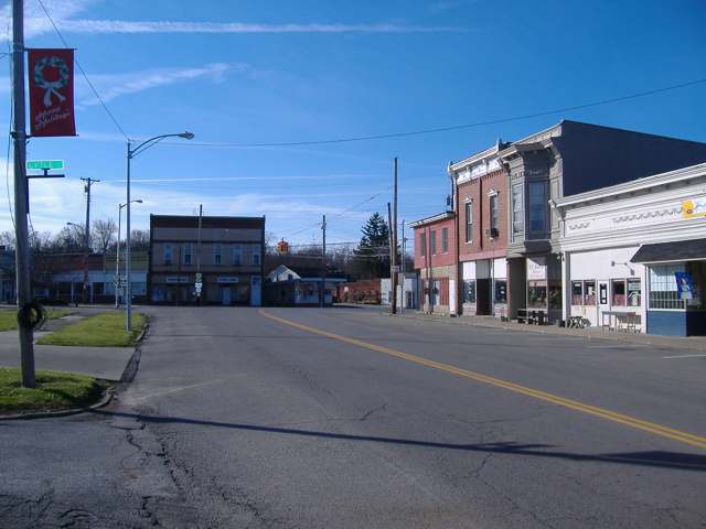
Photo: Aesopposea (Wikimedia Commons), CC BY-SA 3.0 · Wikimedia Commons
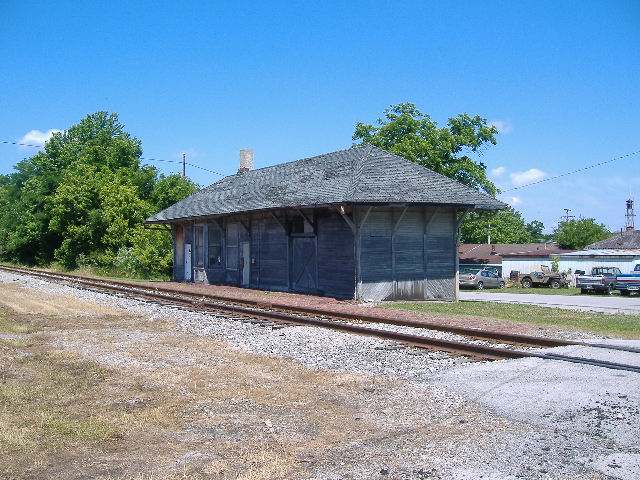
Photo: Aesopposea (Wikimedia Commons), CC BY-SA 3.0 · Wikimedia Commons
Local history sources: en.wikipedia.org · en.wikipedia.org · leesburgtimes.org · leesburgtimes.org · archive.org · archive.org · commons.wikimedia.org · archive.org · commons.wikimedia.org · commons.wikimedia.org · postalhistory.com
Water
Mostly private wells The water here
- Leesburg Village100% of residentsGroundwater wells (4 wells)
Hospitals, fire stations and more
Inside Leesburg's boundary: 1 fire or EMS station, 3 public schools, 1 library, 1 police station, 1 Toxics Release Inventory facility and 3 spill cases. Press a pin or a name for its whole record and its source.
Fire and EMS stations (1)
-
Highland County North Joint Fire Department and AmbulanceLeesburg
- Address
- 200 South Street, Leesburg, OH 45135
- Coordinates
- 39.34604, -83.55066
USGS National Map structures (source) ↗ Street map and directions ↗
Source: USGS National Map structures (most Ohio records last updated 2019 to 2022), checked against the Columbus and Cleveland station lists. The department that answers a call is set by jurisdiction and mutual aid, not by distance.
Public schools (3)
-
Fairfield Local Elementary School4 of 5 stars · Leesburg
- Address
- 11611 State Route 771, Leesburg, OH 45135
- School district
- Fairfield Local School District
- Kind (NCES)
- Regular School
- Students, 2023-24
- 432
- Teachers (full-time equivalent)
- 24
- Report card, 2025-26
- 4 of 5 stars
- Performance index
- 86%
- Ohio building IRN
- 011031
- NCES school ID
- 390476202930
NCES school record ↗ Ohio School Report Card ↗ Street map and directions ↗
-
Fairfield Local High School4 of 5 stars · Leesburg
- Address
- 11611 State Route 771, Leesburg, OH 45135
- School district
- Fairfield Local School District
- Kind (NCES)
- Regular School
- Students, 2023-24
- 248
- Teachers (full-time equivalent)
- 13
- Report card, 2025-26
- 4 of 5 stars
- Performance index
- 79.1%
- Four-year graduation rate
- 92.5%
- Ohio building IRN
- 011056
- NCES school ID
- 390476202929
NCES school record ↗ Ohio School Report Card ↗ Street map and directions ↗
-
Fairfield Local Middle School4.5 of 5 stars · Leesburg
- Address
- 11611 State Route 771, Leesburg, OH 45135
- School district
- Fairfield Local School District
- Kind (NCES)
- Regular School
- Students, 2023-24
- 218
- Teachers (full-time equivalent)
- 9
- Report card, 2025-26
- 4.5 of 5 stars
- Performance index
- 79.8%
- Ohio building IRN
- 142190
- NCES school ID
- 390476204620
NCES school record ↗ Ohio School Report Card ↗ Street map and directions ↗
Source: NCES EDGE public school locations 2024-25 and Common Core of Data 2023-24 (type, students, teachers); Ohio School Report Cards 2025-26 (Department of Education and Workforce), matched by name within the district.
Public libraries (1)
-
Leesburg BranchBranch · Leesburg
- Address
- 240 E. Main, Leesburg, OH 45135
- What it is
- Branch
- Library system
- Highland County District Library
- Open
- 2,288 hours a year, 52 weeks
- Building
- 4,500 sq ft
- System's visits, FY2024
- 115,752
- System's loans, FY2024
- 258,208
- People the system serves
- 42,139
- Phone
- (937) 780-7295
IMLS Public Libraries Survey (source) ↗ Street map and directions ↗
Source: IMLS Public Libraries Survey FY2024 (outlets and their systems). Any Ohio resident can get a free card at any Ohio public library.
Police stations (1)
-
Leesburg Police DepartmentLeesburg
- Address
- 57 South Fairfield Street, Leesburg, OH 45135
- Coordinates
- 39.34404, -83.55465
USGS National Map structures (source) ↗ Street map and directions ↗
Source: USGS National Map structures, police stations, corrected and completed by hand (September 2026). The department that answers a call is set by jurisdiction, not by distance.
Facilities reporting toxic releases (1)
-
Candle-Lite IncToxics Release Inventory · Leesburg
- Address
- 250 Eastern Ave., Leesburg, OH 45135
- County
- Highland County
- Status
- Reports to the Toxics Release Inventory (active)
- EPA program ID
- 45135CNDLL250EA
- EPA registry ID
- 110000392842
EPA facility record ↗ EPA Facility Registry Service (source) ↗ Street map and directions ↗
Source: EPA Facility Registry Service, Toxics Release Inventory reporters. Reporting a release is required of large users of listed chemicals; it is not by itself a violation.
Spills reported since 2021 (3)
-
Oil Hydraulic Fluid(S)2025-09-29 · Leesburg
- Reported
- 2025-09-29
- What spilled
- Oil Hydraulic Fluid(S)
- Largest amount reported
- 5 gallons
- Where
- Leesburg, Highland County
- Ohio EPA district office
- SWDO
- Ohio EPA case number
- 2509EPA0001616
Ohio EPA spill reports (source) ↗ Street map and directions ↗
-
Material Undetermined / Other Reached water2021-02-05 · Leesburg
- Reported
- 2021-02-05
- What spilled
- Material Undetermined / Other
- Largest amount reported
- 1,000 gallons
- Reached a waterway
- 36 - Rattlesnake Creek
- Where
- Leesburg, Highland County
- Ohio EPA district office
- SWDO
- Ohio EPA case number
- 2102EPA0000170
Ohio EPA spill reports (source) ↗ Street map and directions ↗
-
Other / All Other / Trade Name / Mixture / Solution Etc2026-08-05 · Leesburg
- Reported
- 2026-08-05
- What spilled
- Other / All Other / Trade Name / Mixture / Solution Etc
- Largest amount reported
- 2,000 gallons
- Where
- Leesburg, Highland County
- Ohio EPA district office
- SWDO
- Ohio EPA case number
- 2608EPA0001427
Ohio EPA spill reports (source) ↗ Street map and directions ↗
Source: Ohio EPA emergency response spill reports, 2021 to September 2026, one point per case where Ohio EPA placed it. A report is what the caller or responder recorded; amounts are often blank or estimated.
Its ZIP codes
Each ZIP code that touches Leesburg, with the share of its residents who live here and the same headline figures as the ZIP page.
| ZIP | Share | Water | Radon | Home value | Schools | Flood |
|---|---|---|---|---|---|---|
| 45135 Fairfield Township and Leesburg | 27% | Mostly private wells | 4.8 pCi/L average radon | Appraisal records without year built | Fairfield Local · 4.5 stars overall | 1.3% of residents in the 1% floodplain |
Local government
Who holds office in Leesburg, how its elections and ballot issues came out, and the state auditor's record.
Elections for office
| Date | Office | Candidates and votes |
|---|---|---|
| 2023-11-07 | Member of Council | Kenny Worley 235, 100.0% |
| 2023-11-07 | Mayor | Shawn C. Priest 125, 43.86%; Rita J. Smith-Daulton 160, 56.14% |
| 2021-11-02 | Member of Council (unofficial count) | Bob Barrett Jr. 75, 24.27%; Kim Pavey 64, 20.71%; Richard A. Smith 59, 19.09%; John Michael 46, 14.89%; Richard Tolle 45, 14.56%; Blythe Pelham 20, 6.47% |
| 2019-11-05 | Member of Council | Rit J. Smith-Daulton 105, 44.12%; Kenneth W. Worley 105, 44.12%; Blythe Pelham 28, 11.76% |
| 2019-11-05 | Mayor | Shawn C. Priest 126, 100.0% |
Winners in bold. Results from the county board of elections' official canvass unless marked.
Auditor of State record
- No fiscal caution, watch or emergency on the Auditor of State's lists.
- Financial Audit, 2024, released 2025-10-14
- Financial Audit, 2022 to 2023, released 2024-10-17
The county
Highland County: 7 ZIP codes, 26 cities, villages and townships, 42,302 people.
Nearby places
Rain and snow
How much has actually fallen on Leesburg, day by day, from 1893 to now. Daily totals, not averages.
- rain, last 30 days
- 0.77 in
- 2026-09-30 to 2026-10-29
- rain so far in 2026
- 41.2 in
- 3.6 in above normal for the date
- snow so far in 2026
- 18.6 in
- a normal year brings 21.2 in
- a normal year
- 44.4 in
- average of 30 years, 1991-2020
| Month | Rain (in) | Snow (in) | Days counted |
|---|---|---|---|
| October 2026 | 0.77 | — | 29 |
| September 2026 | 7.71 | — | 30 |
| August 2026 | 5.71 | — | 31 |
| July 2026 | 3.34 | — | 31 |
| June 2026 | 4.74 | — | 30 |
| May 2026 | 4.63 | — | 31 |
| April 2026 | 4.34 | — | 30 |
| March 2026 | 7.40 | 1.2 | 31 |
| February 2026 | 1.17 | 6.0 | 28 |
| January 2026 | 1.44 | 11.4 | 31 |
| December 2025 | 2.62 | 11.5 | 31 |
| November 2025 | 3.62 | 3.6 | 30 |
| Wettest year | 2011 — 60.0 in |
|---|---|
| Driest year | 1901 — 24.4 in |
| Snowiest year | 1910 — 53.1 in |
| Wettest day on record | 23 July 1965 — 4.41 in |
| Heaviest snowfall in a day | 6 January 1910 — 11.38 in |
| Deepest snow on the ground | 21 January 1978 — 22.59 in |
Estimated, not measured. No rain gauge has ever stood inside Leesburg, so every figure here is worked out from the gauges around it - the nearest ones weighted most. Treat them as close estimates rather than readings.
48,874 days of records, 1893-01-01 to 2026-10-29. Source: NOAA NCEI GHCN-Daily, 3,240 gauges in and around Ohio. A day is "gauged" when a gauge standing inside the boundary reported it, and the value is the mean of those gauges. Otherwise it is interpolated by inverse distance from every gauge reporting within 50 miles. Nothing is carried forward, back-filled or smoothed. Against NOAA nClimDiv county monthly precipitation over 136,848 complete county-months (checked 2026-10-31): correlation 0.9515, median absolute difference 0.217 in a month. Built 2026-10-31 from the Cracked Buckeye precipitation archive. Snow is the softer number — snowfall is measured by hand with a ruler, no agency publishes a gridded county snowfall series, and blowing snow defeats every observer.
Environmental permits and filings
What Ohio EPA has on file for Leesburg: permits, inspections, violations, cleanups and the state loans behind sewer and water work. Every line links to the agency's own document.
- facilities and sites on file
- 2
- those placed on the map inside Leesburg
| Program | Facilities and sites |
|---|---|
| Public drinking water | 1 |
| State water loans | 1 |
| Date | Facility or site | What |
|---|---|---|
| LEESBURG VILLAGE PWS | Public drinking water compliance letter | |
| LEESBURG VILLAGE PWS | Public drinking water notice of violation | |
| LEESBURG VILLAGE PWS | Public drinking water report | |
| LEESBURG VILLAGE PWS | Public drinking water plan | |
| LEESBURG VILLAGE PWS | Public drinking water inspection | |
| LEESBURG VILLAGE PWS | Public drinking water inspection | |
| LEESBURG VILLAGE PWS | Public drinking water inspection | |
| LEESBURG VILLAGE PWS | Public drinking water compliance letter | |
| LEESBURG VILLAGE PWS | Public drinking water report | |
| LEESBURG VILLAGE PWS | Public drinking water compliance letter | |
| LEESBURG VILLAGE PWS | Public drinking water notice of violation | |
| LEESBURG VILLAGE PWS | Public drinking water compliance letter | |
| LEESBURG VILLAGE PWS | Public drinking water inspection | |
| LEESBURG VILLAGE PWS | Public drinking water report | |
| LEESBURG VILLAGE PWS | Public drinking water compliance letter | |
| LEESBURG VILLAGE PWS | Public drinking water withdrawn | |
| LEESBURG VILLAGE PWS | Public drinking water notice of violation | |
| LEESBURG VILLAGE PWS | Public drinking water compliance letter | |
| LEESBURG VILLAGE PWS | Public drinking water permit | |
| LEESBURG VILLAGE PWS | Public drinking water compliance letter | |
| LEESBURG VILLAGE PWS | Public drinking water report | |
| LEESBURG VILLAGE PWS | Public drinking water compliance letter | |
| LEESBURG VILLAGE PWS | Public drinking water report | |
| LEESBURG VILLAGE PWS | Public drinking water notice of violation | |
| LEESBURG VILLAGE PWS | Public drinking water inspection |
Source: Ohio EPA eDocument portal (edocpub.epa.ohio.gov), indexed 2026-10-14. Facilities are placed on the map from Ohio EPA's own map layers, EPA's Facility Registry, coordinates written in the filings, or a geocoded street address. A permit filed under a private person's name (most are household septic systems) is counted but never named, placed or linked; licenses for individual workers and open-burning notices are left out entirely.
Quick answers
What county is Leesburg, Ohio in?
Leesburg is a village in Highland County, Ohio, with 1,273 residents.
When was Leesburg, Ohio founded?
Leesburg was settled early 1800s; laid out March 1814 (James Johnson), with New Leesburg added June 1821 (S. McClure, A. Chalfont, C. Lupton) per Thompson 1878; a local newspaper history says 1802. Founders on record: Nathaniel Pope, John Walters, and John Howard. Source
How did Leesburg, Ohio get its name?
A local newspaper history says the village was named for Leesburg, Virginia, reflecting where its settlers came from. Source
What ZIP code is Leesburg, Ohio?
Most of Leesburg is in ZIP code 45135.
Where does Leesburg, Ohio get its water?
The main water source for Leesburg (Leesburg Village): Mostly private wells.
Cite this page
Cite this page as:
Cracked Buckeye, "Leesburg, Highland County", https://crackedbuckeye.com/place/leesburg/, built 2026-10-31, accessed [date].
How to cite · Report a correction · Built 2026-10-31
