Harrison Township, Montgomery County
Township · Montgomery County · 21,876 residents
Local events in Harrison Township, Montgomery County
13 events in the next 90 days from 1 public calendar. All local events in Harrison Township, Montgomery County
Checked October 20; the events page is refreshed daily.
How Harrison Township, Montgomery County began
Harrison Township was organized in 1841, about a month after President William Henry Harrison's death in office, and named in his honor. Settlers had farmed the Congress Lands there since the early 1800s, and small crossroads communities grew up around country churches and later around interurban rail stops: Ebenezer (later Northridge), founded around a Methodist congregation formed after the War of 1812; Shiloh, which took its name from a church established in the 1850s; and Fort McKinley, platted in the early twentieth century when the Dayton-Greenville traction line planned a stop nearby. Much of the township's original farmland has since been annexed into the city of Dayton, and Interstate 75's arrival in the 1950s turned what remained into a manufacturing and commercial corridor; the township today is an unincorporated ring of communities, including Northridge, Fort McKinley and most of Shiloh, wrapped around Dayton's north and west sides.
Settled early 1800s, incorporated 1841, by Organized as a Montgomery County township in 1841, named for President William Henry Harrison shortly after his death.
Where the name comes from
The township was established in 1841, about one month after President William Henry Harrison died in office, and was named to honor him.
Before the town
No mound, village, earthwork or named Native American site specific to present-day Harrison Township was found in the sources checked. The township's land lay within the Great Miami and Stillwater valley country used by the Miami and, under agreement with the Miami, the Shawnee, who held villages and hunting grounds through the region into the late 1700s; it was opened to settlement by the 1795 Treaty of Greenville, which several sources on the wider Dayton area describe as running near the Great Miami valley shortly before the first settlers arrived in the county. No source consulted names a specific village, camp, trail or burial site within the township's boundaries.
Nations recorded here: Miami, Shawnee.
Timeline
- — The Treaty of Greenville opened the Great Miami and Stillwater valley country, including the future Harrison Township, to settlement.
- — Settlers took up farms in the area under the Congress Lands system following the American Revolution, ahead of the township's formal organization.
- — A Methodist congregation organized after the War of 1812 and built its first log-and-clapboard church at the northwest corner of the future Dixie Drive/Frederick Pike intersection; the crossroads took the congregation's name, Ebenezer.
- — Harrison Township was organized and named for President William Henry Harrison, who had died in office about a month earlier.
- — A church called Shiloh was established in the township; the surrounding community took its name.
- — The Ebenezer congregation built a second church, of masonry, across the road from its original log structure; the building still stands.
- — The Fort McKinley area was established, by the township's own account (Wikipedia's Fort McKinley article gives 1914), when the Dayton-Greenville traction (interurban rail) line planned a stop near Salem Avenue and Free Pike; George F. Mumma suggested naming it for President McKinley, with 'Fort' added for distinction.
- — The Ebenezer congregation built a third church in random-rubble stone as suburban growth followed the Dayton & Troy interurban line, and renamed itself Victory Methodist Church, marking both a spiritual theme and the end of World War I; the surrounding area came to be called Northridge.
- — Construction of Interstate 75 through the township spurred its growth into a manufacturing and commercial corridor.
- — A catastrophic EF4 tornado struck the Shiloh area of the township as part of the Memorial Day 2019 Dayton-area tornado outbreak.
Stories
One church, three buildings, two names
The community now called Northridge grew up around a single Methodist congregation that outgrew its building twice. Formed in the years after the War of 1812, the congregation first met in a log-and-clapboard church at what is now the corner of Dixie Drive and Frederick Pike, and the place took its name, Ebenezer, from the Old Testament phrase meaning 'hitherto hath the Lord helped us.' A more permanent church of masonry went up across the road in 1860 and is still standing. By the 1910s the interurban line to Troy was pulling new residents up that corridor, and in 1919 the congregation built a third church, this one of random rubble stone in a plain gothic style, and renamed itself Victory Methodist Church, a name that read two ways that year: spiritual victory, and the just-ended World War. The old Ebenezer name stuck to the neighborhood and, in the early 1920s, to the local school district, even after the church itself had moved on.
A president's name, twice
Harrison Township carries a president's name for a simple reason of timing: it was organized in 1841, within weeks of President William Henry Harrison's death after only a month in office, and the new township took his name. Six decades later a different community inside the township, forming around a stop on the Dayton-Greenville interurban line, was named for another president, William McKinley, at the suggestion of local landowner George F. Mumma; 'Fort' was added for distinction, and the area was platted in 1905. Neither Fort McKinley nor Harrison Township has a fort or a presidential residence to show for the names, just the coincidence of being platted and organized while a sitting or recently deceased president was in the news.
Photographs
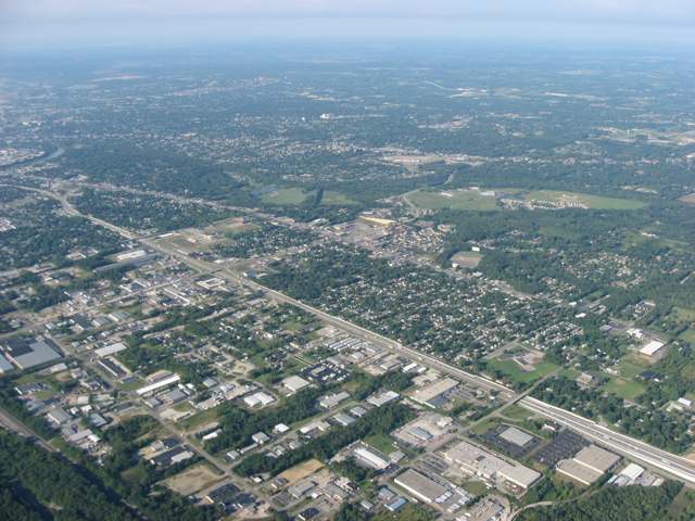
Photo: Nyttend (own work), public domain · Wikimedia Commons
Local history sources: en.wikipedia.org · harrisontownship.org · daytonology.blogspot.com · en.wikipedia.org · en.wikipedia.org · en.wikipedia.org · en.wikipedia.org · thislocallife.com · commons.wikimedia.org
Water
Miami Well Field wells by the Great Miami River at Wagner Ford/Needmore Rd and Rip Rap Road Island, north Dayton The water here
- Montgomery County Water Services 267% of residentsGreat Miami Buried Valley Aquifer wells (recharged by Great Miami & Mad Rivers)
- Dayton Public Water System31% of residentsGreat Miami Buried Valley Aquifer wells (recharged by Great Miami & Mad Rivers)
- Montgomery County Water Services 11% of residentsGreat Miami Buried Valley Aquifer wells (recharged by Great Miami & Mad Rivers)
- Englewood City1% of residentsStillwater Buried Valley Aquifer (wells)
Hospitals, fire stations and more
Inside Harrison Township, Montgomery County's boundary: 3 dialysis centers, 4 nursing homes, 2 fire and EMS stations, 14 public schools, 1 private school, 2 poor-rated bridges, 1 public charging site, 1 Superfund site, 10 Toxics Release Inventory facilities and 30 spill cases. Press a pin or a name for its whole record and its source.
Dialysis centers (3)
-
Davita Dayton North DialysisDialysis · Dayton
- Address
- 455 Turner Road, Dayton, OH 45415
- Dialysis stations
- 44
- Medicare star rating
- 3 of 5 stars
- Services
- in-center hemodialysis
- Shift starting after 5 pm
- Yes
- Ownership
- for profit
- Chain
- DaVita
- Medicare certified since
- 1998-06-17
- Phone
- (937) 278-7861
- Medicare ID
- 362595
Medicare Care Compare ↗ CMS dialysis facility list (source) ↗ Street map and directions ↗
-
Davita Five Rivers DialysisDialysis · Dayton
- Address
- 4750 N Main Street, Dayton, OH 45405
- Dialysis stations
- 17
- Medicare star rating
- 3 of 5 stars
- Services
- in-center hemodialysis
- Ownership
- for profit
- Chain
- DaVita
- Medicare certified since
- 2013-12-13
- Phone
- (937) 278-5139
- Medicare ID
- 362803
Medicare Care Compare ↗ CMS dialysis facility list (source) ↗ Street map and directions ↗
-
Davita Home Dialysis DaytonDialysis · Dayton
- Address
- 455 Turner Road, Suite B, Dayton, OH 45415
- Dialysis stations
- 6
- Medicare star rating
- 2 of 5 stars
- Services
- peritoneal dialysis
- Ownership
- for profit
- Chain
- DaVita
- Medicare certified since
- 1995-02-02
- Phone
- (937) 278-8261
- Medicare ID
- 362542
Medicare Care Compare ↗ CMS dialysis facility list (source) ↗ Street map and directions ↗
Source: CMS dialysis facility list, September 2026, geocoded with the Census Bureau batch geocoder (an address it could not place sits at its ZIP center).
Nursing homes (4)
-
Aventura at Carriage Inn3 of 5 stars · Dayton
- Address
- 5040 Philadelphia Drive, Dayton, OH 45415
- Certified beds
- 85
- Residents on an average day
- 71
- Medicare overall rating
- 3 of 5 stars
- Health inspections
- 2 of 5 stars
- Staffing
- 2 of 5 stars
- Quality measures
- 5 of 5 stars
- Penalties since 2023
- none
- Ownership
- For profit - Corporation
- Chain
- AVENTURA HEALTH GROUP
- Takes
- Medicare and Medicaid
- Phone
- (937) 278-0404
- Medicare ID
- 365876
Medicare Care Compare ↗ CMS nursing home data (source) ↗ Street map and directions ↗
-
Riverside Nursing and Rehabilitation Center2 of 5 stars · Dayton
- Address
- 1390 King Tree Drive, Dayton, OH 45405
- Certified beds
- 180
- Residents on an average day
- 164
- Medicare overall rating
- 2 of 5 stars
- Health inspections
- 1 of 5 stars
- Staffing
- 2 of 5 stars
- Quality measures
- 5 of 5 stars
- Penalties since 2023
- 2 fines totalling $85,284 (latest 2025-09-02)
- Ownership
- For profit - Corporation
- Chain
- COMMUNICARE HEALTH
- Takes
- Medicare and Medicaid
- Phone
- (937) 278-0723
- Medicare ID
- 365877
Medicare Care Compare ↗ CMS nursing home data (source) ↗ Street map and directions ↗
-
Siena Woods Care Center4 of 5 stars · Dayton
- Address
- 6125 N Main Street, Dayton, OH 45415
- Certified beds
- 99
- Residents on an average day
- 87
- Medicare overall rating
- 4 of 5 stars
- Health inspections
- 3 of 5 stars
- Staffing
- 3 of 5 stars
- Quality measures
- 5 of 5 stars
- Penalties since 2023
- none
- Ownership
- For profit - Corporation
- Chain
- EXCEPTIONAL LIVING CENTERS
- Continuing care retirement community
- Yes
- Takes
- Medicare and Medicaid
- Phone
- (937) 278-8211
- Medicare ID
- 365819
Medicare Care Compare ↗ CMS nursing home data (source) ↗ Street map and directions ↗
-
Stonespring of Vandalia5 of 5 stars · Dayton
- Address
- 4000 Singing Hills Bvld, Dayton, OH 45414
- Certified beds
- 144
- Residents on an average day
- 137
- Medicare overall rating
- 5 of 5 stars
- Health inspections
- 4 of 5 stars
- Staffing
- 2 of 5 stars
- Quality measures
- 5 of 5 stars
- Penalties since 2023
- none
- Ownership
- For profit - Limited Liability company
- Chain
- CARESPRING
- Takes
- Medicare and Medicaid
- Phone
- (937) 415-8000
- Medicare ID
- 366388
- Map point
- the ZIP's center (the address did not geocode)
Medicare Care Compare ↗ CMS nursing home data (source) ↗ Street map and directions ↗
Source: CMS Care Compare nursing home provider and penalties files; Medicare star ratings run 1 to 5.
Fire and EMS stations (2)
-
Harrison Township Fire Department Station 94Dayton
- Address
- 2400 Turner Road, Dayton, OH 45415
- Coordinates
- 39.81318, -84.24068
USGS National Map structures (source) ↗ Street map and directions ↗
-
Harrison Township Fire Department Station 95Dayton
- Address
- 2245 Needmore Road, Dayton, OH 45414
- Coordinates
- 39.82007, -84.19195
USGS National Map structures (source) ↗ Street map and directions ↗
Source: USGS National Map structures (most Ohio records last updated 2019 to 2022), checked against the Columbus and Cleveland station lists. The department that answers a call is set by jurisdiction and mutual aid, not by distance.
Public schools (14)
-
3EADayton
- Address
- 4407 Payne Ave, Dayton, OH 45414
- Kind (NCES)
- Regular School
- Students, 2023-24
- 2
- NCES school ID
- 390487306154
-
Charity Adams Earley Girls Academy3 of 5 stars · Dayton
- Address
- 440 Shoup Mill Rd, Dayton, OH 45415
- School district
- Dayton City School District
- Kind (NCES)
- Regular School
- Students, 2023-24
- 320
- Teachers (full-time equivalent)
- 17
- Report card, 2025-26
- 3 of 5 stars
- Performance index
- 51.7%
- Ohio building IRN
- 000884
- NCES school ID
- 390438405101
NCES school record ↗ Ohio School Report Card ↗ Street map and directions ↗
-
Dayton Athletic Vocational AcademyDayton
- Address
- 100 E Woodbury Dr, Dayton, OH 45415
- Kind (NCES)
- Regular School
- Students, 2023-24
- 92
- Teachers (full-time equivalent)
- 5
- NCES school ID
- 390158705880
-
Engage High SchoolDayton
- Address
- 6401 N Main St, Dayton, OH 45415
- Kind (NCES)
- Regular School
- Students, 2023-24
- 62
- Teachers (full-time equivalent)
- 4.5
- NCES school ID
- 391004510831
-
Horizon Science Academy Dayton High SchoolDayton
- Address
- 250 Shoup Mill Rd, Dayton, OH 45415
- Kind (NCES)
- Regular School
- Students, 2023-24
- 259
- Teachers (full-time equivalent)
- 23
- NCES school ID
- 390136605556
-
Horizon Science Academy-DaytonDayton
- Address
- 4751 Sue Ann Blvd, Dayton, OH 45415
- Kind (NCES)
- Regular School
- Students, 2023-24
- 193
- Teachers (full-time equivalent)
- 12
- NCES school ID
- 390044405003
-
Meadowdale High School3 of 5 stars · Dayton
- Address
- 3873 Whitestone Ct, Dayton, OH 45416
- School district
- Dayton City School District
- Kind (NCES)
- Regular School
- Students, 2023-24
- 519
- Teachers (full-time equivalent)
- 40
- Report card, 2025-26
- 3 of 5 stars
- Performance index
- 51.1%
- Four-year graduation rate
- 73.7%
- Ohio building IRN
- 023986
- NCES school ID
- 390438400813
NCES school record ↗ Ohio School Report Card ↗ Street map and directions ↗
-
North Dayton School of DiscoveryDayton
- Address
- 3901 Turner Rd, Dayton, OH 45415
- Kind (NCES)
- Regular School
- Students, 2023-24
- 596
- Teachers (full-time equivalent)
- 39.17
- NCES school ID
- 390021604740
-
Northridge Elementary School2.5 of 5 stars · Dayton
- Address
- 2011 Timber Ln, Dayton, OH 45414
- School district
- Northridge Local School District
- Kind (NCES)
- Regular School
- Students, 2023-24
- 781
- Teachers (full-time equivalent)
- 43
- Report card, 2025-26
- 2.5 of 5 stars
- Performance index
- 59.2%
- Ohio building IRN
- 025577
- NCES school ID
- 390487303379
NCES school record ↗ Ohio School Report Card ↗ Street map and directions ↗
-
Northridge High School3 of 5 stars · Dayton
- Address
- 2011 Timber Ln, Dayton, OH 45414
- School district
- Northridge Local School District
- Kind (NCES)
- Regular School
- Students, 2023-24
- 493
- Teachers (full-time equivalent)
- 25
- Report card, 2025-26
- 3 of 5 stars
- Performance index
- 53.3%
- Four-year graduation rate
- 97.4%
- Ohio building IRN
- 027763
- NCES school ID
- 390487303380
NCES school record ↗ Ohio School Report Card ↗ Street map and directions ↗
-
NORTHRIDGE MIDDLE SCHOOL2 of 5 stars · Dayton
- Address
- 2011 Timber Ln, Dayton, OH 45414
- School district
- Northridge Local School District
- Kind (NCES)
- Regular School
- Students, 2023-24
- 382
- Teachers (full-time equivalent)
- 21
- Report card, 2025-26
- 2 of 5 stars
- Performance index
- 45.9%
- Ohio building IRN
- 013995
- NCES school ID
- 390487303378
NCES school record ↗ Ohio School Report Card ↗ Street map and directions ↗
-
Summit Academy Community School - DaytonDayton
- Address
- 251 Erdiel Dr, Dayton, OH 45415
- Kind (NCES)
- Regular School
- Students, 2023-24
- 73
- Teachers (full-time equivalent)
- 7
- NCES school ID
- 390049305203
-
Summit Academy Transition High School DaytonDayton
- Address
- 251 Erdiel Dr, Dayton, OH 45415
- Kind (NCES)
- Regular School
- Students, 2023-24
- 53
- Teachers (full-time equivalent)
- 8
- NCES school ID
- 390034804885
-
Valerie Elementary School2 of 5 stars · Dayton
- Address
- 3871 Yellowstone Ave, Dayton, OH 45416
- School district
- Dayton City School District
- Kind (NCES)
- Regular School
- Students, 2023-24
- 515
- Teachers (full-time equivalent)
- 36
- Report card, 2025-26
- 2 of 5 stars
- Performance index
- 42.3%
- Ohio building IRN
- 023978
- NCES school ID
- 390438400812
NCES school record ↗ Ohio School Report Card ↗ Street map and directions ↗
Source: NCES EDGE public school locations 2024-25 and Common Core of Data 2023-24 (type, students, teachers); Ohio School Report Cards 2025-26 (Department of Education and Workforce), matched by name within the district.
Private schools (1)
-
Gloria Dei Montessori SchoolPrivate, nonsectarian, special program · Dayton
- Address
- 615 Shiloh Dr, Dayton, OH 45415
- Kind
- nonsectarian, special program
- Students, 2023-24
- 48
- Teachers (full-time equivalent)
- 4.4
- Students per teacher
- 10.9091
- Phone
- (937) 274-7195
- NCES private school ID
- 01062827
Source: NCES Private School Survey 2023-24.
Bridges rated poor (2)
-
E Park Drive Wdriv over StreamPoor · built 1900
- Condition
- Poor: a deck, superstructure, substructure or culvert rated 4 or below on the 0 to 9 scale
- What it is
- Bridge
- Built
- 1900
- Length
- 7 ft
- Owner
- Township
- Vehicles a day
- 5
- Coordinates
- 39.82220, -84.22721
National Bridge Inventory (source) ↗ Street map and directions ↗
-
Shoup Mill Rd. over Storm SewerPoor · built 1968
- Condition
- Poor: a deck, superstructure, substructure or culvert rated 4 or below on the 0 to 9 scale
- What it is
- Culvert
- Built
- 1968
- Length
- 7 ft
- Owner
- County
- Vehicles a day
- 26,981
- Coordinates
- 39.81288, -84.22634
National Bridge Inventory (source) ↗ Street map and directions ↗
Source: FHWA National Bridge Inventory 2025. "Poor" means one major part rated 4 or below on the 0 to 9 scale; it calls for repair, not closing, unless the state posts or closes the bridge.
Public EV charging (1)
-
Maggies Place2 Level 2 · Dayton
- Address
- 6515 N. Dixie Dr, Dayton, OH 45414
- Ports
- 2 Level 2
- Plugs
- J1772
- Network
- Blink Network
- Hours
- 24 hours daily
- Phone
- 888-998-2546
Station Locator (NREL) ↗ Alternative Fuels Data Center (source) ↗ Street map and directions ↗
Source: NREL Alternative Fuels Data Center station list (May 2026), public and open stations, the posts at one address counted as one site.
Superfund sites (1)
-
Plate Rite Plating SiteSuperfund program · Dayton
- Address
- 5311 Webster St, Dayton, OH 45414
- County
- Montgomery County
- Status
- Superfund program site, not on the National Priorities List
- EPA program ID
- OHN000510495
- EPA registry ID
- 110004698943
EPA facility record ↗ EPA Facility Registry Service (source) ↗ Street map and directions ↗
Source: EPA Facility Registry Service, Superfund (SEMS) and National Priorities List sites. Many program sites were assessed and needed no cleanup.
Facilities reporting toxic releases (10)
-
American Carco CorpToxics Release Inventory · Dayton
- Address
- 2800 Ontario Ave, Dayton, OH 45414
- County
- Montgomery County
- Status
- Reports to the Toxics Release Inventory (closed)
- EPA program ID
- 45414MRCNC2800O
- EPA registry ID
- 110000617002
EPA facility record ↗ EPA Facility Registry Service (source) ↗ Street map and directions ↗
-
Creative FoamToxics Release Inventory · Dayton
- Address
- 3337 N Dixie Dr, Dayton, OH 45414
- County
- Montgomery County County
- Status
- Reports to the Toxics Release Inventory (***unchanged***)
- EPA program ID
- 4541WCRTVF3337N
- EPA registry ID
- 110071947796
EPA facility record ↗ EPA Facility Registry Service (source) ↗ Street map and directions ↗
-
Heidelberg Web SystemsToxics Release Inventory · Dayton
- Address
- 4900 Webster Street, Dayton, OH 45414
- County
- Montgomery County
- Status
- Reports to the Toxics Release Inventory (active)
- EPA program ID
- 45414MGRPH4900W
- EPA registry ID
- 110009489847
EPA facility record ↗ EPA Facility Registry Service (source) ↗ Street map and directions ↗
-
Lord Corporation (0857731802)Toxics Release Inventory · Dayton
- Address
- 4644 Wadsworth Rd., Dayton, OH 45414
- County
- Montgomery County
- Status
- Reports to the Toxics Release Inventory (active)
- EPA program ID
- 45414LRDCR4644W
- EPA registry ID
- 110000394733
EPA facility record ↗ EPA Facility Registry Service (source) ↗ Street map and directions ↗
-
NovToxics Release Inventory · Dayton
- Address
- 5870 Poe Ave., Dayton, OH 45414
- County
- Montgomery County
- Status
- Reports to the Toxics Release Inventory (active)
- EPA program ID
- 45414CHMNR5870P
- EPA registry ID
- 110000394715
EPA facility record ↗ EPA Facility Registry Service (source) ↗ Street map and directions ↗
-
Rubber Seal (0857733184)Toxics Release Inventory · Dayton
- Address
- 5751 North Webster Street, Dayton, OH 45414
- County
- Montgomery County
- Status
- Reports to the Toxics Release Inventory (active)
- EPA program ID
- 45414RBBRS5751N
- EPA registry ID
- 110002113917
EPA facility record ↗ EPA Facility Registry Service (source) ↗ Street map and directions ↗
-
Siemens Energy & Automation Service CoToxics Release Inventory · Dayton
- Address
- 5131 Webster Street, Dayton, OH 45414
- County
- Montgomery County
- Status
- Reports to the Toxics Release Inventory (active)
- EPA program ID
- 45414SMNSN5131W
- EPA registry ID
- 110002455290
EPA facility record ↗ EPA Facility Registry Service (source) ↗ Street map and directions ↗
-
Wall Colmonoy Corp. (0857730260)Toxics Release Inventory · Dayton
- Address
- 5251 Webster St., Dayton, OH 45414
- County
- Montgomery County
- Status
- Reports to the Toxics Release Inventory (active)
- EPA program ID
- 45414WLLCL5251W
- EPA registry ID
- 110002113935
EPA facility record ↗ EPA Facility Registry Service (source) ↗ Street map and directions ↗
-
Yoder Industries IncToxics Release Inventory · Dayton
- Address
- 2520 Needmore Rd, Dayton, OH 45414
- County
- Montgomery County
- Status
- Reports to the Toxics Release Inventory (active)
- EPA program ID
- 45414YDRND2520N
- EPA registry ID
- 110000394779
EPA facility record ↗ EPA Facility Registry Service (source) ↗ Street map and directions ↗
-
Yoder Industries IncToxics Release Inventory · Dayton
- Address
- 3009 Production Ct., Dayton, OH 45414
- County
- Montgomery County
- Status
- Reports to the Toxics Release Inventory (active)
- EPA program ID
- 45414YDRND3009P
- EPA registry ID
- 110000500217
EPA facility record ↗ EPA Facility Registry Service (source) ↗ Street map and directions ↗
Source: EPA Facility Registry Service, Toxics Release Inventory reporters. Reporting a release is required of large users of listed chemicals; it is not by itself a violation.
Spills reported since 2021 (30)
-
Fat(S) / Oil / Grease / Tallow Food Types (Fog)2025-09-13 · Harrison Twp
- Reported
- 2025-09-13
- What spilled
- Fat(S) / Oil / Grease / Tallow Food Types (Fog)
- Where
- Harrison Twp, Montgomery County
- Ohio EPA district office
- SWDO
- Ohio EPA case number
- 2509EPA0001545
Ohio EPA spill reports (source) ↗ Street map and directions ↗
-
Fuel Diesel / Diesel Fuel (Vehicle On Or Off Road)2025-07-21 · Harrison Twp
- Reported
- 2025-07-21
- What spilled
- Fuel Diesel / Diesel Fuel (Vehicle On Or Off Road)
- Largest amount reported
- 100 gallons
- Where
- Harrison Twp, Montgomery County
- Ohio EPA district office
- SWDO
- Ohio EPA case number
- 2507EPA0001213
Ohio EPA spill reports (source) ↗ Street map and directions ↗
-
Oil Motor / Lube Oil / Vehicle2025-07-17 · Harrison Twp
- Reported
- 2025-07-17
- What spilled
- Oil Motor / Lube Oil / Vehicle
- Largest amount reported
- 110 gallons
- Where
- Harrison Twp, Montgomery County
- Ohio EPA district office
- SWDO
- Ohio EPA case number
- 2507EPA0001190
Ohio EPA spill reports (source) ↗ Street map and directions ↗
-
Waste Water2025-02-27 · Harrison Twp
- Reported
- 2025-02-27
- What spilled
- Waste Water
- Where
- Harrison Twp, Montgomery County
- Ohio EPA district office
- SWDO
- Ohio EPA case number
- 2502EPA0000267
Ohio EPA spill reports (source) ↗ Street map and directions ↗
-
Material Green Reached water2024-10-29 · Harrison Twp
- Reported
- 2024-10-29
- What spilled
- Material Green
- Reached a waterway
- 99 - Unnamed
- Where
- Harrison Twp, Montgomery County
- Ohio EPA district office
- SWDO
- Ohio EPA case number
- 2410EPA0001809
Ohio EPA spill reports (source) ↗ Street map and directions ↗
-
Material Unknown Reached water2024-10-21 · Harrison Twp
- Reported
- 2024-10-21
- What spilled
- Material Unknown
- Reached a waterway
- 57 - Great Miami River
- Where
- Harrison Twp, Montgomery County
- Ohio EPA district office
- SWDO
- Ohio EPA case number
- 2410EPA0001775
Ohio EPA spill reports (source) ↗ Street map and directions ↗
-
Oil Motor / Lube Oil / Vehicle2024-10-08 · Harrison Twp
- Reported
- 2024-10-08
- What spilled
- Oil Motor / Lube Oil / Vehicle; Fuel Ethanol / E85 / Ethyl / Gasohol (Denatured); Fuel Diesel / Diesel Fuel (Vehicle On Or Off Road)
- Where
- Harrison Twp, Montgomery County
- Ohio EPA district office
- SWDO
- Ohio EPA case number
- 2410EPA0001722
Ohio EPA spill reports (source) ↗ Street map and directions ↗
-
Fuel Diesel / Diesel Fuel (Vehicle On Or Off Road)2024-09-26 · Harrison Twp
- Reported
- 2024-09-26
- What spilled
- Fuel Diesel / Diesel Fuel (Vehicle On Or Off Road)
- Where
- Harrison Twp, Montgomery County
- Ohio EPA district office
- SWDO
- Ohio EPA case number
- 2409EPA0001649
Ohio EPA spill reports (source) ↗ Street map and directions ↗
-
Fuel Gasoline ( 25% Ethanol Not E85)2024-08-13 · Harrison Twp
- Reported
- 2024-08-13
- What spilled
- Fuel Gasoline ( 25% Ethanol Not E85)
- Where
- Harrison Twp, Montgomery County
- Ohio EPA district office
- SWDO
- Ohio EPA case number
- 2408EPA0001402
Ohio EPA spill reports (source) ↗ Street map and directions ↗
-
Asphalt / Bitumen2024-07-16 · Harrison Twp
- Reported
- 2024-07-16
- What spilled
- Asphalt / Bitumen
- Where
- Harrison Twp, Montgomery County
- Ohio EPA district office
- SWDO
- Ohio EPA case number
- 2407EPA0001197
Ohio EPA spill reports (source) ↗ Street map and directions ↗
-
Oil Crude2024-06-11 · Harrison Twp
- Reported
- 2024-06-11
- What spilled
- Oil Crude
- Largest amount reported
- 15 gallons
- Where
- Harrison Twp, Montgomery County
- Ohio EPA district office
- SWDO
- Ohio EPA case number
- 2406EPA0000981
Ohio EPA spill reports (source) ↗ Street map and directions ↗
-
Waste Water Reached water2024-05-24 · Harrison Twp
- Reported
- 2024-05-24
- What spilled
- Waste Water
- Reached a waterway
- 57 - Great Miami River
- Where
- Harrison Twp, Montgomery County
- Ohio EPA district office
- SWDO
- Ohio EPA case number
- 2405EPA0000873
Ohio EPA spill reports (source) ↗ Street map and directions ↗
-
Waste Water Reached water2024-04-19 · Harrison Twp
- Reported
- 2024-04-19
- What spilled
- Waste Water
- Reached a waterway
- 99 - Unnamed
- Where
- Harrison Twp, Montgomery County
- Ohio EPA district office
- SWDO
- Ohio EPA case number
- 2404EPA0000658
Ohio EPA spill reports (source) ↗ Street map and directions ↗
-
Fuel Diesel / Diesel Fuel (Vehicle On Or Off Road)2024-03-06 · Harrison Twp
- Reported
- 2024-03-06
- What spilled
- Fuel Diesel / Diesel Fuel (Vehicle On Or Off Road)
- Largest amount reported
- 200 gallons
- Where
- Harrison Twp, Montgomery County
- Ohio EPA district office
- SWDO
- Ohio EPA case number
- 2403EPA0000352
Ohio EPA spill reports (source) ↗ Street map and directions ↗
-
Fuel Diesel / Diesel Fuel (Vehicle On Or Off Road)2023-06-19 · Harrison Twp
- Reported
- 2023-06-19
- What spilled
- Fuel Diesel / Diesel Fuel (Vehicle On Or Off Road)
- Largest amount reported
- 70 gallons
- Where
- Harrison Twp, Montgomery County
- Ohio EPA district office
- SWDO
- Ohio EPA case number
- 2306EPA0001009
Ohio EPA spill reports (source) ↗ Street map and directions ↗
-
Oil Petroleum Not Otherwise Specified (Nos)2023-06-06 · Harrison Twp
- Reported
- 2023-06-06
- What spilled
- Oil Petroleum Not Otherwise Specified (Nos)
- Where
- Harrison Twp, Montgomery County
- Ohio EPA district office
- SWDO
- Ohio EPA case number
- 2306EPA0000933
Ohio EPA spill reports (source) ↗ Street map and directions ↗
-
Battery Acid (Dilute Sulfuric)2023-04-27 · Harrison Twp
- Reported
- 2023-04-27
- What spilled
- Battery Acid (Dilute Sulfuric)
- Where
- Harrison Twp, Montgomery County
- Ohio EPA district office
- SWDO
- Ohio EPA case number
- 2304EPA0000678
Ohio EPA spill reports (source) ↗ Street map and directions ↗
-
Other / All Other / Trade Name / Mixture / Solution Etc2023-04-20 · Harrison Twp
- Reported
- 2023-04-20
- What spilled
- Other / All Other / Trade Name / Mixture / Solution Etc
- Largest amount reported
- 100 gallons
- Where
- Harrison Twp, Montgomery County
- Ohio EPA district office
- SWDO
- Ohio EPA case number
- 2304EPA0000628
Ohio EPA spill reports (source) ↗ Street map and directions ↗
-
Corn Syrup2022-06-30 · Harrison Twp
- Reported
- 2022-06-30
- What spilled
- Corn Syrup
- Where
- Harrison Twp, Montgomery County
- Ohio EPA district office
- SWDO
- Ohio EPA case number
- 2206EPA0000985
Ohio EPA spill reports (source) ↗ Street map and directions ↗
-
Fuel Diesel / Diesel Fuel (Vehicle On Or Off Road) Reached water2022-05-19 · Harrison Twp
- Reported
- 2022-05-19
- What spilled
- Fuel Diesel / Diesel Fuel (Vehicle On Or Off Road)
- Largest amount reported
- 100 gallons
- Reached a waterway
- 99 - Unnamed
- Where
- Harrison Twp, Montgomery County
- Ohio EPA district office
- SWDO
- Ohio EPA case number
- 2205EPA0000737
Ohio EPA spill reports (source) ↗ Street map and directions ↗
-
Chemical(S) Unk2022-05-12 · Harrison Twp
- Reported
- 2022-05-12
- What spilled
- Chemical(S) Unk
- Where
- Harrison Twp, Montgomery County
- Ohio EPA district office
- SWDO
- Ohio EPA case number
- 2205EPA0000683
Ohio EPA spill reports (source) ↗ Street map and directions ↗
-
Fuel Diesel / Diesel Fuel (Vehicle On Or Off Road)2022-02-03 · Harrison Twp
- Reported
- 2022-02-03
- What spilled
- Fuel Diesel / Diesel Fuel (Vehicle On Or Off Road)
- Largest amount reported
- 50 gallons
- Where
- Harrison Twp, Montgomery County
- Ohio EPA district office
- SWDO
- Ohio EPA case number
- 2202EPA0000121
Ohio EPA spill reports (source) ↗ Street map and directions ↗
-
Fertilizer(S) Nos (Not Specified)2021-08-23 · Harrison Twp
- Reported
- 2021-08-23
- What spilled
- Fertilizer(S) Nos (Not Specified)
- Largest amount reported
- 150 gallons
- Where
- Harrison Twp, Montgomery County
- Ohio EPA district office
- SWDO
- Ohio EPA case number
- 2108EPA0001317
Ohio EPA spill reports (source) ↗ Street map and directions ↗
-
Oil Transformer Pcb2021-06-17 · Harrison Twp
- Reported
- 2021-06-17
- What spilled
- Oil Transformer Pcb
- Largest amount reported
- 2 gallons
- Where
- Harrison Twp, Montgomery County
- Ohio EPA district office
- SWDO
- Ohio EPA case number
- 2106EPA0000879
Ohio EPA spill reports (source) ↗ Street map and directions ↗
-
Oil Petroleum Not Otherwise Specified (Nos)2021-06-08 · Harrison Twp
- Reported
- 2021-06-08
- What spilled
- Oil Petroleum Not Otherwise Specified (Nos)
- Where
- Harrison Twp, Montgomery County
- Ohio EPA district office
- SWDO
- Ohio EPA case number
- 2106EPA0000813
Ohio EPA spill reports (source) ↗ Street map and directions ↗
-
Oil Transformer Non Pcb2021-05-10 · Harrison Twp
- Reported
- 2021-05-10
- What spilled
- Oil Transformer Non Pcb
- Largest amount reported
- 50 gallons
- Where
- Harrison Twp, Montgomery County
- Ohio EPA district office
- SWDO
- Ohio EPA case number
- 2105EPA0000646
Ohio EPA spill reports (source) ↗ Street map and directions ↗
-
Oil Hydraulic Fluid(S)2021-03-20 · Harrison Twp
- Reported
- 2021-03-20
- What spilled
- Oil Hydraulic Fluid(S)
- Where
- Harrison Twp, Montgomery County
- Ohio EPA district office
- SWDO
- Ohio EPA case number
- 2103EPA0000370
Ohio EPA spill reports (source) ↗ Street map and directions ↗
-
Oil Hydraulic Fluid(S)2021-01-12 · Harrison Twp
- Reported
- 2021-01-12
- What spilled
- Oil Hydraulic Fluid(S)
- Largest amount reported
- 35 gallons
- Where
- Harrison Twp, Montgomery County
- Ohio EPA district office
- SWDO
- Ohio EPA case number
- 2101EPA0000039
Ohio EPA spill reports (source) ↗ Street map and directions ↗
-
Water (H20) Reached water2026-07-04 · Harrison Twp
- Reported
- 2026-07-04
- What spilled
- Water (H20)
- Reached a waterway
- 57 - Great Miami River
- Where
- Harrison Twp, Montgomery County
- Ohio EPA district office
- SWDO
- Ohio EPA case number
- 2607EPA0001202
Ohio EPA spill reports (source) ↗ Street map and directions ↗
-
Water (H20)2026-02-25 · Harrison Twp
- Reported
- 2026-02-25
- What spilled
- Water (H20)
- Where
- Harrison Twp, Montgomery County
- Ohio EPA district office
- SWDO
- Ohio EPA case number
- 2602EPA0000236
Ohio EPA spill reports (source) ↗ Street map and directions ↗
Source: Ohio EPA emergency response spill reports, 2021 to September 2026, one point per case where Ohio EPA placed it. A report is what the caller or responder recorded; amounts are often blank or estimated.
Its ZIP codes
Each ZIP code that touches Harrison Township, Montgomery County, with the share of its residents who live here and the same headline figures as the ZIP page.
Local government
Who holds office in Harrison Township, Montgomery County, how its elections and ballot issues came out, and the state auditor's record.
Money issues on the ballot since 2026: 1 of 1 passed; of those asking for new or higher taxes, 1 of 1.
Ballot issues
| Date | Issue | For | Against | Result |
|---|---|---|---|---|
| 2026-05-05 | Issue: Harrison Township - Additional - Police - 3.5 Mills - Con't period of time (3.5 mills, additional) | 1,310 | 1,066 | Passed (55.13% for) |
Elections for office
| Date | Office | Candidates and votes |
|---|---|---|
| 2025-11-04 | Trustee (unofficial count) | Clinton Ball 898, 22.38%; Georgeann Godsey 1,307, 32.57%; Roland Winburn 1,808, 45.05% |
Winners in bold. Results from the county board of elections' official canvass unless marked.
Auditor of State record
- No fiscal caution, watch or emergency on the Auditor of State's lists.
- Financial Audit, 2025, released 2026-06-23
- Financial Audit, 2024, released 2025-07-22
The county
Montgomery County: 33 ZIP codes, 27 cities, villages and townships, 531,614 people.
Nearby places
Quick answers
What county is Harrison Township, Ohio in?
Harrison Township, Montgomery County is a township in Montgomery County, Ohio, with 21,876 residents.
When was Harrison Township, Ohio founded?
Harrison Township, Montgomery County was settled early 1800s; incorporated 1841. Founders on record: Organized as a Montgomery County township in 1841, named for President William Henry Harrison shortly after his death. Source
How did Harrison Township, Ohio get its name?
The township was established in 1841, about one month after President William Henry Harrison died in office, and was named to honor him. Source
What ZIP code is Harrison Township, Ohio?
Harrison Township, Montgomery County is served by ZIP codes 45415, 45414, 45405, 45416 and 45406; 45415 holds the largest share of its residents.
Where does Harrison Township, Ohio get its water?
The main water source for Harrison Township, Montgomery County (Montgomery County Water Services 2): Miami Well Field wells by the Great Miami River at Wagner Ford/Needmore Rd and Rip Rap Road Island, north Dayton.
Cite this page
Cite this page as:
Cracked Buckeye, "Harrison Township, Montgomery County", https://crackedbuckeye.com/place/harrison-township-montgomery-county/, built 2026-10-31, accessed [date].
How to cite · Report a correction · Built 2026-10-31
