Garrettsville
Village · Portage County · 2,449 residents · 1.75% municipal income tax
Local events in Garrettsville
22 events in the next 90 days from 3 public calendars. All local events in Garrettsville
Checked October 20; the events page is refreshed daily.
Notable people from Garrettsville
Ohioans tied to this place, each with a sourced profile. All notable Ohioans
History from Garrettsville
People and inventions tied to this place, each with its sources. All people · All inventions
How Garrettsville began
Garrettsville takes its name from Colonel John Garrett III, who bought 300 acres in what was then Nelson Township in 1803 for $1,313 and arrived with his family in July 1804 to build a grist mill; Garrett died in January 1806, the same month his mill was to open. The Cleveland-Pittsburgh Road, built near the mill in 1806, brought commerce, and by the early 1900s Garrettsville had become, by local telling, the world's largest center for processing maple syrup. The village incorporated September 1, 1864. On November 6, 1935, Alvin Karpis and the Barker-Karpis Gang robbed a train there, stealing $30,000 and fleeing by private plane — remembered as among the last great train robberies in American history. Today, ZIP 44231, Garrettsville has 2,449 residents (2020).
Settled July 1804 (Colonel John Garrett III and family), incorporated September 1, 1864, by Colonel John Garrett III.
Where the name comes from
Named for Colonel John Garrett III, who purchased 300 acres of what was then Nelson Township land in 1803 for $1,313 (roughly $4.40 an acre) and settled there in 1804 to build a grist mill.
Before the town
No Native American village, camp or mound site specific to Garrettsville is documented in the sources consulted; Garrettsville grew out of the southwestern corner of Nelson Township, where the county history 'Portage Heritage' records Cayuga people camping near the Nelson Ledges and an 1803 killing of a man called Big Cayuga by settler Delaun Mills, though neither is placed within the village site itself. For the county's broader Native history.
Timeline
- — Colonel John Garrett III purchases 300 acres in what is then Nelson Township for $1,313.
- — Garrett arrives in July with his family, including two enslaved girls aged 6 and 10, and begins building a grist mill.
- — Garrett dies in January, the same month his grist mill is set to open; the Cleveland-Pittsburgh Road is built near the mill, boosting commerce.
- — The Garrettsville post office is established.
- — Garrettsville incorporates as a village on September 1.
- — A published bird's-eye-view map records the village's population at 1,100.
- — Garrettsville becomes, by local account, the largest center in the world for processing maple syrup, led by Arthur Crane's cannery operations.
- — On November 6, Alvin Karpis and the Barker-Karpis Gang rob a train in Garrettsville, stealing about $30,000 and escaping by private airplane to Hot Springs, Arkansas.
- — A downtown fire on March 22 destroys about one city block and 13 businesses; 34 surrounding fire departments assist.
Stories
A mill founder who never saw it open
John Garrett III bought his 300 acres on the strength of a mill site — water power reliable enough to justify building a grist mill that would serve the whole surrounding countryside. He brought his family out from the East in July 1804, including, the record states plainly, two enslaved girls aged six and ten, and spent a year and a half building toward January 1806, when the mill was finally due to open. Garrett died that same month, never seeing the business run. The Cleveland-Pittsburgh Road, built past the mill site not long after, ensured the settlement around it grew anyway, eventually taking Garrett's own name even though its founder never lived to see it become a real village.
The last great train robbery
By November 1935, the era of the romanticized outlaw train robber was already fading into memory, replaced by bank jobs and car chases. Alvin Karpis and the Barker-Karpis Gang gave it one more chapter anyway, robbing a train passing through Garrettsville and getting away with roughly $30,000 — then, in a flourish that belonged more to the automobile-and-airplane age than the Old West, escaping by private plane to Hot Springs, Arkansas rather than on horseback. Karpis was eventually captured and sent to Alcatraz, where he served longer than any other inmate in the prison's history, a small Ohio village's brush with organized crime folded into one of the more storied criminal careers of the era.
Photographs
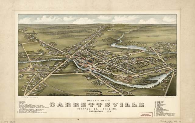
Photo: Library of Congress Geography and Map Division, public domain · Wikimedia Commons
Local history sources: en.wikipedia.org · archive.org · commons.wikimedia.org · commons.wikimedia.org
Historic places
1 place in Garrettsville on the National Register of Historic Places. Press a pin or a name for its whole record.
-
Mott Drug StoreBuilding · Garrattsville · listed 1996
- Address
- 8107 Main St.
- Where
- Garrattsville, Portage County · ZIP 44231
- What it is
- Building
- Listed on the National Register
- 1996
- NRIS reference number
- 96000221
- Coordinates
- 41.28517, -81.09786
National Register file (NPS) ↗ Search Wikipedia ↗ Street map and directions ↗ On the Cracked Buckeye map
Source: National Park Service, National Register of Historic Places point file. The listing year is shown where NPS's certification date agrees with the listing's reference number. Listing recognizes significance; it does not restrict a private owner.
Water
Mostly private wells The water here
- Garrettsville Village82% of residentsGroundwater wells (2 wells)
- Pm Estates10% of residentsGroundwater wells (4 wells)
- Homestead Manor MHP8% of residentsGroundwater wells (2 wells)
Hospitals, fire stations and more
Inside Garrettsville's boundary: 1 fire or EMS station, 3 public schools, 2 libraries, 1 museum, 1 police station, 2 public charging sites, 1 Toxics Release Inventory facility and 4 spill cases. Press a pin or a name for its whole record and its source.
Fire and EMS stations (1)
-
Garrettsville Freedom Nelson Joint Fire DepartmentGarrettsville
- Address
- 8035 Elm Street, Garrettsville, OH 44231
- Coordinates
- 41.28500, -81.10040
USGS National Map structures (source) ↗ Street map and directions ↗
Source: USGS National Map structures (most Ohio records last updated 2019 to 2022), checked against the Columbus and Cleveland station lists. The department that answers a call is set by jurisdiction and mutual aid, not by distance.
Public schools (3)
-
James A Garfield Elementary School4 of 5 stars · Garrettsville
- Address
- 10207 State Route 88, Garrettsville, OH 44231
- School district
- James A Garfield Local School District
- Kind (NCES)
- Regular School
- Students, 2023-24
- 631
- Teachers (full-time equivalent)
- 39.44
- Report card, 2025-26
- 4 of 5 stars
- Performance index
- 83.5%
- Ohio building IRN
- 013060
- NCES school ID
- 390492003528
NCES school record ↗ Ohio School Report Card ↗ Street map and directions ↗
-
James A Garfield High School4.5 of 5 stars · Garrettsville
- Address
- 10233 State Route 88, Garrettsville, OH 44231
- School district
- James A Garfield Local School District
- Kind (NCES)
- Regular School
- Students, 2023-24
- 367
- Teachers (full-time equivalent)
- 21.98
- Report card, 2025-26
- 4.5 of 5 stars
- Performance index
- 84.3%
- Four-year graduation rate
- 95.3%
- Ohio building IRN
- 013110
- NCES school ID
- 390492003529
NCES school record ↗ Ohio School Report Card ↗ Street map and directions ↗
-
James A Garfield Middle School4 of 5 stars · Garrettsville
- Address
- 10231 State Route 88, Garrettsville, OH 44231
- School district
- James A Garfield Local School District
- Kind (NCES)
- Regular School
- Students, 2023-24
- 185
- Teachers (full-time equivalent)
- 11.58
- Report card, 2025-26
- 4 of 5 stars
- Performance index
- 76.3%
- Ohio building IRN
- 013177
- NCES school ID
- 390492003530
NCES school record ↗ Ohio School Report Card ↗ Street map and directions ↗
Source: NCES EDGE public school locations 2024-25 and Common Core of Data 2023-24 (type, students, teachers); Ohio School Report Cards 2025-26 (Department of Education and Workforce), matched by name within the district.
Public libraries (2)
-
Garrettsville BranchBranch · Garrettsville
- Address
- 10482 South St, Garrettsville, OH 44231
- What it is
- Branch
- Library system
- Portage County District Library
- Open
- 2,912 hours a year, 52 weeks
- Building
- 14,664 sq ft
- System's visits, FY2024
- 110,916
- System's loans, FY2024
- 409,503
- People the system serves
- 106,087
- Phone
- (330) 527-4378
IMLS Public Libraries Survey (source) ↗ Street map and directions ↗
-
Portage County District Library BsBookmobile stop · Garrettsville
- Address
- 10482 South St., Garrettsville, OH 44231
- What it is
- Bookmobile stop
- Library system
- Portage County District Library
- Open
- 140 hours a year, 14 weeks
- System's visits, FY2024
- 110,916
- System's loans, FY2024
- 409,503
- People the system serves
- 106,087
- Phone
- (330) 527-5082
IMLS Public Libraries Survey (source) ↗ Street map and directions ↗
Source: IMLS Public Libraries Survey FY2024 (outlets and their systems). Any Ohio resident can get a free card at any Ohio public library.
Museums, historical societies, gardens and zoos (1)
-
James A Garfield HistoricalHistorical society · Garrettsville
- What it is
- Historical society
- City
- Garrettsville
- Coordinates
- 41.28541, -81.09876
Search Wikipedia ↗ IMLS Museum Data Files (source) ↗ Street map and directions ↗
The museum list is IMLS's 2018 file; a museum may have closed or moved since.
Source: IMLS Museum Data Files, 2018.
Police stations (1)
-
Garrettsville Police DepartmentGarrettsville
- Address
- 8123 High Street, Garrettsville, OH 44231
- Coordinates
- 41.28525, -81.09733
USGS National Map structures (source) ↗ Street map and directions ↗
Source: USGS National Map structures, police stations, corrected and completed by hand (September 2026). The department that answers a call is set by jurisdiction, not by distance.
Public EV charging (2)
-
Daystar Ford of Garrettsville2 Level 2 · Garrettsville
- Address
- 10301 Liberty St, Garrettsville, OH 44231
- Ports
- 2 Level 2
- Plugs
- J1772
- Network
- Blink Network
- Hours
- 24 hours daily
- Phone
- 888-998-2546
Station Locator (NREL) ↗ Alternative Fuels Data Center (source) ↗ Street map and directions ↗
-
Village of Garrettsville2 Level 2 · Garrettsville
- Address
- 8123 High St, Garrettsville, OH 44231
- Ports
- 2 Level 2
- Plugs
- J1772
- Network
- AMPUP
- Hours
- Contact station for hours of availability
- Phone
- 330-527-5631
Station Locator (NREL) ↗ Alternative Fuels Data Center (source) ↗ Street map and directions ↗
Source: NREL Alternative Fuels Data Center station list (May 2026), public and open stations, the posts at one address counted as one site.
Facilities reporting toxic releases (1)
-
Ark Ii ManufacturingToxics Release Inventory · Garrettsville
- Address
- 1500 Amweld Drive, Garrettsville, OH 44231
- County
- Portage County
- Status
- Reports to the Toxics Release Inventory (active)
- EPA program ID
- 44231MWLDB1500A
- EPA registry ID
- 110001630799
EPA facility record ↗ EPA Facility Registry Service (source) ↗ Street map and directions ↗
Source: EPA Facility Registry Service, Toxics Release Inventory reporters. Reporting a release is required of large users of listed chemicals; it is not by itself a violation.
Spills reported since 2021 (4)
-
Material Green Reached water2024-09-13 · Garrettsville
- Reported
- 2024-09-13
- What spilled
- Material Green
- Reached a waterway
- 67 - Eagle Creek
- Where
- Garrettsville, Portage County
- Ohio EPA district office
- NEDO
- Ohio EPA case number
- 2409EPA0001575
Ohio EPA spill reports (source) ↗ Street map and directions ↗
-
Other / All Other / Trade Name / Mixture / Solution Etc Reached water2024-09-09 · Garrettsville
- Reported
- 2024-09-09
- What spilled
- Other / All Other / Trade Name / Mixture / Solution Etc
- Reached a waterway
- 67 - Eagle Creek
- Where
- Garrettsville, Portage County
- Ohio EPA district office
- NEDO
- Ohio EPA case number
- 2409EPA0001548
Ohio EPA spill reports (source) ↗ Street map and directions ↗
-
Oil Transformer Non Pcb2021-11-13 · Garrettsville
- Reported
- 2021-11-13
- What spilled
- Oil Transformer Non Pcb
- Where
- Garrettsville, Portage County
- Ohio EPA district office
- NEDO
- Ohio EPA case number
- 2111EPA0001738
Ohio EPA spill reports (source) ↗ Street map and directions ↗
-
Oil Transformer Non Pcb2021-04-09 · Portage County
- Reported
- 2021-04-09
- What spilled
- Oil Transformer Non Pcb
- Largest amount reported
- 13 gallons
- Where
- Portage County, Portage County
- Ohio EPA district office
- NEDO
- Ohio EPA case number
- 2104EPA0000486
Ohio EPA spill reports (source) ↗ Street map and directions ↗
Source: Ohio EPA emergency response spill reports, 2021 to September 2026, one point per case where Ohio EPA placed it. A report is what the caller or responder recorded; amounts are often blank or estimated.
Its ZIP codes
Each ZIP code that touches Garrettsville, with the share of its residents who live here and the same headline figures as the ZIP page.
| ZIP | Share | Water | Radon | Home value | Schools | Flood |
|---|---|---|---|---|---|---|
| 44231 Nelson Township and Garrettsville | 29% | Mostly private wells | 4.5 pCi/L average radon | Parcel list only | James A Garfield Local · 4.5 stars overall | 2.7% of residents in the 1% floodplain |
Local government
Who holds office in Garrettsville, how its elections and ballot issues came out, and the state auditor's record.
Auditor of State record
- No fiscal caution, watch or emergency on the Auditor of State's lists.
- Financial Audit, 2023 to 2024, released 2025-10-14
- Financial Audit, 2021 to 2022, released 2024-09-24
The county
Portage County: 15 ZIP codes, 29 cities, villages and townships, 169,745 people.
Nearby places
Rain and snow
How much has actually fallen on Garrettsville, day by day, from 1893 to now. Daily totals, not averages.
- rain, last 30 days
- 1.31 in
- 2026-09-30 to 2026-10-29
- rain so far in 2026
- 38.9 in
- about normal for the date
- snow so far in 2026
- 42.0 in
- a normal year brings 62.7 in
- a normal year
- 44.3 in
- average of 30 years, 1991-2020
| Month | Rain (in) | Snow (in) | Days counted |
|---|---|---|---|
| October 2026 | 1.31 | — | 29 |
| September 2026 | 4.12 | — | 30 |
| August 2026 | 5.60 | — | 31 |
| July 2026 | 5.11 | — | 31 |
| June 2026 | 2.09 | — | 30 |
| May 2026 | 5.55 | 0.6 | 31 |
| April 2026 | 7.32 | 0.0 | 30 |
| March 2026 | 4.33 | 2.6 | 31 |
| February 2026 | 0.96 | 7.9 | 28 |
| January 2026 | 2.54 | 30.9 | 31 |
| December 2025 | 2.71 | 19.1 | 31 |
| November 2025 | 2.29 | 12.7 | 30 |
| Wettest year | 2011 — 64.3 in |
|---|---|
| Driest year | 1953 — 25.9 in |
| Snowiest year | 2010 — 108.8 in |
| Wettest day on record | 14 September 1979 — 5.16 in |
| Heaviest snowfall in a day | 17 January 2022 — 14.89 in |
| Deepest snow on the ground | 26 November 1950 — 21.50 in |
Estimated, not measured. No rain gauge has ever stood inside Garrettsville, so every figure here is worked out from the gauges around it - the nearest ones weighted most. Treat them as close estimates rather than readings.
48,878 days of records, 1893-01-01 to 2026-10-29. Source: NOAA NCEI GHCN-Daily, 3,240 gauges in and around Ohio. A day is "gauged" when a gauge standing inside the boundary reported it, and the value is the mean of those gauges. Otherwise it is interpolated by inverse distance from every gauge reporting within 50 miles. Nothing is carried forward, back-filled or smoothed. Against NOAA nClimDiv county monthly precipitation over 136,848 complete county-months (checked 2026-10-31): correlation 0.9515, median absolute difference 0.217 in a month. Built 2026-10-31 from the Cracked Buckeye precipitation archive. Snow is the softer number — snowfall is measured by hand with a ruler, no agency publishes a gridded county snowfall series, and blowing snow defeats every observer.
Environmental permits and filings
What Ohio EPA has on file for Garrettsville: permits, inspections, violations, cleanups and the state loans behind sewer and water work. Every line links to the agency's own document.
- facilities and sites on file
- 16
- those placed on the map inside Garrettsville
| Program | Facilities and sites |
|---|---|
| Air pollution | 4 |
| Hazardous waste | 4 |
| State water loans | 4 |
| Public drinking water | 1 |
| Source-water protection | 1 |
| State sewer loans | 1 |
| Wastewater and stormwater discharge | 1 |
| Date | Facility or site | What |
|---|---|---|
| GARRETTSVILLE VILLAGE PWS | Public drinking water plan | |
| THERM-O-LINK INC | Wastewater and stormwater discharge permit | |
| GARRETTSVILLE VILLAGE PWS | Public drinking water report | |
| GARRETTSVILLE VILLAGE PWS | Public drinking water inspection | |
| THERM-O-LINK INC | Wastewater and stormwater discharge inspection | |
| GARRETTSVILLE VILLAGE PWS | Public drinking water plan | |
| GARRETTSVILLE VILLAGE PWS | Public drinking water inspection | |
| GARRETTSVILLE VILLAGE PWS | Public drinking water compliance letter | |
| GARRETTSVILLE VILLAGE PWS | Source-water protection report | |
| GARRETTSVILLE VILLAGE PWS | Public drinking water letter | |
| THERM-O-LINK INC | Wastewater and stormwater discharge permit | |
| GARRETTSVILLE VILLAGE PWS | Public drinking water inspection | |
| GARRETTSVILLE VILLAGE PWS | Public drinking water plan | |
| GARRETTSVILLE VILLAGE PWS | Public drinking water inspection | |
| GARRETTSVILLE VILLAGE PWS | Public drinking water inspection | |
| GARRETTSVILLE VILLAGE PWS | Public drinking water compliance letter | |
| GARRETTSVILLE VILLAGE PWS | Public drinking water report | |
| GARRETTSVILLE VILLAGE PWS | Public drinking water report | |
| GARRETTSVILLE VILLAGE PWS | Public drinking water compliance letter | |
| GARRETTSVILLE VILLAGE PWS | Public drinking water letter | |
| GARRETTSVILLE VILLAGE PWS | State water loans | |
| GARRETTSVILLE VILLAGE PWS | Public drinking water compliance letter | |
| GARRETTSVILLE VILLAGE PWS | State water loans | |
| GARRETTSVILLE VILLAGE PWS | Public drinking water report | |
| GARRETTSVILLE VILLAGE PWS | State water loans |
Source: Ohio EPA eDocument portal (edocpub.epa.ohio.gov), indexed 2026-10-14. Facilities are placed on the map from Ohio EPA's own map layers, EPA's Facility Registry, coordinates written in the filings, or a geocoded street address. A permit filed under a private person's name (most are household septic systems) is counted but never named, placed or linked; licenses for individual workers and open-burning notices are left out entirely.
Quick answers
What county is Garrettsville, Ohio in?
Garrettsville is a village in Portage County, Ohio, with 2,449 residents.
When was Garrettsville, Ohio founded?
Garrettsville was settled July 1804 (Colonel John Garrett III and family); incorporated September 1, 1864. Founders on record: Colonel John Garrett III. Source
How did Garrettsville, Ohio get its name?
Named for Colonel John Garrett III, who purchased 300 acres of what was then Nelson Township land in 1803 for $1,313 (roughly $4.40 an acre) and settled there in 1804 to build a grist mill. Source
What ZIP code is Garrettsville, Ohio?
Most of Garrettsville is in ZIP code 44231.
Where does Garrettsville, Ohio get its water?
The main water source for Garrettsville (Garrettsville Village): Mostly private wells.
Cite this page
Cite this page as:
Cracked Buckeye, "Garrettsville, Portage County", https://crackedbuckeye.com/place/garrettsville/, built 2026-10-31, accessed [date].
How to cite · Report a correction · Built 2026-10-31
