Local events in Fort Recovery
Fort Recovery itself has 2 events posted in the next 90 days; the others here are within 20 miles. All local events in Fort Recovery
Checked October 20; the events page is refreshed daily.
Deep dives about Fort Recovery
Long reads built from maps, newspapers and public records. All deep dives
Notable people from Fort Recovery
Ohioans tied to this place, each with a sourced profile. All notable Ohioans
History from Fort Recovery
People and inventions tied to this place, each with its sources. All people · All inventions
How Fort Recovery began
Fort Recovery grew up around the fort General Anthony Wayne built in 1793 directly on the site of St. Clair's Defeat, the catastrophic November 4, 1791 battle that remains the worst loss the U.S. Army ever suffered at Native American hands. The rebuilt fort held off a major siege on June 30, 1794, and the following year's Treaty of Greenville used it as a boundary landmark. The village that grew up on the abandoned fort site incorporated in 1858; today a 101-foot obelisk, two reconstructed blockhouses, and a state museum mark what is, by any measure, the single most historically consequential piece of ground in Mercer County.
Settled 1793 (fort); continuous settlement since, incorporated 1858, by General Anthony Wayne (fort); civilian village grew up around it.
Where the name comes from
Named by Anthony Wayne for the army's 'recovery' of the ground -- and its lost cannons -- where St. Clair's army had been destroyed in 1791.
Before the town
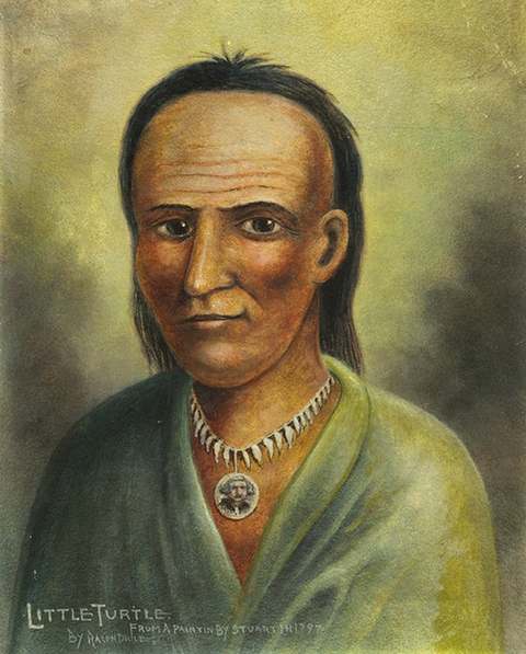
Fort Recovery sits on the single most significant Native American historical site in Mercer County: the ground where, on November 4, 1791, a confederacy led by Little Turtle (Miami), Blue Jacket (Shawnee) and Buckongahelas (Lenape) destroyed General Arthur St. Clair's army, and where, on June 30, 1794, roughly 2,000 warriors under Blue Jacket and the Odawa leader Egushawa, with British support, besieged Anthony Wayne's rebuilt fort and were repelled. The 1795 Treaty of Greenville used the fort as one of its boundary reference points, fixing the line that ceded most of Ohio to the United States.
Nations recorded here: Miami, Shawnee, Lenape (Delaware), Ottawa.
- Fort Recovery Site / St. Clair's Defeat battlefield (battle) — village of Fort Recovery, State Route 49, 1791 (battle); 1793-1796 (fort) (en.wikipedia.org)
Timeline
- — St. Clair's Defeat destroys General Arthur St. Clair's army on this ground.
- — Anthony Wayne's Legion builds Fort Recovery on the battlefield, clearing unburied remains to make camp.
- — About 2,000 Native warriors and British allies besiege the roughly 250-man garrison; the Americans hold, using cannons recovered from the 1791 battlefield.
- — The Treaty of Greenville uses Fort Recovery as a boundary reference point.
- — The fort is abandoned.
- — Townspeople hold a formal Bone Burying Day, interring human remains still being turned up around the old battlefield.
- — A resident's grubbing hoe strikes roughly 900 Spanish doubloons buried near the fort, worth about $14,000.
- — Fort Recovery incorporates as a village.
- — A 101-foot granite obelisk memorializing the dead of both engagements is dedicated.
- — The Fort Recovery State Museum opens, with life-size dioramas and artifacts from Wayne's campaign.
Stories
Bones under the beds
When Anthony Wayne's Legion arrived at the site of St. Clair's Defeat in the autumn of 1793, two years had passed since roughly 1,000 American soldiers and camp followers had been killed or wounded there, and the ground had not been cleared. Soldiers building the new fort had to move human bones simply to find space to sleep. Wayne's deliberate choice to build directly on the old battlefield -- as much a psychological statement as a military one -- paid off the following June, when the fort's small garrison withstood a siege by a Native and British-allied force many times its size, helped along by cannons the Americans dug out of the same ground that had swallowed St. Clair's army. Even after the fort was abandoned in 1796, the bones kept surfacing; the town held a formal Bone Burying Day in September 1851 to finally inter what remained, and the next year a resident's grubbing hoe turned up a very different kind of buried treasure, roughly 900 Spanish gold doubloons worth about $14,000.
The worst defeat becomes a boundary line
St. Clair's Defeat cost the United States close to a quarter of its entire standing army in a single morning, and for a time it threatened to unravel American settlement of the entire Northwest Territory. But the site's second act reversed its meaning entirely: the fort Wayne built there in 1793 survived a major siege in 1794, Wayne went on to defeat the same confederacy decisively at Fallen Timbers weeks later, and when the Treaty of Greenville was signed in August 1795, its negotiators used Fort Recovery itself -- the site of the army's worst humiliation -- as one of the fixed points defining the new line between the United States and Native land. A place that had marked American military failure became, within four years, a literal marker of American territorial gain.
Photographs
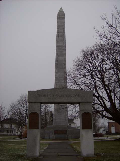
Photo: Nyttend, public domain · Wikimedia Commons
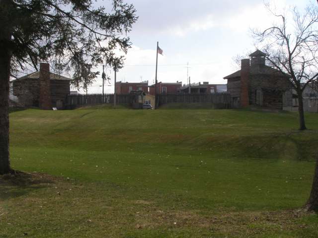
Photo: Chris Light, CC BY-SA 4.0 · Wikimedia Commons
Local history sources: en.wikipedia.org · en.wikipedia.org · en.wikipedia.org · en.wikipedia.org · commons.wikimedia.org · commons.wikimedia.org
Historic places
1 place in Fort Recovery on the National Register of Historic Places. Press a pin or a name for its whole record.
-
Fort Recovery SiteSite · Fort Recovery · listed 1970
- Address
- OH 49
- Where
- Fort Recovery, Mercer County · ZIP 45846
- What it is
- Site
- Listed on the National Register
- 1970
- NRIS reference number
- 70000509
- Coordinates
- 40.41402, -84.78081
National Register file (NPS) ↗ Search Wikipedia ↗ Street map and directions ↗ On the Cracked Buckeye map
Source: National Park Service, National Register of Historic Places point file. The listing year is shown where NPS's certification date agrees with the listing's reference number. Listing recognizes significance; it does not restrict a private owner.
Water
Mostly private wells The water here
- Ft Recovery Village100% of residentsGroundwater wells (2 wells)
Hospitals, fire stations and more
Inside Fort Recovery's boundary: 1 fire or EMS station, 3 public schools, 1 library, 1 police station, 3 Toxics Release Inventory facilities and 2 spill cases. Press a pin or a name for its whole record and its source.
Fire and EMS stations (1)
-
Southwest Mercer Fire DistrictFort Recovery
- Address
- 111 South Main Street, Fort Recovery, OH 45846
- Coordinates
- 40.41213, -84.77788
USGS National Map structures (source) ↗ Street map and directions ↗
Source: USGS National Map structures (most Ohio records last updated 2019 to 2022), checked against the Columbus and Cleveland station lists. The department that answers a call is set by jurisdiction and mutual aid, not by distance.
Public schools (3)
-
Fort Recovery Elementary School4.5 of 5 stars · Fort Recovery
- Address
- 865 Sharpsburg Rd, Fort Recovery, OH 45846
- School district
- Fort Recovery Local School District
- Kind (NCES)
- Regular School
- Students, 2023-24
- 510
- Teachers (full-time equivalent)
- 26.85
- Report card, 2025-26
- 4.5 of 5 stars
- Performance index
- 94.6%
- Ohio building IRN
- 040311
- NCES school ID
- 390485903312
NCES school record ↗ Ohio School Report Card ↗ Street map and directions ↗
-
Fort Recovery High School5 of 5 stars · Fort Recovery
- Address
- 400 East Butler Street, Fort Recovery, OH 45846
- School district
- Fort Recovery Local School District
- Kind (NCES)
- Regular School
- Students, 2023-24
- 322
- Teachers (full-time equivalent)
- 15.15
- Report card, 2025-26
- 5 of 5 stars
- Performance index
- 95.6%
- Four-year graduation rate
- 100%
- Ohio building IRN
- 012674
- NCES school ID
- 390485903309
NCES school record ↗ Ohio School Report Card ↗ Street map and directions ↗
-
Fort Recovery Middle School5 of 5 stars · Fort Recovery
- Address
- 865 Sharpsburg Rd, Fort Recovery, OH 45846
- School district
- Fort Recovery Local School District
- Kind (NCES)
- Regular School
- Students, 2023-24
- 187
- Teachers (full-time equivalent)
- 10.15
- Report card, 2025-26
- 5 of 5 stars
- Performance index
- 92.2%
- Ohio building IRN
- 009324
- NCES school ID
- 390485903308
NCES school record ↗ Ohio School Report Card ↗ Street map and directions ↗
Source: NCES EDGE public school locations 2024-25 and Common Core of Data 2023-24 (type, students, teachers); Ohio School Report Cards 2025-26 (Department of Education and Workforce), matched by name within the district.
Public libraries (1)
-
Fort Recovery Public LibraryCentral library · Fort Recovery
- Address
- 113 N. Wayne St., Fort Recovery, OH 45846
- What it is
- Central library
- Library system
- Fort Recovery Public Library
- Open
- 1,898 hours a year, 52 weeks
- Building
- 3,829 sq ft
- System's visits, FY2024
- 17,108
- System's loans, FY2024
- 52,573
- People the system serves
- 4,113
- Phone
- (419) 375-2869
IMLS Public Libraries Survey (source) ↗ Street map and directions ↗
Source: IMLS Public Libraries Survey FY2024 (outlets and their systems). Any Ohio resident can get a free card at any Ohio public library.
Police stations (1)
-
Fort Recovery Police DepartmentFort Recovery
- Address
- 201 South Main Street, Fort Recovery, OH 45846
- Coordinates
- 40.41105, -84.77809
USGS National Map structures (source) ↗ Street map and directions ↗
Source: USGS National Map structures, police stations, corrected and completed by hand (September 2026). The department that answers a call is set by jurisdiction, not by distance.
Facilities reporting toxic releases (3)
-
Cooper Farms East MillToxics Release Inventory · Fort Recovery
- Address
- 2351 Wabash Rd, Fort Recovery, OH 45846
- County
- Mercer County County
- Status
- Reports to the Toxics Release Inventory (active)
- EPA program ID
- 4584WCPRFR2351W
- EPA registry ID
- 110067662069
EPA facility record ↗ EPA Facility Registry Service (source) ↗ Street map and directions ↗
-
Cooper Farms IncToxics Release Inventory · Fort Recovery
- Address
- 2321 State Route 49, Fort Recovery, OH 45846
- County
- Mercer County
- Status
- Reports to the Toxics Release Inventory (active)
- EPA program ID
- 45846CPRFR2321S
- EPA registry ID
- 110002352052
EPA facility record ↗ EPA Facility Registry Service (source) ↗ Street map and directions ↗
-
J & M Mfg Co Inc (0354000124)Toxics Release Inventory · Fort Recovery
- Address
- 284 Railroad Street, Fort Recovery, OH 45846
- County
- Mercer County
- Status
- Reports to the Toxics Release Inventory (active)
- EPA program ID
- 45846JMMNF284RA
- EPA registry ID
- 110000766975
EPA facility record ↗ EPA Facility Registry Service (source) ↗ Street map and directions ↗
Source: EPA Facility Registry Service, Toxics Release Inventory reporters. Reporting a release is required of large users of listed chemicals; it is not by itself a violation.
Spills reported since 2021 (2)
-
Sewage Sludge / Biosolids2024-05-28 · Ft Recovery
- Reported
- 2024-05-28
- What spilled
- Sewage Sludge / Biosolids
- Where
- Ft Recovery, Mercer County
- Ohio EPA district office
- NWDO
- Ohio EPA case number
- 2405EPA0000894
Ohio EPA spill reports (source) ↗ Street map and directions ↗
-
Fuel Diesel / Diesel Fuel (Vehicle On Or Off Road) Reached water2023-11-02 · Ft Recovery
- Reported
- 2023-11-02
- What spilled
- Fuel Diesel / Diesel Fuel (Vehicle On Or Off Road)
- Reached a waterway
- 99 - Unnamed
- Where
- Ft Recovery, Mercer County
- Ohio EPA district office
- NWDO
- Ohio EPA case number
- 2311EPA0001874
Ohio EPA spill reports (source) ↗ Street map and directions ↗
Source: Ohio EPA emergency response spill reports, 2021 to September 2026, one point per case where Ohio EPA placed it. A report is what the caller or responder recorded; amounts are often blank or estimated.
Its ZIP codes
Each ZIP code that touches Fort Recovery, with the share of its residents who live here and the same headline figures as the ZIP page.
| ZIP | Share | Water | Radon | Home value | Schools | Flood |
|---|---|---|---|---|---|---|
| 45846 Fort Recovery | 34% | Mostly private wells | 2.2 pCi/L average radon | Median year built 1974 | Fort Recovery Local · 5 stars overall | 7.3% of residents in the 1% floodplain |
Local government
Who holds office in Fort Recovery, how its elections and ballot issues came out, and the state auditor's record.
Money issues on the ballot since 2023: 2 of 2 passed.
Ballot issues
| Date | Issue | For | Against | Result |
|---|---|---|---|---|
| 2025-11-04 | Issue: Village of Fort Recovery Income Tax | 170 | 63 | Passed (72.96% for) |
| 2023-11-07 | Issue: Village of Fort Recovery (Renewal) | 432 | 128 | Passed (77.14% for) |
Elections for office
| Date | Office | Candidates and votes |
|---|---|---|
| 2025-11-04 | Member of Council | Greg Schmitz 201, 50.63%; Luke Knapke 196, 49.37% |
| 2023-11-07 | Member of Council | Allen Post 426, 51.45%; Scott Pearson 402, 48.55% |
| 2023-11-07 | Mayor | Dave Kaup 506, 100.0% |
Winners in bold. Results from the county board of elections' official canvass unless marked.
Auditor of State record
- No fiscal caution, watch or emergency on the Auditor of State's lists.
- Financial Audit, 2024, released 2026-01-20
- Agreed Upon Procedures, 2022 to 2023, released 2024-10-03
The county
Mercer County: 10 ZIP codes, 23 cities, villages and townships, 42,566 people.
Nearby places
Rain and snow
How much has actually fallen on Fort Recovery, day by day, from 1893 to now. Daily totals, not averages.
- rain, last 30 days
- 0.48 in
- 2026-09-30 to 2026-10-29
- rain so far in 2026
- 37.7 in
- 3.3 in above normal for the date
- snow so far in 2026
- 14.8 in
- a normal year brings 17.9 in
- a normal year
- 40.2 in
- average of 30 years, 1991-2020
| Month | Rain (in) | Snow (in) | Days counted |
|---|---|---|---|
| October 2026 | 0.48 | — | 29 |
| September 2026 | 5.61 | — | 30 |
| August 2026 | 9.40 | — | 31 |
| July 2026 | 3.02 | — | 31 |
| June 2026 | 3.43 | — | 30 |
| May 2026 | 4.45 | — | 31 |
| April 2026 | 4.04 | — | 30 |
| March 2026 | 5.49 | 1.0 | 31 |
| February 2026 | 0.76 | 4.2 | 28 |
| January 2026 | 1.03 | 9.5 | 31 |
| December 2025 | 1.47 | 7.3 | 31 |
| November 2025 | 1.50 | 3.3 | 30 |
| Wettest year | 2003 — 57.5 in |
|---|---|
| Driest year | 1908 — 23.2 in |
| Snowiest year | 1912 — 53.8 in |
| Wettest day on record | 28 June 1957 — 4.57 in |
| Heaviest snowfall in a day | 14 February 2007 — 10.66 in |
| Deepest snow on the ground | 6 January 1903 — 21.52 in |
Mostly estimated. Only 19% of these days come from a gauge standing inside Fort Recovery - the rest are worked out from the nearest gauges around it, so read them as close estimates rather than readings.
48,263 days of records, 1893-01-01 to 2026-10-29. Source: NOAA NCEI GHCN-Daily, 3,240 gauges in and around Ohio. A day is "gauged" when a gauge standing inside the boundary reported it, and the value is the mean of those gauges. Otherwise it is interpolated by inverse distance from every gauge reporting within 50 miles. Nothing is carried forward, back-filled or smoothed. Against NOAA nClimDiv county monthly precipitation over 136,848 complete county-months (checked 2026-10-31): correlation 0.9515, median absolute difference 0.217 in a month. Built 2026-10-31 from the Cracked Buckeye precipitation archive. Snow is the softer number — snowfall is measured by hand with a ruler, no agency publishes a gridded county snowfall series, and blowing snow defeats every observer.
Environmental permits and filings
What Ohio EPA has on file for Fort Recovery: permits, inspections, violations, cleanups and the state loans behind sewer and water work. Every line links to the agency's own document.
- facilities and sites on file
- 9
- those placed on the map inside Fort Recovery
| Program | Facilities and sites |
|---|---|
| Voluntary cleanup | 4 |
| Air pollution | 1 |
| Hazardous waste | 1 |
| Public drinking water | 1 |
| State sewer loans | 1 |
| State water loans | 1 |
| Date | Facility or site | What |
|---|---|---|
| FT RECOVERY VILLAGE PWS | Public drinking water plan | |
| FT RECOVERY VILLAGE PWS | Public drinking water plan | |
| FT RECOVERY VILLAGE PWS | Public drinking water compliance letter | |
| FT RECOVERY VILLAGE PWS | Public drinking water notice of violation | |
| FT RECOVERY VILLAGE PWS | Public drinking water plan | |
| FORT RECOVERY WWTP | State sewer loans | |
| FT RECOVERY VILLAGE PWS | Public drinking water report | |
| FORT RECOVERY WWTP | State sewer loans | |
| FT RECOVERY VILLAGE PWS | Public drinking water violation resolved | |
| FT RECOVERY VILLAGE PWS | Public drinking water plan | |
| FT RECOVERY VILLAGE PWS | Public drinking water inspection | |
| FT RECOVERY VILLAGE PWS | Public drinking water monitoring results | |
| FT RECOVERY VILLAGE PWS | Public drinking water plan | |
| FT RECOVERY VILLAGE PWS | Public drinking water plan | |
| FT RECOVERY VILLAGE PWS | Public drinking water inspection | |
| FT RECOVERY VILLAGE PWS | Public drinking water inspection | |
| FT RECOVERY VILLAGE PWS | Public drinking water inspection | |
| FT RECOVERY VILLAGE PWS | Public drinking water inspection | |
| FT RECOVERY VILLAGE PWS | Public drinking water report | |
| FT RECOVERY VILLAGE PWS | Public drinking water notice of violation | |
| FT RECOVERY VILLAGE PWS | Public drinking water compliance letter | |
| FT RECOVERY VILLAGE PWS | Public drinking water compliance letter | |
| FT RECOVERY VILLAGE PWS | Public drinking water monitoring results | |
| FT RECOVERY VILLAGE PWS | Public drinking water report | |
| FT RECOVERY VILLAGE PWS | Public drinking water notice of violation |
Source: Ohio EPA eDocument portal (edocpub.epa.ohio.gov), indexed 2026-10-14. Facilities are placed on the map from Ohio EPA's own map layers, EPA's Facility Registry, coordinates written in the filings, or a geocoded street address. A permit filed under a private person's name (most are household septic systems) is counted but never named, placed or linked; licenses for individual workers and open-burning notices are left out entirely.
Quick answers
What county is Fort Recovery, Ohio in?
Fort Recovery is a village in Mercer County, Ohio, with 1,501 residents.
When was Fort Recovery, Ohio founded?
Fort Recovery was settled 1793 (fort); continuous settlement since; incorporated 1858. Founders on record: General Anthony Wayne (fort); civilian village grew up around it. Source
How did Fort Recovery, Ohio get its name?
Named by Anthony Wayne for the army's 'recovery' of the ground -- and its lost cannons -- where St. Source
What ZIP code is Fort Recovery, Ohio?
Most of Fort Recovery is in ZIP code 45846.
Where does Fort Recovery, Ohio get its water?
The main water source for Fort Recovery (Ft Recovery Village): Mostly private wells.
Cite this page
Cite this page as:
Cracked Buckeye, "Fort Recovery, Mercer County", https://crackedbuckeye.com/place/fort-recovery/, built 2026-10-31, accessed [date].
How to cite · Report a correction · Built 2026-10-31
