Local events in Gibson Township, Mercer County
Nothing is posted for Gibson Township itself yet; here is what is on within 20 miles. All local events in Gibson Township, Mercer County
Know a calendar we should watch? Send the link
Checked October 20; the events page is refreshed daily.
How Gibson Township, Mercer County began
Gibson Township, in the southwest corner of Mercer County, began as a township of Darke County and was transferred to Mercer County in 1848 or 1849; its irregular northern boundary is the old Greenville Treaty Line, which bends at Fort Recovery. The Wabash River rises in the Hog Prairie south of Fort Recovery and loops about 60 miles before returning within four miles of its source, and near Sharpsburg stands the only prehistoric mound recorded in the county. Settlers from southern Ohio, Pennsylvania and Delaware took the west and south, and a German Catholic community grew in the east around St. Paul's Church at Sharpsburg, founded in 1868. Part of the village of Fort Recovery extends into its northwestern corner.
Settled 1830s (George Hedrick and William Snyder, 1835), incorporated as a Darke County township: 1834 (first election, per the 1959 Mercer history) or 1836 (detached from Jackson Township, per the 1914 Darke history); transferred to Mercer County 1848 or 1849, by Darke County commissioners; transferred to Mercer County by the state.
Where the name comes from
The only Gibson Township in Ohio; no source for the specific naming was found.
Before the town
Gibson Township holds the only prehistoric mound recorded in Mercer County: the Mercer County Historical Society's 1959 history places it in section 25, about half a mile north of Sharpsburg on the Stammen farm, 18 to 20 feet high and several hundred feet across, looking like a smooth rounded knoll with a road cut through one end, and attributes it, with the county's other earthworks, to the Hopewell culture. The same history records that when Azariah Denney came to the township with his parents at age ten, 26 families of Miami were camped on Simison's Run, and the Miami boys were his playmates. The township's northern boundary follows the Greenville Treaty Line, the 1795 boundary between ceded land and Native country. Part of Fort Recovery, site of St. Clair's defeat in 1791 and the 1794 battle, extends into its northwest corner.
Nations recorded here: Miami, Shawnee, Lenape (Delaware), Ottawa, Hopewell culture.
- Sharpsburg mound (Stammen farm) (mound) — section 25, about half a mile north of Sharpsburg, attributed to the Hopewell culture (about 100 BC to AD 500) (archive.org)
- Miami camp on Simison's Run (camp) — Simison's Run, Gibson Township, early settlement years (date not given) (archive.org)
- Greenville Treaty Line (treaty) — northern boundary of the township, bending at Fort Recovery, 1795 (archive.org)
Timeline
- — Darke County erects Jackson Township, which includes the land of present Gibson Township.
- — The first Gibson Township election is held, per the 1959 Mercer County history.
- — George Hedrick and William Snyder arrive; John L. Fox and Thomas Rockwell follow in 1837 and John Hedrick in 1839.
- — Gibson Township is detached from Jackson Township in Darke County, per the 1914 Darke County history.
- — Gibson Township is transferred from Darke County to Mercer County, per the 1914 Darke County history; the Mercer histories give 1849.
- — Nathan S. Scranton, of a Connecticut family, settles on a farm in the township after coming from Medina County.
- — Fort Recovery, part of which extends into this township's northwest corner, incorporates as a village.
- — Bethel Evangelical Church, the township's first church, is organized in its western part.
- — St. Paul's Catholic Church is established at Sharpsburg.
- — The township has 1,462 residents; in 1900 it has 1,568.
- — The assessor returns 4,309 acres of cultivated land, 4,494 of pasture, 2,371 of woodland and 515 of waste land.
Stories
Where the Wabash begins
The Wabash River rises in the Hog Prairie, about four miles south of Fort Recovery on the line between Mercer and Darke counties. Scranton's 1907 history describes it leaving the prairie as no more than a small ditch, running south and east, then winding around to the north and west through Granville and Recovery townships until it reaches Fort Recovery, within four miles of its source, after about 60 miles of meandering. From there it flows north through Washington Township and west through Liberty Township into Indiana. The wet swales of Gibson Township were later drained by ditching and tile, and by 1907 the mud roads had been macadamized and log barns replaced with large frame barns.
Sharpsburg and Violet
Sharpsburg, in the southeast of Gibson Township, grew around a general store and St. Paul's Catholic Church, established in 1868, in a German Catholic neighborhood settled early by families such as the Roods, who came from Butler County, Ohio, and the Motts. The store was run for many years by George Zenz and in 1907 by his son John. A post office there, called Violet, closed when rural free delivery began. Half a mile north of the settlement, on the Stammen farm, is the mound that the Mercer County Historical Society in 1959 called the only one in the county.
Photographs
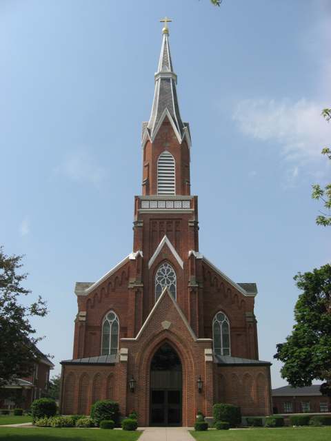
Photo: Nyttend (Wikimedia Commons), public domain · Wikimedia Commons
Local history sources: en.wikipedia.org · en.wikipedia.org · en.wikipedia.org · archive.org · archive.org · archive.org · archive.org · archive.org · en.wikipedia.org · archive.org · archive.org · commons.wikimedia.org
Historic places
1 place in Gibson Township, Mercer County on the National Register of Historic Places. Press a pin or a name for its whole record.
-
St. Paul's Catholic Church and RectoryBuilding · Sharpsburg · listed 1979
- Address
- R.R. 1, Ft. Recovery
- Where
- Sharpsburg, Mercer County · ZIP 45846
- What it is
- Building
- Listed on the National Register
- 1979
- NRIS reference number
- 79002827
- Coordinates
- 40.36727, -84.71145
National Register file (NPS) ↗ Search Wikipedia ↗ Street map and directions ↗ On the Cracked Buckeye map
Source: National Park Service, National Register of Historic Places point file. The listing year is shown where NPS's certification date agrees with the listing's reference number. Listing recognizes significance; it does not restrict a private owner.
Water
Mostly private wells The water here
- Ft Recovery Village100% of residentsGroundwater wells (2 wells)
Hospitals, fire stations and more
Inside Gibson Township, Mercer County's boundary: 1 high-hazard dam, 1 poor-rated bridge and 1 spill case. Press a pin or a name for its whole record and its source.
High-hazard dams (1)
-
Upper Wabash Structure No. 3 DamFort Creek · condition: satisfactory
- Hazard class
- High: a failure would probably cost a life
- Condition
- Satisfactory (assessed 05/19/2025)
- River or stream
- Fort Creek
- Purpose
- Flood Risk Reduction
- Type
- Earth
- Height
- 28 ft
- Storage
- 1,714 acre-feet
- Completed
- 1963
- Owner type
- Local Government
- County
- Mercer County
- Nearest town (NID)
- New Corydon
- Last inspection
- 11/07/2024
- Emergency action plan
- Yes
- NID ID
- OH00579
National Inventory of Dams record ↗ National Inventory of Dams (source) ↗ Street map and directions ↗
Source: U.S. Army Corps of Engineers National Inventory of Dams, August 2026. "High hazard" rates what a failure would cost downstream, not how likely one is; the condition is the state's assessment.
Bridges rated poor (1)
-
Sharpsburg Road over Branch of Wabash RiverPoor · built 1965
- Condition
- Poor: a deck, superstructure, substructure or culvert rated 4 or below on the 0 to 9 scale
- What it is
- Bridge
- Built
- 1965
- Length
- 11 ft
- Owner
- County
- Vehicles a day
- 723
- Coordinates
- 40.37149, -84.71631
National Bridge Inventory (source) ↗ Street map and directions ↗
Source: FHWA National Bridge Inventory 2025. "Poor" means one major part rated 4 or below on the 0 to 9 scale; it calls for repair, not closing, unless the state posts or closes the bridge.
Spills reported since 2021 (1)
-
Material Undetermined / Other Reached water2021-06-16 · Gibson Twp
- Reported
- 2021-06-16
- What spilled
- Material Undetermined / Other
- Reached a waterway
- 99 - Unnamed
- Where
- Gibson Twp, Mercer County
- Ohio EPA district office
- NWDO
- Ohio EPA case number
- 2106EPA0000871
Ohio EPA spill reports (source) ↗ Street map and directions ↗
Source: Ohio EPA emergency response spill reports, 2021 to September 2026, one point per case where Ohio EPA placed it. A report is what the caller or responder recorded; amounts are often blank or estimated.
Its ZIP codes
Each ZIP code that touches Gibson Township, Mercer County, with the share of its residents who live here and the same headline figures as the ZIP page.
| ZIP | Share | Water | Radon | Home value | Schools | Flood |
|---|---|---|---|---|---|---|
| 45846 Fort Recovery | 22% | Mostly private wells | 2.2 pCi/L average radon | Median year built 1974 | Fort Recovery Local · 5 stars overall | 7.3% of residents in the 1% floodplain |
Local government
Who holds office in Gibson Township, Mercer County, how its elections and ballot issues came out, and the state auditor's record.
Elections for office
| Date | Office | Candidates and votes |
|---|---|---|
| 2025-11-04 | Trustee | Donald Kahlig 234, 51.77%; Gary Post 218, 48.23% |
| 2023-11-07 | Trustee | Mark Post 796, 100.0% |
| 2023-11-07 | Fiscal Officer | Wendy Rauh 766, 100.0% |
Winners in bold. Results from the county board of elections' official canvass unless marked.
Auditor of State record
- No fiscal caution, watch or emergency on the Auditor of State's lists.
- Basic Audit, 2024 to 2025, released 2026-06-18
- Agreed Upon Procedures, 2022 to 2023, released 2025-02-18
The county
Mercer County: 10 ZIP codes, 23 cities, villages and townships, 42,566 people.
Nearby places
Quick answers
What county is Gibson Township, Ohio in?
Gibson Township, Mercer County is a township in Mercer County, Ohio, with 992 residents.
When was Gibson Township, Ohio founded?
Gibson Township, Mercer County was settled 1830s (George Hedrick and William Snyder, 1835); incorporated as a Darke County township: 1834 (first election, per the 1959 Mercer history) or 1836 (detached from Jackson Township, per the 1914 Darke history); transferred to Mercer County 1848 or 1849. Founders on record: Darke County commissioners; transferred to Mercer County by the state. Source
How did Gibson Township, Ohio get its name?
The only Gibson Township in Ohio; no source for the specific naming was found. Source
What ZIP code is Gibson Township, Ohio?
Most of Gibson Township, Mercer County is in ZIP code 45846.
Where does Gibson Township, Ohio get its water?
The main water source for Gibson Township, Mercer County (Ft Recovery Village): Mostly private wells.
Cite this page
Cite this page as:
Cracked Buckeye, "Gibson Township, Mercer County", https://crackedbuckeye.com/place/gibson-township-mercer-county/, built 2026-10-31, accessed [date].
How to cite · Report a correction · Built 2026-10-31
