Local events in Deshler
Nothing is posted for Deshler itself yet; here is what is on within 20 miles. All local events in Deshler
Know a calendar we should watch? Send the link
Checked October 20; the events page is refreshed daily.
History from Deshler
People and inventions tied to this place, each with its sources. All people · All inventions
How Deshler began
Deshler was platted in the southeastern corner of Henry County's Bartlow Township in August 1873 by Frederick H. Short and a syndicate of investors, and named for Columbus land owner John G. Deshler, who held roughly a quarter of the surrounding township for speculation. The village grew up where the Dayton and Michigan Railroad crossed the new Baltimore and Ohio line, becoming a lumber and stave-manufacturing center as the surrounding Black Swamp forest was cleared, and incorporated in 1876. Its position at the crossing of two major B&O routes later earned it the nickname 'The Crossroads of the B&O,' and the railroad remains central to the village's identity, drawing rail enthusiasts to watch trains at the diamond crossing.
Platted August 23, 1873, by Frederick H. Short for himself and a syndicate including John G. Deshler, incorporated April 30, 1876, by Frederick H. Short, Daniel McLane, Stephen S. L'Hommedieu, William Beckett, William E. Boven, Theodore Stanwood, John W. Hartwell and John G. Deshler.
Where the name comes from
The village was named for John G. Deshler of Columbus, the large non-resident land owner who held about a quarter of surrounding Bartlow Township for speculation and was among the platting syndicate; a post office bearing the name had already opened in 1872, a year before the formal plat.
Before the town
No Native village, camp, trail or treaty event specific to the Deshler town site is recorded in the sources consulted; Bartlow Township, where Deshler sits, was still uncleared Black Swamp forest through the 1830s Native-removal era and was not organized as a township until 1854, two decades after the last documented Native residents left Henry County. Elsewhere in Henry County, the record includes the Ottawa reservation in Washington Township.
Timeline
- — A post office named Deshler opens at the newly platted town site, at the junction of the Cincinnati, Hamilton & Dayton (formerly Dayton & Michigan) Railroad and the Baltimore and Ohio.
- — Frederick H. Short records the original plat of Deshler, 200 lots and two public squares, for himself and a syndicate that includes John G. Deshler.
- — The village of Deshler is formally incorporated.
- — Deshler's industries by this date include a stave factory, a sawmill producing about 2,000,000 feet of sycamore lumber a year for tobacco boxes, a machine shop and foundry, and a brick and tile works.
- — Deshler's population peaks at 1,938 residents.
- — President Ronald Reagan makes a whistle-stop appearance in Deshler aboard the Ferdinand Magellan railcar during his re-election campaign.
- — Deshler's old railroad depot is demolished.
Stories
A reservoir town built on the swamp
Deshler's site began as nothing more than a railroad watering hole: when the Dayton and Michigan Railroad was built through the dense, wet Black Swamp forest of Bartlow Township, its builders dug a large reservoir to feed the locomotives, fed by Brush Creek, and the railroad named the stop Alma. Nine-tenths of the surrounding land belonged to non-resident speculators, chief among them Columbus's John G. Deshler, who held it for future value rather than sale, and there were no roads to any market. The real change came with the 1869 construction of the Baltimore and Ohio Railroad through the same spot; a supply store went up for the construction crews, and by 1873 the site was platted as a town and named for its largest landowner. Within fifteen years the reservoir town had two railroads, two hundred platted lots, a five-thousand-dollar brick schoolhouse, three churches, a weekly newspaper and a machine shop, foundry, stave factory and saw-mill turning the last of the swamp's timber into tobacco boxes and lumber -- a transformation the county historian, quoting an old joke written about a rival town, called wonderful enough that 'Aladdin's lamp seems a possibility.'
Photographs
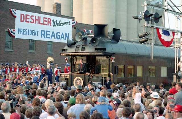
Photo: Ronald Reagan Presidential Library / White House Photographic Office, public domain · Wikimedia Commons
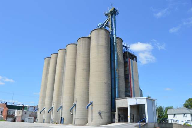
Photo: Nyttend, public domain · Wikimedia Commons
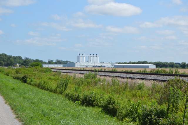
Photo: Nyttend, public domain · Wikimedia Commons
Local history sources: archive.org · archive.org · en.wikipedia.org · commons.wikimedia.org · commons.wikimedia.org · commons.wikimedia.org
Water
Groundwater wells (2 wells) The water here
- Deshler Village100% of residentsGroundwater wells (2 wells)
Hospitals, fire stations and more
Inside Deshler's boundary: 1 fire or EMS station, 1 library, 1 museum, 1 police station, 1 Superfund site and 1 Toxics Release Inventory facility. Press a pin or a name for its whole record and its source.
Fire and EMS stations (1)
-
Deshler Fire DepartmentDeshler
- Address
- 126 East Main Street, Deshler, OH 43516
- Coordinates
- 41.20647, -83.90058
USGS National Map structures (source) ↗ Street map and directions ↗
Source: USGS National Map structures (most Ohio records last updated 2019 to 2022), checked against the Columbus and Cleveland station lists. The department that answers a call is set by jurisdiction and mutual aid, not by distance.
Public libraries (1)
-
Patrick Henry School District Public LibraryCentral library · Deshler
- Address
- 208 N. East Ave., Deshler, OH 43516
- What it is
- Central library
- Library system
- Patrick Henry School District Public Library
- Open
- 2,704 hours a year, 52 weeks
- Building
- 1,400 sq ft
- System's visits, FY2024
- 14,300
- System's loans, FY2024
- 51,397
- People the system serves
- 5,178
- Phone
- (419) 278-3616
IMLS Public Libraries Survey (source) ↗ Street map and directions ↗
Source: IMLS Public Libraries Survey FY2024 (outlets and their systems). Any Ohio resident can get a free card at any Ohio public library.
Museums, historical societies, gardens and zoos (1)
-
Bartlow Township Historical SocietyHistorical society · Deshler
- What it is
- Historical society
- City
- Deshler
- Coordinates
- 41.20786, -83.89603
Search Wikipedia ↗ IMLS Museum Data Files (source) ↗ Street map and directions ↗
The museum list is IMLS's 2018 file; a museum may have closed or moved since.
Source: IMLS Museum Data Files, 2018.
Police stations (1)
-
Deshler Village Police DepartmentDeshler
- Address
- 101 East Main Street, Deshler, OH 43516
- Coordinates
- 41.20719, -83.90091
USGS National Map structures (source) ↗ Street map and directions ↗
Source: USGS National Map structures, police stations, corrected and completed by hand (September 2026). The department that answers a call is set by jurisdiction, not by distance.
Superfund sites (1)
-
Deshler LeadSuperfund program · Deshler
- Address
- 223 W Marion St, Deshler, OH 43516
- County
- Henry County
- Status
- Superfund program site, not on the National Priorities List
- EPA program ID
- OH0001475144
- EPA registry ID
- 110000850231
EPA facility record ↗ EPA Facility Registry Service (source) ↗ Street map and directions ↗
Source: EPA Facility Registry Service, Superfund (SEMS) and National Priorities List sites. Many program sites were assessed and needed no cleanup.
Facilities reporting toxic releases (1)
-
Metal Forge CoToxics Release Inventory · Deshler
- Address
- 320 S. Vine St., Deshler, OH 43516
- County
- Henry County
- Status
- Reports to the Toxics Release Inventory (closed)
- EPA program ID
- 43516MTLFR320SV
- EPA registry ID
- 110000383585
EPA facility record ↗ EPA Facility Registry Service (source) ↗ Street map and directions ↗
Source: EPA Facility Registry Service, Toxics Release Inventory reporters. Reporting a release is required of large users of listed chemicals; it is not by itself a violation.
Its ZIP codes
Each ZIP code that touches Deshler, with the share of its residents who live here and the same headline figures as the ZIP page.
| ZIP | Share | Water | Radon | Home value | Schools | Flood |
|---|---|---|---|---|---|---|
| 43516 Deshler | 57% | Groundwater wells (2 wells) | 5.3 pCi/L average radon | Median year built 1950 | Patrick Henry Local · 4.5 stars overall | No digital FEMA flood map for this county |
Local government
Who holds office in Deshler, how its elections and ballot issues came out, and the state auditor's record.
Who holds office
| Office | Name | Party | Term ends | Contact |
|---|---|---|---|---|
| Mayor | Michael W. Woods | 419-278-3831 507 West Main Street, Deshler, OH 43516 |
Roster as of 2026-09-17: county board of elections.
Elections for office
| Date | Office | Candidates and votes |
|---|---|---|
| 2025-11-04 | Member of the Board of Public Affairs | Brian A. Yarnell 243, 100.0% |
| 2025-11-04 | Member of Council | Randy G. Petersen 221, 25.14%; Todd Petersen 210, 23.89%; Kolby F. Seemann 233, 26.51%; Clint Smith 215, 24.46% |
Winners in bold. Results from the county board of elections' official canvass unless marked.
Auditor of State record
- No fiscal caution, watch or emergency on the Auditor of State's lists.
- Financial Audit, 2022 to 2023, released 2024-11-07
The county
Henry County: 11 ZIP codes, 23 cities, villages and townships, 27,623 people.
Nearby places
Rain and snow
How much has actually fallen on Deshler, day by day, from 1893 to now. Daily totals, not averages.
- rain, last 30 days
- 1.28 in
- 2026-10-01 to 2026-10-30
- rain so far in 2026
- 32.0 in
- about normal for the date
- snow so far in 2026
- 15.0 in
- a normal year brings 25.2 in
- a normal year
- 36.9 in
- average of 30 years, 1991-2020
| Month | Rain (in) | Snow (in) | Days counted |
|---|---|---|---|
| October 2026 | 1.28 | — | 30 |
| September 2026 | 3.30 | — | 30 |
| August 2026 | 4.95 | — | 31 |
| July 2026 | 3.12 | — | 31 |
| June 2026 | 3.65 | — | 30 |
| May 2026 | 3.30 | — | 31 |
| April 2026 | 6.93 | — | 30 |
| March 2026 | 3.83 | 0.5 | 31 |
| February 2026 | 0.54 | 2.9 | 28 |
| January 2026 | 1.11 | 11.6 | 31 |
| December 2025 | 1.65 | 7.4 | 31 |
| November 2025 | 1.41 | 5.3 | 30 |
| Wettest year | 2011 — 52.7 in |
|---|---|
| Driest year | 1963 — 23.6 in |
| Snowiest year | 2014 — 61.4 in |
| Wettest day on record | 1 September 1959 — 3.20 in |
| Heaviest snowfall in a day | 16 November 1932 — 11.60 in |
| Deepest snow on the ground | 12 January 1918 — 22.01 in |
Estimated, not measured. No rain gauge has ever stood inside Deshler, so every figure here is worked out from the gauges around it - the nearest ones weighted most. Treat them as close estimates rather than readings.
48,819 days of records, 1893-01-01 to 2026-10-30. Source: NOAA NCEI GHCN-Daily, 3,240 gauges in and around Ohio. A day is "gauged" when a gauge standing inside the boundary reported it, and the value is the mean of those gauges. Otherwise it is interpolated by inverse distance from every gauge reporting within 50 miles. Nothing is carried forward, back-filled or smoothed. Against NOAA nClimDiv county monthly precipitation over 136,848 complete county-months (checked 2026-11-01): correlation 0.9515, median absolute difference 0.217 in a month. Built 2026-11-01 from the Cracked Buckeye precipitation archive. Snow is the softer number — snowfall is measured by hand with a ruler, no agency publishes a gridded county snowfall series, and blowing snow defeats every observer.
Environmental permits and filings
What Ohio EPA has on file for Deshler: permits, inspections, violations, cleanups and the state loans behind sewer and water work. Every line links to the agency's own document.
- facilities and sites on file
- 9
- those placed on the map inside Deshler
| Program | Facilities and sites |
|---|---|
| Hazardous waste | 3 |
| Air pollution | 2 |
| Public drinking water | 1 |
| State water loans | 1 |
| Wastewater and stormwater discharge | 1 |
| Wetland and stream fill | 1 |
| Date | Facility or site | What |
|---|---|---|
| DESHLER VILLAGE PWS | Public drinking water violation resolved | |
| DESHLER WTP 2 | Public drinking water violation resolved | |
| DESHLER VILLAGE PWS | Public drinking water notice of violation | |
| DESHLER VILLAGE PWS | Public drinking water notice of violation | |
| DESHLER VILLAGE PWS | Public drinking water report | |
| THE FARM | Wastewater and stormwater discharge permit | |
| AMP TRANSMISSION BREMER- SAND RIDGE 69KV LINE | Wetland and stream fill permit | |
| THE FARM | Wastewater and stormwater discharge violation resolved | |
| DESHLER VILLAGE PWS | Public drinking water plan | |
| DESHLER VILLAGE PWS | Public drinking water inspection | |
| THE FARM | Wastewater and stormwater discharge notice of violation | |
| THE FARM | Wastewater and stormwater discharge permit | |
| DESHLER VILLAGE PWS | Public drinking water report | |
| DESHLER VILLAGE PWS | Public drinking water compliance letter | |
| DESHLER VILLAGE PWS | Public drinking water notice of violation | |
| DESHLER VILLAGE PWS | Public drinking water inspection | |
| DESHLER VILLAGE PWS | Public drinking water inspection | |
| THE FARM | Wastewater and stormwater discharge permit | |
| THE FARM | Wastewater and stormwater discharge permit | |
| DESHLER VILLAGE PWS | Public drinking water compliance letter | |
| DESHLER VILLAGE PWS | Public drinking water compliance letter | |
| DESHLER VILLAGE PWS | Public drinking water report | |
| DESHLER VILLAGE PWS | Public drinking water compliance letter | |
| DESHLER VILLAGE PWS | Public drinking water permit | |
| DESHLER VILLAGE PWS | Public drinking water report |
Source: Ohio EPA eDocument portal (edocpub.epa.ohio.gov), indexed 2026-10-14. Facilities are placed on the map from Ohio EPA's own map layers, EPA's Facility Registry, coordinates written in the filings, or a geocoded street address. A permit filed under a private person's name (most are household septic systems) is counted but never named, placed or linked; licenses for individual workers and open-burning notices are left out entirely.
Quick answers
What county is Deshler, Ohio in?
Deshler is a village in Henry County, Ohio, with 1,588 residents.
When was Deshler, Ohio founded?
Deshler was laid out August 23, 1873, by Frederick H. Short for himself and a syndicate including John G. Deshler; incorporated April 30, 1876. Founders on record: Frederick H. Short, Daniel McLane, Stephen S. L'Hommedieu, William Beckett, William E. Boven, Theodore Stanwood, John W. Hartwell and John G. Deshler. Source
How did Deshler, Ohio get its name?
The village was named for John G. Source
What ZIP code is Deshler, Ohio?
Most of Deshler is in ZIP code 43516.
Where does Deshler, Ohio get its water?
The main water source for Deshler (Deshler Village): Groundwater wells (2 wells).
Cite this page
Cite this page as:
Cracked Buckeye, "Deshler, Henry County", https://crackedbuckeye.com/place/deshler/, built 2026-10-31, accessed [date].
How to cite · Report a correction · Built 2026-10-31