Local events in Deercreek Township, Madison County
Nothing is posted for Deercreek Township itself yet; here is what is on within 10 miles. All local events in Deercreek Township, Madison County
Know a calendar we should watch? Send the link
Checked October 20; the events page is refreshed daily.
How Deercreek Township, Madison County began
Deer Creek Township, in the center of Madison County, was erected by the county commissioners on April 30, 1810 and re-erected with new bounds on June 11, 1811. It takes its name from Deer Creek, which the 1883 county history says was believed named for the vast herds of deer that once resorted to it. John Adair was probably the first settler, about 1802, and Thomas Gwynne laid out the town of Lawrenceville, called Limerick, in 1816 on the old Columbus-Springfield mud road. When the National Road was completed through the township in 1836-37 it bypassed Lawrenceville, and William Minter laid out Lafayette beside it; the Red Brick Tavern there is on the National Register. The township had 967 residents in 2020.
Platted 1834 (Lafayette; the 1883 county history gives 1837), by William Minter, who platted Lafayette on the site of the earlier settlement of Lawrenceville.
Where the name comes from
The 1883 county history says the name Deer Creek 'originated, it is believed, from the fact that in early days it was the resort of vast herds of deer'. It does not name Native people as the hunters.
Before the town
No village, camp or burial site specific to Deer Creek Township is recorded in the sources checked. The 1883 county history says the prairies and thinly timbered parts of the township were often set on fire by the Indians in dry seasons, endangering the first settlers' property, and that Benjamin Garrett built a block house on Coniac Run in 1808 to protect his family from the Indians. The same history lists burial mounds in nearby Oak Run, Union, Pleasant and Jefferson townships; none is placed in Deer Creek Township. The township was part of the Shawnee and Wyandot country ceded in 1795.
Nations recorded here: Shawnee, Wyandot.
Timeline
- — John Adair camps on the bank of Deer Creek and then selects his site, probably the first settler in the township; he settles there in 1806.
- — William and John Blair, John Barr, John McCaul, Charles Ewing and others settle; they are the true pioneers of the township.
- — John McDonald settles at the Upper Glade, and Benjamin Garrett builds a block house on Coniac Run to protect his family from the Indians.
- — The Madison County commissioners erect Deer Creek Township; it is re-erected with new boundaries on June 11, 1811.
- — Charles Atchison is township treasurer, probably the first; a Methodist class is organized at the Upper Glade, giving the McDonald Church.
- — Thomas Gwynne laid out Lawrenceville about 1.5 miles northwest of what became Lafayette; it was the township's earliest platted settlement.
- — A post office is established at Lawrenceville.
- — William Minter platted the village of Lafayette, named for the Marquis de Lafayette, on ground the National Road would soon reach (the date Wikipedia gives; the 1883 county history says Minter began laying off lots in 1837).
- — The National Road was completed through the township but bypassed Lawrenceville, causing that older settlement to decline while Lafayette grew along the new highway; the Red Brick Tavern was built at Lafayette in the same years and was open by the time the road reached it.
- — The Lawrenceville post office is moved to Lafayette and takes its name, with John Minter as first postmaster.
- — William Minter, owner of the land, begins to lay off lots for Lafayette along the new National Road, according to the 1883 county history (Wikipedia gives the plat as October 1, 1834); the first house is built by Joseph Bell and Calvin Anderson keeps the first tavern.
- — The Red Brick Tavern closed as railroad travel drew traffic away from the National Road.
- — The Urbana, Mechanicsburg and Jefferson turnpike, built by a stock company, is completed through the northwest corner of the township; it remains a toll road until the 1870s.
- — The McDonald church at the Upper Glade builds a new brick church, dedicated in March 1874 free of debt after George G. McDonald pays the last $40.
- — The township builds a two-story brick town house, 30 by 46 feet, on the corner of the public square at Lafayette.
- — The township has 894 residents, 882 in 1900 and 883 in 1910.
- — The Lafayette post office closes and mail is routed through London.
- — The Red Brick Tavern's owners reopened it as a restaurant once automobile traffic revived the old National Road corridor.
- — The Red Brick Tavern in Lafayette was listed on the National Register of Historic Places.
- — Deer Creek Township has 967 residents.
Stories
A road that made one town and killed another
Lawrenceville came first, laid out by Thomas Gwynne in 1816 on a site its founders expected to matter. It didn't work out that way: when surveyors ran the new National Road through the township two decades later, in 1836-37, the route missed Lawrenceville by a mile and a half. William Minter had already platted Lafayette, named for the Revolutionary War hero the Marquis de Lafayette, directly on the road's path in 1834 (1837 by the 1883 county history's account), and it was Lafayette, not Lawrenceville, that grew. U.S. Route 40 still runs down Lafayette's main street on the National Road's old alignment; Lawrenceville survives only as a name on old plats.
Six presidents under one roof
The Red Brick Tavern went up at Lafayette in 1836-37, built of brick fired from local clay with interior trim hauled in from Zanesville, its main block facing the highway and a narrower wing running back along a side street. It was reportedly Ohio's second-oldest stagecoach stop on the National Road, and in its heyday it fed and lodged travelers on the first floor while the twelve rooms above and four more on a private third floor took overnight guests, six U.S. presidents reportedly among them. When the railroads pulled traffic off the road in the 1850s, the tavern's business collapsed and it closed in 1859. It sat dormant until the automobile made the old National Road relevant again, and in 1924 new owners reopened it as a restaurant, a use that carried it into the twenty-first century and onto the National Register in 1975.
The stage coaches at Lafayette
When the National Road reached the township in 1836-37, the old Columbus-to-Springfield stage line left the 'horrible mud road' where coaches mired hub-deep and had to be pried out with rails, and moved to the new pike. William Minter, who owned the land, laid out Lafayette beside it, naming it for the general; Joseph Bell built the first house and Calvin Anderson kept the first tavern, followed by John McMullen, Stanley Watson's house under Mr. Coleman, and Bell himself. They did, in the county historian's words, a 'rattling business' as stage after stage drove up; it was common to see eight or ten four-horse coaches in the town at once, loaded with passengers and baggage. Not fewer than six or seven taverns stood along the road in Deer Creek Township, four of them at Lafayette. When the railroads came the road lost its prestige, the stages and hotels went, and, he wrote in 1883, the 'shrill whistle of their bugle-horns' was heard no more. Old Lawrenceville, which the road had bypassed, was sold and turned into a pasture.
Photographs
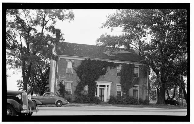
Photo: Historic American Buildings Survey, Library of Congress Prints and Photographs Division, public domain · Wikimedia Commons
Local history sources: en.wikipedia.org · en.wikipedia.org · blog.jimgrey.net · en.wikipedia.org · commons.wikimedia.org · archive.org
Historic places
1 place in Deercreek Township, Madison County on the National Register of Historic Places. Press a pin or a name for its whole record.
-
Red Brick TavernBuilding · Lafayette · listed 1975
- Address
- 1700 Cumberland Rd.
- Where
- Lafayette, Madison County · ZIP 43140
- What it is
- Building
- Listed on the National Register
- 1975
- NRIS reference number
- 75001478
- Coordinates
- 39.93798, -83.40653
National Register file (NPS) ↗ Search Wikipedia ↗ Street map and directions ↗ On the Cracked Buckeye map
Source: National Park Service, National Register of Historic Places point file. The listing year is shown where NPS's certification date agrees with the listing's reference number. Listing recognizes significance; it does not restrict a private owner.
Water
Local glacial sand-and-gravel wells (Madison County) The water here
- Mid-ohio WSD - Chrisman Avenue WTP67% of residentsLocal glacial sand-and-gravel wells (Madison County)
- West Jefferson Village20% of residentsGroundwater wells (4 wells)
- Choctaw Utilities, Inc.11% of residentsGroundwater wells (3 wells)
- Green Meadows Mobile Home Park1% of residentsGroundwater wells (2 wells)
- Jefferson Lodge Mobile Home0% of residentsGroundwater wells (2 wells)
- Picket Fences MHP0% of residentsGroundwater wells (1 wells)
Hospitals, fire stations and more
Inside Deercreek Township, Madison County's boundary: 1 fire or EMS station, 1 poor-rated bridge, 1 public charging site and 11 spill cases. Press a pin or a name for its whole record and its source.
Fire and EMS stations (1)
-
Central Township Fire Department Station 1London
- Address
- 75 Middle Street Southeast, London, OH 43140
- Coordinates
- 39.93674, -83.40495
USGS National Map structures (source) ↗ Street map and directions ↗
Source: USGS National Map structures (most Ohio records last updated 2019 to 2022), checked against the Columbus and Cleveland station lists. The department that answers a call is set by jurisdiction and mutual aid, not by distance.
Bridges rated poor (1)
-
Spring Valley Rd. over Deer Creek TributaryPoor · built 1958
- Condition
- Poor: a deck, superstructure, substructure or culvert rated 4 or below on the 0 to 9 scale
- What it is
- Bridge
- Built
- 1958
- Length
- 9 ft
- Owner
- County
- Vehicles a day
- 1,489
- Coordinates
- 39.90542, -83.39897
National Bridge Inventory (source) ↗ Street map and directions ↗
Source: FHWA National Bridge Inventory 2025. "Poor" means one major part rated 4 or below on the 0 to 9 scale; it calls for repair, not closing, unless the state posts or closes the bridge.
Public EV charging (1)
-
TA, 940 US-42, London, OH DC fast12 DC fast · London
- Address
- 940 US RT 42, London, OH 43140
- Ports
- 12 DC fast
- Plugs
- CCS, Tesla (NACS)
- Network
- BP_PULSE
- Hours
- 24 hours daily
- Phone
- 833-277-8573
Station Locator (NREL) ↗ Alternative Fuels Data Center (source) ↗ Street map and directions ↗
Source: NREL Alternative Fuels Data Center station list (May 2026), public and open stations, the posts at one address counted as one site.
Spills reported since 2021 (11)
-
Fuel Diesel / Diesel Fuel (Vehicle On Or Off Road)2025-08-19 · Deer Creek Twp
- Reported
- 2025-08-19
- What spilled
- Fuel Diesel / Diesel Fuel (Vehicle On Or Off Road)
- Largest amount reported
- 50 gallons
- Where
- Deer Creek Twp, Madison County
- Ohio EPA district office
- SWDO
- Ohio EPA case number
- 2508EPA0001400
Ohio EPA spill reports (source) ↗ Street map and directions ↗
-
Fuel Diesel / Diesel Fuel (Vehicle On Or Off Road)2025-04-04 · Deer Creek Twp
- Reported
- 2025-04-04
- What spilled
- Fuel Diesel / Diesel Fuel (Vehicle On Or Off Road)
- Where
- Deer Creek Twp, Madison County
- Ohio EPA district office
- SWDO
- Ohio EPA case number
- 2504EPA0000497
Ohio EPA spill reports (source) ↗ Street map and directions ↗
-
Fuel Diesel / Diesel Fuel (Vehicle On Or Off Road)2025-04-04 · Null
- Reported
- 2025-04-04
- What spilled
- Fuel Diesel / Diesel Fuel (Vehicle On Or Off Road)
- Largest amount reported
- 40 gallons
- Where
- Null, Madison County
- Ohio EPA district office
- SWDO
- Ohio EPA case number
- 2504EPA0000493
Ohio EPA spill reports (source) ↗ Street map and directions ↗
-
Sheen Rainbow / Hydrocarbon Reached water2025-03-14 · Deer Creek Twp
- Reported
- 2025-03-14
- What spilled
- Sheen Rainbow / Hydrocarbon
- Reached a waterway
- 99 - Unnamed
- Where
- Deer Creek Twp, Madison County
- Ohio EPA district office
- SWDO
- Ohio EPA case number
- 2503EPA0000353
Ohio EPA spill reports (source) ↗ Street map and directions ↗
-
Fuel Gasoline ( 25% Ethanol Not E85)2024-08-15 · Deer Creek Twp
- Reported
- 2024-08-15
- What spilled
- Fuel Gasoline ( 25% Ethanol Not E85)
- Largest amount reported
- 5 gallons
- Where
- Deer Creek Twp, Madison County
- Ohio EPA district office
- SWDO
- Ohio EPA case number
- 2408EPA0001414
Ohio EPA spill reports (source) ↗ Street map and directions ↗
-
Heptane (C7H16)2024-06-16 · Deer Creek Twp
- Reported
- 2024-06-16
- What spilled
- Heptane (C7H16)
- Where
- Deer Creek Twp, Madison County
- Ohio EPA district office
- SWDO
- Ohio EPA case number
- 2406EPA0001013
Ohio EPA spill reports (source) ↗ Street map and directions ↗
-
Fuel Diesel / Diesel Fuel (Vehicle On Or Off Road)2024-05-24 · Deer Creek Twp
- Reported
- 2024-05-24
- What spilled
- Fuel Diesel / Diesel Fuel (Vehicle On Or Off Road)
- Largest amount reported
- 150 gallons
- Where
- Deer Creek Twp, Madison County
- Ohio EPA district office
- SWDO
- Ohio EPA case number
- 2405EPA0000875
Ohio EPA spill reports (source) ↗ Street map and directions ↗
-
Fuel Diesel / Diesel Fuel (Vehicle On Or Off Road)2024-04-18 · Deer Creek Twp
- Reported
- 2024-04-18
- What spilled
- Fuel Diesel / Diesel Fuel (Vehicle On Or Off Road)
- Largest amount reported
- 100 gallons
- Where
- Deer Creek Twp, Madison County
- Ohio EPA district office
- SWDO
- Ohio EPA case number
- 2404EPA0000653
Ohio EPA spill reports (source) ↗ Street map and directions ↗
-
Fuel Diesel / Diesel Fuel (Vehicle On Or Off Road)2022-04-13 · Deer Creek Twp
- Reported
- 2022-04-13
- What spilled
- Fuel Diesel / Diesel Fuel (Vehicle On Or Off Road)
- Largest amount reported
- 200 gallons
- Where
- Deer Creek Twp, Madison County
- Ohio EPA district office
- CDO
- Ohio EPA case number
- 2204EPA0000506
Ohio EPA spill reports (source) ↗ Street map and directions ↗
-
Fuel Diesel / Diesel Fuel (Vehicle On Or Off Road)2021-07-30 · Deer Creek Twp
- Reported
- 2021-07-30
- What spilled
- Fuel Diesel / Diesel Fuel (Vehicle On Or Off Road)
- Largest amount reported
- 100 gallons
- Where
- Deer Creek Twp, Madison County
- Ohio EPA district office
- CDO
- Ohio EPA case number
- 2107EPA0001159
Ohio EPA spill reports (source) ↗ Street map and directions ↗
-
Fuel Diesel / Diesel Fuel (Vehicle On Or Off Road)2026-01-01 · Deer Creek Twp
- Reported
- 2026-01-01
- What spilled
- Fuel Diesel / Diesel Fuel (Vehicle On Or Off Road)
- Largest amount reported
- 100 gallons
- Where
- Deer Creek Twp, Madison County
- Ohio EPA district office
- SWDO
- Ohio EPA case number
- 2601EPA0000002
Ohio EPA spill reports (source) ↗ Street map and directions ↗
Source: Ohio EPA emergency response spill reports, 2021 to September 2026, one point per case where Ohio EPA placed it. A report is what the caller or responder recorded; amounts are often blank or estimated.
Its ZIP codes
Each ZIP code that touches Deercreek Township, Madison County, with the share of its residents who live here and the same headline figures as the ZIP page.
| ZIP | Share | Water | Radon | Home value | Schools | Flood |
|---|---|---|---|---|---|---|
| 43140 London | 3% | Local glacial sand-and-gravel wells (Madison County) | 7.3 pCi/L average radon | Median year built 1974 | London City · 3.5 stars overall | 3.2% of residents in the 1% floodplain |
| 43162 West Jefferson | 3% | Groundwater wells (4 wells) | 7.7 pCi/L average radon | Median year built 1967 | Jefferson Local · 3.5 stars overall | 1.1% of residents in the 1% floodplain |
Local government
How its elections and ballot issues came out.
Elections for office
| Date | Office | Candidates and votes |
|---|---|---|
| 2021-11-02 | Township Trustee | Robert J. Turvy, Jr. 162, 89.5%; Write-In: Charles Raymond Peters III 13, 7.18% |
| 2019-11-05 | Township Trustee | Levin H. Hutson 117, 100.0% |
| 2019-11-05 | Township Fiscal Officer | Erin K. Morris 107, 100.0% |
Winners in bold. Results from the county board of elections' official canvass unless marked. The county's results on file run through 2021-11-02; later elections are not loaded yet.
On the November 3, 2026 ballot
Statewide question: State Issue 3: Voter ID
Races, candidates and every question for an address: your ballot. County offices and judges are on your county board's sample ballot.
The county
Madison County: 6 ZIP codes, 19 cities, villages and townships with pages here, 46,985 people (Census Bureau estimate, July 2025).
Nearby places
Quick answers
What county is Deercreek Township, Ohio in?
Deercreek Township, Madison County is a township in Madison County, Ohio, with 967 residents.
When was Deercreek Township, Ohio founded?
Deercreek Township, Madison County was laid out 1834 (Lafayette; the 1883 county history gives 1837). Founders on record: William Minter, who platted Lafayette on the site of the earlier settlement of Lawrenceville. Source
How did Deercreek Township, Ohio get its name?
The 1883 county history says the name Deer Creek 'originated, it is believed, from the fact that in early days it was the resort of vast herds of deer'. Source
What ZIP code is Deercreek Township, Ohio?
Deercreek Township, Madison County is served by ZIP codes 43140 and 43162; 43140 holds the largest share of its residents.
Where does Deercreek Township, Ohio get its water?
The main water source for Deercreek Township, Madison County (Mid-ohio WSD - Chrisman Avenue WTP): Local glacial sand-and-gravel wells (Madison County).
Cite this page
Cite this page as:
Cracked Buckeye, "Deercreek Township, Madison County", https://crackedbuckeye.com/place/deercreek-township-madison-county/, built 2026-11-02, accessed [date].
How to cite · Report a correction · Built 2026-11-02