Local events in West Jefferson
24 events in the next 90 days from 3 public calendars. All local events in West Jefferson
Checked October 20; the events page is refreshed daily.
Lakes near West Jefferson
The history under the water: the valley before, the dam, the stories. All Ohio lakes
How West Jefferson began
West Jefferson grew out of an older village a mile to its south, New Hampton, platted in 1822 on the Old State Road between Franklinton (Columbus) and Springfield. When the National Road was built just to the north in the 1830s, New Hampton's residents and businesses moved to a new plat, first called Jefferson, that Rev. Isaac Jones surveyed in 1830-31; the village was formally established April 24, 1834, and took a post office in 1833. It sits on U.S. Route 40, the old National Road, in Jefferson Township, and the name became West Jefferson to distinguish it from other Ohio Jeffersons. It remains a small Route 40 village serving the surrounding farmland east of London.
Settled 1822 (as New Hampton, about a mile south of the present site), platted 1830-31 (as Jefferson), incorporated April 24, 1834, by Samuel Jones and Samuel Sexton founded New Hampton in 1822; Rev. Isaac Jones platted the successor town of Jefferson in 1830-31.
Where the name comes from
The village was platted as Jefferson, apparently for President Thomas Jefferson, in the township of the same name. It became West Jefferson to distinguish it from Ohio's other Jefferson place names once a post office and rail traffic made confusion a problem; the predecessor settlement a mile south was called New Hampton, likely for a New England home place of an early settler.
Before the town
No source found records a Native American village, camp, trail, or treaty line specifically at the New Hampton/West Jefferson site or in the immediate area. Ohio History Central and the 1883 county history both discuss Madison County broadly as hunting ground used by Native peoples before removal, with mounds and Indian camping places recorded elsewhere in the county, but neither source ties a specific site to this village's ground. Nothing here should be read as placing a specific village or mound within West Jefferson itself.
Timeline
- — Samuel Jones and Samuel Sexton plat New Hampton on the Old State Road about a mile south of present-day West Jefferson; the village grows to 93 lots on eight streets with a post office, a Baptist church, and several businesses.
- — Rev. Isaac Jones draws the first plat of the new town of Jefferson, just north of New Hampton, on September 13.
- — A post office opens at Jefferson.
- — The village of Jefferson (later West Jefferson) is formally established on April 24; New Hampton, bypassed by the National Road, empties out as residents and buildings move north.
- — New Hampton's Baptist congregation, the settlement's last active institution, reorganizes as a Baptist church in the town of Jefferson.
- — Citizens of Madison County raise $20,000 to help build the Columbus and Xenia Railroad through the area.
- — Ss. Simon and Jude Catholic church is built in West Jefferson.
- — West Jefferson records its first town seal, and West Street is paved with brick.
Stories
A town that moved itself
New Hampton was platted in 1822 on the Old State Road running from Franklinton to Springfield, with 93 lots, eight streets, a Baptist church, a post office, and several stores. It should have been the lasting town in this stretch of Jefferson Township. Instead, when the National Road was pushed through a short distance to the north in the early 1830s, travelers and trade followed the new highway, and New Hampton's own residents began to prefer it. In 1830 Rev. Isaac Jones platted a new town, Jefferson, directly on the National Road; over the next few years New Hampton was taken apart building by building and moved north to the new site, until only its cemetery and a stretch of what had been its Main Street were left behind. The village of West Jefferson is, in effect, New Hampton relocated to catch the road.
Photographs
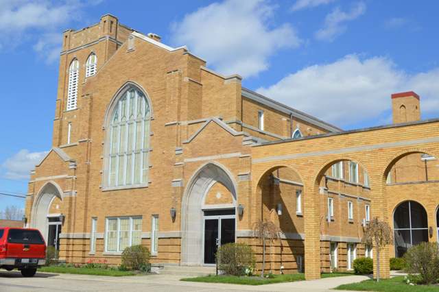
Photo: Nyttend, public domain · Wikimedia Commons
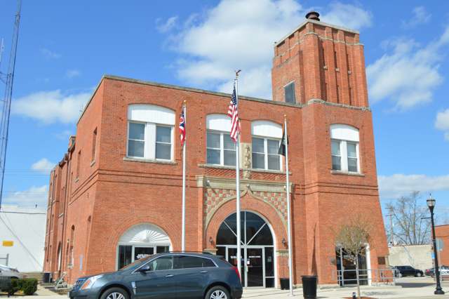
Photo: Nyttend, public domain · Wikimedia Commons
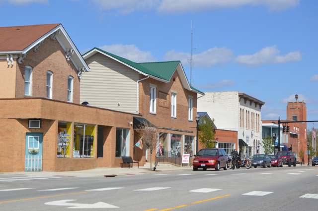
Photo: Nyttend, public domain · Wikimedia Commons
Local history sources: en.wikipedia.org · en.wikipedia.org · en.wikipedia.org · archive.org · ohiohistorycentral.org · commons.wikimedia.org · commons.wikimedia.org · commons.wikimedia.org
Water
Groundwater wells (4 wells) The water here
- West Jefferson Village97% of residentsGroundwater wells (4 wells)
- Jefferson Lodge Mobile Home2% of residentsGroundwater wells (2 wells)
- Picket Fences MHP1% of residentsGroundwater wells (1 wells)
Hospitals, fire stations and more
Inside West Jefferson's boundary: 1 nursing home, 1 fire or EMS station, 1 power plant, 3 public schools, 1 library, 1 police station, 1 public charging site, 4 Toxics Release Inventory facilities and 5 spill cases. Press a pin or a name for its whole record and its source.
Nursing homes (1)
-
Arbors West2 of 5 stars · West Jefferson
- Address
- 375 West Main Street, West Jefferson, OH 43162
- Certified beds
- 94
- Residents on an average day
- 71
- Medicare overall rating
- 2 of 5 stars
- Health inspections
- 2 of 5 stars
- Staffing
- 3 of 5 stars
- Quality measures
- 4 of 5 stars
- Penalties since 2023
- none
- Ownership
- For profit - Corporation
- Chain
- ARBORS AT OHIO
- Takes
- Medicare and Medicaid
- Phone
- (614) 879-7661
- Medicare ID
- 365426
Medicare Care Compare ↗ CMS nursing home data (source) ↗ Street map and directions ↗
Source: CMS Care Compare nursing home provider and penalties files; Medicare star ratings run 1 to 5.
Fire and EMS stations (1)
-
Jefferson Township Fire Department Station 251West Jefferson
- Address
- 745 West Main Street, West Jefferson, OH 43162
- Coordinates
- 39.94335, -83.28796
USGS National Map structures (source) ↗ Street map and directions ↗
Source: USGS National Map structures (most Ohio records last updated 2019 to 2022), checked against the Columbus and Cleveland station lists. The department that answers a call is set by jurisdiction and mutual aid, not by distance.
Power plants (1)
-
IGS CMH4, LLCSolar · 4 MW
- Capacity
- 4 MW
- Main source
- Solar
- Technology
- Solar Photovoltaic
- Operator
- Greenbacker Renewable Energy Corporation
- Sector
- IPP Non-CHP
- Where
- Madison, Madison County
- Generating units
- 1
- Built
- 2023
- EIA plant code
- 66010
EIA plant page ↗ EIA-860 (source) ↗ Street map and directions ↗
Source: EIA-860 power plant inventory via HIFLD (February 2025), with plant codes, units and years from EIA-860 2025.
Public schools (3)
-
Norwood Elementary School3.5 of 5 stars · West Jefferson
- Address
- 899 Norwood Dr, West Jefferson, OH 43162
- School district
- Jefferson Local School District
- Kind (NCES)
- Regular School
- Students, 2023-24
- 429
- Teachers (full-time equivalent)
- 28
- Report card, 2025-26
- 3.5 of 5 stars
- Performance index
- 81.2%
- Ohio building IRN
- 017970
- NCES school ID
- 390482503174
NCES school record ↗ Ohio School Report Card ↗ Street map and directions ↗
-
West Jefferson Middle School3 of 5 stars · West Jefferson
- Address
- 2 Roughrider Drive, West Jefferson, OH 43162
- School district
- Jefferson Local School District
- Kind (NCES)
- Regular School
- Students, 2023-24
- 247
- Teachers (full-time equivalent)
- 15
- Report card, 2025-26
- 3 of 5 stars
- Performance index
- 73.1%
- Ohio building IRN
- 038729
- NCES school ID
- 390482503173
NCES school record ↗ Ohio School Report Card ↗ Street map and directions ↗
-
West Jefferson High School3.5 of 5 stars · West Jefferson
- Address
- 1 Roughrider Dr, West Jefferson, OH 43162
- School district
- Jefferson Local School District
- Kind (NCES)
- Regular School
- Students, 2023-24
- 274
- Teachers (full-time equivalent)
- 21.5
- Report card, 2025-26
- 3.5 of 5 stars
- Performance index
- 73.9%
- Four-year graduation rate
- 98.8%
- Ohio building IRN
- 038737
- NCES school ID
- 390482503176
NCES school record ↗ Ohio School Report Card ↗ Street map and directions ↗
Source: NCES EDGE public school locations 2024-25 and Common Core of Data 2023-24 (type, students, teachers); Ohio School Report Cards 2025-26 (Department of Education and Workforce), matched by name within the district.
Public libraries (1)
-
Hurt/Battelle Memorial LibraryCentral library · West Jefferson
- Address
- 270 Lilly Chapel Rd., West Jefferson, OH 43162
- What it is
- Central library
- Library system
- Hurt/Battelle Memorial Library/West Jefferson
- Open
- 2,444 hours a year, 52 weeks
- Building
- 11,936 sq ft
- System's visits, FY2024
- 18,668
- System's loans, FY2024
- 55,622
- People the system serves
- 7,105
- Phone
- (614) 879-8448
IMLS Public Libraries Survey (source) ↗ Street map and directions ↗
Source: IMLS Public Libraries Survey FY2024 (outlets and their systems). Any Ohio resident can get a free card at any Ohio public library.
Police stations (1)
-
West Jefferson Police DepartmentWest Jefferson
- Address
- 28 East Main Street, West Jefferson, OH 43162
- Coordinates
- 39.94526, -83.26822
USGS National Map structures (source) ↗ Street map and directions ↗
Source: USGS National Map structures, police stations, corrected and completed by hand (September 2026). The department that answers a call is set by jurisdiction, not by distance.
Public EV charging (1)
-
Subway1 Level 2 · West Jefferson
- Address
- 97 E Main St, West Jefferson, OH 43162
- Ports
- 1 Level 2
- Plugs
- J1772
- Network
- Non-Networked
- Hours
- 24 hours daily
- Price
- Free
- Phone
- 614-879-9993
Station Locator (NREL) ↗ Alternative Fuels Data Center (source) ↗ Street map and directions ↗
Source: NREL Alternative Fuels Data Center station list (May 2026), public and open stations, the posts at one address counted as one site.
Facilities reporting toxic releases (4)
-
Conduit Pipe Products CoToxics Release Inventory · West Jefferson
- Address
- 1501 West Main Street, West Jefferson, OH 43162
- County
- Madison County
- Status
- Reports to the Toxics Release Inventory (active)
- EPA program ID
- 43162CPTLM1501W
- EPA registry ID
- 110000382201
EPA facility record ↗ EPA Facility Registry Service (source) ↗ Street map and directions ↗
-
Fisher Cast Steel Products *Toxics Release Inventory · West Jefferson
- Address
- 12 E. Town St., West Jefferson, OH 43162
- County
- Madison County
- Status
- Reports to the Toxics Release Inventory (active)
- EPA program ID
- 43162FSHRC12TOW
- EPA registry ID
- 110000382210
EPA facility record ↗ EPA Facility Registry Service (source) ↗ Street map and directions ↗
-
Jefferson Industries CorpToxics Release Inventory · West Jefferson
- Address
- 6670 State Rt.29 N.E., West Jefferson, OH 43162
- County
- Madison County
- Status
- Reports to the Toxics Release Inventory (open)
- EPA program ID
- 43162JFFRS6670S
- EPA registry ID
- 110000382229
EPA facility record ↗ EPA Facility Registry Service (source) ↗ Street map and directions ↗
-
West Jefferson- MfiToxics Release Inventory · West Jefferson
- Address
- 2 Walker Way, West Jefferson, OH 43162
- County
- Madison County County
- Status
- Reports to the Toxics Release Inventory (***unchanged***)
- EPA program ID
- 4316WWSTJF2WALK
- EPA registry ID
- 110071948257
EPA facility record ↗ EPA Facility Registry Service (source) ↗ Street map and directions ↗
Source: EPA Facility Registry Service, Toxics Release Inventory reporters. Reporting a release is required of large users of listed chemicals; it is not by itself a violation.
Spills reported since 2021 (5)
-
Material Blue2025-10-21 · Jefferson Twp
- Reported
- 2025-10-21
- What spilled
- Material Blue
- Where
- Jefferson Twp, Madison County
- Ohio EPA district office
- SWDO
- Ohio EPA case number
- 2510EPA0001732
Ohio EPA spill reports (source) ↗ Street map and directions ↗
-
Sheen Organic2022-08-28 · West Jefferson
- Reported
- 2022-08-28
- What spilled
- Sheen Organic
- Where
- West Jefferson, Madison County
- Ohio EPA district office
- CDO
- Ohio EPA case number
- 2208EPA0001322
Ohio EPA spill reports (source) ↗ Street map and directions ↗
-
Oil Petroleum Not Otherwise Specified (Nos)2022-07-06 · West Jefferson
- Reported
- 2022-07-06
- What spilled
- Oil Petroleum Not Otherwise Specified (Nos)
- Largest amount reported
- 25 gallons
- Where
- West Jefferson, Madison County
- Ohio EPA district office
- CDO
- Ohio EPA case number
- 2207EPA0001023
Ohio EPA spill reports (source) ↗ Street map and directions ↗
-
Other / All Other / Trade Name / Mixture / Solution Etc2022-01-19 · West Jefferson
- Reported
- 2022-01-19
- What spilled
- Other / All Other / Trade Name / Mixture / Solution Etc
- Where
- West Jefferson, Madison County
- Ohio EPA district office
- CDO
- Ohio EPA case number
- 2201EPA0000057
Ohio EPA spill reports (source) ↗ Street map and directions ↗
-
Fuel Diesel / Diesel Fuel (Vehicle On Or Off Road)2026-05-04 · West Jefferson
- Reported
- 2026-05-04
- What spilled
- Fuel Diesel / Diesel Fuel (Vehicle On Or Off Road)
- Largest amount reported
- 50 gallons
- Where
- West Jefferson, Madison County
- Ohio EPA district office
- SWDO
- Ohio EPA case number
- 2605EPA0000746
Ohio EPA spill reports (source) ↗ Street map and directions ↗
Source: Ohio EPA emergency response spill reports, 2021 to September 2026, one point per case where Ohio EPA placed it. A report is what the caller or responder recorded; amounts are often blank or estimated.
Its ZIP codes
Each ZIP code that touches West Jefferson, with the share of its residents who live here and the same headline figures as the ZIP page.
| ZIP | Share | Water | Radon | Home value | Schools | Flood |
|---|---|---|---|---|---|---|
| 43162 West Jefferson | 60% | Groundwater wells (4 wells) | 7.7 pCi/L average radon | Median year built 1967 | Jefferson Local · 3.5 stars overall | 1.1% of residents in the 1% floodplain |
Local government
Who holds office in West Jefferson, how its elections and ballot issues came out, and the state auditor's record.
Ballot issues
| Date | Issue | For | Against | Result |
|---|---|---|---|---|
| 2021-11-02 | Issue: Village of West Jefferson Charter - 7A.01, 6.03, 7A.02 Development/Redevelopment, Public Service | 468 | 330 | Passed (58.65% for) |
| 2021-11-02 | Issue: Village of West Jefferson Charter - Hiring and Appointment Procedures | 499 | 291 | Passed (63.16% for) |
| 2021-11-02 | Issue: Village of West Jefferson Charter -Removals and Vacancies | 524 | 261 | Passed (66.75% for) |
| 2021-11-02 | Issue: Village of West Jefferson Charter - Remuneration and Regular Meetings | 476 | 307 | Passed (60.79% for) |
Elections for office
| Date | Office | Candidates and votes |
|---|---|---|
| 2021-11-02 | Member of Council, Ward 4 | Howard S. Wade, Jr. 125, 100.0% |
| 2021-11-02 | Member of Council, Ward 3 | Jennifer Warner 141, 100.0% |
| 2021-11-02 | Member of Council, Ward 2 | Linda Hall 187, 100.0% |
| 2021-11-02 | Member of Council, Ward 1 | Samantha Cahill 149, 67.12%; Jim King 73, 32.88% |
| 2019-11-05 | Member of Council, Ward 2 | Linda S. Hall 156, 100.0% |
| 2019-11-05 | Member of Council at Large | Michael W. Conway 321, 25.95%; James D. Graham 224, 18.11%; Richard A. King 372, 30.07%; Jeffery B. Patterson 320, 25.87% |
| 2019-11-05 | Mayor | Ray A. Martin 502, 100.0% |
Winners in bold. Results from the county board of elections' official canvass unless marked.
Auditor of State record
- No fiscal caution, watch or emergency on the Auditor of State's lists.
- OP&F Examination, 2024, released 2026-05-07
- Financial Audit, 2023 to 2024, released 2025-09-02
The county
Madison County: 6 ZIP codes, 19 cities, villages and townships, 38,669 people.
Nearby places
Rain and snow
How much has actually fallen on West Jefferson, day by day, from 1893 to now. Daily totals, not averages.
- rain, last 30 days
- 0.97 in
- 2026-09-30 to 2026-10-29
- rain so far in 2026
- 44.2 in
- 9.6 in above normal for the date
- snow so far in 2026
- 20.7 in
- a normal year brings 15.8 in
- a normal year
- 40.6 in
- average of 30 years, 1991-2020
| Month | Rain (in) | Snow (in) | Days counted |
|---|---|---|---|
| October 2026 | 0.97 | — | 29 |
| September 2026 | 6.39 | — | 30 |
| August 2026 | 8.96 | — | 31 |
| July 2026 | 3.68 | — | 31 |
| June 2026 | 3.24 | — | 30 |
| May 2026 | 7.39 | — | 31 |
| April 2026 | 2.62 | — | 30 |
| March 2026 | 6.71 | 2.3 | 31 |
| February 2026 | 2.50 | 3.3 | 28 |
| January 2026 | 1.78 | 15.0 | 31 |
| December 2025 | 2.16 | 10.0 | 31 |
| November 2025 | 2.62 | 1.9 | 30 |
| Wettest year | 2018 — 57.3 in |
|---|---|
| Driest year | 1930 — 24.8 in |
| Snowiest year | 1926 — 49.3 in |
| Wettest day on record | 14 September 1979 — 4.95 in |
| Heaviest snowfall in a day | 19 March 1906 — 12.01 in |
| Deepest snow on the ground | 12 January 1996 — 24.02 in |
Mostly estimated. Only 1% of these days come from a gauge standing inside West Jefferson - the rest are worked out from the nearest gauges around it, so read them as close estimates rather than readings.
47,953 days of records, 1893-06-01 to 2026-10-29. Source: NOAA NCEI GHCN-Daily, 3,240 gauges in and around Ohio. A day is "gauged" when a gauge standing inside the boundary reported it, and the value is the mean of those gauges. Otherwise it is interpolated by inverse distance from every gauge reporting within 50 miles. Nothing is carried forward, back-filled or smoothed. Against NOAA nClimDiv county monthly precipitation over 136,848 complete county-months (checked 2026-10-31): correlation 0.9515, median absolute difference 0.217 in a month. Built 2026-10-31 from the Cracked Buckeye precipitation archive. Snow is the softer number — snowfall is measured by hand with a ruler, no agency publishes a gridded county snowfall series, and blowing snow defeats every observer.
Environmental permits and filings
What Ohio EPA has on file for West Jefferson: permits, inspections, violations, cleanups and the state loans behind sewer and water work. Every line links to the agency's own document.
- facilities and sites on file
- 84
- those placed on the map inside West Jefferson
Data centers, power and big tech here. Ohio EPA files that name a data-center company, a power plant or substation, or a large technology firm:
- AMAZON.COM SERVICES LLC - CMH4 (hazardous waste, latest Dec 18, 2023)
- NATIONAL MOD SUBSTATION TAP (wastewater and stormwater discharge, latest May 18, 2023)
| Program | Facilities and sites |
|---|---|
| Wastewater and stormwater discharge | 43 |
| Hazardous waste | 9 |
| Sewer and water-line construction | 7 |
| Wetland and stream fill | 7 |
| Air pollution | 5 |
| Public drinking water | 4 |
| Contaminated-site cleanup | 3 |
| Chemical accident plans | 1 |
| Composting | 1 |
| Federal Facilities | 1 |
| Site assessment | 1 |
| State sewer loans | 1 |
| 1 smaller programs |
| Date | Facility or site | What |
|---|---|---|
| BATTELLE MEMORIAL INSTITUTE | Wastewater and stormwater discharge permit | |
| COLUMBUS LOGISTICS PARK WEST BUILDING II | Wastewater and stormwater discharge permit | |
| BATTELLE MEMORIAL INSTITUTE | Wastewater and stormwater discharge permit | |
| MADISON COUNTY SEWER DISTRICT 1 | Wastewater and stormwater discharge report | |
| CVP US 40 PROJECT | Wetland and stream fill permit | |
| BATTELLE MEMORIAL INSTITUTE | Wastewater and stormwater discharge permit | |
| JEFFERSON LODGE MOBILE HOME PWS | Public drinking water notice of violation | |
| CVP US 40 PROJECT | Wetland and stream fill permit | |
| CIRCLE K WEST JEFFERSON | Wastewater and stormwater discharge permit | |
| AMAZONCOM SERVICES LLC - OOH9 | Wastewater and stormwater discharge permit | |
| AMAZONCOM SERVICES LLC - OOH9 | Wastewater and stormwater discharge permit | |
| WEST JEFFERSON COMPOSTING FACILITY | Composting inspection | |
| DARBY PLACE | Wetland and stream fill permit | |
| FISHER CAST STEEL PRODUCTS INC | Air pollution report | |
| JEFFERSON LODGE MOBILE HOME PWS | Public drinking water report | |
| LITTLE DARBY CREEK WETLAND | Wastewater and stormwater discharge inspection | |
| WEST JEFFERSON VILLAGE PWS | Public drinking water compliance letter | |
| WEST JEFFERSON VILLAGE PWS | Public drinking water compliance letter | |
| WEST JEFFERSON VILLAGE PWS | Public drinking water compliance letter | |
| DARBY PLACE | Wetland and stream fill permit | |
| WEST JEFFERSON VILLAGE PWS | Public drinking water compliance letter | |
| MADISON COUNTY SEWER DISTRICT 1 | Wastewater and stormwater discharge report | |
| BATTELLE MEMORIAL INSTITUTE | Wastewater and stormwater discharge inspection | |
| WEST JEFFERSON MEADOWS | Wastewater and stormwater discharge permit | |
| WEST JEFFERSON VILLAGE PWS | Public drinking water plan |
Source: Ohio EPA eDocument portal (edocpub.epa.ohio.gov), indexed 2026-10-14. Facilities are placed on the map from Ohio EPA's own map layers, EPA's Facility Registry, coordinates written in the filings, or a geocoded street address. A permit filed under a private person's name (most are household septic systems) is counted but never named, placed or linked; licenses for individual workers and open-burning notices are left out entirely.
Quick answers
What county is West Jefferson, Ohio in?
West Jefferson is a village in Madison County, Ohio, with 4,171 residents.
When was West Jefferson, Ohio founded?
West Jefferson was settled 1822 (as New Hampton, about a mile south of the present site); laid out 1830-31 (as Jefferson); incorporated April 24, 1834. Founders on record: Samuel Jones and Samuel Sexton founded New Hampton in 1822; Rev. Isaac Jones platted the successor town of Jefferson in 1830-31. Source
How did West Jefferson, Ohio get its name?
The village was platted as Jefferson, apparently for President Thomas Jefferson, in the township of the same name. Source
What ZIP code is West Jefferson, Ohio?
Most of West Jefferson is in ZIP code 43162.
Where does West Jefferson, Ohio get its water?
The main water source for West Jefferson (West Jefferson Village): Groundwater wells (4 wells).
Cite this page
Cite this page as:
Cracked Buckeye, "West Jefferson, Madison County", https://crackedbuckeye.com/place/west-jefferson/, built 2026-10-31, accessed [date].
How to cite · Report a correction · Built 2026-10-31
