Local events in Chippewa Lake
Chippewa Lake itself has 3 events posted in the next 90 days; the others here are within 10 miles. All local events in Chippewa Lake
Checked October 20; the events page is refreshed daily.
Deep dives about Chippewa Lake
Long reads built from maps, newspapers and public records. All deep dives
How Chippewa Lake began
Chippewa Lake village grew up on the shore of Ohio's largest natural inland lake, itself carved by glaciers around 14,000 years ago and named for the Ojibwe (Chippewa) nation of the western Great Lakes. Native people used the lake's fertile wetlands and shoreline for hunting and fishing long before Euro-American settlement began around the time of the War of 1812. In the 1880s, developer Oscar Townsend and the Cleveland, Lorain & Wheeling Railroad built a lakeside resort that grew into Chippewa Lake Park, an amusement park that drew Clevelanders by passenger train for nearly a century before closing in 1978; the village itself incorporated in 1920. The Medina County Park District now manages the lake for public fishing and boating.
Settled c. 1812 (first settlers arrive around the War of 1812 era), incorporated 1920, by lakeside settlement later developed as a resort by Oscar Townsend and the Cleveland, Lorain & Wheeling Railroad.
Where the name comes from
The village and lake take their name from the Ojibwe (Chippewa) nation of the western Great Lakes region (Michigan, Wisconsin, Minnesota, North Dakota and Ontario), though no source located ties any specific historic Ojibwe village, camp or band to this particular lake; the name appears to be a settler-era application of a well-known Native nation's name to a striking natural landmark rather than a record of that nation's own presence here.
Before the town
Chippewa Lake -- Ohio's largest natural inland lake, covering roughly 355 acres with an additional 200 acres of swamp forest and wetland at its north and south ends -- was carved by the retreating Wisconsin Age glacier roughly 12,500 years ago, and its fertile shoreline and wetlands drew Native people to hunt, fish and gather for thousands of years before Euro-American settlement, according to local historical accounts; no source we found, however, names a specific Native nation, village, camp or burial site at the lake itself, and the 'Chippewa' name is better documented as a settler-era naming choice (see name_origin) than as a record of Ojibwe presence specifically at this lake, as distinct from the wider region. The lake is unusual hydrologically as the only natural body of water in the country that drains into both the Great Lakes and Ohio River basins, which may have made it a notable landmark to travelers of any era. The county-level history file carries the fuller treaty context: the 1805 Treaty of Fort Industry, signed by the Wyandot, Ottawa, Chippewa, Munsee/Delaware, Shawnee and Potawatomi nations among others, opened all of Medina County, including the Chippewa Lake area, to settlement.
Nations recorded here: Chippewa (Ojibwe) -- name origin only; no site-specific presence confirmed.
Timeline
- — The retreating Wisconsin Age glacier carves out Chippewa Lake, leaving behind Ohio's largest natural inland lake.
- — The first Euro-American settlers arrive at Chippewa Lake, around the time of the War of 1812.
- — Developer Oscar Townsend and the Cleveland, Lorain & Wheeling Railroad establish a lakeside vacation resort on Chippewa Lake's shore, the beginning of what becomes Chippewa Lake Park.
- — The village of Chippewa Lake incorporates.
- — A picnic pavilion and pier are built at Chippewa Lake Park.
- — Chippewa Lake Park, by then a century-old amusement destination, closes permanently.
- — Scenes for the horror film Closed for the Season are shot at the abandoned Chippewa Lake Park.
Stories
A Century of Summer Trains to the Lake
In the 1880s, developer Oscar Townsend saw commercial potential in Medina County's largest natural lake and partnered with the Cleveland, Lorain & Wheeling Railroad to build a resort on its shore. What began as a simple lakeside retreat for Clevelanders escaping the summer heat grew, over the following decades, into Chippewa Lake Park -- a full amusement park with rides, a grand ballroom, water activities and a picnic pavilion and pier built in 1927, all reachable by passenger train. Cottage communities sprang up around the lake alongside it, including Gloria Glens, Briarwood Beach and Chippewa-on-the-Lake, and before mechanical refrigeration became common, residents harvested and sold ice cut from the lake in winter. The park drew crowds for nearly a century, hosting entertainers and dignitaries, before finally closing for good in 1978; its abandoned grounds later drew a different kind of visitor, including a film crew who shot scenes for the horror movie Closed for the Season there in 2008. Today the Medina County Park District manages the lake itself for public fishing and boating, a quieter fate than the one it knew in its amusement-park heyday.
Photographs
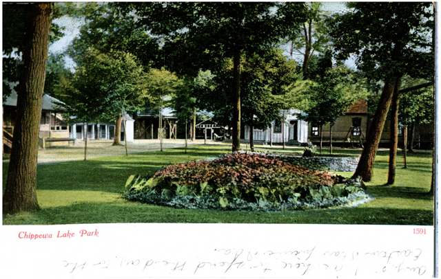
Photo: Columbus Metropolitan Library, via Digital Public Library of America, no known copyright restrictions · Wikimedia Commons
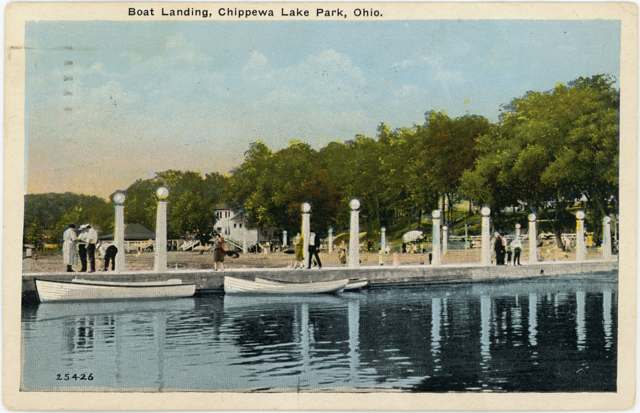
Photo: Columbus Metropolitan Library, via Digital Public Library of America, no known copyright restrictions · Wikimedia Commons
Local history sources: en.wikipedia.org · clohs.org · medinaco.org · commons.wikimedia.org
Water
Groundwater wells (3 wells) The water here
- Medina Co/southern Water Dist83% of residentsGroundwater wells (3 wells)
- Medina Co/northwest17% of residentsLake Erie
Hospitals, fire stations and more
Inside Chippewa Lake's boundary: 1 poor-rated bridge. Press a pin or a name for its whole record and its source.
Bridges rated poor (1)
-
Rd 50 - Chippewa over Mccabe CreekPoor · built 1990
- Condition
- Poor: a deck, superstructure, substructure or culvert rated 4 or below on the 0 to 9 scale
- What it is
- Culvert
- Built
- 1990
- Length
- 8 ft
- Owner
- County
- Vehicles a day
- 904
- Coordinates
- 41.07676, -81.90476
National Bridge Inventory (source) ↗ Street map and directions ↗
Source: FHWA National Bridge Inventory 2025. "Poor" means one major part rated 4 or below on the 0 to 9 scale; it calls for repair, not closing, unless the state posts or closes the bridge.
Its ZIP codes
Each ZIP code that touches Chippewa Lake, with the share of its residents who live here and the same headline figures as the ZIP page.
| ZIP | Share | Water | Radon | Home value | Schools | Flood |
|---|---|---|---|---|---|---|
| 44215 Lafayette Township and Chippewa Lake | 26% | Groundwater wells (3 wells) | 3.5 pCi/L average radon | Median year built 1959 | Cloverleaf Local · 4 stars overall | 3.4% of residents in the 1% floodplain |
Local government
Who holds office in Chippewa Lake, how its elections and ballot issues came out, and the state auditor's record.
Money issues on the ballot since 2019: 2 of 2 passed.
Ballot issues
| Date | Issue | For | Against | Result |
|---|---|---|---|---|
| 2022-11-08 | 15: 15 Proposed Tax Levy Village of Chippewa Lake | 180 | 118 | Passed (60.4% for), unofficial |
| 2019-11-05 | 21: 21 Proposed Tax Levy Chippewa Lake Village | 92 | 60 | Passed (60.53% for) |
Elections for office
| Date | Office | Candidates and votes |
|---|---|---|
| 2025-11-04 | Member of Council (unofficial count) | Allan R. Horning 122, 30.96%; Barb Hunter 139, 35.28%; Tamitha Sorgi 133, 33.76% |
| 2025-11-04 | Mayor (unofficial count) | Joanne Dodaro 153, 100.0% |
| 2023-11-07 | Member of Council (unofficial count) | Leslie D. Burns 191, 52.19%; Ken Demeter 175, 47.81% |
| 2021-11-02 | Member of Council (unofficial count) | Lowell Hardesty 109, 21.67%; Barb Hunter 136, 27.04%; Alan Robbins 130, 25.84%; Tamitha Sorgi 128, 25.45% |
| 2021-11-02 | Mayor (unofficial count) | Joanne Dodaro 150, 100.0% |
| 2019-11-05 | Member of Council | Keith Riedel 137, 79.19%; Write-In: Ken Demeter 22, 12.72% |
| 2017-11-07 | Mayor | Joanne Dodaro 146, 100.0% |
| 2017-11-07 | Council | Sarah Arend 102, 29.74%; Barbie Hunter 128, 37.32%; Alan E. Robbins 113, 32.94% |
Winners in bold. Results from the county board of elections' official canvass unless marked.
Auditor of State record
- No fiscal caution, watch or emergency on the Auditor of State's lists.
- Financial Audit, 2022 to 2023, released 2025-07-01
The county
Medina County: 13 ZIP codes, 26 cities, villages and townships, 180,994 people.
Nearby places
Rain and snow
How much has actually fallen on Chippewa Lake, day by day, from 1893 to now. Daily totals, not averages.
- rain, last 30 days
- 2.00 in
- 2026-09-29 to 2026-10-28
- rain so far in 2026
- 36.7 in
- 1.9 in above normal for the date
- snow so far in 2026
- 32.7 in
- a normal year brings 39.2 in
- a normal year
- 41.0 in
- average of 30 years, 1991-2020
| Month | Rain (in) | Snow (in) | Days counted |
|---|---|---|---|
| October 2026 | 2.00 | — | 28 |
| September 2026 | 4.77 | — | 30 |
| August 2026 | 4.31 | — | 31 |
| July 2026 | 3.07 | — | 31 |
| June 2026 | 3.42 | — | 30 |
| May 2026 | 5.01 | — | 31 |
| April 2026 | 7.22 | 0.1 | 30 |
| March 2026 | 4.08 | 0.9 | 31 |
| February 2026 | 0.86 | 10.1 | 28 |
| January 2026 | 1.95 | 21.6 | 31 |
| December 2025 | 2.38 | 11.8 | 31 |
| November 2025 | 1.63 | 3.6 | 30 |
| Wettest year | 2011 — 62.7 in |
|---|---|
| Driest year | 1963 — 21.4 in |
| Snowiest year | 1910 — 80.8 in |
| Wettest day on record | 5 July 1969 — 4.42 in |
| Heaviest snowfall in a day | 9 November 1913 — 21.61 in |
| Deepest snow on the ground | 27 December 1995 — 23.59 in |
Estimated, not measured. No rain gauge has ever stood inside Chippewa Lake, so every figure here is worked out from the gauges around it - the nearest ones weighted most. Treat them as close estimates rather than readings.
48,721 days of records, 1893-01-01 to 2026-10-28. Source: NOAA NCEI GHCN-Daily, 3,240 gauges in and around Ohio. A day is "gauged" when a gauge standing inside the boundary reported it, and the value is the mean of those gauges. Otherwise it is interpolated by inverse distance from every gauge reporting within 50 miles. Nothing is carried forward, back-filled or smoothed. Against NOAA nClimDiv county monthly precipitation over 136,848 complete county-months (checked 2026-10-31): correlation 0.9515, median absolute difference 0.217 in a month. Built 2026-10-31 from the Cracked Buckeye precipitation archive. Snow is the softer number — snowfall is measured by hand with a ruler, no agency publishes a gridded county snowfall series, and blowing snow defeats every observer.
Quick answers
What county is Chippewa Lake, Ohio in?
Chippewa Lake is a village in Medina County, Ohio, with 602 residents.
When was Chippewa Lake, Ohio founded?
Chippewa Lake was settled c. 1812 (first settlers arrive around the War of 1812 era); incorporated 1920. Founders on record: lakeside settlement later developed as a resort by Oscar Townsend and the Cleveland, Lorain & Wheeling Railroad. Source
How did Chippewa Lake, Ohio get its name?
The village and lake take their name from the Ojibwe (Chippewa) nation of the western Great Lakes region (Michigan, Wisconsin, Minnesota, North Dakota and Ontario), though no source located ties any specific historic Ojibwe village, camp or band to this particular lake; the name appears to be a settler-era application of a well-known Native nation's name to a striking natural landmark rather than a record of that nation's own presence here. Source
What ZIP code is Chippewa Lake, Ohio?
Most of Chippewa Lake is in ZIP code 44215.
Where does Chippewa Lake, Ohio get its water?
The main water source for Chippewa Lake (Medina Co/southern Water Dist): Groundwater wells (3 wells).
Cite this page
Cite this page as:
Cracked Buckeye, "Chippewa Lake, Medina County", https://crackedbuckeye.com/place/chippewa-lake/, built 2026-10-31, accessed [date].
How to cite · Report a correction · Built 2026-10-31
