Local events in Canaan Township, Madison County
4 events in the next 90 days from 2 public calendars. All local events in Canaan Township, Madison County
Checked October 20; the events page is refreshed daily.
How Canaan Township, Madison County began
Canaan Township, in the northeastern corner of Madison County along the Big and Little Darby creeks, was organized in 1819 under the name Phelps before quickly being renamed Canaan. It holds a distinct place in the county's history: Jonathan Alder, captured by Shawnee as a boy in 1782 and raised by a Mingo family, settled here on the Big Darby after the 1795 Treaty of Greenville and is usually called the first white settler in Madison County; he lived out his life and died here in 1849. Settlement otherwise followed the Darby and Deer creeks from about 1800, with the mill village of Amity growing up around the Beach brothers' saw- and carding-mills. It remains a farming township with no incorporated village of its own.
Settled 1796 (Jonathan Alder) / c. 1800 (organized settlement), incorporated 1819, first as 'Phelps' Township, renamed Canaan soon after, by township organizers unnamed in sources; Amity village founded by Uri Beach and Lorenzo Beach.
Where the name comes from
The township was first organized in 1819 under the name 'Phelps' and renamed Canaan shortly afterward; no source found explains why either name was chosen, though Canaan is a common Biblical place-name reused across many Ohio townships (it is also the name of townships in Athens, Morrow, and Wayne counties).
Before the town
Canaan Township carries an unusually specific piece of Native American history. In 1796, settler Benjamin Springer found Jonathan Alder — a white man captured by a Shawnee raiding party in Virginia in 1782 at age eight, and adopted afterward by a Mingo chief named Succohanos and his wife Whinecheoh near a Mingo village north of the Mad River in present-day Logan County — living with his Native wife Barshaw (from Upper Sandusky) on the west bank of Big Darby Creek, inside what became Canaan Township. Sources describe the Darby and Deer Creek valleys as favorite hunting grounds of Native people before white settlement, with settlers finding encampments there, though no specific village name, mound, or trail within the township is recorded beyond Alder's cabin site. Alder had spent about 13 years among the Mingo, fought under the Shawnee war leader Blue Jacket in the Northwest Indian War (including the 1794 attack on Fort Recovery), and remained on the Darby after the August 1795 Treaty of Greenville ended the war and opened the region to white settlement. He separated from Barshaw, later reunited with his Virginia family, remarried, and lived the rest of his life in the township, dying there in 1849; his cabin is preserved at the Madison County Historical Society Museum in London. Beyond the Alder episode, no county-level survey of Adena, Hopewell, or Fort Ancient sites specific to Canaan Township was found.
Nations recorded here: Shawnee, Mingo (Seneca-Cayuga).
- Jonathan Alder cabin site / west bank of Big Darby Creek (other) — Canaan Township, on Big Darby Creek, 1796 (found by Springer) through Alder's death in 1849 (en.wikipedia.org)
Timeline
- — Eight-year-old Jonathan Alder is captured by a Shawnee raiding party near present-day Virginia; his brother David is killed. He is later adopted by Mingo chief Succohanos and his wife Whinecheoh near a village north of the Mad River.
- — The Treaty of Greenville ends the Northwest Indian War, in which Alder had fought under Shawnee leader Blue Jacket; the treaty opens the region to white settlement.
- — Settler Benjamin Springer finds Jonathan Alder living with his Native wife Barshaw on the west bank of Big Darby Creek — the first known white presence in what became Canaan Township and Madison County.
- — Luther Cary, a New Jersey native, settles on the Big Darby north of the future village of Amity; he lives in the township until his death in 1834.
- — Brothers Jonathan and Joel Harris, also from New Jersey, settle within the township.
- — Alder marries Mary Ann Blont in Virginia and returns with her to a second cabin he builds on Big Darby Creek; they have twelve children between 1808 and 1830.
- — Thomas Kilgore, a Pennsylvania native, settles in the township and goes on to serve more than 60 years in township offices.
- — The township is organized, first under the name 'Phelps,' then quickly renamed Canaan.
- — Uri Beach establishes a saw-mill and carding-mill on land purchased from Doctor Comstock, giving rise to the village of Amity; his brother Dr. Lorenzo Beach becomes the township's first physician around the same time.
- — Jonathan Alder dies in Canaan Township, Madison County, at age 75.
- — Township population recorded at 685.
Stories
The captive who came home to the Darby
Jonathan Alder was eight years old in 1782 when a Shawnee raiding party killed his brother David and carried him off from the Virginia frontier. Because his dark hair let him pass for Native, his life was spared, and a Mingo chief named Succohanos and his wife Whinecheoh adopted him in place of a son they had lost. Alder grew up Mingo: he hunted, ran the gauntlet as a rite of passage, and at nineteen or twenty fought under the Shawnee war leader Blue Jacket against American forces, including the 1794 attack on Fort Recovery. When the 1795 Treaty of Greenville ended the fighting, Alder was a grown man with a Native wife, Barshaw, and no memory of most of his birth family. He settled with her on the Big Darby, where settler Benjamin Springer found the couple in 1796 — the first white presence recorded in what became Canaan Township. The marriage did not last; the couple separated, believing, as Alder later told it, that 'the Great Spirit was opposed to their marriage,' and he left Barshaw the cabin, the cows, seven horses, and roughly two hundred dollars in silver. Alder placed advertisements that reached his one surviving brother in Virginia, traveled there in 1805, remarried there, to Mary Ann Blont, a woman from Virginia, in 1806, and returned to Big Darby Creek to build a second cabin and raise twelve children. He served as a militia captain during the War of 1812, helping build the only fort ever constructed in what became Union County, and died in Canaan Township in 1849 at 75, a man who had lived a full life on both sides of the frontier line.
A mill makes a village
Amity did not begin as a town but as a mill. Around 1820, Uri Beach bought land from a Doctor Comstock and put up a saw-mill and a carding-mill for processing wool — the kind of practical machinery every frontier neighborhood needed and few had. Farmers who once hauled logs and fleece long distances could now bring them to Beach's mills on the Darby, and a settlement grew up around the work the way many small Ohio villages did. Uri's brother, Dr. Lorenzo Beach, arrived around the same time and became the township's first physician, rounding out a settlement that could now saw its own lumber, card its own wool, and treat its own sick.
Photographs
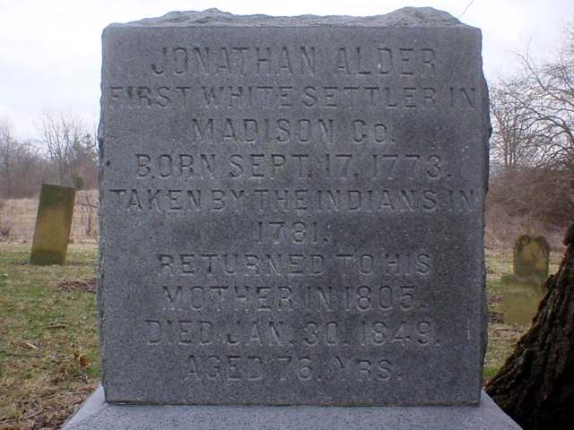
Photo: Adolphus79 (Wikipedia user), public domain · Wikimedia Commons
Local history sources: en.wikipedia.org · remarkableohio.org · heritagepursuit.com · en.wikipedia.org · en.wikipedia.org · commons.wikimedia.org · commons.wikimedia.org · en.wikipedia.org · en.wikipedia.org
Water
Mill Creek water pumped into and stored in the Marysville Upground Reservoir on Raymond Road, plus groundwater from city-owned wells, treated at the plant on the reservoir site The water here
- Marysville City50% of residentsMill Creek via Marysville Reservoir (Raymond Rd) + wells
- Mid-ohio WSD - Jackson Street WTP36% of residentsGroundwater wells (2 wells)
- Columbus Public Water System8% of residentsScioto River (Griggs & O'Shaughnessy), Hoover Reservoir on Big Walnut Ck, plus wells
- Canaan Community MHP2% of residentsGroundwater wells (2 wells)
- Del-co Water Company, Inc.2% of residentsOlentangy River, O'Shaughnessy and Alum Creek reservoirs, plus Knox County wells
- Suburbans Community MHP1% of residentsGroundwater wells (2 wells)
Hospitals, fire stations and more
Inside Canaan Township, Madison County's boundary: 4 public schools, 2 poor-rated bridges, 1 public charging site and 6 spill cases. Press a pin or a name for its whole record and its source.
Public schools (4)
-
Canaan Middle School4.5 of 5 stars · Plain
- Address
- 7055 US Highway 42 S, Plain, OH 43064
- School district
- Jonathan Alder Local School District
- Kind (NCES)
- Regular School
- Students, 2023-24
- 352
- Teachers (full-time equivalent)
- 18.56
- Report card, 2025-26
- 4.5 of 5 stars
- Performance index
- 85.9%
- Ohio building IRN
- 000883
- NCES school ID
- 390482605138
NCES school record ↗ Ohio School Report Card ↗ Street map and directions ↗
-
Jonathan Alder High School4 of 5 stars · Plain City
- Address
- 9200 US Route 42 S, Plain City, OH 43064
- School district
- Jonathan Alder Local School District
- Kind (NCES)
- Regular School
- Students, 2023-24
- 671
- Teachers (full-time equivalent)
- 34.57
- Report card, 2025-26
- 4 of 5 stars
- Performance index
- 87.6%
- Four-year graduation rate
- 98.7%
- Ohio building IRN
- 018507
- NCES school ID
- 390482603178
NCES school record ↗ Ohio School Report Card ↗ Street map and directions ↗
-
Jonathan Alder Junior High4.5 of 5 stars · Plain City
- Address
- 6440 Kilbury Huber Rd, Plain City, OH 43064
- School district
- Jonathan Alder Local School District
- Kind (NCES)
- Regular School
- Students, 2023-24
- 346
- Teachers (full-time equivalent)
- 19.67
- Report card, 2025-26
- 4.5 of 5 stars
- Performance index
- 87.8%
- Ohio building IRN
- 004747
- NCES school ID
- 390482603177
NCES school record ↗ Ohio School Report Card ↗ Street map and directions ↗
-
Tolles Career & Technical CenterPlain City
- Address
- 7877 US Highway 42 S, Plain City, OH 43064
- Kind (NCES)
- Career and Technical School
- Students, 2023-24
- 380
- Teachers (full-time equivalent)
- 59.25
- NCES school ID
- 390635104124
Source: NCES EDGE public school locations 2024-25 and Common Core of Data 2023-24 (type, students, teachers); Ohio School Report Cards 2025-26 (Department of Education and Workforce), matched by name within the district.
Bridges rated poor (2)
-
County Rd 7 over Three Mile RunPoor · built 1920
- Condition
- Poor: a deck, superstructure, substructure or culvert rated 4 or below on the 0 to 9 scale
- What it is
- Bridge
- Built
- 1920
- Length
- 8 ft
- Owner
- County
- Vehicles a day
- 3,334
- Coordinates
- 40.01785, -83.26193
National Bridge Inventory (source) ↗ Street map and directions ↗
-
Scioto Darby Cr.rd over Big Darby (scioto Darby)Poor · built 1986
- Condition
- Poor: a deck, superstructure, substructure or culvert rated 4 or below on the 0 to 9 scale
- What it is
- Bridge
- Built
- 1986
- Length
- 86 ft
- Owner
- County
- Vehicles a day
- 11,541
- Coordinates
- 40.04059, -83.25245
National Bridge Inventory (source) ↗ Street map and directions ↗
Source: FHWA National Bridge Inventory 2025. "Poor" means one major part rated 4 or below on the 0 to 9 scale; it calls for repair, not closing, unless the state posts or closes the bridge.
Public EV charging (1)
-
TOLLES TOLLES EAST4 Level 2 · Plain City
- Address
- 7877 US-42, Plain City, OH 43064
- Ports
- 4 Level 2
- Plugs
- J1772
- Network
- ChargePoint Network
- Hours
- 24 hours daily
- Phone
- 888-758-4389
Station Locator (NREL) ↗ Alternative Fuels Data Center (source) ↗ Street map and directions ↗
Source: NREL Alternative Fuels Data Center station list (May 2026), public and open stations, the posts at one address counted as one site.
Spills reported since 2021 (6)
-
Sewage Human Reached water2025-12-30 · Canaan Twp
- Reported
- 2025-12-30
- What spilled
- Sewage Human
- Reached a waterway
- 49 - Big Darby Creek
- Where
- Canaan Twp, Madison County
- Ohio EPA district office
- SWDO
- Ohio EPA case number
- 2512EPA0002072
Ohio EPA spill reports (source) ↗ Street map and directions ↗
-
Oil Transformer Non Pcb2025-05-30 · Canaan Twp
- Reported
- 2025-05-30
- What spilled
- Oil Transformer Non Pcb
- Largest amount reported
- 45 gallons
- Where
- Canaan Twp, Madison County
- Ohio EPA district office
- SWDO
- Ohio EPA case number
- 2505EPA0000876
Ohio EPA spill reports (source) ↗ Street map and directions ↗
-
Sewage Human Reached water2024-09-03 · Canaan Twp
- Reported
- 2024-09-03
- What spilled
- Sewage Human
- Largest amount reported
- 200 gallons
- Reached a waterway
- 49 - Fitzgerald Ditch
- Where
- Canaan Twp, Madison County
- Ohio EPA district office
- SWDO
- Ohio EPA case number
- 2409EPA0001512
Ohio EPA spill reports (source) ↗ Street map and directions ↗
-
Fuel Diesel / Diesel Fuel (Vehicle On Or Off Road)2023-04-08 · Canaan Twp
- Reported
- 2023-04-08
- What spilled
- Fuel Diesel / Diesel Fuel (Vehicle On Or Off Road)
- Largest amount reported
- 300 gallons
- Where
- Canaan Twp, Madison County
- Ohio EPA district office
- CDO
- Ohio EPA case number
- 2304EPA0000538
Ohio EPA spill reports (source) ↗ Street map and directions ↗
-
Oil Crude Reached water2022-07-02 · Canaan Twp
- Reported
- 2022-07-02
- What spilled
- Oil Crude
- Reached a waterway
- 99 - Unnamed
- Where
- Canaan Twp, Madison County
- Ohio EPA district office
- CDO
- Ohio EPA case number
- 2207EPA0001003
Ohio EPA spill reports (source) ↗ Street map and directions ↗
-
Sewage Sludge / Biosolids2026-01-04 · Canaan Twp
- Reported
- 2026-01-04
- What spilled
- Sewage Sludge / Biosolids
- Where
- Canaan Twp, Madison County
- Ohio EPA district office
- SWDO
- Ohio EPA case number
- 2601EPA0000009
Ohio EPA spill reports (source) ↗ Street map and directions ↗
Source: Ohio EPA emergency response spill reports, 2021 to September 2026, one point per case where Ohio EPA placed it. A report is what the caller or responder recorded; amounts are often blank or estimated.
Its ZIP codes
Each ZIP code that touches Canaan Township, Madison County, with the share of its residents who live here and the same headline figures as the ZIP page.
| ZIP | Share | Water | Radon | Home value | Schools | Flood |
|---|---|---|---|---|---|---|
| 43064 Jerome Township and Plain City | 15% | Mill Creek water pumped into and stored in the Marysville Upground Reservoir on Raymond Road, plus groundwater from city-owned wells, treated at the plant on the reservoir site | 5.7 pCi/L average radon | Median year built 2014 | Jonathan Alder Local · 4.5 stars overall | 1.9% of residents in the 1% floodplain |
The county
Union County: 8 ZIP codes, 20 cities, villages and townships, 62,790 people.
Nearby places
Quick answers
What county is Canaan Township, Ohio in?
Canaan Township, Madison County is a township in Union County, Ohio, with 2,631 residents.
When was Canaan Township, Ohio founded?
Canaan Township, Madison County was settled 1796 (Jonathan Alder) / c. 1800 (organized settlement); incorporated 1819, first as 'Phelps' Township, renamed Canaan soon after. Founders on record: township organizers unnamed in sources; Amity village founded by Uri Beach and Lorenzo Beach. Source
How did Canaan Township, Ohio get its name?
The township was first organized in 1819 under the name 'Phelps' and renamed Canaan shortly afterward; no source found explains why either name was chosen, though Canaan is a common Biblical place-name reused across many Ohio townships (it is also the name of townships in Athens, Morrow, and Wayne counties). Source
What ZIP code is Canaan Township, Ohio?
Most of Canaan Township, Madison County is in ZIP code 43064.
Where does Canaan Township, Ohio get its water?
The main water source for Canaan Township, Madison County (Marysville City): Mill Creek water pumped into and stored in the Marysville Upground Reservoir on Raymond Road, plus groundwater from city-owned wells, treated at the plant on the reservoir site.
Cite this page
Cite this page as:
Cracked Buckeye, "Canaan Township, Madison County", https://crackedbuckeye.com/place/canaan-township-madison-county/, built 2026-10-31, accessed [date].
How to cite · Report a correction · Built 2026-10-31
