Local events in Belpre
Belpre itself has 2 events posted in the next 90 days; the others here are within 20 miles. All local events in Belpre
Checked October 20; the events page is refreshed daily.
Lakes near Belpre
The history under the water: the valley before, the dam, the stories. All Ohio lakes
How Belpre began
Belpre was settled in 1788-1789 by a second wave of Ohio Company of Associates pioneers who moved downriver from Marietta to the fertile bottomland opposite the mouth of the Little Kanawha River. Its name comes from 'Belle Prairie,' French for 'beautiful meadow,' a name French traders had already given the valley. When the Northwest Indian War broke out, settlers built Farmer's Castle, a large defensive blockhouse, in January 1791, the same winter as the Big Bottom massacre upriver. Across the Ohio River, Blennerhassett Island became notorious in 1805-1806 as the staging ground for Aaron Burr's alleged conspiracy. Belpre grew as a river town and, after 1870, a rail junction once the Baltimore and Ohio Railroad's Parkersburg Bridge -- then the longest in the world -- connected it to West Virginia; the 2020 census recorded 6,728 residents.
Settled 1788-1789, by Ohio Company of Associates settlers moving downriver from Marietta.
Where the name comes from
From 'Belle Prairie,' French for 'beautiful meadow,' a name French trappers had given the valley before American settlement.
Before the town
No village, trail or mound site specific to the city of Belpre itself was found in the sources checked. The settlement's own founding is bound up with the region's Native conflict: when the Northwest Indian War broke out after the January 1791 Big Bottom massacre upriver (in what is now Morgan County), Belpre's settlers built a fortified blockhouse called Farmer's Castle to protect the community, a structure that stood through the war until the 1795 Treaty of Greenville brought peace. Downstream, Blennerhassett Island -- visible from Belpre across the Ohio River -- had earlier been the home of Nemacolin, a Lenape (Delaware) leader, who is recorded as having died there in 1767, before the island passed to European ownership.
Nations recorded here: Lenape (Delaware).
- Farmer's Castle (other) — Belpre riverfront, Washington County, built January 1791, through the Northwest Indian War to 1795 (commons.wikimedia.org)
Timeline
- — Ohio Company of Associates pioneers move downriver from Marietta and settle the Belle Prairie bottomland opposite the Little Kanawha River.
- — In January, following the Big Bottom massacre and the outbreak of the Northwest Indian War, Belpre settlers build the Farmer's Castle blockhouse for defense.
- — Harman and Margaret Blennerhassett acquire the eastern part of the island opposite Belpre in the Ohio River, later known as Blennerhassett Island.
- — Aaron Burr and Harman Blennerhassett are alleged to have plotted the Burr Conspiracy at the Blennerhassett House on the island across from Belpre.
- — The Blennerhassett House on the island burns down.
- — The Charles Rice Ames House, later called the region's finest Greek Revival house, is built in Belpre.
- — The Baltimore and Ohio Railroad completes the Parkersburg Bridge, at 7,140 feet then the longest bridge in the world, linking Belpre to Parkersburg, West Virginia and opening the area to coal shipping.
- — The Charles Rice Ames House is listed on the National Register of Historic Places.
Stories
A castle of logs against a war it did not start
Belpre's settlers had only been on the ground two or three years when, in January 1791, a war party struck the new Ohio Company settlement at Big Bottom upriver, killing fourteen people and opening four years of frontier warfare across the Ohio country. With no fort of their own, Belpre's families pooled their labor that same winter to raise Farmer's Castle, a large fortified blockhouse on the riverbank strong enough to shelter the whole community. The structure held through the Northwest Indian War until General Anthony Wayne's victory at Fallen Timbers and the 1795 Treaty of Greenville finally brought peace to the region, after which Belpre's farms and river trade could grow without the constant threat that had shaped its first years.
The island across the river
From Belpre's riverbank, settlers could see the wooded island where Harman Blennerhassett, an Irish aristocrat, and his wife Margaret built an elegant mansion beginning in 1798. It became, briefly, one of the most talked-about addresses on the frontier: in 1805 and 1806, former Vice President Aaron Burr is alleged to have used the island as a staging point for a conspiracy to carve out an independent territory in the West, a plan that collapsed when Burr was arrested and tried for treason. The Blennerhassett mansion burned in 1811 and was never rebuilt, but the episode left Belpre permanently tied, in the region's memory, to one of the strangest political intrigues of the early republic -- one that played out in plain sight of the Ohio farm town across the water.
Photographs
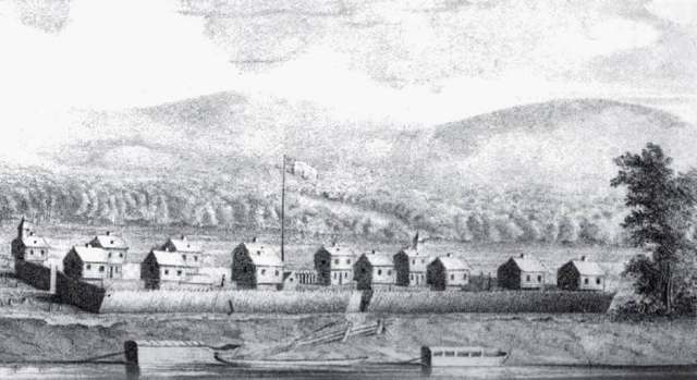
Photo: S. P. Hildreth, 'Pioneer History' (1848), public domain · Wikimedia Commons
Local history sources: en.wikipedia.org · en.wikipedia.org · en.wikipedia.org · en.wikipedia.org · en.wikipedia.org · commons.wikimedia.org · en.wikipedia.org
Historic places
3 places in Belpre on the National Register of Historic Places. Press a pin or a name for its whole record.
-
Ames, Charles Rice, HouseBuilding · Belpre · listed 1978
- Address
- 2212 Miller Ave.
- Where
- Belpre, Washington County · ZIP 45714
- What it is
- Building
- Listed on the National Register
- 1978
- NRIS reference number
- 78002208
- Coordinates
- 39.28309, -81.60577
National Register file (NPS) ↗ Search Wikipedia ↗ Street map and directions ↗ On the Cracked Buckeye map
-
Spencer's LandingBuilding · Belpre · listed 1992
- Address
- 4 E. Fifth St.
- Where
- Belpre, Washington County · ZIP 45714
- What it is
- Building
- Listed on the National Register
- 1992
- NRIS reference number
- 92001035
- Coordinates
- 39.27689, -81.56653
National Register file (NPS) ↗ Search Wikipedia ↗ Street map and directions ↗ On the Cracked Buckeye map
-
Stone, Capt. Jonathan, HouseBuilding · Belpre · listed 1978
- Address
- 612 Blennerhassett Ave.
- Where
- Belpre, Washington County · ZIP 45714
- What it is
- Building
- Listed on the National Register
- 1978
- NRIS reference number
- 78002209
- Coordinates
- 39.27107, -81.57680
National Register file (NPS) ↗ Search Wikipedia ↗ Street map and directions ↗ On the Cracked Buckeye map
Source: National Park Service, National Register of Historic Places point file. The listing year is shown where NPS's certification date agrees with the listing's reference number. Listing recognizes significance; it does not restrict a private owner.
Water
Groundwater wells (5 wells) The water here
- Belpre City81% of residentsGroundwater wells (5 wells)
- Little Hocking Water Association, Inc.19% of residentsOhio River Valley Aquifer (own wells, Porterfield wellfield)
Hospitals, fire stations and more
Inside Belpre's boundary: 1 health center, 2 nursing homes, 2 fire and EMS stations, 3 public schools, 1 poor-rated bridge, 1 library, 1 police station, 1 public charging site, 1 Superfund site, 3 Toxics Release Inventory facilities and 5 spill cases. Press a pin or a name for its whole record and its source.
Community health centers (1)
-
Hopewell Health Centers - BelpreHealth center · Belpre
- Run by
- a federally qualified health center
- Setting
- Clinic
- City
- Belpre
- Coordinates
- 39.28547, -81.60963
Find a Health Center (HRSA) ↗ HRSA data (source) ↗ Street map and directions ↗
Source: HRSA health center service delivery sites, active, September 2026 (school-based sites left out). Health centers see patients whether or not they have insurance, with fees on a sliding scale.
Nursing homes (2)
-
Belpre Landing Nursing and Rehabilitation2 of 5 stars · Belpre
- Address
- 1915 Hill Street, Belpre, OH 45714
- Certified beds
- 62
- Residents on an average day
- 49
- Medicare overall rating
- 2 of 5 stars
- Health inspections
- 2 of 5 stars
- Staffing
- 2 of 5 stars
- Quality measures
- 4 of 5 stars
- Penalties since 2023
- none
- Ownership
- For profit - Corporation
- Chain
- CONTINUING HEALTHCARE SOLUTIONS
- Takes
- Medicare and Medicaid
- Phone
- (740) 350-9095
- Medicare ID
- 366443
Medicare Care Compare ↗ CMS nursing home data (source) ↗ Street map and directions ↗
-
Rockland Ridge Nursing & Rehabilitation Center5 of 5 stars · Belpre
- Address
- 2511 Washington Blvd, Belpre, OH 45714
- Certified beds
- 70
- Residents on an average day
- 64
- Medicare overall rating
- 5 of 5 stars
- Health inspections
- 4 of 5 stars
- Staffing
- 4 of 5 stars
- Quality measures
- 5 of 5 stars
- Penalties since 2023
- none
- Ownership
- For profit - Corporation
- Chain
- FOUNDATIONS HEALTH SOLUTIONS
- Takes
- Medicare and Medicaid
- Phone
- (740) 780-6005
- Medicare ID
- 366486
Medicare Care Compare ↗ CMS nursing home data (source) ↗ Street map and directions ↗
Source: CMS Care Compare nursing home provider and penalties files; Medicare star ratings run 1 to 5.
Fire and EMS stations (2)
-
Belpre Volunteer Fire Department Station 1Belpre
- Address
- 704 Washington Boulevard, Belpre, OH 45714
- Coordinates
- 39.27354, -81.57799
USGS National Map structures (source) ↗ Street map and directions ↗
-
Belpre Volunteer Fire Department Station 2Belpre
- Address
- 721 Farson Street, Belpre, OH 45714
- Coordinates
- 39.28122, -81.61138
USGS National Map structures (source) ↗ Street map and directions ↗
Source: USGS National Map structures (most Ohio records last updated 2019 to 2022), checked against the Columbus and Cleveland station lists. The department that answers a call is set by jurisdiction and mutual aid, not by distance.
Public schools (3)
-
Belpre Blue Sky Academy2.5 of 5 stars · Belpre
- Address
- 2014 Rockland Ave, Belpre, OH 45714
- School district
- Belpre City School District
- Kind (NCES)
- Regular School
- Students, 2023-24
- 14
- Report card, 2025-26
- 2.5 of 5 stars
- Performance index
- 43.7%
- Ohio building IRN
- 019798
- NCES school ID
- 390436106193
NCES school record ↗ Ohio School Report Card ↗ Street map and directions ↗
-
Belpre Elementary School4 of 5 stars · Belpre
- Address
- 2000 Rockland Ave, Belpre, OH 45714
- School district
- Belpre City School District
- Kind (NCES)
- Regular School
- Students, 2023-24
- 509
- Teachers (full-time equivalent)
- 28
- Report card, 2025-26
- 4 of 5 stars
- Performance index
- 75.4%
- Ohio building IRN
- 142240
- NCES school ID
- 390436104194
NCES school record ↗ Ohio School Report Card ↗ Street map and directions ↗
-
Belpre High School3 of 5 stars · Belpre
- Address
- 300 Stone Rd, Belpre, OH 45714
- School district
- Belpre City School District
- Kind (NCES)
- Regular School
- Students, 2023-24
- 374
- Teachers (full-time equivalent)
- 32
- Report card, 2025-26
- 3 of 5 stars
- Performance index
- 72.2%
- Four-year graduation rate
- 89%
- Ohio building IRN
- 002337
- NCES school ID
- 390436100159
NCES school record ↗ Ohio School Report Card ↗ Street map and directions ↗
Source: NCES EDGE public school locations 2024-25 and Common Core of Data 2023-24 (type, students, teachers); Ohio School Report Cards 2025-26 (Department of Education and Workforce), matched by name within the district.
Bridges rated poor (1)
-
Mr-476 Memorial To over Ohio R. Csx Keever St.Poor · built 1955
- Condition
- Poor: a deck, superstructure, substructure or culvert rated 4 or below on the 0 to 9 scale
- What it is
- Bridge
- Built
- 1955
- Length
- 779 ft
- Owner
- State
- Vehicles a day
- 11,215
- Coordinates
- 39.28352, -81.56698
National Bridge Inventory (source) ↗ Street map and directions ↗
Source: FHWA National Bridge Inventory 2025. "Poor" means one major part rated 4 or below on the 0 to 9 scale; it calls for repair, not closing, unless the state posts or closes the bridge.
Public libraries (1)
-
Belpre Branch LibraryBranch · Belpre
- Address
- 2012 Washington Blvd., Belpre, OH 45714
- What it is
- Branch
- Library system
- Washington County Public Library
- Open
- 2,288 hours a year, 52 weeks
- Building
- 5,326 sq ft
- System's visits, FY2024
- 113,464
- System's loans, FY2024
- 555,089
- People the system serves
- 59,711
- Phone
- (740) 423-8381
IMLS Public Libraries Survey (source) ↗ Street map and directions ↗
Source: IMLS Public Libraries Survey FY2024 (outlets and their systems). Any Ohio resident can get a free card at any Ohio public library.
Police stations (1)
-
Belpre Police DepartmentBelpre
- Address
- 715 Park Drive, Belpre, OH 45714
- Coordinates
- 39.27769, -81.59420
USGS National Map structures (source) ↗ Street map and directions ↗
Source: USGS National Map structures, police stations, corrected and completed by hand (September 2026). The department that answers a call is set by jurisdiction, not by distance.
Public EV charging (1)
-
Civitan Park2 Level 2 · Belpre
- Address
- Civitan Park, Belpre, OH 45714
- Ports
- 2 Level 2
- Plugs
- J1772
- Network
- Non-Networked
- Hours
- 24 hours daily
- Price
- Free
- Phone
- 740-423-7592
Station Locator (NREL) ↗ Alternative Fuels Data Center (source) ↗ Street map and directions ↗
Source: NREL Alternative Fuels Data Center station list (May 2026), public and open stations, the posts at one address counted as one site.
Superfund sites (1)
-
Shell Chemical Company Marietta PlantSuperfund program · Belpre
- Address
- 2982 Washington Blvd, Belpre, OH 45714
- County
- Washington County
- Status
- Superfund program site, not on the National Priorities List
- EPA program ID
- OHD004343117
- EPA registry ID
- 110071101853
EPA facility record ↗ EPA Facility Registry Service (source) ↗ Street map and directions ↗
Source: EPA Facility Registry Service, Superfund (SEMS) and National Priorities List sites. Many program sites were assessed and needed no cleanup.
Facilities reporting toxic releases (3)
-
Nova Chemicals IncToxics Release Inventory · Belpre
- Address
- Township Rd. 97, Belpre, OH 45714
- County
- Washington County
- Status
- Reports to the Toxics Release Inventory (active)
- EPA program ID
- 45714HNTSMTOWNS
- EPA registry ID
- 110000591912
EPA facility record ↗ EPA Facility Registry Service (source) ↗ Street map and directions ↗
-
Raiser Aluminum & Chemical, CorporationToxics Release Inventory · Belpre
- Address
- Farson Street, Belpre, OH 45714
- County
- Washington County
- Status
- Reports to the Toxics Release Inventory (active)
- EPA program ID
- 45714KSRLMFARSO
- EPA registry ID
- 110007769986
EPA facility record ↗ EPA Facility Registry Service (source) ↗ Street map and directions ↗
-
Toll Compaction Group LlcToxics Release Inventory · Belpre
- Address
- 721 Farson Street, Belpre, OH 45714
- County
- Washington County
- Status
- Reports to the Toxics Release Inventory (active)
- EPA program ID
- 45714NTRNT721FA
- EPA registry ID
- 110008598286
EPA facility record ↗ EPA Facility Registry Service (source) ↗ Street map and directions ↗
Source: EPA Facility Registry Service, Toxics Release Inventory reporters. Reporting a release is required of large users of listed chemicals; it is not by itself a violation.
Spills reported since 2021 (5)
-
Chemical(S) Unk2025-07-07 · Belpre
- Reported
- 2025-07-07
- What spilled
- Chemical(S) Unk; Acid Nos (Not Specified)
- Where
- Belpre, Washington County
- Ohio EPA district office
- SEDO
- Ohio EPA case number
- 2507EPA0001122
Ohio EPA spill reports (source) ↗ Street map and directions ↗
-
Asphalt / Bitumen2024-06-12 · Belpre
- Reported
- 2024-06-12
- What spilled
- Asphalt / Bitumen
- Largest amount reported
- 1,000 gallons
- Where
- Belpre, Washington County
- Ohio EPA district office
- SEDO
- Ohio EPA case number
- 2406EPA0000988
Ohio EPA spill reports (source) ↗ Street map and directions ↗
-
Oil Motor / Lube Oil / Vehicle2024-05-03 · Belpre
- Reported
- 2024-05-03
- What spilled
- Oil Motor / Lube Oil / Vehicle
- Where
- Belpre, Washington County
- Ohio EPA district office
- SEDO
- Ohio EPA case number
- 2405EPA0000735
Ohio EPA spill reports (source) ↗ Street map and directions ↗
-
Cyclohexane (C6H12)2024-03-13 · Belpre
- Reported
- 2024-03-13
- What spilled
- Cyclohexane (C6H12)
- Where
- Belpre, Washington County
- Ohio EPA district office
- SEDO
- Ohio EPA case number
- 2403EPA0000400
Ohio EPA spill reports (source) ↗ Street map and directions ↗
-
Oil Motor / Lube Oil / Vehicle2021-02-18 · Belpre
- Reported
- 2021-02-18
- What spilled
- Oil Motor / Lube Oil / Vehicle
- Where
- Belpre, Washington County
- Ohio EPA district office
- SEDO
- Ohio EPA case number
- 2102EPA0000217
Ohio EPA spill reports (source) ↗ Street map and directions ↗
Source: Ohio EPA emergency response spill reports, 2021 to September 2026, one point per case where Ohio EPA placed it. A report is what the caller or responder recorded; amounts are often blank or estimated.
Its ZIP codes
Each ZIP code that touches Belpre, with the share of its residents who live here and the same headline figures as the ZIP page.
| ZIP | Share | Water | Radon | Home value | Schools | Flood |
|---|---|---|---|---|---|---|
| 45714 Belpre | 65% | Groundwater wells (5 wells) | 3.4 pCi/L average radon | Median year built 1967 | Belpre City · 3.5 stars overall | 12% of residents in the 1% floodplain |
Local government
Who holds office in Belpre, how its elections and ballot issues came out, and the state auditor's record.
Elections for office
| Date | Office | Candidates and votes |
|---|---|---|
| 2023-11-07 | Third Ward Council Member | Lyndsay Dennis (REP) 469, 100.0% |
| 2023-11-07 | Second Ward Council Member | Write-In: Erica Campbell 26, 38.24%; Write-In: Richard Seebaugh 42, 61.76% |
| 2023-11-07 | Member of Council at Large | David E. Ferguson (REP) 1,075, 27.31%; Nathaniel S. Godfrey (REP) 1,057, 26.85%; Michael L. Lorentz (DEM) 835, 21.21%; Penne L. Riffle (REP) 969, 24.62% |
| 2023-11-07 | Member of Board of Education | Larry Lorentz 1,401, 37.09%; Frank Meredith IV 1,022, 27.06%; Cathy O'Donnell 1,354, 35.85% |
| 2023-11-07 | Mayor | Romel Henderson (DEM) 384, 18.85%; Alan Millhone 188, 9.23%; James E. Nelson 519, 25.48%; Susan J. Abdella (REP) 946, 46.44% |
| 2023-11-07 | Fourth Ward Council Member | John J. Ambrozy (REP) 451, 100.0% |
| 2023-11-07 | First Ward Council Member | William W. Locke (REP) 343, 100.0% |
| 2023-11-07 | Director of Law | Thomas P. Webster (DEM) 1,396, 100.0% |
| 2023-05-02 | Member of Council, Third Ward (REP primary) | Lyndsay Dennis 238, 100.0% |
| 2023-05-02 | Member of Council, Fourth Ward (REP primary) | John J. Ambrozy 201, 67.0%; Steve Null 99, 33.0% |
| 2023-05-02 | Member of Council, First Ward (REP primary) | William W. Locke 189, 100.0% |
| 2023-05-02 | Member of Council At-Large (REP primary) | David E. Ferguson 686, 37.55%; Nathaniel S. Godfrey 586, 32.07%; Penne L. Riffle 555, 30.38% |
| 2023-05-02 | Mayor (REP primary) | Susan J. Abdella 804, 100.0% |
| 2021-05-04 | Member of Council At Large (REP primary) (unofficial count) | David E. Ferguson 331, 56.1%; John W. Ruth 259, 43.9% |
| 2019-11-05 | Treasurer | Write-In: Linda Copeland 52, 100.0% |
| 2019-11-05 | Third Ward Council Member | Timothy Gant (REP) 244, 100.0% |
| 2019-11-05 | Second Ward Council Member | Elmer Lee Shutts (REP) 167, 100.0% |
| 2019-11-05 | Member of Council at Large | David E. Ferguson (REP) 839, 31.58%; Larry K. Martin (REP) 660, 24.84%; Donna L. Miller (REP) 704, 26.5%; Paul A. Wallace 454, 17.09% |
| 2019-11-05 | Member of Board of Education | Brenda Church 969, 51.41%; Cathy O'Donnell 916, 48.59% |
| 2019-11-05 | Member of Board of Education | Michael L. Miller 1,087, 100.0% |
| 2019-11-05 | Mayor | Judy Drake (REP) 405, 31.86%; Romel Henderson 210, 16.52%; Michael L. Lorentz (DEM) 656, 51.61% |
| 2019-11-05 | Fourth Ward Council Member | Penne L. Riffle (REP) 305, 100.0% |
| 2019-11-05 | First Ward Council Member | Joshua I. Campbell (REP) 159, 100.0% |
| 2019-11-05 | Director of Law | Thomas P. Webster (DEM) 923, 100.0% |
Winners in bold. Results from the county board of elections' official canvass unless marked.
Auditor of State record
- No fiscal caution, watch or emergency on the Auditor of State's lists.
- Financial Health Indicators (the Auditor of State's 17 measures; critical / cautionary / positive): 2020 1 / 1 / 15; 2021 1 / 1 / 15; 2022 1 / 0 / 16; 2023 1 / 1 / 15; 2024 1 / 1 / 15; 2025 1 / 1 / 14.
- Financial Audit, 2024, released 2026-01-27
- OP&F Examination, 2023, released 2025-05-08
- Financial Audit, 2023, released 2025-02-13
The county
Washington County: 17 ZIP codes, 33 cities, villages and townships, 61,140 people.
Nearby places
Rain and snow
How much has actually fallen on Belpre, day by day, from 1893 to now. Daily totals, not averages.
- rain, last 30 days
- 2.68 in
- 2026-09-29 to 2026-10-28
- rain so far in 2026
- 46.8 in
- 9.0 in above normal for the date
- snow so far in 2026
- 12.8 in
- a normal year brings 13.7 in
- a normal year
- 44.5 in
- average of 30 years, 1991-2020
| Month | Rain (in) | Snow (in) | Days counted |
|---|---|---|---|
| October 2026 | 2.68 | — | 28 |
| September 2026 | 7.84 | — | 30 |
| August 2026 | 9.31 | — | 31 |
| July 2026 | 4.67 | — | 31 |
| June 2026 | 4.95 | — | 30 |
| May 2026 | 6.56 | — | 31 |
| April 2026 | 2.87 | — | 30 |
| March 2026 | 4.94 | 3.1 | 31 |
| February 2026 | 0.88 | 3.0 | 28 |
| January 2026 | 2.13 | 6.7 | 31 |
| December 2025 | 1.79 | 6.6 | 31 |
| November 2025 | 2.66 | 1.5 | 30 |
| Wettest year | 2011 — 61.7 in |
|---|---|
| Driest year | 1930 — 20.3 in |
| Snowiest year | 1910 — 46.8 in |
| Wettest day on record | 28 June 1998 — 4.08 in |
| Heaviest snowfall in a day | 18 January 1994 — 16.56 in |
| Deepest snow on the ground | 27 November 1950 — 26.50 in |
Mostly estimated. Only 1% of these days come from a gauge standing inside Belpre - the rest are worked out from the nearest gauges around it, so read them as close estimates rather than readings.
48,839 days of records, 1893-01-01 to 2026-10-28. Source: NOAA NCEI GHCN-Daily, 3,240 gauges in and around Ohio. A day is "gauged" when a gauge standing inside the boundary reported it, and the value is the mean of those gauges. Otherwise it is interpolated by inverse distance from every gauge reporting within 50 miles. Nothing is carried forward, back-filled or smoothed. Against NOAA nClimDiv county monthly precipitation over 136,848 complete county-months (checked 2026-10-31): correlation 0.9515, median absolute difference 0.217 in a month. Built 2026-10-31 from the Cracked Buckeye precipitation archive. Snow is the softer number — snowfall is measured by hand with a ruler, no agency publishes a gridded county snowfall series, and blowing snow defeats every observer.
Environmental permits and filings
What Ohio EPA has on file for Belpre: permits, inspections, violations, cleanups and the state loans behind sewer and water work. Every line links to the agency's own document.
- facilities and sites on file
- 34
- those placed on the map inside Belpre
| Program | Facilities and sites |
|---|---|
| Hazardous waste | 21 |
| State water loans | 3 |
| Air pollution | 2 |
| Wastewater and stormwater discharge | 2 |
| Brownfield | 1 |
| Cessation Of Regulated Operations | 1 |
| Contaminated-site cleanup | 1 |
| Public drinking water | 1 |
| Source-water protection | 1 |
| Voluntary cleanup | 1 |
| Date | Facility or site | What |
|---|---|---|
| BELPRE CITY PWS | Public drinking water report | |
| BELPRE CITY PWS | Source-water protection report | |
| BELPRE CITY PWS | Public drinking water report | |
| BELPRE CITY PWS | Public drinking water report | |
| BELPRE CITY PWS | Public drinking water compliance letter | |
| BELPRE CITY PWS | Public drinking water report | |
| BELPRE CITY PWS | Public drinking water violation resolved | |
| BELPRE CITY PWS | Public drinking water report | |
| BELPRE CITY PWS | Public drinking water report | |
| BELPRE CITY PWS | Public drinking water report | |
| BELPRE CITY PWS | Public drinking water plan | |
| BELPRE CITY PWS | Public drinking water inspection | |
| BELPRE CITY PWS | Public drinking water report | |
| BELPRE CITY PWS | Public drinking water report | |
| BELPRE CITY PWS | Public drinking water inspection | |
| SPEEDWAY 9743 | Wastewater and stormwater discharge permit | |
| SPEEDWAY 9743 | Wastewater and stormwater discharge permit | |
| BELPRE CITY PWS | Public drinking water report | |
| BELPRE CITY PWS | Public drinking water warning letter | |
| BELPRE CITY PWS | Public drinking water report | |
| MARIETTA MEMORIAL W&C HOSPITAL | Wastewater and stormwater discharge permit | |
| MARIETTA MEMORIAL W&C HOSPITAL | Wastewater and stormwater discharge permit | |
| MARIETTA MEMORIAL W&C HOSPITAL | Wastewater and stormwater discharge permit | |
| MARIETTA MEMORIAL W&C HOSPITAL | Wastewater and stormwater discharge permit | |
| BELPRE CITY PWS | Public drinking water report |
Source: Ohio EPA eDocument portal (edocpub.epa.ohio.gov), indexed 2026-10-14. Facilities are placed on the map from Ohio EPA's own map layers, EPA's Facility Registry, coordinates written in the filings, or a geocoded street address. A permit filed under a private person's name (most are household septic systems) is counted but never named, placed or linked; licenses for individual workers and open-burning notices are left out entirely.
Quick answers
What county is Belpre, Ohio in?
Belpre is a city in Washington County, Ohio, with 6,636 residents.
When was Belpre, Ohio founded?
Belpre was settled 1788-1789. Founders on record: Ohio Company of Associates settlers moving downriver from Marietta. Source
How did Belpre, Ohio get its name?
From 'Belle Prairie,' French for 'beautiful meadow,' a name French trappers had given the valley before American settlement. Source
What ZIP code is Belpre, Ohio?
Most of Belpre is in ZIP code 45714.
Where does Belpre, Ohio get its water?
The main water source for Belpre (Belpre City): Groundwater wells (5 wells).
Cite this page
Cite this page as:
Cracked Buckeye, "Belpre, Washington County", https://crackedbuckeye.com/place/belpre/, built 2026-10-31, accessed [date].
How to cite · Report a correction · Built 2026-10-31
