Wellsville
Village · Columbiana County · 3,113 residents · 1.5% municipal income tax
Local events in Wellsville
4 events in the next 90 days from 1 public calendar. All local events in Wellsville
Checked October 20; the events page is refreshed daily.
How Wellsville began
Wellsville was first settled in 1795 by William Wells and James Clark, who abandoned the site after Native attacks before Wells returned permanently to farm it in 1797 and platted the village in 1820. It grew into a river and rail shipping point with its own pottery and steamboat-machinery industries, hosted a young Abraham Lincoln at a whistle-stop in 1861 and the surrender of Confederate raider John Hunt Morgan's men nearby in 1863, and endured Ohio River flooding severe enough to prompt a permanent flood wall in 1936. Wellsville's population peaked near 8,850 in 1920 before a long decline to roughly 3,100 today; its most improbable modern claim to fame is Wellsville High School's Bevo Francis, who scored 776 points in 25 games as a senior in 1951 before going on to break national college basketball scoring records at Rio Grande College.
Settled 1795 (returned permanently 1797), platted 1820 (by October 1823), by William Wells and James Clark.
Where the name comes from
Named for founder William Wells, a Pennsylvania native and Steubenville judge who laid out the village in 1820 and completed its plat by October 1823.
Before the town
Wellsville sits at the mouth of Yellow Creek, the site of the Mingo leader Logan's hunting camp and village documented from 1773; the Yellow Creek massacre of April 30, 1774, in which Virginia militia killed members of Logan's family across the Ohio River, is one of Columbiana County's most consequential Native American events. Wikipedia's history of Wellsville also records that founder William Wells and James Clark abandoned their first 1795 settlement attempt because of Native attacks, not returning permanently until 1797 -- a detail suggesting continued Native presence or resistance in the immediate area in the mid-1790s, after the 1795 Treaty of Greenville but before the frontier had fully quieted. Local county histories also place the traditional 1782 fight between frontiersman Adam Poe and a Wyandot warrior remembered as Big Foot near the mouth of Little Yellow Creek, about a mile below Wellsville, though accounts of that tradition disagree on its location and date.
Nations recorded here: Mingo (Seneca-Cayuga), Wyandot.
- Logan's Mingo village and camp, mouth of Yellow Creek (village) — Mouth of Yellow Creek, near Wellsville, Occupied by 1773; family members killed in the April 30, 1774 Yellow Creek massacre (en.wikipedia.org)
Timeline
- — George Washington surveys the area on a journey down the Ohio River.
- — The Yellow Creek massacre, involving the Mingo leader Logan's family, occurs near the mouth of Yellow Creek adjacent to the future village.
- — Local tradition places the Adam Poe-Big Foot fight near the mouth of Little Yellow Creek, about a mile below Wellsville.
- — William Wells and James Clark first settle the site, then abandon it after Native attacks.
- — William Wells returns permanently to farm the site.
- — Wells lays out the village of Wellsville, platted fully by October 1823.
- — A foundry producing steamboat machinery opens, later becoming the Stevenson Company, a maker of brick-making equipment.
- — President-elect Abraham Lincoln stops and addresses crowds in Wellsville.
- — Confederate raider John Hunt Morgan's men surrender nearby after Morgan's Raid, and Morgan himself is captured at nearby Salineville.
- — William Jennings Bryan campaigns through Wellsville on a whistle-stop train.
- — Wellsville's population peaks at 8,849.
- — Severe Ohio River flooding prompts construction of a permanent flood wall.
- — Wellsville High School senior Bevo Francis scores 776 points in 25 games, averaging nearly 32 points a game.
Stories
The point guard from a river town who broke college basketball
Bevo Francis was born in nearby Hammondsville in 1932 and transferred to Wellsville High School in 1949 when his father took a job in the school district. As a senior in 1951 he scored 776 points across 25 games, an average approaching 32 a game, carrying Wellsville to a 19-1 regular season -- eye-catching enough that tiny Rio Grande College recruited him despite its enrollment of under a hundred students. There, from 1952 to 1954, Francis put up numbers that still look invented: a 48.3 points-per-game average in 1953, an NCAA record, followed by 48.0 in 1954, including a 113-point single game that stood as the college scoring record until 2012. He never played in the NBA, but the Bevo Francis Award, given today to the nation's top small-college scorer, still carries the name of the kid who first put up video-game numbers in a gym in a Columbiana County river town.
Photographs
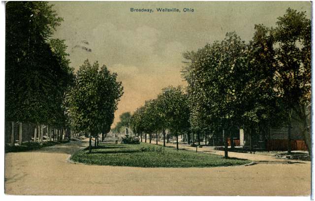
Photo: Columbus Metropolitan Library, via Digital Public Library of America / Ohio Digital Network, public domain · Wikimedia Commons
Local history sources: en.wikipedia.org · en.wikipedia.org · en.wikipedia.org · genealogytrails.com · commons.wikimedia.org
Historic places
1 place in Wellsville on the National Register of Historic Places. Press a pin or a name for its whole record.
-
Episcopal Church of the Ascension and ManseBuilding · Wellsville · listed 1986
- Address
- 1101 and 1109 Eleventh St.
- Where
- Wellsville, Columbiana County · ZIP 43968
- What it is
- Building
- Listed on the National Register
- 1986
- NRIS reference number
- 86001061
- Coordinates
- 40.60221, -80.65065
National Register file (NPS) ↗ Search Wikipedia ↗ Street map and directions ↗ On the Cracked Buckeye map
Source: National Park Service, National Register of Historic Places point file. The listing year is shown where NPS's certification date agrees with the listing's reference number. Listing recognizes significance; it does not restrict a private owner.
Water
No water-system data is linked to Wellsville's ZIP codes yet.
Hospitals, fire stations and more
Inside Wellsville's boundary: 1 fire or EMS station, 3 public schools, 1 library, 1 police station, 4 Toxics Release Inventory facilities and 2 spill cases. Press a pin or a name for its whole record and its source.
Fire and EMS stations (1)
-
Wellsville Fire DepartmentWellsville
- Address
- 1202 Main Street, Wellsville, OH 43968
- Coordinates
- 40.60072, -80.65195
USGS National Map structures (source) ↗ Street map and directions ↗
Source: USGS National Map structures (most Ohio records last updated 2019 to 2022), checked against the Columbus and Cleveland station lists. The department that answers a call is set by jurisdiction and mutual aid, not by distance.
Public schools (3)
-
Daw Elementary School3.5 of 5 stars · Wellsville
- Address
- 929 Center St, Wellsville, OH 43968
- School district
- Wellsville Local School District
- Kind (NCES)
- Regular School
- Students, 2023-24
- 200
- Teachers (full-time equivalent)
- 17
- Report card, 2025-26
- 3.5 of 5 stars
- Performance index
- 71.5%
- Ohio building IRN
- 008185
- NCES school ID
- 390450301943
NCES school record ↗ Ohio School Report Card ↗ Street map and directions ↗
-
Garfield Elementary School4.5 of 5 stars · Wellsville
- Address
- 1600 Lincoln Ave, Wellsville, OH 43968
- School district
- Wellsville Local School District
- Kind (NCES)
- Regular School
- Students, 2023-24
- 202
- Teachers (full-time equivalent)
- 12
- Report card, 2025-26
- 4.5 of 5 stars
- Ohio building IRN
- 012971
- NCES school ID
- 390450301945
NCES school record ↗ Ohio School Report Card ↗ Street map and directions ↗
-
Wellsville Jr. Sr. High2.5 of 5 stars · Wellsville
- Address
- 1 Bengal Blvd, Wellsville, OH 43968
- School district
- Wellsville Local School District
- Kind (NCES)
- Regular School
- Students, 2023-24
- 262
- Teachers (full-time equivalent)
- 19
- Report card, 2025-26
- 2.5 of 5 stars
- Performance index
- 59.3%
- Four-year graduation rate
- 90.7%
- Ohio building IRN
- 040279
- NCES school ID
- 390450301947
NCES school record ↗ Ohio School Report Card ↗ Street map and directions ↗
Source: NCES EDGE public school locations 2024-25 and Common Core of Data 2023-24 (type, students, teachers); Ohio School Report Cards 2025-26 (Department of Education and Workforce), matched by name within the district.
Public libraries (1)
-
Wellsville Carnegie Public LibraryCentral library · Wellsville
- Address
- 115 Ninth St., Wellsville, OH 43968
- What it is
- Central library
- Library system
- Wellsville Carnegie Public Library
- Open
- 2,636 hours a year, 52 weeks
- Building
- 11,710 sq ft
- System's visits, FY2024
- 8,528
- System's loans, FY2024
- 27,320
- People the system serves
- 4,393
- Phone
- (330) 532-1526
IMLS Public Libraries Survey (source) ↗ Street map and directions ↗
Source: IMLS Public Libraries Survey FY2024 (outlets and their systems). Any Ohio resident can get a free card at any Ohio public library.
Police stations (1)
-
Wellsville Police DepartmentWellsville
- Address
- 1200 Main Street, Wellsville, OH 43968
- Coordinates
- 40.60085, -80.65174
USGS National Map structures (source) ↗ Street map and directions ↗
Source: USGS National Map structures, police stations, corrected and completed by hand (September 2026). The department that answers a call is set by jurisdiction, not by distance.
Facilities reporting toxic releases (4)
-
Barretts Minerals Inc Wellsville PlantToxics Release Inventory · Wellsville
- Address
- 2400 Clark Ave., Wellsville, OH 43968
- County
- Columbiana County
- Status
- Reports to the Toxics Release Inventory (active)
- EPA program ID
- 43968BRRTT2400C
- EPA registry ID
- 110015782802
EPA facility record ↗ EPA Facility Registry Service (source) ↗ Street map and directions ↗
-
Columbiana Foundry CoToxics Release Inventory · Columbiana
- Address
- 501 Lisbon Rd, Columbiana, OH 44408
- County
- Columbiana County
- Status
- Reports to the Toxics Release Inventory (active)
- EPA program ID
- 44408CLMBN501LI
- EPA registry ID
- 110000389570
EPA facility record ↗ EPA Facility Registry Service (source) ↗ Street map and directions ↗
-
Marathon Petroleum Company LpToxics Release Inventory · Wellsville
- Address
- 102 21St Street, Wellsville, OH 43968
- County
- Columbiana County
- Status
- Reports to the Toxics Release Inventory (active)
- EPA program ID
- 43968MRTHN21STN
- EPA registry ID
- 110007157165
EPA facility record ↗ EPA Facility Registry Service (source) ↗ Street map and directions ↗
-
Sterling China CoToxics Release Inventory · Wellsville
- Address
- 12Th St & Commerce St, Wellsville, OH 43968
- County
- Columbiana County
- Status
- Reports to the Toxics Release Inventory (active)
- EPA program ID
- 43968STRLN12COM
- EPA registry ID
- 110008118492
EPA facility record ↗ EPA Facility Registry Service (source) ↗ Street map and directions ↗
Source: EPA Facility Registry Service, Toxics Release Inventory reporters. Reporting a release is required of large users of listed chemicals; it is not by itself a violation.
Spills reported since 2021 (2)
-
Fuel Diesel / Diesel Fuel (Vehicle On Or Off Road)2024-02-10 · Wellsville
- Reported
- 2024-02-10
- What spilled
- Fuel Diesel / Diesel Fuel (Vehicle On Or Off Road)
- Largest amount reported
- 10 gallons
- Where
- Wellsville, Cuyahoga County
- Ohio EPA district office
- NEDO
- Ohio EPA case number
- 2402EPA0000221
Ohio EPA spill reports (source) ↗ Street map and directions ↗
-
Sheen Rainbow / Hydrocarbon2022-11-11 · Wellsville
- Reported
- 2022-11-11
- What spilled
- Sheen Rainbow / Hydrocarbon
- Where
- Wellsville, Columbiana County
- Ohio EPA district office
- NEDO
- Ohio EPA case number
- 2211EPA0001685
Ohio EPA spill reports (source) ↗ Street map and directions ↗
Source: Ohio EPA emergency response spill reports, 2021 to September 2026, one point per case where Ohio EPA placed it. A report is what the caller or responder recorded; amounts are often blank or estimated.
Its ZIP codes
Each ZIP code that touches Wellsville, with the share of its residents who live here and the same headline figures as the ZIP page.
| ZIP | Share | Water | Radon | Home value | Schools | Flood |
|---|---|---|---|---|---|---|
| 43968 Wellsville | 48% | Mostly private wells | 5.0 pCi/L average radon | Appraisal records without year built | Wellsville Local · 3 stars overall | 0.7% of residents in the 1% floodplain |
Local government
How its elections and ballot issues came out and the state auditor's record.
Money issues on the ballot since 2022: 4 of 4 passed.
Ballot issues
| Date | Issue | For | Against | Result |
|---|---|---|---|---|
| 2024-11-05 | Issue: Village of Wellsville Tax Levy Cemetary | 556 | 440 | Passed (55.82% for) |
| 2022-11-08 | Issue: Wellsville Village Tax Levy Police | 346 | 344 | Passed (50.14% for) |
| 2022-11-08 | Issue: Wellsville Village Tax Levy Flood Wall | 494 | 198 | Passed (71.39% for) |
| 2022-11-08 | Issue: Wellsville Village Tax Levy Fire | 497 | 197 | Passed (71.61% for) |
Elections for office
| Date | Office | Candidates and votes |
|---|---|---|
| 2023-11-07 | Member of Council | Karen M. Dash (REP) 393, 34.81%; Martin Keith Thorn, Jr. (REP) 347, 30.74%; Write-In: Aaron M. Smith 188, 16.65%; Write-In: Cindy K. Mick 147, 13.02%; Write-In: Barbara Recek 41, 3.63% |
| 2023-11-07 | Mayor | Robert Boley (DEM) 419, 65.06%; Jack Cataldo 225, 34.94% |
| 2021-11-02 | Member of Council | Maia Amato (REP) 360, 62.07%; William Taft 220, 37.93% |
| 2021-11-02 | Mayor | Randall S. Allmon (REP) 83, 16.57%; Robert D. Boley (DEM) 231, 46.11%; Bradley W. Elliott 159, 31.74%; Write-In: Jack Cataldo 27, 5.39% |
Winners in bold. Results from the county board of elections' official canvass unless marked. The county's results on file run through 2024-11-05; later elections are not loaded yet.
Auditor of State record
- Fiscal emergency: declared 2001-08-22, released 2005-12-01. source
- Fiscal emergency: declared 2016-11-15, released 2020-11-18. source
- Financial Audit, 2022 to 2023, released 2026-01-20
On the November 3, 2026 ballot
Statewide question: State Issue 3: Voter ID
Races, candidates and every question for an address: your ballot. County offices and judges are on your county board's sample ballot.
The county
Columbiana County: 20 ZIP codes, 33 cities, villages and townships with pages here, 99,377 people (Census Bureau estimate, July 2025).
Nearby places
Rain and snow
How much has actually fallen on Wellsville, day by day, from 1878 to now. Daily totals, not averages.
- rain, last 30 days
- 2.38 in
- 2026-10-01 to 2026-10-30
- rain so far in 2026
- 42.7 in
- 7.2 in above normal for the date
- snow so far in 2026
- 31.0 in
- a normal year brings 20.8 in
- a normal year
- 41.7 in
- average of 30 years, 1991-2020
| Month | Rain (in) | Snow (in) | Days counted |
|---|---|---|---|
| October 2026 | 2.38 | — | 30 |
| September 2026 | 6.02 | — | 30 |
| August 2026 | 7.03 | — | 31 |
| July 2026 | 4.68 | — | 31 |
| June 2026 | 4.02 | — | 30 |
| May 2026 | 4.74 | — | 31 |
| April 2026 | 4.72 | — | 30 |
| March 2026 | 5.72 | 5.4 | 31 |
| February 2026 | 1.09 | 5.0 | 28 |
| January 2026 | 2.27 | 20.6 | 31 |
| December 2025 | 2.54 | 10.6 | 31 |
| November 2025 | 1.93 | 0.0 | 30 |
| Wettest year (estimated) | 2018 — 60.8 in |
|---|---|
| Driest year (estimated) | 1930 — 27.2 in |
| Wettest day (estimated) | 20 September 1883 — 4.50 in |
| Heaviest snowfall in a day (estimated) | 25 November 1950 — 16.56 in |
| Deepest snow on the ground (estimated) | 28 November 1950 — 22.48 in |
Estimated, not measured. No rain gauge has ever stood inside Wellsville, so every figure here is worked out from the gauges around it - the nearest ones weighted most. Treat them as close estimates rather than readings.
51,045 days of records, 1878-02-01 to 2026-10-30. Source: NOAA NCEI GHCN-Daily, 3,240 gauges in and around Ohio. A day is "gauged" when a gauge standing inside the boundary reported it, and the value is the mean of those gauges. Otherwise it is interpolated by inverse distance from every gauge reporting within 50 miles. Nothing is carried forward, back-filled or smoothed. Against NOAA nClimDiv county monthly precipitation over 136,848 complete county-months (checked 2026-11-01): correlation 0.9515, median absolute difference 0.217 in a month. Built 2026-11-01 from the Cracked Buckeye precipitation archive. Snow is the softer number — snowfall is measured by hand with a ruler, no agency publishes a gridded county snowfall series, and blowing snow defeats every observer.
Environmental permits and filings
What Ohio EPA has on file for Wellsville: permits, inspections, violations, cleanups and the state loans behind sewer and water work. Every line links to the agency's own document.
- facilities and sites on file
- 23
- those placed on the map inside Wellsville
| Program | Facilities and sites |
|---|---|
| Air pollution | 7 |
| Hazardous waste | 5 |
| Voluntary cleanup | 4 |
| Wastewater and stormwater discharge | 3 |
| Wetland and stream fill | 2 |
| State water loans | 1 |
| Underground injection wells | 1 |
Source: Ohio EPA eDocument portal (edocpub.epa.ohio.gov), indexed 2026-10-14. Facilities are placed on the map from Ohio EPA's own map layers, EPA's Facility Registry, coordinates written in the filings, or a geocoded street address. A permit filed under a private person's name (most are household septic systems) is counted but never named, placed or linked; licenses for individual workers and open-burning notices are left out entirely.
Quick answers
What county is Wellsville, Ohio in?
Wellsville is a village in Columbiana County, Ohio, with 3,113 residents.
When was Wellsville, Ohio founded?
Wellsville was settled 1795 (returned permanently 1797); laid out 1820 (by October 1823). Founders on record: William Wells and James Clark. Source
How did Wellsville, Ohio get its name?
Named for founder William Wells, a Pennsylvania native and Steubenville judge who laid out the village in 1820 and completed its plat by October 1823. Source
What ZIP code is Wellsville, Ohio?
Most of Wellsville is in ZIP code 43968.
Where does Wellsville, Ohio get its water?
The main water source for Wellsville: Mostly private wells.
Cite this page
Cite this page as:
Cracked Buckeye, "Wellsville, Columbiana County", https://crackedbuckeye.com/place/wellsville/, built 2026-10-31, accessed [date].
How to cite · Report a correction · Built 2026-10-31