Local events in Wadsworth
15 events in the next 90 days from 2 public calendars. All local events in Wadsworth
Checked October 20; the events page is refreshed daily.
Notable people from Wadsworth
Ohioans tied to this place, each with a sourced profile. All notable Ohioans

How Wadsworth began
Wadsworth was founded March 1, 1814, named for General Elijah Wadsworth, a Revolutionary War and War of 1812 officer who owned the largest share of the land that became Medina County. It incorporated as a village on January 1, 1876 and chartered as a city on January 1, 1931. The town's defining 19th-century landmark, St. Mark's Episcopal Church, was built in 1842 in the Greek Revival style; its 20th-century industry was matches -- the Ohio Match Company, built by E.J. Young starting in 1896, made Wadsworth a strike-anywhere-match manufacturing center until the plant closed in the 1980s, a legacy the city still marks with its annual Blue Tip Festival. Today Wadsworth is a Medina County city of about 24,000 roughly 12 miles southwest of Akron.
Settled 1814-03-01, incorporated 1876-01-01 (village); 1931-01-01 (city), by settled on land largely owned by General Elijah Wadsworth.
Where the name comes from
The town was named for General Elijah Wadsworth (1747-1817), a Revolutionary War and War of 1812 officer who was the largest single landowner in the territory that became Medina County.
Before the town
No Native village, mound, trail or documented encounter site specific to Wadsworth turned up in the sources we checked; the town was founded in 1814, nine years after the 1805 Treaty of Fort Industry opened Medina County to settlement. The Medina County history carries the fuller treaty context, the Paleo Crossing Clovis-era site in Sharon Township, and the one specific, dated Native encounter located in the county -- Potawatomi hunters meeting a squatter in Liverpool Township in 1810.
Timeline
- — Wadsworth is founded on land largely owned by General Elijah Wadsworth.
- — Medina County formally organizes with Wadsworth as one of its original 18 townships.
- — A post office opens in Wadsworth.
- — St. Mark's Episcopal Church is built in the Greek Revival style at what is now 146 College Street.
- — Wadsworth incorporates as a village.
- — E.J. Young builds the Ohio Match Company in Wadsworth, launching the city's strike-anywhere-match industry.
- — Wadsworth charters as a city.
- — St. Mark's Episcopal Church is added to the National Register of Historic Places.
- — The Ohio Match Company plant, by then the city's signature industry for nearly a century, closes.
Stories
The Town Named for Its Largest Landowner
When settlers organized a township on the Connecticut Western Reserve land west of the Cuyahoga in 1814, they named it for the man who owned more of it than anyone else: General Elijah Wadsworth, a veteran of both the Revolutionary War and the War of 1812. Wadsworth never lived to see the small farm town grow past a few hundred residents -- it stayed a village of scattered mills and shops through most of the 19th century -- but the name endured through the town's slow incorporation as a village in 1876 and, more than half a century later, as a city in 1931. By the time Wadsworth chartered as a city it had already begun the industrial transformation, built on matches rather than farming, that would define its 20th century.
The Blue Tip Town
In 1896, entrepreneur E.J. Young built the Ohio Match Company in Wadsworth, and for most of the next century the small Medina County city became known for something almost nobody thought about buying deliberately: strike-anywhere matches. The company's blue-tipped matches shipped out of Wadsworth by the boxcar for decades, giving the town steady industrial employment long after many of its farm-township neighbors had nothing left but agriculture. The match plant finally closed in the 1980s, done in by changing consumer habits and safety regulation rather than any single disaster, but the town never let the memory go: Wadsworth still holds an annual Blue Tip Festival named directly for the strike-anywhere matches that once rolled off its production lines.
Photographs
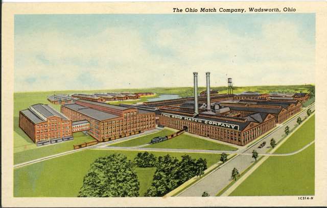
Photo: Columbus Metropolitan Library, via Digital Public Library of America, no known copyright restrictions · Wikimedia Commons
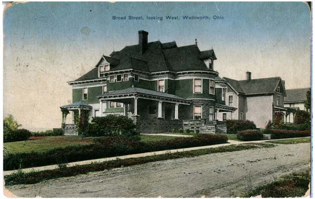
Photo: Columbus Metropolitan Library, via Digital Public Library of America, no known copyright restrictions · Wikimedia Commons
Local history sources: en.wikipedia.org · en.wikipedia.org · medinaco.org · commons.wikimedia.org
Historic places
1 place in Wadsworth on the National Register of Historic Places. Press a pin or a name for its whole record.
-
St. Mark's Episcopal ChurchBuilding · Wadsworth · listed 1973
- Address
- 146 College St.
- Where
- Wadsworth, Medina County · ZIP 44281
- What it is
- Building
- Listed on the National Register
- 1973
- NRIS reference number
- 73001506
- Coordinates
- 41.02579, -81.73137
National Register file (NPS) ↗ Search Wikipedia ↗ Street map and directions ↗ On the Cracked Buckeye map
Source: National Park Service, National Register of Historic Places point file. The listing year is shown where NPS's certification date agrees with the listing's reference number. Listing recognizes significance; it does not restrict a private owner.
Water
City wells drawing from local sandstone bedrock aquifers plus a well field roughly 6.5 miles away in Chippewa Township, Wayne County, tapping the Chippewa Creek buried-valley aquifer The water here
- Wadsworth City96% of residentsLocal groundwater wells (sandstone bedrock + Chippewa Creek buried-valley aquifer)
- Medina Co/northwest4% of residentsLake Erie
- Medina Co/sharon-wadsworth0% of residentsLocal groundwater wells (sandstone bedrock + Chippewa Creek buried-valley aquifer)
Hospitals, fire stations and more
Inside Wadsworth's boundary: 1 health center, 1 dialysis center, 2 nursing homes, 2 fire and EMS stations, 3 power plants, 1 high-hazard dam, 10 public schools, 1 private school, 1 library, 2 museums, 1 police station, 3 public charging sites, 19 Toxics Release Inventory facilities and 8 spill cases. Press a pin or a name for its whole record and its source.
Community health centers (1)
-
Medina County - WadsworthHealth center · Wadsworth
- Run by
- a federally qualified health center
- Setting
- Clinic
- City
- Wadsworth
- Coordinates
- 41.02717, -81.75445
Find a Health Center (HRSA) ↗ HRSA data (source) ↗ Street map and directions ↗
Source: HRSA health center service delivery sites, active, September 2026 (school-based sites left out). Health centers see patients whether or not they have insurance, with fees on a sliding scale.
Dialysis centers (1)
-
Fmc - Wadsworth DialysisDialysis · Wadsworth
- Address
- 1160 Williams Reserve Blvd., Wadsworth, OH 44281
- Dialysis stations
- 13
- Medicare star rating
- 3 of 5 stars
- Services
- in-center hemodialysis, peritoneal dialysis, home hemodialysis training
- Ownership
- for profit
- Chain
- Fresenius Medical Care
- Medicare certified since
- 2010-04-06
- Phone
- (330) 336-8070
- Medicare ID
- 362757
Medicare Care Compare ↗ CMS dialysis facility list (source) ↗ Street map and directions ↗
Source: CMS dialysis facility list, September 2026, geocoded with the Census Bureau batch geocoder (an address it could not place sits at its ZIP center).
Nursing homes (2)
-
Altercare of Wadsworth4 of 5 stars · Wadsworth
- Address
- 147 Garfield St, Wadsworth, OH 44281
- Certified beds
- 90
- Residents on an average day
- 66
- Medicare overall rating
- 4 of 5 stars
- Health inspections
- 3 of 5 stars
- Staffing
- 2 of 5 stars
- Quality measures
- 5 of 5 stars
- Penalties since 2023
- none
- Ownership
- For profit - Individual
- Chain
- ALTERCARE
- Takes
- Medicare and Medicaid
- Phone
- (330) 335-2555
- Medicare ID
- 365268
Medicare Care Compare ↗ CMS nursing home data (source) ↗ Street map and directions ↗
-
Wadsworth Pointe5 of 5 stars · Wadsworth
- Address
- 540 Great Oaks Trail, Wadsworth, OH 44281
- Certified beds
- 64
- Residents on an average day
- 55
- Medicare overall rating
- 5 of 5 stars
- Health inspections
- 5 of 5 stars
- Staffing
- 1 of 5 stars
- Quality measures
- 5 of 5 stars
- Penalties since 2023
- none
- Ownership
- For profit - Corporation
- Chain
- SABER HEALTHCARE GROUP
- Takes
- Medicare and Medicaid
- Phone
- (330) 336-1141
- Medicare ID
- 366237
Medicare Care Compare ↗ CMS nursing home data (source) ↗ Street map and directions ↗
Source: CMS Care Compare nursing home provider and penalties files; Medicare star ratings run 1 to 5.
Fire and EMS stations (2)
-
Wadsworth Fire Department and Emergency Medical Service Station 1Wadsworth
- Address
- 343 College Street, Wadsworth, OH 44281
- Coordinates
- 41.02515, -81.73854
USGS National Map structures (source) ↗ Street map and directions ↗
-
Wadsworth Fire Department and Emergency Medical Services Station 2Wadsworth
- Address
- 338 Weatherstone Drive, Wadsworth, OH 44281
- Coordinates
- 41.05878, -81.73797
USGS National Map structures (source) ↗ Street map and directions ↗
Source: USGS National Map structures (most Ohio records last updated 2019 to 2022), checked against the Columbus and Cleveland station lists. The department that answers a call is set by jurisdiction and mutual aid, not by distance.
Power plants (3)
-
DG AMP 1048 WadsworthSolar · 6 MW
- Capacity
- 6 MW
- Main source
- Solar
- Technology
- Solar Photovoltaic
- Operator
- DG AMP Solar, LLC
- Sector
- IPP Non-CHP
- Where
- Wadsworth, Medina County
- Generating units
- 1
- Built
- 2019
- EIA plant code
- 62942
EIA plant page ↗ EIA-860 (source) ↗ Street map and directions ↗
-
DG AMP Rittman RdSolar · 3 MW
- Capacity
- 3 MW
- Main source
- Solar
- Technology
- Solar Photovoltaic
- Operator
- DG AMP Solar, LLC
- Sector
- IPP Non-CHP
- Where
- Wadsworth, Medina County
- Generating units
- 1
- Built
- 2020
- EIA plant code
- 62941
EIA plant page ↗ EIA-860 (source) ↗ Street map and directions ↗
-
Wadsworth HBS RTO BTMPetroleum · 11 MW
- Capacity
- 11 MW
- Main source
- Petroleum
- Technology
- Petroleum Liquids
- Operator
- American Mun Power-Ohio, Inc
- Sector
- Electric Utility
- Where
- Wadsworth, Medina County
- Generating units
- 4
- Built
- 2020
- EIA plant code
- 66464
EIA plant page ↗ EIA-860 (source) ↗ Street map and directions ↗
Source: EIA-860 power plant inventory via HIFLD (February 2025), with plant codes, units and years from EIA-860 2025.
High-hazard dams (1)
-
Brye Lake Dam PoorUnnamed tributary to Holmes Brook · condition: poor
- Hazard class
- High: a failure would probably cost a life
- Condition
- Poor (assessed 06/24/2020)
- River or stream
- Unnamed tributary to Holmes Brook
- Purpose
- Recreation
- Type
- Earth
- Height
- 12 ft
- Storage
- 23 acre-feet
- Completed
- 1988
- Owner type
- Private
- County
- Medina County
- Nearest town (NID)
- Sterling Oaks Sr Complex
- Last inspection
- 06/04/2025
- Emergency action plan
- No
- NID ID
- OH03057
National Inventory of Dams record ↗ National Inventory of Dams (source) ↗ Street map and directions ↗
Source: U.S. Army Corps of Engineers National Inventory of Dams, August 2026. "High hazard" rates what a failure would cost downstream, not how likely one is; the condition is the state's assessment.
Public schools (10)
-
Central Intermediate SchoolWadsworth
- Address
- 151 Main St, Wadsworth, OH 44281
- Kind (NCES)
- Regular School
- Students, 2023-24
- 584
- Teachers (full-time equivalent)
- 29.24
- NCES school ID
- 391002903600
-
Franklin Elementary School4 of 5 stars · Wadsworth
- Address
- 200 Takacs Dr, Wadsworth, OH 44281
- School district
- Wadsworth City School District
- Kind (NCES)
- Regular School
- Students, 2023-24
- 248
- Teachers (full-time equivalent)
- 14.95
- Report card, 2025-26
- 4 of 5 stars
- Performance index
- 89.2%
- Ohio building IRN
- 012286
- NCES school ID
- 391002901892
NCES school record ↗ Ohio School Report Card ↗ Street map and directions ↗
-
Grizzly Academy1.5 of 5 stars · Wadsworth
- Address
- 524 Broad St, Wadsworth, OH 44281
- School district
- Wadsworth City School District
- Kind (NCES)
- Regular School
- Students, 2023-24
- 16
- Teachers (full-time equivalent)
- 2.3
- Report card, 2025-26
- 1.5 of 5 stars
- Performance index
- 44.3%
- Ohio building IRN
- 020854
- NCES school ID
- 391002910877
NCES school record ↗ Ohio School Report Card ↗ Street map and directions ↗
-
Isham Memorial Elementary School4 of 5 stars · Wadsworth
- Address
- 325 Sunset Blvd, Wadsworth, OH 44281
- School district
- Wadsworth City School District
- Kind (NCES)
- Regular School
- Students, 2023-24
- 354
- Teachers (full-time equivalent)
- 19.64
- Report card, 2025-26
- 4 of 5 stars
- Performance index
- 87.5%
- Ohio building IRN
- 017533
- NCES school ID
- 391002901893
NCES school record ↗ Ohio School Report Card ↗ Street map and directions ↗
-
Lincoln Elementary School3 of 5 stars · Wadsworth
- Address
- 280 N Lyman St, Wadsworth, OH 44281
- School district
- Wadsworth City School District
- Kind (NCES)
- Regular School
- Students, 2023-24
- 226
- Teachers (full-time equivalent)
- 12.75
- Report card, 2025-26
- 3 of 5 stars
- Performance index
- 79.8%
- Ohio building IRN
- 020784
- NCES school ID
- 391002901894
NCES school record ↗ Ohio School Report Card ↗ Street map and directions ↗
-
Overlook Elementary School5 of 5 stars · Wadsworth
- Address
- 650 Broad St, Wadsworth, OH 44281
- School district
- Wadsworth City School District
- Kind (NCES)
- Regular School
- Students, 2023-24
- 399
- Teachers (full-time equivalent)
- 21.99
- Report card, 2025-26
- 5 of 5 stars
- Performance index
- 93.8%
- Ohio building IRN
- 028969
- NCES school ID
- 391002901895
NCES school record ↗ Ohio School Report Card ↗ Street map and directions ↗
-
Valley View Elementary School3.5 of 5 stars · Wadsworth
- Address
- 625 Orchard St, Wadsworth, OH 44281
- School district
- Wadsworth City School District
- Kind (NCES)
- Regular School
- Students, 2023-24
- 330
- Teachers (full-time equivalent)
- 22.48
- Report card, 2025-26
- 3.5 of 5 stars
- Performance index
- 86.1%
- Ohio building IRN
- 038158
- NCES school ID
- 391002901896
NCES school record ↗ Ohio School Report Card ↗ Street map and directions ↗
-
Wadsworth City School District Online AcademyWadsworth
- Address
- 524 Broad St, Wadsworth, OH 44281
- Kind (NCES)
- Regular School
- Students, 2023-24
- 8
- NCES school ID
- 391002906080
-
Wadsworth High School4.5 of 5 stars · Wadsworth
- Address
- 625 Broad St, Wadsworth, OH 44281
- School district
- Wadsworth City School District
- Kind (NCES)
- Regular School
- Students, 2023-24
- 1,591
- Teachers (full-time equivalent)
- 81.26
- Report card, 2025-26
- 4.5 of 5 stars
- Performance index
- 88.8%
- Four-year graduation rate
- 96.9%
- Ohio building IRN
- 038935
- NCES school ID
- 391002901897
NCES school record ↗ Ohio School Report Card ↗ Street map and directions ↗
-
Wadsworth Middle School4 of 5 stars · Wadsworth
- Address
- 150 Silvercreek Rd, Wadsworth, OH 44281
- School district
- Wadsworth City School District
- Kind (NCES)
- Regular School
- Students, 2023-24
- 634
- Teachers (full-time equivalent)
- 42.46
- Report card, 2025-26
- 4 of 5 stars
- Performance index
- 85.8%
- Ohio building IRN
- 005710
- NCES school ID
- 391002901891
NCES school record ↗ Ohio School Report Card ↗ Street map and directions ↗
Source: NCES EDGE public school locations 2024-25 and Common Core of Data 2023-24 (type, students, teachers); Ohio School Report Cards 2025-26 (Department of Education and Workforce), matched by name within the district.
Private schools (1)
-
Sacred Heart of Jesus Catholic SchoolPrivate, Catholic · Wadsworth
- Address
- 110 Humbolt Ave, Wadsworth, OH 44281
- Kind
- Catholic
- Students, 2023-24
- 210
- Teachers (full-time equivalent)
- 18.5
- Students per teacher
- 11.3514
- Phone
- (330) 334-6272
- NCES private school ID
- A2302256
Source: NCES Private School Survey 2023-24.
Public libraries (1)
-
Ella M. Everhard Public LibraryCentral library · Wadsworth
- Address
- 132 Broad St., Wadsworth, OH 44281
- What it is
- Central library
- Library system
- Ella M. Everhard Public Library
- Open
- 3,640 hours a year, 52 weeks
- Building
- 19,506 sq ft
- System's visits, FY2024
- 138,944
- System's loans, FY2024
- 556,023
- People the system serves
- 28,621
- Phone
- (330) 334-5761
IMLS Public Libraries Survey (source) ↗ Street map and directions ↗
Source: IMLS Public Libraries Survey FY2024 (outlets and their systems). Any Ohio resident can get a free card at any Ohio public library.
Museums, historical societies, gardens and zoos (2)
-
National Air Racing MuseumMuseum · Wadsworth
- What it is
- Museum
- City
- Wadsworth
- Coordinates
- 41.06441, -81.72585
Search Wikipedia ↗ IMLS Museum Data Files (source) ↗ Street map and directions ↗
The museum list is IMLS's 2018 file; a museum may have closed or moved since.
-
Wadsworth Area Historical SocietyHistorical society · Wadsworth
- What it is
- Historical society
- City
- Wadsworth
- Coordinates
- 41.02784, -81.72958
Search Wikipedia ↗ IMLS Museum Data Files (source) ↗ Street map and directions ↗
The museum list is IMLS's 2018 file; a museum may have closed or moved since.
Source: IMLS Museum Data Files, 2018.
Police stations (1)
-
Wadsworth Police DepartmentWadsworth
- Address
- 120 Maple Street, Wadsworth, OH 44281
- Coordinates
- 41.02720, -81.72898
USGS National Map structures (source) ↗ Street map and directions ↗
Source: USGS National Map structures, police stations, corrected and completed by hand (September 2026). The department that answers a call is set by jurisdiction, not by distance.
Public EV charging (3)
-
Comfort Inn & Suites Wadsworth - Tesla Destination3 Level 2 · Wadsworth
- Address
- 5 Park Center Dr, Wadsworth, OH 44281
- Ports
- 3 Level 2
- Plugs
- J1772, Tesla (NACS)
- Network
- Tesla Destination
- Phone
- 877-798-3752
Station Locator (NREL) ↗ Alternative Fuels Data Center (source) ↗ Street map and directions ↗
-
King Street Parking Lot - Level 2 (Standard) Chargers2 Level 2 · Wadsworth
- Address
- 129 King Street, Wadsworth, OH 44281
- Ports
- 2 Level 2
- Plugs
- J1772
- Network
- FLO
- Hours
- 24 hours daily
- Phone
- 888-356-8911
Station Locator (NREL) ↗ Alternative Fuels Data Center (source) ↗ Street map and directions ↗
-
King Street Parking Lot - Level 3 (Fast) Charger DC fast1 DC fast · Wadsworth
- Address
- 120 Maple Street, Wadsworth, OH 44281
- Ports
- 1 DC fast
- Plugs
- CCS, CHAdeMO
- Network
- FLO
- Hours
- 24 hours daily
- Phone
- 888-356-8911
Station Locator (NREL) ↗ Alternative Fuels Data Center (source) ↗ Street map and directions ↗
Source: NREL Alternative Fuels Data Center station list (May 2026), public and open stations, the posts at one address counted as one site.
Facilities reporting toxic releases (19)
-
Admiral Machine Division of Cable TechnologiesToxics Release Inventory · Wadsworth
- Address
- 931 Seville Rd, Wadsworth, OH 44281
- County
- Medina County
- Status
- Reports to the Toxics Release Inventory (active)
- EPA program ID
- 44281DMRLC931SE
- EPA registry ID
- 110006209753
EPA facility record ↗ EPA Facility Registry Service (source) ↗ Street map and directions ↗
-
Advanced Elastomer Systems L PToxics Release Inventory · Wadsworth
- Address
- 1000 Seville Rd, Wadsworth, OH 44281
- County
- Medina County
- Status
- Reports to the Toxics Release Inventory (active)
- EPA program ID
- 44281MNSNT1000S
- EPA registry ID
- 110000389160
EPA facility record ↗ EPA Facility Registry Service (source) ↗ Street map and directions ↗
-
Bmca Insulation Products IncToxics Release Inventory · Wadsworth
- Address
- 470 Suth Main St, Wadsworth, OH 44281
- County
- Medina County
- Status
- Reports to the Toxics Release Inventory (closed)
- EPA program ID
- 44281BMCNS470SU
- EPA registry ID
- 110002111492
EPA facility record ↗ EPA Facility Registry Service (source) ↗ Street map and directions ↗
-
Ebner Furnaces, Inc.Toxics Release Inventory · Wadsworth
- Address
- 224 Quadral Drive, Wadsworth, OH 44281
- County
- Medina County
- Status
- Reports to the Toxics Release Inventory (active)
- EPA program ID
- 44281BNRFR224QU
- EPA registry ID
- 110001620915
EPA facility record ↗ EPA Facility Registry Service (source) ↗ Street map and directions ↗
-
Fluid Tite Castings LtdToxics Release Inventory · Wadsworth
- Address
- 1030 Seville Rd., Wadsworth, OH 44281
- County
- Medina County
- Status
- Reports to the Toxics Release Inventory (active)
- EPA program ID
- 44281CLFFC1030S
- EPA registry ID
- 110000389133
EPA facility record ↗ EPA Facility Registry Service (source) ↗ Street map and directions ↗
-
Goldsmith & Eggleton, IncToxics Release Inventory · Wadsworth
- Address
- 300 First Street, Wadsworth, OH 44281
- County
- Medina County
- Status
- Reports to the Toxics Release Inventory (active)
- EPA program ID
- 4428WGLDSM3FIRS
- EPA registry ID
- 110009821434
EPA facility record ↗ EPA Facility Registry Service (source) ↗ Street map and directions ↗
-
Jc Whitlam ManufacturingToxics Release Inventory · Wadsworth
- Address
- 200 W. Walnut St., Wadsworth, OH 44281
- County
- Medina County
- Status
- Reports to the Toxics Release Inventory (active)
- EPA program ID
- 44281JCWHT200WE
- EPA registry ID
- 110000389151
EPA facility record ↗ EPA Facility Registry Service (source) ↗ Street map and directions ↗
-
Kleen PolymersToxics Release Inventory · Wadsworth
- Address
- 145 Rainbow Street, Wadsworth, OH 44281
- County
- Medina County
- Status
- Reports to the Toxics Release Inventory
- EPA program ID
- 4428WPRFRR145RA
- EPA registry ID
- 110059574358
EPA facility record ↗ EPA Facility Registry Service (source) ↗ Street map and directions ↗
-
Luke Engineering and Mfg Co IncToxics Release Inventory · Wadsworth
- Address
- 456 South Blvd, Wadsworth, OH 44281
- County
- Medina County
- Status
- Reports to the Toxics Release Inventory (active)
- EPA program ID
- 44281LKMFG456SO
- EPA registry ID
- 110000766662
EPA facility record ↗ EPA Facility Registry Service (source) ↗ Street map and directions ↗
-
National Metal Abrasive CompanyToxics Release Inventory · Wadsworth
- Address
- 142 Auble St., Wadsworth, OH 44281
- County
- Medina County
- Status
- Reports to the Toxics Release Inventory (active)
- EPA program ID
- 44281NTNLM142AU
- EPA registry ID
- 110000389179
EPA facility record ↗ EPA Facility Registry Service (source) ↗ Street map and directions ↗
-
Novex IncToxics Release Inventory · Wadsworth
- Address
- 258 Main St., Wadsworth, OH 44281
- County
- Medina County
- Status
- Reports to the Toxics Release Inventory (active)
- EPA program ID
- 44281NVXNC258SO
- EPA registry ID
- 110000389188
EPA facility record ↗ EPA Facility Registry Service (source) ↗ Street map and directions ↗
-
Parker HannifinToxics Release Inventory · Wadsworth
- Address
- 135 Quadral Dr, Wadsworth, OH 44281
- County
- Medina County
- Status
- Reports to the Toxics Release Inventory (active)
- EPA program ID
- 4428WPRKRH135QU
- EPA registry ID
- 110067126318
EPA facility record ↗ EPA Facility Registry Service (source) ↗ Street map and directions ↗
-
Physics International CoToxics Release Inventory · Wadsworth
- Address
- 901 Seville Rd., Wadsworth, OH 44281
- County
- Medina County
- Status
- Reports to the Toxics Release Inventory (active)
- EPA program ID
- 44281PHYSC901SE
- EPA registry ID
- 110002111508
EPA facility record ↗ EPA Facility Registry Service (source) ↗ Street map and directions ↗
-
Preferred Compounding Corp.Toxics Release Inventory · Wadsworth
- Address
- 145 Rainbow St, Wadsworth, OH 44281
- County
- Medina County County
- Status
- Reports to the Toxics Release Inventory
- EPA program ID
- 4428WPRFRR145RB
- EPA registry ID
- 110070559779
EPA facility record ↗ EPA Facility Registry Service (source) ↗ Street map and directions ↗
-
Remington Products CompanyToxics Release Inventory · Wadsworth
- Address
- 961 Seville Rd, Wadsworth, OH 44281
- County
- Medina County
- Status
- Reports to the Toxics Release Inventory (active)
- EPA program ID
- 4428WRMNGT961SE
- EPA registry ID
- 110012175243
EPA facility record ↗ EPA Facility Registry Service (source) ↗ Street map and directions ↗
-
Rohrer Corporation (1652100108)Toxics Release Inventory · Wadsworth
- Address
- 717 Seville Rd, Wadsworth, OH 44281
- County
- Medina County
- Status
- Reports to the Toxics Release Inventory (***unchanged***)
- EPA program ID
- 4428WRHRRX717SE
- EPA registry ID
- 110004692128
EPA facility record ↗ EPA Facility Registry Service (source) ↗ Street map and directions ↗
-
Soprema Headquarters AdditionToxics Release Inventory · Wadsworth
- Address
- 310 Quadral Drive, Wadsworth, OH 44281
- County
- Medina County
- Status
- Reports to the Toxics Release Inventory (active)
- EPA program ID
- 4428WSPRMS31QUA
- EPA registry ID
- 110006293420
EPA facility record ↗ EPA Facility Registry Service (source) ↗ Street map and directions ↗
-
Sun Chemical Corporation Packaging Ink DivisionToxics Release Inventory · Wadsworth
- Address
- 471 E. Bergey St., Wadsworth, OH 44281
- County
- Medina County
- Status
- Reports to the Toxics Release Inventory (active)
- EPA program ID
- 44281THLNG471EB
- EPA registry ID
- 110000814691
EPA facility record ↗ EPA Facility Registry Service (source) ↗ Street map and directions ↗
-
Western Roto Engravers IncToxics Release Inventory · Wadsworth
- Address
- 668 Seville Road, Wadsworth, OH 44281
- County
- Medina County
- Status
- Reports to the Toxics Release Inventory (active)
- EPA program ID
- 44281WSTRN668SE
- EPA registry ID
- 110000850703
EPA facility record ↗ EPA Facility Registry Service (source) ↗ Street map and directions ↗
Source: EPA Facility Registry Service, Toxics Release Inventory reporters. Reporting a release is required of large users of listed chemicals; it is not by itself a violation.
Spills reported since 2021 (8)
-
Fish Kill Reached water2025-07-14 · Wadsworth
- Reported
- 2025-07-14
- What spilled
- Fish Kill
- Reached a waterway
- 99 - Unnamed
- Where
- Wadsworth, Medina County
- Ohio EPA district office
- NEDO
- Ohio EPA case number
- 2507EPA0001167
Ohio EPA spill reports (source) ↗ Street map and directions ↗
-
Fuel Diesel / Diesel Fuel (Vehicle On Or Off Road)2024-09-07 · Wadsworth
- Reported
- 2024-09-07
- What spilled
- Fuel Diesel / Diesel Fuel (Vehicle On Or Off Road)
- Largest amount reported
- 100 gallons
- Where
- Wadsworth, Medina County
- Ohio EPA district office
- NEDO
- Ohio EPA case number
- 2409EPA0001541
Ohio EPA spill reports (source) ↗ Street map and directions ↗
-
Fuel Diesel / Diesel Fuel (Vehicle On Or Off Road)2024-03-20 · Wadsworth
- Reported
- 2024-03-20
- What spilled
- Fuel Diesel / Diesel Fuel (Vehicle On Or Off Road)
- Where
- Wadsworth, Medina County
- Ohio EPA district office
- NEDO
- Ohio EPA case number
- 2403EPA0000441
Ohio EPA spill reports (source) ↗ Street map and directions ↗
-
Fuel Diesel / Diesel Fuel (Vehicle On Or Off Road)2023-04-08 · Wadsworth
- Reported
- 2023-04-08
- What spilled
- Fuel Diesel / Diesel Fuel (Vehicle On Or Off Road)
- Where
- Wadsworth, Medina County
- Ohio EPA district office
- NEDO
- Ohio EPA case number
- 2304EPA0000536
Ohio EPA spill reports (source) ↗ Street map and directions ↗
-
Fuel Diesel / Diesel Fuel (Vehicle On Or Off Road)2022-05-05 · Wadsworth
- Reported
- 2022-05-05
- What spilled
- Fuel Diesel / Diesel Fuel (Vehicle On Or Off Road)
- Largest amount reported
- 75 gallons
- Where
- Wadsworth, Medina County
- Ohio EPA district office
- NEDO
- Ohio EPA case number
- 2205EPA0000634
Ohio EPA spill reports (source) ↗ Street map and directions ↗
-
Oil Petroleum Not Otherwise Specified (Nos)2022-04-22 · Wadsworth
- Reported
- 2022-04-22
- What spilled
- Oil Petroleum Not Otherwise Specified (Nos)
- Where
- Wadsworth, Medina County
- Ohio EPA district office
- NEDO
- Ohio EPA case number
- 2204EPA0000557
Ohio EPA spill reports (source) ↗ Street map and directions ↗
-
Material Unknown2021-04-01 · Wadsworth Twp
- Reported
- 2021-04-01
- What spilled
- Material Unknown
- Where
- Wadsworth Twp, Medina County
- Ohio EPA district office
- NEDO
- Ohio EPA case number
- 2104EPA0000443
Ohio EPA spill reports (source) ↗ Street map and directions ↗
-
Sewage Sludge / Biosolids2026-02-23 · Wadsworth
- Reported
- 2026-02-23
- What spilled
- Sewage Sludge / Biosolids
- Where
- Wadsworth, Medina County
- Ohio EPA district office
- NEDO
- Ohio EPA case number
- 2602EPA0000228
Ohio EPA spill reports (source) ↗ Street map and directions ↗
Source: Ohio EPA emergency response spill reports, 2021 to September 2026, one point per case where Ohio EPA placed it. A report is what the caller or responder recorded; amounts are often blank or estimated.
Its ZIP codes
Each ZIP code that touches Wadsworth, with the share of its residents who live here and the same headline figures as the ZIP page.
| ZIP | Share | Water | Radon | Home value | Schools | Flood |
|---|---|---|---|---|---|---|
| 44281 Wadsworth | 72% | City wells drawing from local sandstone bedrock aquifers plus a well field roughly 6.5 miles away in Chippewa Township, Wayne County, tapping the Chippewa Creek buried-valley aquifer | 3.8 pCi/L average radon | Median year built 1977 | Wadsworth City · 4.5 stars overall | 1.1% of residents in the 1% floodplain |
Local government
Who holds office in Wadsworth, how its elections and ballot issues came out, and the state auditor's record.
Money issues on the ballot since 2021: 2 of 2 passed.
Ballot issues
| Date | Issue | For | Against | Result |
|---|---|---|---|---|
| 2022-11-08 | 13: 13 Proposed Tax Levy City of Wadsworth | 6,195 | 2,880 | Passed (68.26% for), unofficial |
| 2021-11-02 | 7: 7 Proposed Municipal Income Tax Wadsworth City | 3,036 | 1,694 | Passed (64.19% for), unofficial |
Elections for office
| Date | Office | Candidates and votes |
|---|---|---|
| 2025-11-04 | Treasurer (unofficial count) | Christian Baughman (REP) 1,829, 100.0% |
| 2025-11-04 | President of Council (unofficial count) | Daniel J. Rospert (REP) 1,855, 100.0% |
| 2025-11-04 | Member of Council, Ward 4 (unofficial count) | Angela May (DEM) 350, 50.0%; David Parish (REP) 350, 50.0% |
| 2025-11-04 | Member of Council, Ward 3 (unofficial count) | Jeanne Hines (REP) 115, 43.4%; John Allen Schulze (DEM) 150, 56.6% |
| 2025-11-04 | Member of Council, Ward 2 (unofficial count) | Jon Yurchiak (REP) 523, 100.0% |
| 2025-11-04 | Member of Council, Ward 1 (unofficial count) | Ralph J. Copley (REP) 485, 45.03%; Mike Reese (DEM) 592, 54.97% |
| 2025-11-04 | Member of Council at Large (unofficial count) | Zach Berger (REP) 1,347, 31.26%; Chris Maxwell (REP) 1,368, 31.75%; Thomas Stugmyer (REP) 1,594, 36.99% |
| 2023-11-07 | President of Council (unofficial count) | David L. Williams (REP) 6,169, 100.0% |
| 2023-11-07 | Mayor (unofficial count) | Robin Laubaugh (REP) 6,990, 100.0% |
| 2023-11-07 | Auditor (unofficial count) | Catherine Fix (REP) 6,270, 100.0% |
| 2023-05-02 | Mayor (REP primary) | Robin Laubaugh 2,052, 61.13%; Bob Thurber 1,305, 38.87% |
| 2021-11-02 | Treasurer (unofficial count) | Lisa M. Jones (REP) 3,643, 100.0% |
| 2021-11-02 | President of Council (unofficial count) | Bob Thurber (REP) 3,658, 100.0% |
| 2021-11-02 | Member of Council, Ward 4 (unofficial count) | Bruce Darlington (REP) 583, 59.49%; Michael Reese (DEM) 397, 40.51% |
| 2021-11-02 | Member of Council, Ward 3 (unofficial count) | Jeanne Hines (REP) 586, 60.54%; Justin Terrill (DEM) 382, 39.46% |
| 2021-11-02 | Member of Council, Ward 2 (unofficial count) | Jon Yurchiak (REP) 1,068, 100.0% |
| 2021-11-02 | Member of Council, Ward 1 (unofficial count) | Ralph J. Copley (REP) 792, 59.95%; Joy Martin (DEM) 529, 40.05% |
| 2021-11-02 | Member of Council at Large (unofficial count) | Patricia Haskins (DEM) 2,237, 20.81%; Daniel J. Rospert (REP) 2,751, 25.6%; Thomas A. Stugmyer (REP) 2,918, 27.15%; David L. Williams (REP) 2,842, 26.44% |
| 2019-11-05 | President of Council | Bob Thurber (REP) 2,229, 100.0% |
| 2019-11-05 | Member of Council, Ward 4 | Bruce Darlington (REP) 479, 100.0% |
| 2019-11-05 | Member of Council, Ward 3 | Jeanne L. Hines (REP) 349, 65.36%; Lee R. Potts (DEM) 185, 34.64% |
| 2019-11-05 | Member of Council, Ward 2 | Jon Yurchiak (REP) 629, 100.0% |
| 2019-11-05 | Member of Council, Ward 1 | Ralph J. Copley (REP) 677, 100.0% |
| 2019-11-05 | Member of Council at Large | Patricia Haskins (DEM) 1,819, 32.72%; Thomas Stugmyer (REP) 1,888, 33.96%; David L. Williams (REP) 1,852, 33.32% |
| 2019-11-05 | Mayor | Robin Laubaugh (REP) 2,342, 100.0% |
Winners in bold. Results from the county board of elections' official canvass unless marked.
Auditor of State record
- No fiscal caution, watch or emergency on the Auditor of State's lists.
- Financial Health Indicators (the Auditor of State's 17 measures; critical / cautionary / positive): 2020 0 / 0 / 17; 2021 0 / 0 / 17; 2022 0 / 1 / 16; 2023 0 / 1 / 16; 2024 0 / 3 / 14; 2025 0 / 3 / 14.
- Financial Audit, 2025, released 2026-08-11
- Compliance Examination, 2024, released 2026-06-02
- OP&F Examination, 2024, released 2026-05-14
- Financial Audit, 2024, released 2025-12-09
- Financial Audit, 2023, released 2024-09-12
The county
Medina County: 13 ZIP codes, 26 cities, villages and townships, 180,994 people.
Nearby places
Rain and snow
How much has actually fallen on Wadsworth, day by day, from 1893 to now. Daily totals, not averages.
- rain, last 30 days
- 1.85 in
- 2026-09-30 to 2026-10-29
- rain so far in 2026
- 37.2 in
- 3.1 in above normal for the date
- snow so far in 2026
- 30.6 in
- a normal year brings 40.6 in
- a normal year
- 40.0 in
- average of 30 years, 1991-2020
| Month | Rain (in) | Snow (in) | Days counted |
|---|---|---|---|
| October 2026 | 1.85 | — | 29 |
| September 2026 | 4.32 | — | 30 |
| August 2026 | 4.40 | — | 31 |
| July 2026 | 3.79 | — | 31 |
| June 2026 | 3.43 | — | 30 |
| May 2026 | 5.04 | — | 31 |
| April 2026 | 7.14 | 0.1 | 30 |
| March 2026 | 4.49 | 1.4 | 31 |
| February 2026 | 0.86 | 8.9 | 28 |
| January 2026 | 1.92 | 20.3 | 31 |
| December 2025 | 2.40 | 12.3 | 31 |
| November 2025 | 1.59 | 3.8 | 30 |
| Wettest year | 2011 — 59.7 in |
|---|---|
| Driest year | 1963 — 23.6 in |
| Snowiest year | 2010 — 77.1 in |
| Wettest day on record | 5 July 1969 — 5.36 in |
| Heaviest snowfall in a day | 9 November 1913 — 17.90 in |
| Deepest snow on the ground | 9 November 1913 — 22.01 in |
Estimated, not measured. No rain gauge has ever stood inside Wadsworth, so every figure here is worked out from the gauges around it - the nearest ones weighted most. Treat them as close estimates rather than readings.
48,624 days of records, 1893-01-01 to 2026-10-29. Source: NOAA NCEI GHCN-Daily, 3,240 gauges in and around Ohio. A day is "gauged" when a gauge standing inside the boundary reported it, and the value is the mean of those gauges. Otherwise it is interpolated by inverse distance from every gauge reporting within 50 miles. Nothing is carried forward, back-filled or smoothed. Against NOAA nClimDiv county monthly precipitation over 136,848 complete county-months (checked 2026-10-31): correlation 0.9515, median absolute difference 0.217 in a month. Built 2026-10-31 from the Cracked Buckeye precipitation archive. Snow is the softer number — snowfall is measured by hand with a ruler, no agency publishes a gridded county snowfall series, and blowing snow defeats every observer.
Environmental permits and filings
What Ohio EPA has on file for Wadsworth: permits, inspections, violations, cleanups and the state loans behind sewer and water work. Every line links to the agency's own document.
- facilities and sites on file
- 84
- those placed on the map inside Wadsworth
| Program | Facilities and sites |
|---|---|
| Air pollution | 24 |
| Hazardous waste | 16 |
| Wastewater and stormwater discharge | 16 |
| Site assessment | 6 |
| State water loans | 5 |
| Sewer and water-line construction | 4 |
| State sewer loans | 3 |
| Wetland and stream fill | 3 |
| Contaminated-site cleanup | 1 |
| Landfills | 1 |
| Municipal Solid Waste Transfer Facilities | 1 |
| Public drinking water | 1 |
| 3 smaller programs |
| Date | Facility or site | What |
|---|---|---|
| WADSWORTH CITY PWS | Public drinking water compliance letter | |
| WESTERN ROTO ENGRAVERS INC | Air pollution report | |
| WADSWORTH SOLID WASTE TRANSFER FACILITY | Municipal Solid Waste Transfer Facilities inspection | |
| WADSWORTH CITY PWS | Public drinking water violation resolved | |
| WADSWORTH CITY PWS | State water loans | |
| WADSWORTH CITY PWS | Public drinking water notice of violation | |
| WADSWORTH CITY PWS | Public drinking water compliance letter | |
| WADSWORTH CITY PWS | State water loans | |
| WESTERN ROTO ENGRAVERS INC | Hazardous waste notice of violation | |
| WADSWORTH CITY PWS | State water loans | |
| WADSWORTH WWTP | State sewer loans | |
| CHICK-FIL-A INC - FSU 06186 WADSWORTH | Wastewater and stormwater discharge permit | |
| CREEKSIDE COMMONS PHASE 1 | Wastewater and stormwater discharge permit | |
| WADSWORTH CITY PWS | Public drinking water plan | |
| HIGHLANDS OF SHARON PHASE 3 | Sewer and water-line construction permit | |
| HIGHLANDS OF SHARON PHASE 3 | Sewer and water-line construction permit | |
| WADSWORTH SOLID WASTE TRANSFER FACILITY | Municipal Solid Waste Transfer Facilities inspection | |
| WADSWORTH CITY PWS | Public drinking water plan | |
| WADSWORTH CITY PWS | Public drinking water inspection | |
| CHICK-FIL-A INC - FSU 06186 WADSWORTH | Wastewater and stormwater discharge permit | |
| WADSWORTH WWTP | State sewer loans | |
| BRICKYARD RECREATIONAL DEVELOPMENT | Wetland and stream fill permit | |
| WADSWORTH WWTP | State sewer loans | |
| BRICKYARD RECREATIONAL DEVELOPMENT | Wetland and stream fill permit | |
| WADSWORTH CITY PWS | Public drinking water plan |
Source: Ohio EPA eDocument portal (edocpub.epa.ohio.gov), indexed 2026-10-14. Facilities are placed on the map from Ohio EPA's own map layers, EPA's Facility Registry, coordinates written in the filings, or a geocoded street address. A permit filed under a private person's name (most are household septic systems) is counted but never named, placed or linked; licenses for individual workers and open-burning notices are left out entirely.
Quick answers
What county is Wadsworth, Ohio in?
Wadsworth is a city in Medina County, Ohio, with 24,003 residents.
When was Wadsworth, Ohio founded?
Wadsworth was settled 1814-03-01; incorporated 1876-01-01 (village); 1931-01-01 (city). Founders on record: settled on land largely owned by General Elijah Wadsworth. Source
How did Wadsworth, Ohio get its name?
The town was named for General Elijah Wadsworth (1747-1817), a Revolutionary War and War of 1812 officer who was the largest single landowner in the territory that became Medina County. Source
What ZIP code is Wadsworth, Ohio?
Most of Wadsworth is in ZIP code 44281.
Where does Wadsworth, Ohio get its water?
The main water source for Wadsworth (Wadsworth City): City wells drawing from local sandstone bedrock aquifers plus a well field roughly 6.5 miles away in Chippewa Township, Wayne County, tapping the Chippewa Creek buried-valley aquifer.
Cite this page
Cite this page as:
Cracked Buckeye, "Wadsworth, Medina County", https://crackedbuckeye.com/place/wadsworth/, built 2026-10-31, accessed [date].
How to cite · Report a correction · Built 2026-10-31
