Local events in Upper Sandusky
10 events in the next 90 days from 4 public calendars. All local events in Upper Sandusky
Checked October 20; the events page is refreshed daily.
Deep dives about Upper Sandusky
Long reads built from maps, newspapers and public records. All deep dives
History from Upper Sandusky
People and inventions tied to this place, each with its sources. All people · All inventions
How Upper Sandusky began
Upper Sandusky grew up beside a Wyandot town of the same name that stood here through the Revolutionary era, was the seat of the twelve-mile-square Wyandot reservation from 1817 to 1843, and became a white settlers' town only after the tribe's 1843 removal to Kansas. It was platted in 1843 and named for its position near the headwaters of the Sandusky River. It became the seat of newly organized Wyandot County in 1845 and grew as a farm-trade and rail town; it is now the county's largest city and its government and commercial center.
Settled 1843, platted 1843, incorporated 1848 (sources are unclear whether this is the year of incorporation or of becoming county seat), by settlers following the 1843 Wyandot removal; laid out near the site of the former Wyandot town and reservation.
Where the name comes from
The city takes its name from an earlier Wyandot town on the same site, itself named for its location near the headwaters (the 'upper' reaches) of the Sandusky River, which flows north to Lake Erie at the city of Sandusky.
Before the town
Upper Sandusky was one of the principal Wyandot towns of the late 1700s, known also as Half-King's Town after the Wyandot leader Dunquat (the 'Half-King'), and was allied with British forces at Detroit during the Revolutionary War. In 1782 Pennsylvania militia under Col. William Crawford marched on the Sandusky towns; the expedition was defeated nearby and Crawford was captured and burned at the stake (see Crawford Township for the execution site). The 1817 Treaty of the Maumee Rapids (Fort Meigs) and 1818 Treaty of St. Marys set aside a 12-mile-square Wyandot reservation, the 'Grand Reserve,' centered on Upper Sandusky; it held over 100 log houses, a gristmill, orchards, and the Wyandot Mission (Methodist) with its 1824 mission church, still standing as the Wyandot Mission Church (NRHP 1976; the Indian Mill is a separate listing). The reservation was ceded under the 1842 Treaty with the Wyandot, and in July 1843 the remaining Wyandot were removed to Kansas -- the last tribal nation to leave Ohio under the federal removal policy. The present city was platted after that removal.
Nations recorded here: Wyandot.
- Upper Sandusky Reservation (the Grand Reserve) (other) — surrounding Upper Sandusky, Wyandot County, 1817-1843 (en.wikipedia.org)
- Wyandot Mission Church (other) — Upper Sandusky, on the site of the reservation mission, built 1824 (npgallery.nps.gov)
- Fort Ferree (other) — Upper Sandusky, built as a War of 1812 supply post under Gen. William Henry Harrison, 1812 (en.wikipedia.org)
Timeline
- — Pennsylvania militia under Col. William Crawford attacked the Wyandot/Delaware towns around Upper Sandusky (Half-King's Town) and were defeated; Crawford was captured and executed nearby.
- — Fort Ferree was built at Upper Sandusky as a supply depot for Gen. William Henry Harrison's Army of the Northwest.
- — The Treaty of the Maumee Rapids (Fort Meigs) set aside the twelve-mile-square Wyandot reservation at Upper Sandusky, enlarged by the 1818 Treaty of St. Marys.
- — The Wyandot Mission church was built on the reservation, the center of the Methodist mission begun by John Stewart.
- — Under the 1842 treaty ceding the reservation, the remaining Wyandot were removed from Upper Sandusky to Kansas in July, the last Native nation to leave Ohio under removal policy; the modern town was platted the same year.
- — Wyandot County was organized by the state legislature from parts of Crawford, Marion, Hardin and Hancock counties, with Upper Sandusky as county seat.
- — The city's lime-softening water treatment plant was built in a flood plain; it was still in use when the city had it evaluated for replacement, with some parts nearly 120 years old.
Stories
A town built where a nation was removed
Upper Sandusky is unusual among Ohio county seats in that its site was continuously a Native town before it was a settler town. Wyandot people lived here through the Revolutionary War as Half-King's Town, and after 1817 it was the administrative heart of the Grand Reserve, the last large Wyandot landholding in Ohio, complete with log houses, a gristmill, orchards and the Methodist mission church built in 1824. When the 1842 treaty ceded the reservation, the Wyandot left for Kansas in July 1843, walking 150 miles to Cincinnati to board steamboats west. The white town of Upper Sandusky was platted that same year, on and around the ground the Wyandot had just left, and became the seat of Wyandot County when the county was organized in 1845. The mission church itself survived and still stands, one of the few structures in Ohio that connects directly to a reservation-era Native community.
Photographs
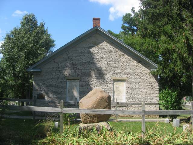
Photo: Wikimedia Commons contributor (own work), public domain · Wikimedia Commons
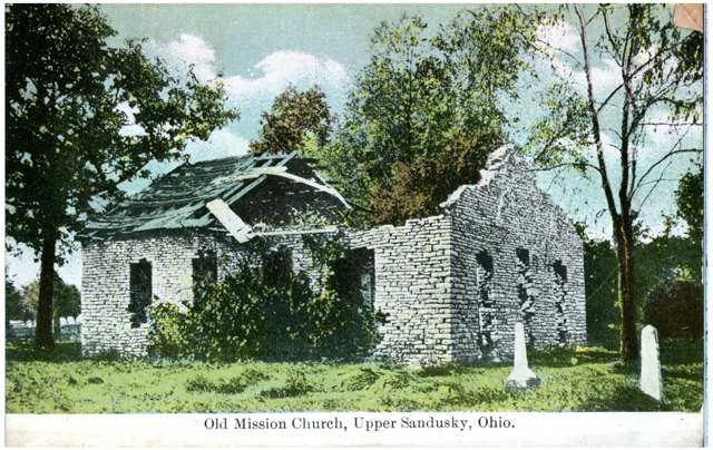
Photo: Columbus Metropolitan Library, via Digital Public Library of America / Ohio Digital Network, public domain · Wikimedia Commons
Local history sources: en.wikipedia.org · en.wikipedia.org · en.wikipedia.org · en.wikipedia.org · npgallery.nps.gov · aecom.com
Historic places
3 places in Upper Sandusky on the National Register of Historic Places. Press a pin or a name for its whole record.
-
Walker, William, Jr., HouseBuilding · Upper Sandusky · listed 1980
- Address
- 132--134 S. 4th St.
- Where
- Upper Sandusky, Wyandot County · ZIP 43351
- What it is
- Building
- Listed on the National Register
- 1980
- NRIS reference number
- 80003249
- Coordinates
- 40.82887, -83.27827
National Register file (NPS) ↗ Search Wikipedia ↗ Street map and directions ↗ On the Cracked Buckeye map
-
Wyandot County Courthouse and JailBuilding · Upper Sandusky · listed 1973
- Address
- Courthouse Sq.
- Where
- Upper Sandusky, Wyandot County · ZIP 43351
- What it is
- Building
- Listed on the National Register
- 1973
- NRIS reference number
- 73001553
- Coordinates
- 40.82143, -83.28062
National Register file (NPS) ↗ Search Wikipedia ↗ Street map and directions ↗ On the Cracked Buckeye map
-
Wyandot Mission ChurchBuilding · Upper Sandusky · listed 1976
- Address
- N of Upper Sandusky off Church St.
- Where
- Upper Sandusky, Wyandot County · ZIP 43351
- What it is
- Building
- Listed on the National Register
- 1976
- NRIS reference number
- 76001552
- Coordinates
- 40.83625, -83.27852
National Register file (NPS) ↗ Search Wikipedia ↗ Street map and directions ↗ On the Cracked Buckeye map
Source: National Park Service, National Register of Historic Places point file. The listing year is shown where NPS's certification date agrees with the listing's reference number. Listing recognizes significance; it does not restrict a private owner.
Water
Sandusky River, pumped to Upper Sandusky Reservoir #2 for storage. The CCR does not mention Reservoir 1, so it is not stated that water passes through both reservoirs. The water here
- Upper Sandusky City100% of residentsSandusky River (via Upper Sandusky Reservoirs 1 & 2)
Hospitals, fire stations and more
Inside Upper Sandusky's boundary: 1 hospital, 1 dialysis center, 1 nursing home, 1 fire or EMS station, 5 public schools, 1 private school, 1 library, 1 museum, 2 police stations, 2 public charging sites, 1 Superfund site, 13 Toxics Release Inventory facilities and 9 spill cases. Press a pin or a name for its whole record and its source.
Hospitals (1)
-
Wyandot Memorial HospitalGeneral hospital · Upper Sandusky
- What it is
- General hospital
- Address
- 885 N Sandusky Avenue, Upper Sandusky, OH 43351
- County
- Wyandot County
- Beds
- 25
- Helipad
- Yes
- Ownership
- Government - district/authority
- Medicare overall rating
- 5 of 5 stars
- Emergency department (Medicare)
- Yes
- Phone
- (419) 294-4991
- Medicare ID
- 361329
Medicare Care Compare ↗ Where HIFLD got this record ↗ HIFLD hospitals (source) ↗ Street map and directions ↗
Source: HIFLD hospitals inventory via FEMA (closed hospitals it still lists left out, hospitals opened since added), with Medicare Care Compare ratings matched by name and address.
Dialysis centers (1)
-
Wyandot Dialysis Clinic LlcDialysis · Upper Sandusky
- Address
- 1207 E. Wyandot Avenue, Upper Sandusky, OH 43351
- Dialysis stations
- 7
- Medicare star rating
- 1 of 5 stars
- Services
- in-center hemodialysis, peritoneal dialysis, home hemodialysis training
- Ownership
- for profit
- Chain
- independent
- Medicare certified since
- 2020-12-07
- Phone
- (419) 731-4056
- Medicare ID
- 362896
Medicare Care Compare ↗ CMS dialysis facility list (source) ↗ Street map and directions ↗
Source: CMS dialysis facility list, September 2026, geocoded with the Census Bureau batch geocoder (an address it could not place sits at its ZIP center).
Nursing homes (1)
-
Vancrest of Upper Sandusky4 of 5 stars · Upper Sandusky
- Address
- 850 Marseilles Avenue, Upper Sandusky, OH 43351
- Certified beds
- 99
- Residents on an average day
- 90
- Medicare overall rating
- 4 of 5 stars
- Health inspections
- 3 of 5 stars
- Staffing
- 3 of 5 stars
- Quality measures
- 5 of 5 stars
- Penalties since 2023
- none
- Ownership
- For profit - Limited Liability company
- Chain
- VANCREST HEALTH CARE CENTERS
- Takes
- Medicare and Medicaid
- Phone
- (419) 294-4973
- Medicare ID
- 365478
Medicare Care Compare ↗ CMS nursing home data (source) ↗ Street map and directions ↗
Source: CMS Care Compare nursing home provider and penalties files; Medicare star ratings run 1 to 5.
Fire and EMS stations (1)
-
Upper Sandusky Fire DepartmentUpper Sandusky
- Address
- 120 North 7th Street, Upper Sandusky, OH 43351
- Coordinates
- 40.82854, -83.28338
USGS National Map structures (source) ↗ Street map and directions ↗
Source: USGS National Map structures (most Ohio records last updated 2019 to 2022), checked against the Columbus and Cleveland station lists. The department that answers a call is set by jurisdiction and mutual aid, not by distance.
Public schools (5)
-
East Elementary School4.5 of 5 stars · Upper Sandusky
- Address
- 401 N 3rd St, Upper Sandusky, OH 43351
- School district
- Upper Sandusky Ex Vill School District
- Kind (NCES)
- Regular School
- Students, 2023-24
- 124
- Teachers (full-time equivalent)
- 8.2
- Report card, 2025-26
- 4.5 of 5 stars
- Performance index
- 95.3%
- Ohio building IRN
- 008946
- NCES school ID
- 391002404389
NCES school record ↗ Ohio School Report Card ↗ Street map and directions ↗
-
South Elementary School4.5 of 5 stars · Upper Sandusky
- Address
- 444 S 8th St, Upper Sandusky, OH 43351
- School district
- Upper Sandusky Ex Vill School District
- Kind (NCES)
- Regular School
- Students, 2023-24
- 135
- Teachers (full-time equivalent)
- 8.2
- Report card, 2025-26
- 4.5 of 5 stars
- Performance index
- 93%
- Ohio building IRN
- 033167
- NCES school ID
- 391002402310
NCES school record ↗ Ohio School Report Card ↗ Street map and directions ↗
-
Union Elementary School4.5 of 5 stars · Upper Sandusky
- Address
- 390 W Walker St, Upper Sandusky, OH 43351
- School district
- Upper Sandusky Ex Vill School District
- Kind (NCES)
- Regular School
- Students, 2023-24
- 246
- Teachers (full-time equivalent)
- 13.73
- Report card, 2025-26
- 4.5 of 5 stars
- Performance index
- 86.1%
- Ohio building IRN
- 022954
- NCES school ID
- 391002402308
NCES school record ↗ Ohio School Report Card ↗ Street map and directions ↗
-
Upper Sandusky High School3.5 of 5 stars · Upper Sandusky
- Address
- 800 N Sandusky Ave, Upper Sandusky, OH 43351
- School district
- Upper Sandusky Ex Vill School District
- Kind (NCES)
- Regular School
- Students, 2023-24
- 577
- Teachers (full-time equivalent)
- 29.78
- Report card, 2025-26
- 3.5 of 5 stars
- Performance index
- 81.4%
- Four-year graduation rate
- 94.1%
- Ohio building IRN
- 037952
- NCES school ID
- 391002402313
NCES school record ↗ Ohio School Report Card ↗ Street map and directions ↗
-
Upper Sandusky Middle School4 of 5 stars · Upper Sandusky
- Address
- 390 W Walker St, Upper Sandusky, OH 43351
- School district
- Upper Sandusky Ex Vill School District
- Kind (NCES)
- Regular School
- Students, 2023-24
- 509
- Teachers (full-time equivalent)
- 31.08
- Report card, 2025-26
- 4 of 5 stars
- Performance index
- 86%
- Ohio building IRN
- 066480
- NCES school ID
- 391002402311
NCES school record ↗ Ohio School Report Card ↗ Street map and directions ↗
Source: NCES EDGE public school locations 2024-25 and Common Core of Data 2023-24 (type, students, teachers); Ohio School Report Cards 2025-26 (Department of Education and Workforce), matched by name within the district.
Private schools (1)
-
St Peter SchoolPrivate, Catholic · Upper Sandusky
- Address
- 310 N 8Th St, Upper Sandusky, OH 43351
- Kind
- Catholic
- Students, 2023-24
- 148
- Teachers (full-time equivalent)
- 11.5
- Students per teacher
- 12.8696
- Phone
- (419) 294-1395
- NCES private school ID
- A1990616
Source: NCES Private School Survey 2023-24.
Public libraries (1)
-
Upper Sandusky Community LibraryCentral library · Upper Sandusky
- Address
- 301 N. Sandusky Ave., Upper Sandusky, OH 43351
- What it is
- Central library
- Library system
- Upper Sandusky Community Library
- Open
- 2,964 hours a year, 52 weeks
- Building
- 13,950 sq ft
- System's visits, FY2024
- 93,132
- System's loans, FY2024
- 112,493
- People the system serves
- 11,376
- Phone
- (419) 294-1345
IMLS Public Libraries Survey (source) ↗ Street map and directions ↗
Source: IMLS Public Libraries Survey FY2024 (outlets and their systems). Any Ohio resident can get a free card at any Ohio public library.
Museums, historical societies, gardens and zoos (1)
-
Wyandot County Historical SocietyHistorical society · Upper Sandusky
- What it is
- Historical society
- City
- Upper Sandusky
- Coordinates
- 40.82633, -83.28305
Search Wikipedia ↗ IMLS Museum Data Files (source) ↗ Street map and directions ↗
The museum list is IMLS's 2018 file; a museum may have closed or moved since.
Source: IMLS Museum Data Files, 2018.
Police stations (2)
-
Upper Sandusky Police DepartmentUpper Sandusky
- Address
- 120 North 7th Street, Upper Sandusky, OH 43351
- Coordinates
- 40.82842, -83.28342
USGS National Map structures (source) ↗ Street map and directions ↗
-
Wyandot County Sheriff's OfficeUpper Sandusky
- Address
- 125 East Wyandot Avenue, Upper Sandusky, OH 43351
- Coordinates
- 40.82717, -83.28015
USGS National Map structures (source) ↗ Street map and directions ↗
Source: USGS National Map structures, police stations, corrected and completed by hand (September 2026). The department that answers a call is set by jurisdiction, not by distance.
Public EV charging (2)
-
Arby's - Tesla Supercharger DC fast12 DC fast · Upper Sandusky
- Address
- 1745 E Wyandot Ave, Upper Sandusky, OH 43351
- Ports
- 12 DC fast
- Plugs
- Tesla (NACS)
- Network
- Tesla
- Hours
- 24 hours daily. Please check Tesla's online station map to see if an adapter is required at this location.
- Phone
- 877-798-3752
Station Locator (NREL) ↗ Alternative Fuels Data Center (source) ↗ Street map and directions ↗
-
UPPERSANDCHARGE UPPER SANDUSKY DC fast1 DC fast · Upper Sandusky
- Address
- 119 N 7th St, Upper Sandusky, OH 43351
- Ports
- 1 DC fast
- Plugs
- CCS, CHAdeMO
- Network
- ChargePoint Network
- Hours
- 24 hours daily
- Phone
- 888-758-4389
Station Locator (NREL) ↗ Alternative Fuels Data Center (source) ↗ Street map and directions ↗
Source: NREL Alternative Fuels Data Center station list (May 2026), public and open stations, the posts at one address counted as one site.
Superfund sites (1)
-
Sandusky Residential Hg SpillSuperfund program · Upper Sandusky
- Address
- 335 West Walker Street, Upper Sandusky, OH 43351
- County
- Wyandot County
- Status
- Superfund program site, not on the National Priorities List
- EPA program ID
- OHN000509015
- EPA registry ID
- 110015777907
EPA facility record ↗ EPA Facility Registry Service (source) ↗ Street map and directions ↗
Source: EPA Facility Registry Service, Superfund (SEMS) and National Priorities List sites. Many program sites were assessed and needed no cleanup.
Facilities reporting toxic releases (13)
-
A. O. Smith Electrical Products Co.Toxics Release Inventory · Upper Sandusky
- Address
- 750 W. Spring St., Upper Sandusky, OH 43351
- County
- Wyandot County
- Status
- Reports to the Toxics Release Inventory (active)
- EPA program ID
- 43351SMTHL750WS
- EPA registry ID
- 110000383086
EPA facility record ↗ EPA Facility Registry Service (source) ↗ Street map and directions ↗
-
Archem America, Inc. (0388010051)Toxics Release Inventory · Upper Sandusky
- Address
- 245 Commerce Way, Upper Sandusky, OH 43351
- County
- Wyandot County
- Status
- Reports to the Toxics Release Inventory (active)
- EPA program ID
- 43351BRDGS245CO
- EPA registry ID
- 110066942447
EPA facility record ↗ EPA Facility Registry Service (source) ↗ Street map and directions ↗
-
Blackhawk Automotive PlasticsToxics Release Inventory · Upper Sandusky
- Address
- 500 North Warpole Street, Upper Sandusky, OH 43351
- County
- Wyandot County
- Status
- Reports to the Toxics Release Inventory (active)
- EPA program ID
- 43351MLLNG500NW
- EPA registry ID
- 110000383077
EPA facility record ↗ EPA Facility Registry Service (source) ↗ Street map and directions ↗
-
Bridgestone Apm Co Upper Sandusky Avd Plt 2Toxics Release Inventory · Upper Sandusky
- Address
- 235 Commerce Way, Upper Sandusky, OH 43351
- County
- Wyandot County
- Status
- Reports to the Toxics Release Inventory (***unchanged***)
- EPA program ID
- 4335WBRDGS235CM
- EPA registry ID
- 110044246045
EPA facility record ↗ EPA Facility Registry Service (source) ↗ Street map and directions ↗
-
Custom Glass Solutions Upper Sandusky LlcToxics Release Inventory · Upper Sandusky
- Address
- 12688 State Route 67 South, Upper Sandusky, OH 43351
- County
- Wyandot County
- Status
- Reports to the Toxics Release Inventory (open)
- EPA program ID
- 43351GRDNTRR5ST
- EPA registry ID
- 110000840591
EPA facility record ↗ EPA Facility Registry Service (source) ↗ Street map and directions ↗
-
Defiance Precision ProdsToxics Release Inventory · Upper Sandusky
- Address
- 250 Commerce Way, Upper Sandusky, OH 43351
- County
- Wyandot County
- Status
- Reports to the Toxics Release Inventory (active)
- EPA program ID
- 43351DFNCP250CO
- EPA registry ID
- 110000383068
EPA facility record ↗ EPA Facility Registry Service (source) ↗ Street map and directions ↗
-
Dlubak GlassToxics Release Inventory · Upper Sandusky
- Address
- 500 Raybestos Dr, Upper Sandusky, OH 43351
- County
- Wyandot County
- Status
- Reports to the Toxics Release Inventory (active)
- EPA program ID
- 43351CNTNN7854S
- EPA registry ID
- 110064190101
EPA facility record ↗ EPA Facility Registry Service (source) ↗ Street map and directions ↗
-
M-Tek IncToxics Release Inventory · Upper Sandusky
- Address
- 1111 N Warpole St, Upper Sandusky, OH 43351
- County
- Wyandot County
- Status
- Reports to the Toxics Release Inventory (active)
- EPA program ID
- 43351MTKNC1111N
- EPA registry ID
- 110004735715
EPA facility record ↗ EPA Facility Registry Service (source) ↗ Street map and directions ↗
-
Mills CoToxics Release Inventory · Upper Sandusky
- Address
- 112 River St, Upper Sandusky, OH 43351
- County
- Wyandot County
- Status
- Reports to the Toxics Release Inventory (active)
- EPA program ID
- 43351MLLSC112RI
- EPA registry ID
- 110004591166
EPA facility record ↗ EPA Facility Registry Service (source) ↗ Street map and directions ↗
-
Mills Co.Toxics Release Inventory · Upper Sandusky
- Address
- 11500 River St., Upper Sandusky, OH 43351
- County
- Wyandot County
- Status
- Reports to the Toxics Release Inventory (active)
- EPA program ID
- 43351MLLSC11500
- EPA registry ID
- 110002109520
EPA facility record ↗ EPA Facility Registry Service (source) ↗ Street map and directions ↗
-
Prospira America Corporation (0388010047)Toxics Release Inventory · Upper Sandusky
- Address
- 235 Commerce Way, Upper Sandusky, OH 43351
- County
- Wyandot County
- Status
- Reports to the Toxics Release Inventory (active)
- EPA program ID
- 43351BRDGS235CO
- EPA registry ID
- 110069348682
EPA facility record ↗ EPA Facility Registry Service (source) ↗ Street map and directions ↗
-
Todco, Division of Overhead Door CorporationToxics Release Inventory · Upper Sandusky
- Address
- 781 Route 30 West, Upper Sandusky, OH 43351
- County
- Wyandot County
- Status
- Reports to the Toxics Release Inventory (active)
- EPA program ID
- 43351VRHDD781RT
- EPA registry ID
- 110000815388
EPA facility record ↗ EPA Facility Registry Service (source) ↗ Street map and directions ↗
-
Tower Automotive Prods IncToxics Release Inventory · Upper Sandusky
- Address
- 9841 County Hwy. 49, Upper Sandusky, OH 43351
- County
- Wyandot County
- Status
- Reports to the Toxics Release Inventory (active)
- EPA program ID
- 43351TWRTM9841C
- EPA registry ID
- 110006106338
EPA facility record ↗ EPA Facility Registry Service (source) ↗ Street map and directions ↗
Source: EPA Facility Registry Service, Toxics Release Inventory reporters. Reporting a release is required of large users of listed chemicals; it is not by itself a violation.
Spills reported since 2021 (9)
-
Acid Nos (Not Specified)2025-09-18 · Upper Sandusky
- Reported
- 2025-09-18
- What spilled
- Acid Nos (Not Specified)
- Where
- Upper Sandusky, Wyandot County
- Ohio EPA district office
- NWDO
- Ohio EPA case number
- 2509EPA0001564
Ohio EPA spill reports (source) ↗ Street map and directions ↗
-
Hydrogen Peroxide (H2O2)2024-06-17 · Upper Sandusky
- Reported
- 2024-06-17
- What spilled
- Hydrogen Peroxide (H2O2)
- Largest amount reported
- 55 gallons
- Where
- Upper Sandusky, Wyandot County
- Ohio EPA district office
- NWDO
- Ohio EPA case number
- 2406EPA0001041
Ohio EPA spill reports (source) ↗ Street map and directions ↗
-
Fuel Diesel / Diesel Fuel (Vehicle On Or Off Road)2024-02-24 · Upper Sandusky
- Reported
- 2024-02-24
- What spilled
- Fuel Diesel / Diesel Fuel (Vehicle On Or Off Road)
- Largest amount reported
- 50 gallons
- Where
- Upper Sandusky, Wyandot County
- Ohio EPA district office
- NWDO
- Ohio EPA case number
- 2402EPA0000289
Ohio EPA spill reports (source) ↗ Street map and directions ↗
-
Fuel Diesel / Diesel Fuel (Vehicle On Or Off Road)2024-02-17 · Upper Sandusky
- Reported
- 2024-02-17
- What spilled
- Fuel Diesel / Diesel Fuel (Vehicle On Or Off Road)
- Largest amount reported
- 90 gallons
- Where
- Upper Sandusky, Wyandot County
- Ohio EPA district office
- NWDO
- Ohio EPA case number
- 2402EPA0000257
Ohio EPA spill reports (source) ↗ Street map and directions ↗
-
Oil Transformer Non Pcb2023-04-01 · Upper Sandusky
- Reported
- 2023-04-01
- What spilled
- Oil Transformer Non Pcb
- Largest amount reported
- 80 gallons
- Where
- Upper Sandusky, Wyandot County
- Ohio EPA district office
- NWDO
- Ohio EPA case number
- 2304EPA0000492
Ohio EPA spill reports (source) ↗ Street map and directions ↗
-
Fuel Diesel / Diesel Fuel (Vehicle On Or Off Road) Reached water2022-09-27 · Upper Sandusky
- Reported
- 2022-09-27
- What spilled
- Fuel Diesel / Diesel Fuel (Vehicle On Or Off Road)
- Reached a waterway
- 99 - Unnamed
- Where
- Upper Sandusky, Wyandot County
- Ohio EPA district office
- NWDO
- Ohio EPA case number
- 2209EPA0001478
Ohio EPA spill reports (source) ↗ Street map and directions ↗
-
Fertilizer(S) Nos (Not Specified)2021-05-06 · Upper Sandusky
- Reported
- 2021-05-06
- What spilled
- Fertilizer(S) Nos (Not Specified)
- Where
- Upper Sandusky, Wyandot County
- Ohio EPA district office
- NWDO
- Ohio EPA case number
- 2105EPA0000633
Ohio EPA spill reports (source) ↗ Street map and directions ↗
-
Fuel Diesel / Diesel Fuel (Vehicle On Or Off Road)2026-04-28 · Upper Sandusky
- Reported
- 2026-04-28
- What spilled
- Fuel Diesel / Diesel Fuel (Vehicle On Or Off Road)
- Largest amount reported
- 400 gallons
- Where
- Upper Sandusky, Wyandot County
- Ohio EPA district office
- NWDO
- Ohio EPA case number
- 2604EPA0000705
Ohio EPA spill reports (source) ↗ Street map and directions ↗
-
Oil Transformer Non Pcb2026-03-11 · Upper Sandusky
- Reported
- 2026-03-11
- What spilled
- Oil Transformer Non Pcb
- Where
- Upper Sandusky, Wyandot County
- Ohio EPA district office
- NWDO
- Ohio EPA case number
- 2603EPA0000354
Ohio EPA spill reports (source) ↗ Street map and directions ↗
Source: Ohio EPA emergency response spill reports, 2021 to September 2026, one point per case where Ohio EPA placed it. A report is what the caller or responder recorded; amounts are often blank or estimated.
Its ZIP codes
Each ZIP code that touches Upper Sandusky, with the share of its residents who live here and the same headline figures as the ZIP page.
| ZIP | Share | Water | Radon | Home value | Schools | Flood |
|---|---|---|---|---|---|---|
| 43351 Upper Sandusky | 66% | Sandusky River, pumped to Upper Sandusky Reservoir #2 for storage. The CCR does not mention Reservoir 1, so it is not stated that water passes through both reservoirs. | 6.7 pCi/L average radon | Appraisal records without year built | Upper Sandusky Exempted Village · 4 stars overall | No digital FEMA flood map for this county |
Local government
Who holds office in Upper Sandusky, how its elections and ballot issues came out, and the state auditor's record.
Money issues on the ballot since 2022: 1 of 1 passed.
Ballot issues
| Date | Issue | For | Against | Result |
|---|---|---|---|---|
| 2025-05-06 | Issue: Upper Sandusky Income Tax | 465 | 486 | Failed (48.9% for), unofficial |
| 2022-11-08 | Issue: City of Upper Sandusky Charter Amendment | 1,374 | 830 | Passed (62.34% for) |
| 2022-05-03 | Issue: City of Upper Sandusky Tax Levy | 666 | 345 | Passed (65.88% for) |
| 2021-11-02 | Issue: City of Upper Sandusky Electric Aggregation | 651 | 390 | Passed (62.54% for) |
| 2021-11-02 | Issue: City of Upper Sandusky Gas Aggregation | 646 | 379 | Passed (63.02% for) |
Elections for office
| Date | Office | Candidates and votes |
|---|---|---|
| 2023-11-07 | Member of Council at Large (unofficial count) | Julia Lemire (REP) 1,214, 31.34%; Scott Moore 1,186, 30.61%; Katherine P. Niederkohr (REP) 1,474, 38.05% |
| 2023-11-07 | Mayor (unofficial count) | Mark A. Albert 691, 33.25%; Kyle McColly (REP) 1,387, 66.75% |
| 2021-11-02 | Member of Council at Large | Tom Karcher (REP) 754, 26.24%; Aaron Korte (REP) 729, 25.37%; Ken Wessler (REP) 709, 24.68%; John M. Walker (REP) 681, 23.7% |
Winners in bold. Results from the county board of elections' official canvass unless marked.
Auditor of State record
- No fiscal caution, watch or emergency on the Auditor of State's lists.
- Financial Health Indicators (the Auditor of State's 17 measures; critical / cautionary / positive): 2017 6 / 2 / 9; 2018 6 / 3 / 8; 2019 1 / 5 / 11; 2020 1 / 3 / 13; 2021 1 / 2 / 14; 2022 1 / 4 / 12.
- Financial Audit, 2023 to 2024, released 2025-12-16
The county
Wyandot County: 8 ZIP codes, 22 cities, villages and townships, 23,021 people.
Nearby places
Rain and snow
How much has actually fallen on Upper Sandusky, day by day, from 1892 to now. Daily totals, not averages.
- rain, last 30 days
- 1.12 in
- 2026-09-30 to 2026-10-29
- rain so far in 2026
- 35.5 in
- about normal for the date
- snow so far in 2026
- 17.9 in
- a normal year brings 27.4 in
- a normal year
- 39.8 in
- average of 30 years, 1991-2020
| Month | Rain (in) | Snow (in) | Days counted |
|---|---|---|---|
| October 2026 | 1.12 | — | 29 |
| September 2026 | 4.74 | — | 30 |
| August 2026 | 5.20 | — | 31 |
| July 2026 | 2.72 | — | 31 |
| June 2026 | 4.26 | — | 30 |
| May 2026 | 5.26 | — | 31 |
| April 2026 | 6.34 | — | 30 |
| March 2026 | 4.11 | 0.4 | 31 |
| February 2026 | 0.52 | 3.6 | 28 |
| January 2026 | 1.27 | 13.8 | 31 |
| December 2025 | 2.06 | 8.8 | 31 |
| November 2025 | 1.43 | 1.7 | 30 |
| Wettest year | 2011 — 59.5 in |
|---|---|
| Driest year | 1963 — 22.4 in |
| Snowiest year | 1910 — 71.8 in |
| Wettest day on record | 21 August 2007 — 9.35 in |
| Heaviest snowfall in a day | 23 December 2004 — 13.89 in |
| Deepest snow on the ground | 23 February 1914 — 24.02 in |
84% of these days are measurements from a gauge inside Upper Sandusky; the rest are estimated from the nearest gauges around it.
48,836 days of records, 1892-12-01 to 2026-10-29. Source: NOAA NCEI GHCN-Daily, 3,240 gauges in and around Ohio. A day is "gauged" when a gauge standing inside the boundary reported it, and the value is the mean of those gauges. Otherwise it is interpolated by inverse distance from every gauge reporting within 50 miles. Nothing is carried forward, back-filled or smoothed. Against NOAA nClimDiv county monthly precipitation over 136,848 complete county-months (checked 2026-10-31): correlation 0.9515, median absolute difference 0.217 in a month. Built 2026-10-31 from the Cracked Buckeye precipitation archive. Snow is the softer number — snowfall is measured by hand with a ruler, no agency publishes a gridded county snowfall series, and blowing snow defeats every observer.
Environmental permits and filings
What Ohio EPA has on file for Upper Sandusky: permits, inspections, violations, cleanups and the state loans behind sewer and water work. Every line links to the agency's own document.
- facilities and sites on file
- 37
- those placed on the map inside Upper Sandusky
| Program | Facilities and sites |
|---|---|
| Hazardous waste | 12 |
| Air pollution | 11 |
| State sewer loans | 4 |
| State water loans | 3 |
| Public drinking water | 2 |
| Wastewater and stormwater discharge | 2 |
| Composting | 1 |
| Landfills | 1 |
| Sewer and water-line construction | 1 |
| Date | Facility or site | What |
|---|---|---|
| PROSPIRA AMERICA CORPORATION | Air pollution inspection | |
| UPPER SANDUSKY WWTP | Wastewater and stormwater discharge permit | |
| UPPER SANDUSKY CITY PWS | Public drinking water compliance letter | |
| UPPER SANDUSKY CITY PWS | Public drinking water compliance letter | |
| ARCHEM AMERICA INC | Air pollution notice of violation | |
| ARCHEM AMERICA INC | Air pollution violation resolved | |
| UPPER SANDUSKY CITY PWS | Public drinking water plan | |
| ARCHEM AMERICA INC | Air pollution permit | |
| PROSPIRA AMERICA CORPORATION | Air pollution permit | |
| PROSPIRA AMERICA CORPORATION | Air pollution inspection | |
| ARCHEM AMERICA INC | Air pollution permit | |
| PROSPIRA AMERICA CORPORATION | Air pollution permit | |
| UPPER SANDUSKY CITY PWS | Public drinking water report | |
| XPO LOGISTICS FREIGHT INC XFM | Air pollution report | |
| ARCHEM AMERICA INC | Air pollution permit | |
| PROSPIRA AMERICA CORPORATION | Air pollution permit | |
| UPPER SANDUSKY CITY PWS | Public drinking water plan | |
| UPPER SANDUSKY CITY PWS | Public drinking water plan | |
| UPPER SANDUSKY CITY PWS | Public drinking water plan | |
| UPPER SANDUSKY CITY PWS | Public drinking water inspection | |
| UPPER SANDUSKY CITY PWS | Public drinking water plan | |
| UPPER SANDUSKY CITY PWS | Public drinking water inspection | |
| UPPER SANDUSKY CITY PWS | Public drinking water inspection | |
| UPPER SANDUSKY WWTP | Wastewater and stormwater discharge plan | |
| UPPER SANDUSKY WWTP | Wastewater and stormwater discharge permit |
Source: Ohio EPA eDocument portal (edocpub.epa.ohio.gov), indexed 2026-10-14. Facilities are placed on the map from Ohio EPA's own map layers, EPA's Facility Registry, coordinates written in the filings, or a geocoded street address. A permit filed under a private person's name (most are household septic systems) is counted but never named, placed or linked; licenses for individual workers and open-burning notices are left out entirely.
Quick answers
What county is Upper Sandusky, Ohio in?
Upper Sandusky is a city in Wyandot County, Ohio, with 6,649 residents.
When was Upper Sandusky, Ohio founded?
Upper Sandusky was settled 1843; laid out 1843; incorporated 1848 (sources are unclear whether this is the year of incorporation or of becoming county seat). Founders on record: settlers following the 1843 Wyandot removal; laid out near the site of the former Wyandot town and reservation. Source
How did Upper Sandusky, Ohio get its name?
The city takes its name from an earlier Wyandot town on the same site, itself named for its location near the headwaters (the 'upper' reaches) of the Sandusky River, which flows north to Lake Erie at the city of Sandusky. Source
What ZIP code is Upper Sandusky, Ohio?
Most of Upper Sandusky is in ZIP code 43351.
Where does Upper Sandusky, Ohio get its water?
The main water source for Upper Sandusky (Upper Sandusky City): Sandusky River, pumped to Upper Sandusky Reservoir #2 for storage. The CCR does not mention Reservoir 1, so it is not stated that water passes through both reservoirs.
Cite this page
Cite this page as:
Cracked Buckeye, "Upper Sandusky, Wyandot County", https://crackedbuckeye.com/place/upper-sandusky/, built 2026-10-31, accessed [date].
How to cite · Report a correction · Built 2026-10-31
