Local events in Crane Township, Wyandot County
Nothing is posted for Crane Township itself yet; here is what is on within 20 miles. All local events in Crane Township, Wyandot County
Know a calendar we should watch? Send the link
Checked October 20; the events page is refreshed daily.
How Crane Township, Wyandot County began
Crane Township, at the center of Wyandot County, takes its name from the Wyandot (Huron) chief Tarhe, 'The Crane,' and lay wholly inside the Wyandot Reserve, so its land was not offered for sale until autumn 1845. It holds the 'Indian Mill' the U.S. government built for the Wyandots in 1820 on the Sandusky River, the Wyandot mission church just north of Upper Sandusky, and the Parker Covered Bridge of 1873. The township was organized as now constituted in 1845, the year Wyandot County was formed; Upper Sandusky, the county seat, was incorporated within it in 1848. It had 1,487 residents outside the town in 1880.
Settled before 1845 (squatters on the Wyandot Reserve; the Wyandot nation lived here until 1843), incorporated 1845 (organized as now constituted), by Wyandot County's first commissioners, on the former Wyandot Reserve.
Where the name comes from
The township 'derives its name from the Wyandot Chieftain, Tarhe, or The Crane,' says the 1884 county history. Tarhe (about 1742-1818) signed the Treaty of Greenville and the later treaties of the War of 1812, and the Crane Town where he lived and died lay about four miles northeast of present Upper Sandusky.
Before the town
Crane Township was the heart of the Wyandot reservation. The county history says the Indian town called Upper Sandusky was originally about four miles northeast of the present county seat; after the death of Tarhe (1818) the Wyandots built a council house on the site of the present town, which lay nearer the center of their reservation, called it Upper Sandusky, and renamed the old village Crane Town. The old council house, about a mile and a half north of Crane Town, was a bark building roughly 100 feet by 15. Under the treaty of September 29, 1817 at the Maumee Rapids the United States agreed to build the Wyandots a saw and grist mill, which it did in 1820 about three miles northeast of Upper Sandusky on the Sandusky River (the Indian Mill); Wyandot flour, corn meal and lumber came from it until the nation left for Kansas. The Methodist missionaries John Stewart and James B. Finley built a mission house in 1821 and, in 1824, the stone mission church just north of town. Near Crawford's Battle Ground on Section 17, local tradition places the Nine Oaks where an Indian court that tried Col. William Crawford in 1782 is said to have met. The Wyandots left Upper Sandusky for the West in 1843; their lands were then surveyed and sold from autumn 1845.
Nations recorded here: Wyandot, Lenape (Delaware).
- Crane Town (Tarhetown) (village) — about four miles northeast of present Upper Sandusky, Crane Township, to 1818 and after (archive.org)
- Indian Mill (government mill for the Wyandot) (other) — about 3.5 miles northeast of Upper Sandusky on the Sandusky River, built 1820; used until 1843 (archive.org)
- Wyandot Mission Church (other) — north side of Upper Sandusky, off Church Street, 1824-1843 and later (en.wikipedia.org)
- Nine Oaks, traditional meeting place of the Indian court on Col. Crawford (other) — near Crawford's Battle Ground, Section 17, Crane Township, 1782 (tradition) (archive.org)
Timeline
- — The Treaty of Greenville, signed among others by Tarhe (The Crane), ends the Northwest Indian War.
- — On September 29 the Treaty of the Maumee Rapids (Fort Meigs) promises the Wyandots a perpetual annuity of $4,000 and a government-built saw and grist mill on the Sandusky.
- — Tarhe dies at Crane Town; the Wyandots then build a council house on the site of Upper Sandusky and rename the old village Crane Town.
- — The government builds the saw and grist mill for the Wyandots, about three miles northeast of Upper Sandusky on the Sandusky River; the missionaries use its saw mill for lumber in 1821.
- — Finley's Methodist mission builds the blue limestone Wyandot Mission Church on the north edge of Upper Sandusky, the first mission church of the Methodist Episcopal Church.
- — The Wyandot nation leaves Upper Sandusky for Kansas; in July they meet at the mission church for a farewell and deed it to the Methodist Church.
- — Wyandot County is formed and Crane Township is organized as now constituted; the reserve lands outside the old town plat are put on sale that autumn.
- — The legislature incorporates Upper Sandusky as a town, taking the recorded town plat out of Crane Township.
- — A new mill is built about twenty rods north of the old Indian Mill (the county history says about twenty-two years before 1884); the old burrs and bolting chest remain in use.
- — J. C. Davis builds the Parker Covered Bridge, a Howe truss about 172 feet long, on what is now Township Road 40A, five miles northeast of Upper Sandusky.
- — The township has 1,487 residents outside the corporate limits of Upper Sandusky.
- — The Indian Mill is listed on the National Register of Historic Places on November 10.
- — The Parker Covered Bridge is listed on the National Register on March 31; a fire damages it on May 17, 1991 and it is restored in 1993.
- — The Armstrong Farm, 13706 State Route 199, is listed on the National Register on January 17.
Stories
The mill the government built for the Wyandots
By the treaty signed at the Maumee Rapids on September 29, 1817, the United States agreed to build a saw and grist mill and to keep two blacksmiths for the Wyandots. The mills were built in 1820 about three miles northeast of Upper Sandusky on the Sandusky River, and the missionaries hauled logs to them the next year to saw the planks for the mission house floor. For more than twenty years the mill supplied the Wyandots with flour, corn meal and lumber, until the nation moved to Kansas in 1843. After the land was sold in 1845 the mill went on grinding; a new mill was built about 1862 twenty rods north of the old one, and the county historian noted that the old buhrs and bolting chest were still in use in it. The surviving Indian Mill was listed on the National Register of Historic Places in 1970.
Crane Town and the naming of Upper Sandusky
The Wyandot chief Tarhe, 'The Crane,' signed the Treaty of Greenville and the treaties of the War of 1812 and lived at a village on the Sandusky about four miles northeast of the present county seat of Upper Sandusky. When he died in 1818 the nation built a council house on a spot nearer the center of its twelve-mile-square reservation and gave it the name Upper Sandusky, and the old village became Crane Town. The old council house, a bark building about a hundred feet long and fifteen feet wide, stood about a mile and a half north of Crane Town; the new site soon had a more substantial frame council house, later used as the Wyandot County courthouse. The township organized in 1845 on the old reservation took the chief's name.
Photographs
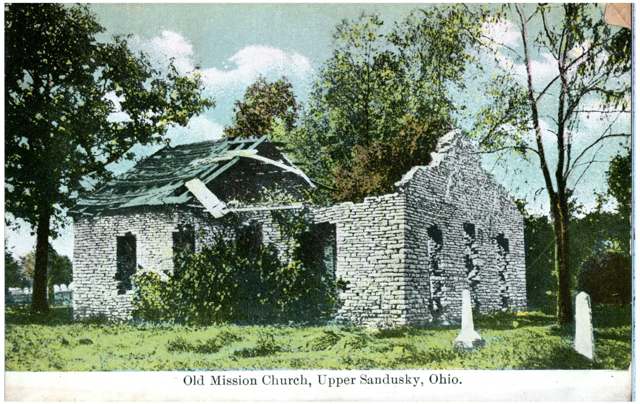
Photo: Columbus Metropolitan Library, via Digital Public Library of America / Ohio Digital Network, public domain · Wikimedia Commons
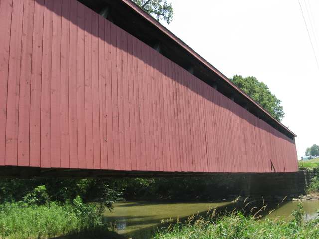
Photo: Nyttend, public domain · Wikimedia Commons
Local history sources: en.wikipedia.org · en.wikipedia.org · en.wikipedia.org · en.wikipedia.org · archive.org · commons.wikimedia.org · commons.wikimedia.org
Historic places
2 places in Crane Township, Wyandot County on the National Register of Historic Places. Press a pin or a name for its whole record.
-
Indian MillBuilding · Upper Sandusky · listed 1970
- Address
- 3.5 mi. NE of Upper Sandusky on Crane Twnshp. Rd.
- Where
- Upper Sandusky, Wyandot County · ZIP 43351
- What it is
- Building
- Listed on the National Register
- 1970
- NRIS reference number
- 70000525
- Coordinates
- 40.86339, -83.25430
National Register file (NPS) ↗ Search Wikipedia ↗ Street map and directions ↗ On the Cracked Buckeye map
-
Parker Covered BridgeStructure · Upper Sandusky · listed 1975
- Address
- 5 mi. NE of Upper Sandusky on SR 40A
- Where
- Upper Sandusky, Wyandot County · ZIP 43351
- What it is
- Structure
- Listed on the National Register
- 1975
- NRIS reference number
- 75001558
- Coordinates
- 40.90321, -83.24461
National Register file (NPS) ↗ Search Wikipedia ↗ Street map and directions ↗ On the Cracked Buckeye map
Source: National Park Service, National Register of Historic Places point file. The listing year is shown where NPS's certification date agrees with the listing's reference number. Listing recognizes significance; it does not restrict a private owner.
Water
Sandusky River, pumped to Upper Sandusky Reservoir #2 for storage. The CCR does not mention Reservoir 1, so it is not stated that water passes through both reservoirs. The water here
- Upper Sandusky City100% of residentsSandusky River (via Upper Sandusky Reservoirs 1 & 2)
Hospitals, fire stations and more
Inside Crane Township, Wyandot County's boundary: 1 Toxics Release Inventory facility and 5 spill cases. Press a pin or a name for its whole record and its source.
Facilities reporting toxic releases (1)
-
Dlubak Glass CoToxics Release Inventory · Upper Sandusky
- Address
- 11567 Co Hwy 110, Upper Sandusky, OH 43351
- County
- Wyandot County
- Status
- Reports to the Toxics Release Inventory
- EPA program ID
- TRI_OFFSITE_625
- EPA registry ID
- 110006104447
EPA facility record ↗ EPA Facility Registry Service (source) ↗ Street map and directions ↗
Source: EPA Facility Registry Service, Toxics Release Inventory reporters. Reporting a release is required of large users of listed chemicals; it is not by itself a violation.
Spills reported since 2021 (5)
-
Fuel Diesel / Diesel Fuel (Vehicle On Or Off Road)2025-12-14 · Crane Twp
- Reported
- 2025-12-14
- What spilled
- Fuel Diesel / Diesel Fuel (Vehicle On Or Off Road)
- Largest amount reported
- 100 gallons
- Where
- Crane Twp, Wyandot County
- Ohio EPA district office
- NWDO
- Ohio EPA case number
- 2512EPA0001996
Ohio EPA spill reports (source) ↗ Street map and directions ↗
-
Fuel Diesel / Diesel Fuel (Vehicle On Or Off Road)2025-06-27 · Crane Twp
- Reported
- 2025-06-27
- What spilled
- Fuel Diesel / Diesel Fuel (Vehicle On Or Off Road)
- Largest amount reported
- 300 gallons
- Where
- Crane Twp, Wyandot County
- Ohio EPA district office
- NWDO
- Ohio EPA case number
- 2506EPA0001072
Ohio EPA spill reports (source) ↗ Street map and directions ↗
-
Fuel Diesel / Diesel Fuel (Vehicle On Or Off Road)2022-05-17 · Crane Twp
- Reported
- 2022-05-17
- What spilled
- Fuel Diesel / Diesel Fuel (Vehicle On Or Off Road)
- Largest amount reported
- 40 gallons
- Where
- Crane Twp, Wyandot County
- Ohio EPA district office
- NWDO
- Ohio EPA case number
- 2205EPA0000721
Ohio EPA spill reports (source) ↗ Street map and directions ↗
-
Fuel Diesel / Diesel Fuel (Vehicle On Or Off Road)2021-01-06 · Crane Twp
- Reported
- 2021-01-06
- What spilled
- Fuel Diesel / Diesel Fuel (Vehicle On Or Off Road)
- Largest amount reported
- 80 gallons
- Where
- Crane Twp, Seneca County
- Ohio EPA district office
- NWDO
- Ohio EPA case number
- 2108EPA0001354
Ohio EPA spill reports (source) ↗ Street map and directions ↗
-
Fuel Diesel / Diesel Fuel (Vehicle On Or Off Road)2026-04-01 · Crane Twp
- Reported
- 2026-04-01
- What spilled
- Fuel Diesel / Diesel Fuel (Vehicle On Or Off Road)
- Where
- Crane Twp, Wyandot County
- Ohio EPA district office
- NWDO
- Ohio EPA case number
- 2604EPA0000543
Ohio EPA spill reports (source) ↗ Street map and directions ↗
Source: Ohio EPA emergency response spill reports, 2021 to September 2026, one point per case where Ohio EPA placed it. A report is what the caller or responder recorded; amounts are often blank or estimated.
Its ZIP codes
Each ZIP code that touches Crane Township, Wyandot County, with the share of its residents who live here and the same headline figures as the ZIP page.
| ZIP | Share | Water | Radon | Home value | Schools | Flood |
|---|---|---|---|---|---|---|
| 43351 Upper Sandusky | 9% | Sandusky River, pumped to Upper Sandusky Reservoir #2 for storage. The CCR does not mention Reservoir 1, so it is not stated that water passes through both reservoirs. | 6.7 pCi/L average radon | Appraisal records without year built | Upper Sandusky Exempted Village · 4 stars overall | No digital FEMA flood map for this county |
Local government
Who holds office in Crane Township, Wyandot County, how its elections and ballot issues came out, and the state auditor's record.
Money issues on the ballot since 2022: 1 of 1 passed.
Ballot issues
| Date | Issue | For | Against | Result |
|---|---|---|---|---|
| 2022-11-08 | Issue: Crane Township Tax Levy | 1,684 | 960 | Passed (63.69% for) |
Elections for office
| Date | Office | Candidates and votes |
|---|---|---|
| 2023-11-07 | Township Trustee (unofficial count) | Dylan Britton 791, 35.39%; Mark A. Waiton 1,444, 64.61% |
| 2023-11-07 | Township Fiscal Officer (unofficial count) | Debbie Bastel 2,115, 100.0% |
| 2021-11-02 | Township Trustee | Alan Courtright 879, 44.17%; Stephen C. Swihart, Jr. 633, 31.81%; James S.Barney 478, 24.02% |
Winners in bold. Results from the county board of elections' official canvass unless marked.
Auditor of State record
- No fiscal caution, watch or emergency on the Auditor of State's lists.
- Agreed Upon Procedures, 2023 to 2024, released 2025-07-10
The county
Wyandot County: 8 ZIP codes, 22 cities, villages and townships, 23,021 people.
Nearby places
Quick answers
What county is Crane Township, Ohio in?
Crane Township, Wyandot County is a township in Wyandot County, Ohio, with 896 residents.
When was Crane Township, Ohio founded?
Crane Township, Wyandot County was settled before 1845 (squatters on the Wyandot Reserve; the Wyandot nation lived here until 1843); incorporated 1845 (organized as now constituted). Founders on record: Wyandot County's first commissioners, on the former Wyandot Reserve. Source
How did Crane Township, Ohio get its name?
The township 'derives its name from the Wyandot Chieftain, Tarhe, or The Crane,' says the 1884 county history. Source
What ZIP code is Crane Township, Ohio?
Most of Crane Township, Wyandot County is in ZIP code 43351.
Where does Crane Township, Ohio get its water?
The main water source for Crane Township, Wyandot County (Upper Sandusky City): Sandusky River, pumped to Upper Sandusky Reservoir #2 for storage. The CCR does not mention Reservoir 1, so it is not stated that water passes through both reservoirs.
Cite this page
Cite this page as:
Cracked Buckeye, "Crane Township, Wyandot County", https://crackedbuckeye.com/place/crane-township-wyandot-county/, built 2026-10-31, accessed [date].
How to cite · Report a correction · Built 2026-10-31
