Water system
Upper Sandusky City
EPA ID OH8800511 · Wyandot County · 6,698 people served · owned by a local government
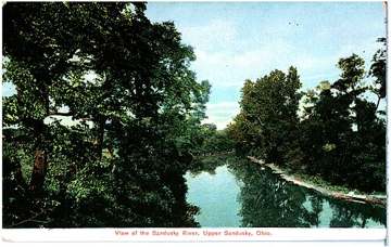
Upper Sandusky City treats its own water from Sandusky River (via Upper Sandusky Reservoirs 1 & 2).
The system's record
- Water bodies
- Sandusky River, Upper Sandusky Reservoir 1, Upper Sandusky Reservoir 2
- Raw intakes
- Reservoir
Sandusky River Reservoir - Serves
- 6,698 people · Wyandot County
- EPA ID
- OH8800511
City pumps from the Sandusky River into its reservoirs (Reservoir 1 built 1957) and treats via a newer integrated membrane plant, consistent with SDWIS intake/reservoir listings.
About this area's water
Did you know
- Upper Sandusky ran the same lime-softening water plant from 1890 until the last decade or so - by the time engineers evaluated it, parts were close to 120 years old and it sat in the river's flood plain.
- Its replacement runs ultrafiltration plus reverse osmosis, a train more typical of seawater desalination than of a city of under 7,000, chosen to strip more than 90 percent of the organics that drive disinfection…
- The city still has eight combined sewer overflows discharging to the same Sandusky River it drinks from, and files 4-hour and 7-day public notices each time one runs.
- Anyone can buy water at the city's bulk station, and filling a swimming pool costs $16.50 per 1,000 gallons plus labor.
History2
- 1890City built a lime-softening water treatment plant, sited in the Sandusky River flood plain; it remained in service for well over a century, with components described as nearly 120 years old when…
- undatedCity replaced the 1890 lime-softening plant with a 21,000-square-foot integrated membrane treatment plant (ultrafiltration plus reverse osmosis) designed by AECOM, driven by tightening disinfection…
Source: aecom.com
Treatment & pressure
How it is treated
Raw water is pumped from the Sandusky River into the city's reservoir(s) for storage - the 2024 CCR names Reservoir #2 - and then treated. AECOM describes the replacement plant as a 21,000-square-foot integrated membrane facility combining ultrafiltration and reverse osmosis, achieving greater than…
Source: aecom.comuppersanduskyoh.com
Water pressure
Not published. No pressure figures, hydraulic model, or pressure-zone map could be found in the city's CCRs, water and sewer pages, or public works pages.
What it costs
$10.50 per 1,000 gallons
Typical household bill about $67 a month for water.
City-published schedule: water consumption $10.50 per 1,000 gallons with a $21.00 per month minimum consumption charge, plus a separate monthly meter unit charge - $25.00 for a…
Source: uppersanduskyoh.com
Water quality & impurities10
| Contaminant | Level | Limit | Year |
|---|---|---|---|
| Total trihalomethanes (TTHM) Range of detections 33.6 to 83.8 ppb; individual samples exceeded 80 ppb but compliance is on a locational running… | 61.4 ppb | 80 ppb MCL | 2024 |
| Haloacetic acids (HAA5) Range 18.2 to 34.0 ppb. | 26.9 ppb | 60 ppb MCL | 2024 |
| Nitrate Range <1.0 to 3.13 ppm; agricultural runoff in the Sandusky River watershed. | 3.13 ppm | 10 ppm MCL | 2024 |
| Atrazine Runoff from herbicide used on row crops. | 0.083 ppb | 3 ppb MCL | 2024 |
| Fluoride Range 0.87 to 1.22 ppm. | 1.22 ppm | 4 ppm MCL | 2024 |
| Copper Range <0.01 to 0.7 ppm; all 20 samples below the action level. | 0.11 ppm | 1.35 ppm action… | 2024 |
| Lead Range <2.0 to 2.8 ppb; all 20 samples below the action level. | <2.0 ppb | 15.5 ppb action… | 2024 |
| Chlorine Range 1.33 to 1.57 ppm. | 1.48 ppm | 4 ppm MRDL | 2024 |
| Turbidity Highest recorded value 0.14 NTU; 100 percent of samples met the standard. | 0.14 NTU | treatment… | 2024 |
| Total organic carbon (TOC) Range 1.61 to 2.10 mg/L. | 2.10 mg/L | treatment… | 2024 |
Source: uppersanduskyoh.com
EPA compliance record
Lead at the tap: 90th-percentile result 0 ppb in 2025 (action level 15 ppb).
EPA record: no health-based violations since 2015.
1 violation of any kind logged since 2020, 1 of them paperwork (monitoring, reporting, public notice or consumer report).
Projects & plans1
Recent and current work
- Integrated membrane water treatment plant (ultrafiltration plus reverse osmosis) · unknown · completed
21,000 square feet; replaced the 1890 lime-softening plant sited in the Sandusky River flood plain, to meet disinfection byproduct rules. Designed by AECOM…
Source: aecom.com
Supply stress
The Ohio EPA source water assessment treats all surface waters as susceptible to contamination, and names the specific threats to Upper Sandusky's protection area: agricultural runoff from fields and feedlots, commercial and industrial sources, leaking underground and aboveground storage tanks, home construction runoff, and quarry…
Source: uppersanduskyoh.com
Sewers
Sanitary
City-operated wastewater treatment plant at 155 Indian Mill Drive, discharging to the Sandusky River under US EPA permit OH0020001 and Ohio EPA permit 2PD000039. Sewer is billed at $14.50 per 1,000 gallons with a $29.00 monthly minimum.
Storm
Partly combined. The city has eight combined sewer overflows that discharge to the Sandusky River and its tributaries, and posts 4-hour and 7-day CSO notices plus an annual CSO notification report under the US EPA's January 2018 public notification rule…
Sourcesverified
Compiled from the utility's own reports and public records, then independently re-checked against primary sources.
Main supplier in 1 ZIP code
Serves
Main water supplier in 1 ZIP code
- 43351 · Upper Sandusky62% of residents
Population-weighted resident shares; a ZIP code can have more than one system on record. Recomputed from each ZIP's own system list, not from the map's cached footprint.
Buys from · Sells to
Upper Sandusky City does not buy water from another system on record; it treats its own source water.
No other system is on record buying water from Upper Sandusky City.
Photograph
On the map
Show this system's territory on the map — 1 ZIP code in all.
Sources
U.S. EPA SDWIS and Community Water System Service Area Boundaries (v3, 2026), Ohio EPA primacy data, 2020 census blocks: the system serving most residents, traced through purchases to the treating utility; Ohio EPA 2023 Sewer and Water Rate Survey (Ohio State, May 2025) for household bills; Ohio EPA DEFA loan awards since 2016 for the loans paragraph · EPA SDWIS · EPA service area boundaries · Ohio EPA drinking water · Ohio EPA rate survey
Upper Sandusky City's own pages: aecom.com
Notable facts: aecom.com, uppersanduskyoh.com, uppersanduskyoh.com
History: aecom.com
Water quality: uppersanduskyoh.com
Capital projects: aecom.com
Rates: uppersanduskyoh.com
Sewers: uppersanduskyoh.com, uppersanduskyoh.com
Treatment: aecom.com, uppersanduskyoh.com
Supply stress: uppersanduskyoh.com