Local events in Uhrichsville
3 events in the next 90 days from 2 public calendars. All local events in Uhrichsville
Checked October 20; the events page is refreshed daily.
Lakes near Uhrichsville
The history under the water: the valley before, the dam, the stories. All Ohio lakes
How Uhrichsville began
Uhrichsville was laid out on the Tuscarawas River in 1833 as "Waterford," but was already known informally as "Uhrich's Mill" for local mill operator Michael Uhrich, and was officially renamed Uhrichsville in 1839. It was incorporated as a village in 1866. It grew first on the Ohio and Erie Canal and then on the Pan Handle Railroad; railroad shops built at neighboring Dennison drew workers and commerce to both towns, which are nicknamed the "Twin Cities." Wikipedia also lists the nickname "Clay Capital of the World." The population peaked at 6,614 in 1950.
Settled 1833 (as Waterford), platted 1833, incorporated 1866 (village; renamed Uhrichsville 1839), by unknown; town associated with mill operator Michael Uhrich.
Where the name comes from
The town was originally laid out as "Waterford" in 1833. It was informally called "Uhrich's Mill" after Michael Uhrich, who operated a mill there, and in 1839 it was officially renamed Uhrichsville after him.
Before the town
No source specific to the town of Uhrichsville describing Native villages, trails, mounds, or treaty lines within its own boundaries is recorded. Uhrichsville sits in the Tuscarawas River valley, which by the 18th century was Delaware (Lenape) country crossed by the river and the Portage Path/Great Trail corridor, and which was ceded to the United States by the Treaty of Greenville (1795); the county's Moravian mission towns (Schoenbrunn, Gnadenhutten, Salem) and Fort Laurens lay elsewhere in the county, upstream and downstream of the Uhrichsville site. Nothing site-specific to Uhrichsville itself is recorded.
Nations recorded here: Lenape (Delaware).
Timeline
- — Michael Uhrich builds a hewed-log dwelling at the south end of what became Water street and keeps the first tavern in the township there.
- — Uhrich builds a grist and saw mill on Big Stillwater, the first or second water mill in the county.
- — Michael Uhrich lays out the town of Waterford on the east side of Big Stillwater in the fall of 1833: 94 lots from First to Sixth street; it was already known as Uhrich's Mill, and the name was changed to Uhrichsville about six years later.
- — Samuel Warfel and Uhrich build a steam saw and carding mill at Third and Water streets.
- — The Waterford Presbyterian Church is organized on November 10 with sixteen members by Rev. James B. Morrow; its brick church is finished about 1843.
- — The town is officially renamed Uhrichsville.
- — The village has 229 residents, up from nothing seven years earlier.
- — Robert M. Dawson adds 122 lots south and east of the original plat.
- — Uhrichsville's population is recorded at 576.
- — Mystic Tie Lodge No. 194 is chartered on October 10; the Steubenville and Indiana (Pan Handle) Railroad is completed about this time and takes the wheat trade away from the canal town.
- — On petition of John Milone and 75 other citizens, the county commissioners incorporate Uhrichsville as a village on August 13; John Milone is elected the first mayor on November 10, 1866.
- — Population is 1,541, rising to 2,790 in 1880 after the railroad shops open across Little Stillwater at Dennison; the Methodist church, a brick building seating 900, is dedicated.
- — The Moravian church is organized on October 24 with fifteen members; its stone church on Water street is finished in 1878.
- — Uhrichsville's population peaks at 6,614, its high point in the U.S. Census record.
- — The Uhrichsville Water Park, with heated pools and water attractions, opens in June.
Stories
From Waterford to Uhrich's Mill to Uhrichsville
The town on this stretch of the Tuscarawas River was laid out in 1833 under the name Waterford, but it was informally known as Uhrich's Mill, after Michael Uhrich, a local mill operator. In 1839 the town was officially renamed Uhrichsville.
The Twin Cities and the Clay Capital of the World
Uhrichsville benefited from the Ohio and Erie Canal and later from the Pan Handle Railroad. Railroad shops were built at nearby Dennison, adding to the growth of both towns, which Wikipedia says are nicknamed the "Twin Cities" because they are adjacent. Wikipedia also lists "Clay Capital of the World" among Uhrichsville's nicknames.
A grain port stranded by the railroad
Uhrichsville was laid out in 1833 on the Ohio Canal's grain trade: wheat came by wagon from thirty or more miles away, from Harrison, Guernsey and part of Carroll counties, and was stored in warehouses (two in 1830, five later) before going down the Stillwater, Tuscarawas and Muskingum. A lock at Trenton about 1838 improved the connection, and George Wallick built canal boats in the village. Then the Steubenville and Indiana, later the Pan Handle, opened about 1850, stations along the line took over the shipping, and Uhrichsville's trade ceased almost entirely. The county history called it a stranded, overgrown country town until the railroad shops at Dennison, begun in 1864, brought workers and rapid growth.
Photographs
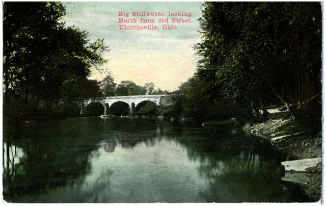
Photo: Commercial Colortype Co. (Chicago), via Columbus Metropolitan Library / Digital Public Library of America, public domain · Wikimedia Commons
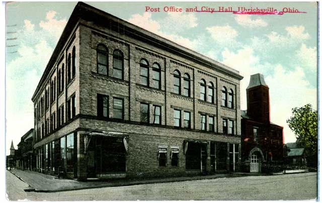
Photo: Columbus Metropolitan Library, via Digital Public Library of America / Ohio Digital Network, public domain · Wikimedia Commons
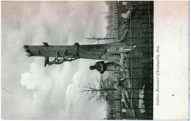
Photo: Columbus Metropolitan Library, via Digital Public Library of America / Ohio Digital Network, public domain · Wikimedia Commons
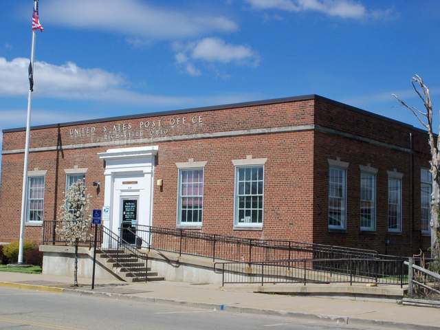
Photo: Wikimedia Commons user Roseohioresident, CC BY-SA 4.0 · Wikimedia Commons
Local history sources: en.wikipedia.org · en.wikipedia.org · en.wikipedia.org · commons.wikimedia.org · commons.wikimedia.org · commons.wikimedia.org · commons.wikimedia.org · archive.org
Water
Tuscarawas River valley aquifer (local wells) The water here
- Twin City Water and Sewer District100% of residentsTuscarawas River valley aquifer (local wells)
Hospitals, fire stations and more
Inside Uhrichsville's boundary: 1 nursing home, 1 fire or EMS station, 4 public schools, 1 poor-rated bridge, 1 library, 1 museum, 1 police station, 1 Toxics Release Inventory facility and 2 spill cases. Press a pin or a name for its whole record and its source.
Nursing homes (1)
-
Claymont Health and Rehabilitation4 of 5 stars · Uhrichsville
- Address
- 5166 Spanson Drive Se, Uhrichsville, OH 44683
- Certified beds
- 55
- Residents on an average day
- 51
- Medicare overall rating
- 4 of 5 stars
- Health inspections
- 4 of 5 stars
- Staffing
- 3 of 5 stars
- Quality measures
- 4 of 5 stars
- Penalties since 2023
- none
- Ownership
- For profit - Corporation
- Chain
- FOUNDATIONS HEALTH SOLUTIONS
- Takes
- Medicare and Medicaid
- Phone
- (740) 922-2208
- Medicare ID
- 366260
Medicare Care Compare ↗ CMS nursing home data (source) ↗ Street map and directions ↗
Source: CMS Care Compare nursing home provider and penalties files; Medicare star ratings run 1 to 5.
Fire and EMS stations (1)
-
Uhrichsville Fire DepartmentUhrichsville
- Address
- 305 East Second Street, Uhrichsville, OH 44683
- Coordinates
- 40.39086, -81.34285
USGS National Map structures (source) ↗ Street map and directions ↗
Source: USGS National Map structures (most Ohio records last updated 2019 to 2022), checked against the Columbus and Cleveland station lists. The department that answers a call is set by jurisdiction and mutual aid, not by distance.
Public schools (4)
-
Claymont Elementary School3 of 5 stars · Uhrichsville
- Address
- 320 Trenton Ave, Uhrichsville, OH 44683
- School district
- Claymont City School District
- Kind (NCES)
- Regular School
- Students, 2023-24
- 267
- Teachers (full-time equivalent)
- 13.5
- Report card, 2025-26
- 3 of 5 stars
- Ohio building IRN
- 009688
- NCES school ID
- 390437700406
NCES school record ↗ Ohio School Report Card ↗ Street map and directions ↗
-
Claymont High School3 of 5 stars · Uhrichsville
- Address
- 4205 Indian Hill Rd SE, Uhrichsville, OH 44683
- School district
- Claymont City School District
- Kind (NCES)
- Regular School
- Students, 2023-24
- 380
- Teachers (full-time equivalent)
- 25.25
- Report card, 2025-26
- 3 of 5 stars
- Performance index
- 72.9%
- Four-year graduation rate
- 91.7%
- Ohio building IRN
- 006528
- NCES school ID
- 390437700405
NCES school record ↗ Ohio School Report Card ↗ Street map and directions ↗
-
Claymont Middle School3.5 of 5 stars · Uhrichsville
- Address
- 215 E 6th St, Uhrichsville, OH 44683
- School district
- Claymont City School District
- Kind (NCES)
- Regular School
- Students, 2023-24
- 377
- Teachers (full-time equivalent)
- 22
- Report card, 2025-26
- 3.5 of 5 stars
- Performance index
- 75.6%
- Ohio building IRN
- 006510
- NCES school ID
- 390437700404
NCES school record ↗ Ohio School Report Card ↗ Street map and directions ↗
-
Claymont Primary School4 of 5 stars · Uhrichsville
- Address
- 1200 Eastport Ave, Uhrichsville, OH 44683
- School district
- Claymont City School District
- Kind (NCES)
- Regular School
- Students, 2023-24
- 224
- Teachers (full-time equivalent)
- 11.5
- Report card, 2025-26
- 4 of 5 stars
- Ohio building IRN
- 037473
- NCES school ID
- 390437700410
NCES school record ↗ Ohio School Report Card ↗ Street map and directions ↗
Source: NCES EDGE public school locations 2024-25 and Common Core of Data 2023-24 (type, students, teachers); Ohio School Report Cards 2025-26 (Department of Education and Workforce), matched by name within the district.
Bridges rated poor (1)
-
West 3rd Street over Big Stillwater CreekPoor · built 1985
- Condition
- Poor: a deck, superstructure, substructure or culvert rated 4 or below on the 0 to 9 scale
- What it is
- Bridge
- Built
- 1985
- Length
- 34 ft
- Owner
- City
- Vehicles a day
- 1,022
- Coordinates
- 40.39097, -81.34733
National Bridge Inventory (source) ↗ Street map and directions ↗
Source: FHWA National Bridge Inventory 2025. "Poor" means one major part rated 4 or below on the 0 to 9 scale; it calls for repair, not closing, unless the state posts or closes the bridge.
Public libraries (1)
-
Claymont School District Public LibraryCentral library · Uhrichsville
- Address
- 215 E. Third St., Uhrichsville, OH 44683
- What it is
- Central library
- Library system
- Claymont School District Public Library
- Open
- 1,976 hours a year, 52 weeks
- Building
- 10,259 sq ft
- System's visits, FY2024
- 9,724
- System's loans, FY2024
- 106,717
- People the system serves
- 11,834
- Phone
- (740) 922-3626
IMLS Public Libraries Survey (source) ↗ Street map and directions ↗
Source: IMLS Public Libraries Survey FY2024 (outlets and their systems). Any Ohio resident can get a free card at any Ohio public library.
Museums, historical societies, gardens and zoos (1)
-
Uhrichsville Clay MuseumMuseum · Uhrichsville
- What it is
- Museum
- City
- Uhrichsville
- Coordinates
- 40.39153, -81.34511
Search Wikipedia ↗ IMLS Museum Data Files (source) ↗ Street map and directions ↗
The museum list is IMLS's 2018 file; a museum may have closed or moved since.
Source: IMLS Museum Data Files, 2018.
Police stations (1)
-
Uhrichsville Police DepartmentUhrichsville
- Address
- 305 East Second Street, Uhrichsville, OH 44683
- Coordinates
- 40.39083, -81.34316
USGS National Map structures (source) ↗ Street map and directions ↗
Source: USGS National Map structures, police stations, corrected and completed by hand (September 2026). The department that answers a call is set by jurisdiction, not by distance.
Facilities reporting toxic releases (1)
-
Superior Clay CorpToxics Release Inventory · Uhrichsville
- Address
- 6566 Superior Rd Se, P.O. Box 352, Uhrichsville, OH 44683
- County
- Tuscarawas County
- Status
- Reports to the Toxics Release Inventory (active)
- EPA program ID
- 44683SPRRC6566S
- EPA registry ID
- 110006529006
EPA facility record ↗ EPA Facility Registry Service (source) ↗ Street map and directions ↗
Source: EPA Facility Registry Service, Toxics Release Inventory reporters. Reporting a release is required of large users of listed chemicals; it is not by itself a violation.
Spills reported since 2021 (2)
-
Natural Gas2024-06-15 · Mill Twp
- Reported
- 2024-06-15
- What spilled
- Natural Gas
- Where
- Mill Twp, Tuscarawas County
- Ohio EPA district office
- SEDO
- Ohio EPA case number
- 2406EPA0001010
Ohio EPA spill reports (source) ↗ Street map and directions ↗
-
Oil Crude Reached water2022-09-02 · Uhrichsville
- Reported
- 2022-09-02
- What spilled
- Oil Crude; Brine Oil And Gas Related
- Reached a waterway
- 99 - Unnamed
- Where
- Uhrichsville, Tuscarawas County
- Ohio EPA district office
- SEDO
- Ohio EPA case number
- 2209EPA0001347
Ohio EPA spill reports (source) ↗ Street map and directions ↗
Source: Ohio EPA emergency response spill reports, 2021 to September 2026, one point per case where Ohio EPA placed it. A report is what the caller or responder recorded; amounts are often blank or estimated.
Its ZIP codes
Each ZIP code that touches Uhrichsville, with the share of its residents who live here and the same headline figures as the ZIP page.
| ZIP | Share | Water | Radon | Home value | Schools | Flood |
|---|---|---|---|---|---|---|
| 44683 Uhrichsville | 63% | Tuscarawas River valley aquifer (local wells) | 5.8 pCi/L average radon | Median year built 1927 | Claymont City · 3 stars overall | 12% of residents in the 1% floodplain |
Local government
Who holds office in Uhrichsville, how its elections and ballot issues came out, and the state auditor's record.
Money issues on the ballot since 2019: 6 of 6 passed.
Ballot issues
| Date | Issue | For | Against | Result |
|---|---|---|---|---|
| 2025-05-06 | 3: 3 City of Uhrichsville Fire Levy (Renewal) | 143 | 44 | Passed (76.47% for) |
| 2025-05-06 | 16: 16 City of Uhrichsville Ambulance Services Levy (Renewal) | 145 | 42 | Passed (77.54% for) |
| 2022-05-03 | 1: 1 Proposed Tax Levy (Renewal)Joint Union Cemetery (Including City of Uhrichsville, Village of | 579 | 190 | Passed (75.29% for) |
| 2021-05-04 | 2: 2 City of Uhrichsville | 105 | 51 | Passed (67.31% for) |
| 2020-03-17 | 6: 6 Renewal City of Uhrichsville | 371 | 207 | Passed (64.19% for) |
| 2020-03-17 | 7: 7 Renewal City of Uhrichsville | 383 | 193 | Passed (66.49% for) |
| 2019-11-05 | Issue: City of Uhrichsville Renewal Uhrichsville | 313 | 137 | Passed (69.56% for) |
Elections for office
| Date | Office | Candidates and votes |
|---|---|---|
| 2019-11-05 | Member of Council, Ward 4 | Amy L. Myers 103, 100.0% |
| 2019-11-05 | Member of Council, Ward 3 | Michael Huff Jr. 65, 100.0% |
| 2019-11-05 | Member of Council, Ward 2 | Ronald Miller 69, 100.0% |
| 2019-11-05 | Mayor | Mark Haney 359, 100.0% |
| 2019-11-05 | Auditor | Julie Pearch 399, 100.0% |
| 2019-05-07 | Member of Council, Ward 4 (DEM primary) | Amy L. Myers 76, 100.0% |
| 2019-05-07 | Member of Council, Ward 2 (DEM primary) | Ronald Miller 51, 100.0% |
| 2019-05-07 | Mayor (DEM primary) | Rick Dorland 162, 45.13%; Mark Haney 197, 54.87% |
Winners in bold. Results from the county board of elections' official canvass unless marked.
Auditor of State record
- Fiscal emergency: declared 1998-08-06, released 2003-09-16. source
- Fiscal watch: declared 1997-12-31, released 1998-08-06. source
- Financial Health Indicators (the Auditor of State's 17 measures; critical / cautionary / positive): 2017 1 / 2 / 14; 2018 2 / 3 / 12; 2019 1 / 0 / 16; 2020 0 / 2 / 15; 2021 0 / 1 / 16; 2022 1 / 3 / 12.
- Financial Audit, 2022 to 2023, released 2025-12-02
- OP&F Examination, 2023, released 2025-05-08
The county
Tuscarawas County: 17 ZIP codes, 40 cities, villages and townships, 92,903 people.
Nearby places
Rain and snow
How much has actually fallen on Uhrichsville, day by day, from 1893 to now. Daily totals, not averages.
- rain, last 30 days
- 0.91 in
- 2026-09-30 to 2026-10-29
- rain so far in 2026
- 36.0 in
- about normal for the date
- snow so far in 2026
- 22.4 in
- a normal year brings 17.6 in
- a normal year
- 42.6 in
- average of 30 years, 1991-2020
| Month | Rain (in) | Snow (in) | Days counted |
|---|---|---|---|
| October 2026 | 0.91 | — | 29 |
| September 2026 | 2.66 | — | 30 |
| August 2026 | 6.21 | — | 31 |
| July 2026 | 4.26 | — | 31 |
| June 2026 | 3.67 | — | 30 |
| May 2026 | 4.36 | — | 31 |
| April 2026 | 4.45 | — | 30 |
| March 2026 | 5.90 | 1.1 | 31 |
| February 2026 | 1.41 | 2.4 | 28 |
| January 2026 | 2.14 | 18.9 | 31 |
| December 2025 | 2.33 | 10.3 | 31 |
| November 2025 | 2.27 | 0.1 | 30 |
| Wettest year | 2004 — 64.9 in |
|---|---|
| Driest year | 1930 — 24.7 in |
| Snowiest year | 1960 — 58.8 in |
| Wettest day on record | 8 September 2004 — 4.43 in |
| Heaviest snowfall in a day | 3 April 1987 — 12.01 in |
| Deepest snow on the ground | 28 November 1950 — 22.01 in |
69% of these days are measurements from a gauge inside Uhrichsville; the rest are estimated from the nearest gauges around it.
48,736 days of records, 1893-01-01 to 2026-10-29. Source: NOAA NCEI GHCN-Daily, 3,240 gauges in and around Ohio. A day is "gauged" when a gauge standing inside the boundary reported it, and the value is the mean of those gauges. Otherwise it is interpolated by inverse distance from every gauge reporting within 50 miles. Nothing is carried forward, back-filled or smoothed. Against NOAA nClimDiv county monthly precipitation over 136,848 complete county-months (checked 2026-10-31): correlation 0.9515, median absolute difference 0.217 in a month. Built 2026-10-31 from the Cracked Buckeye precipitation archive. Snow is the softer number — snowfall is measured by hand with a ruler, no agency publishes a gridded county snowfall series, and blowing snow defeats every observer.
Environmental permits and filings
What Ohio EPA has on file for Uhrichsville: permits, inspections, violations, cleanups and the state loans behind sewer and water work. Every line links to the agency's own document.
- facilities and sites on file
- 26
- those placed on the map inside Uhrichsville
| Program | Facilities and sites |
|---|---|
| Hazardous waste | 10 |
| State sewer loans | 6 |
| State water loans | 6 |
| Scrap tires | 2 |
| Air pollution | 1 |
| Wastewater and stormwater discharge | 1 |
| Date | Facility or site | What |
|---|---|---|
| SEMCO CERAMICS INC | Air pollution report | |
| PIR 4070-WEST 10TH STREET AND PARISH STREET | Wastewater and stormwater discharge permit | |
| MOVIN ON STORAGE DAVIS ST | Scrap tires cleanup response | |
| RUMMELL'S STORAGE LARSON SE RD | Scrap tires cleanup response | |
| RUMMELL'S STORAGE LARSON SE RD | Scrap tires cleanup response | |
| MOVIN ON STORAGE DAVIS ST | Scrap tires cleanup response | |
| RUMMELL'S STORAGE LARSON SE RD | Scrap tires cleanup response | |
| RUMMELL'S STORAGE LARSON SE RD | Scrap tires cleanup response | |
| MOVIN ON STORAGE DAVIS ST | Scrap tires cleanup response | |
| SEMCO CERAMICS INC | Air pollution permit | |
| SEMCO CERAMICS INC | Air pollution permit | |
| TWIN CITY WATER AND SEWER DISTRICT PWS | State water loans | |
| TWIN CITY WATER AND SEWER DISTRICT PWS | State water loans | |
| TWIN CITY WATER AND SEWER DISTRICT PWS | State water loans | |
| TWIN CITY WATER AND SEWER DISTRICT PWS | State water loans | |
| SEMCO CERAMICS INC | Air pollution permit | |
| SEMCO CERAMICS INC | Air pollution permit | |
| SEMCO CERAMICS INC | Air pollution director's orders | |
| SEMCO CERAMICS INC | Air pollution permit | |
| SEMCO CERAMICS INC | Air pollution inspection | |
| RITE AID #2414 | Hazardous waste compliance letter | |
| TWIN CITY WATER AND SEWER DISTRICT PWS | State water loans | |
| SEMCO CERAMICS INC | Air pollution notice of violation | |
| CIRCLE K #5566 | Hazardous waste compliance letter | |
| SEMCO CERAMICS INC | Air pollution inspection |
Source: Ohio EPA eDocument portal (edocpub.epa.ohio.gov), indexed 2026-10-14. Facilities are placed on the map from Ohio EPA's own map layers, EPA's Facility Registry, coordinates written in the filings, or a geocoded street address. A permit filed under a private person's name (most are household septic systems) is counted but never named, placed or linked; licenses for individual workers and open-burning notices are left out entirely.
Quick answers
What county is Uhrichsville, Ohio in?
Uhrichsville is a city in Tuscarawas County, Ohio, with 5,256 residents.
When was Uhrichsville, Ohio founded?
Uhrichsville was settled 1833 (as Waterford); laid out 1833; incorporated 1866 (village; renamed Uhrichsville 1839). Founders on record: unknown; town associated with mill operator Michael Uhrich. Source
How did Uhrichsville, Ohio get its name?
The town was originally laid out as "Waterford" in 1833. Source
What ZIP code is Uhrichsville, Ohio?
Most of Uhrichsville is in ZIP code 44683.
Where does Uhrichsville, Ohio get its water?
The main water source for Uhrichsville (Twin City Water and Sewer District): Tuscarawas River valley aquifer (local wells).
Cite this page
Cite this page as:
Cracked Buckeye, "Uhrichsville, Tuscarawas County", https://crackedbuckeye.com/place/uhrichsville/, built 2026-10-31, accessed [date].
How to cite · Report a correction · Built 2026-10-31
