Local events in St Paris
St Paris itself has 2 events posted in the next 90 days; the others here are within 10 miles. All local events in St Paris
Checked October 20; the events page is refreshed daily.
How St Paris began
St. Paris, in Johnson Township in western Champaign County, was founded in 1831 by David Huffman, who first called it New Paris after the French capital; learning of another New Paris already in Ohio, he added 'Saint' to keep the mail from going astray, and the village incorporated in 1858. Two railroads reached it in the 1840s and 1850s and turned it into a shipping point for the surrounding farm country, a role it kept until the last line was abandoned in 1983. It holds two National Register buildings from its early-twentieth-century prosperity, the Kiser Mansion and the architecturally unusual Monitor House.
Settled 1797 (first white settlers in the area), platted 1831, incorporated 1858, by David Huffman.
Where the name comes from
Huffman first named his village New Paris, after the French capital. On finding that another Ohio town already carried that name, he prefixed 'Saint' so mail addressed to the two towns would not be confused, giving St. Paris its final name.
Before the town
St. Paris's own Wikipedia article states plainly that the ground it stands on was originally inhabited by Native Americans before white settlement, without naming a specific nation or village at the site itself. The area lies in Johnson Township along the upper Mad River drainage, within the broader region of Shawnee towns and hunting ground before the Treaty of Greenville (1795); no site-specific village, mound, or trail inside the village of St. Paris was found in the sources checked.
Nations recorded here: Shawnee.
Timeline
- — The first white settlers arrived in the area that became St. Paris.
- — David Huffman platted the village in Johnson Township, first naming it New Paris and then St. Paris.
- — The Columbus and Piqua Railroad was built along the village's southern edge, boosting local commerce.
- — St. Paris incorporated as a village.
- — The Columbus, Piqua and Indiana Railroad opened on March 25, becoming the chief carrier for the area's agricultural products.
- — The post office at Nettleton, a short-lived hamlet between St. Paris and Urbana, operated for four years before closing.
- — John and Thyrza Kiser built the Classical Revival Kiser Mansion on East Main Street; the family later donated the building that became the village library and the land that is now Kiser Lake.
- — The last successor railroad through St. Paris, by then part of Conrail, was abandoned.
Stories
A house that hides its own history
Sometime around 1860 someone in St. Paris built a brick house with an unusual feature: a raised, windowed clerestory box rising from the center of its roof, a style called a 'monitor house' after the shape of the Civil War ironclad. No record survives of who built it, who designed it, or who lived there first. It is one of only two or three monitor-style houses known anywhere in Ohio, and architectural historians consider it the best-preserved of them, more intact than its nearest cousin, Tanglewood, in Chillicothe. When the National Register of Historic Places began listing Champaign County properties in 1974, the Monitor House on West Main Street was the very first to be added - the county's Register history in effect starts with a building whose own history is a blank.
Photographs
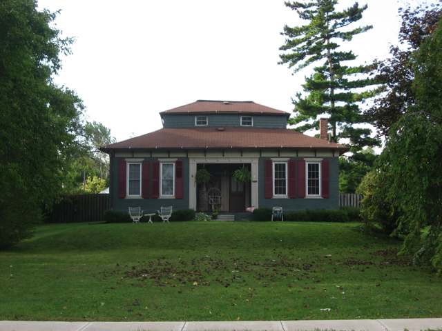
Photo: Wikimedia Commons contributor, public domain · Wikimedia Commons
Local history sources: en.wikipedia.org · en.wikipedia.org · gohistoric.com · en.wikipedia.org · roadsidethoughts.com
Historic places
2 places in St Paris on the National Register of Historic Places. Press a pin or a name for its whole record.
-
Kiser MansionBuilding · Saint Paris · listed 2011
- Address
- 149 E. Main St
- Where
- Saint Paris, Champaign County · ZIP 43072
- What it is
- Building
- Listed on the National Register
- 2011
- NRIS reference number
- 10001211
- Coordinates
- 40.12782, -83.95742
National Register file (NPS) ↗ Search Wikipedia ↗ Street map and directions ↗ On the Cracked Buckeye map
-
Monitor HouseBuilding · Saint Paris · listed 1974
- Address
- 375 W. Main St.
- Where
- Saint Paris, Champaign County · ZIP 43072
- What it is
- Building
- Listed on the National Register
- 1974
- NRIS reference number
- 74001408
- Coordinates
- 40.12936, -83.96717
National Register file (NPS) ↗ Search Wikipedia ↗ Street map and directions ↗ On the Cracked Buckeye map
Source: National Park Service, National Register of Historic Places point file. The listing year is shown where NPS's certification date agrees with the listing's reference number. Listing recognizes significance; it does not restrict a private owner.
Water
Mostly private wells The water here
- Saint Paris Village86% of residentsGroundwater wells (3 wells)
- Christiansburg Village10% of residentsGroundwater wells (2 wells)
- Grandview Heights Civic Association5% of residentsGroundwater wells (2 wells)
Hospitals, fire stations and more
Inside St Paris's boundary: 1 fire or EMS station, 2 public schools, 1 library, 1 police station and 1 spill case. Press a pin or a name for its whole record and its source.
Fire and EMS stations (1)
-
JPS Joint Fire DistrictSaint Paris
- Address
- 403 West Main Street, Saint Paris, OH 43072
- Coordinates
- 40.12985, -83.97061
USGS National Map structures (source) ↗ Street map and directions ↗
Source: USGS National Map structures (most Ohio records last updated 2019 to 2022), checked against the Columbus and Cleveland station lists. The department that answers a call is set by jurisdiction and mutual aid, not by distance.
Public schools (2)
-
Graham Elementary School4 of 5 stars · Saint Paris
- Address
- 9464 US Highway 36, Saint Paris, OH 43072
- School district
- Graham Local School District
- Kind (NCES)
- Regular School
- Students, 2023-24
- 746
- Teachers (full-time equivalent)
- 37
- Report card, 2025-26
- 4 of 5 stars
- Performance index
- 80%
- Ohio building IRN
- 014035
- NCES school ID
- 390461902466
NCES school record ↗ Ohio School Report Card ↗ Street map and directions ↗
-
Graham Middle School4 of 5 stars · Saint Paris
- Address
- 9644 Us Highway 36, Saint Paris, OH 43072
- School district
- Graham Local School District
- Kind (NCES)
- Regular School
- Students, 2023-24
- 390
- Teachers (full-time equivalent)
- 23
- Report card, 2025-26
- 4 of 5 stars
- Performance index
- 77.6%
- Ohio building IRN
- 035675
- NCES school ID
- 390461902464
NCES school record ↗ Ohio School Report Card ↗ Street map and directions ↗
Source: NCES EDGE public school locations 2024-25 and Common Core of Data 2023-24 (type, students, teachers); Ohio School Report Cards 2025-26 (Department of Education and Workforce), matched by name within the district.
Public libraries (1)
-
St. Paris Public LibraryCentral library · St. Paris
- Address
- 127 E. Main St., St. Paris, OH 43072
- What it is
- Central library
- Library system
- St. Paris Public Library
- Open
- 2,678 hours a year, 52 weeks
- Building
- 10,000 sq ft
- System's visits, FY2024
- 0
- System's loans, FY2024
- 70,229
- People the system serves
- 5,617
- Phone
- (937) 663-4349
IMLS Public Libraries Survey (source) ↗ Street map and directions ↗
Source: IMLS Public Libraries Survey FY2024 (outlets and their systems). Any Ohio resident can get a free card at any Ohio public library.
Police stations (1)
-
Saint Paris Police DepartmentSaint Paris
- Address
- 137 West Main Street, Saint Paris, OH 43072
- Coordinates
- 40.12806, -83.96010
USGS National Map structures (source) ↗ Street map and directions ↗
Source: USGS National Map structures, police stations, corrected and completed by hand (September 2026). The department that answers a call is set by jurisdiction, not by distance.
Spills reported since 2021 (1)
-
Sewage Human2025-05-10 · St Paris
- Reported
- 2025-05-10
- What spilled
- Sewage Human
- Where
- St Paris, Champaign County
- Ohio EPA district office
- SWDO
- Ohio EPA case number
- 2505EPA0000738
Ohio EPA spill reports (source) ↗ Street map and directions ↗
Source: Ohio EPA emergency response spill reports, 2021 to September 2026, one point per case where Ohio EPA placed it. A report is what the caller or responder recorded; amounts are often blank or estimated.
Its ZIP codes
Each ZIP code that touches St Paris, with the share of its residents who live here and the same headline figures as the ZIP page.
| ZIP | Share | Water | Radon | Home value | Schools | Flood |
|---|---|---|---|---|---|---|
| 43072 St Paris and Saint Paris | 34% | Mostly private wells | 5.2 pCi/L average radon | Median year built 1965 | Graham Local · 4.5 stars overall | 0.5% of residents in the 1% floodplain |
Local government
Who holds office in St Paris, how its elections and ballot issues came out, and the state auditor's record.
Money issues on the ballot since 2020: 2 of 2 passed.
Ballot issues
| Date | Issue | For | Against | Result |
|---|---|---|---|---|
| 2022-11-08 | Issue: V ST PARIS TAX RENEWAL | 347 | 270 | Passed (56.24% for) |
| 2020-03-17 | Issue: V-St. Paris Addln Mill | 219 | 156 | Passed (58.4% for) |
Auditor of State record
- No fiscal caution, watch or emergency on the Auditor of State's lists.
- Agreed Upon Procedures, 2022 to 2023, released 2024-08-06
The county
Champaign County: 9 ZIP codes, 17 cities, villages and townships, 37,209 people.
Nearby places
Rain and snow
How much has actually fallen on St Paris, day by day, from 1893 to now. Daily totals, not averages.
- rain, last 30 days
- 0.95 in
- 2026-09-30 to 2026-10-29
- rain so far in 2026
- 41.6 in
- 5.6 in above normal for the date
- snow so far in 2026
- 19.7 in
- a normal year brings 15.8 in
- a normal year
- 42.4 in
- average of 30 years, 1991-2020
| Month | Rain (in) | Snow (in) | Days counted |
|---|---|---|---|
| October 2026 | 0.95 | — | 29 |
| September 2026 | 6.62 | — | 30 |
| August 2026 | 6.34 | — | 31 |
| July 2026 | 3.86 | — | 31 |
| June 2026 | 2.89 | — | 30 |
| May 2026 | 9.11 | — | 31 |
| April 2026 | 3.10 | — | 30 |
| March 2026 | 5.84 | 2.3 | 31 |
| February 2026 | 1.13 | 3.9 | 28 |
| January 2026 | 1.82 | 13.4 | 31 |
| December 2025 | 1.95 | 10.2 | 31 |
| November 2025 | 1.72 | 1.4 | 30 |
| Wettest year | 2011 — 58.5 in |
|---|---|
| Driest year | 1934 — 25.2 in |
| Snowiest year | 1910 — 69.2 in |
| Wettest day on record | 26 June 1971 — 3.94 in |
| Heaviest snowfall in a day | 26 November 1950 — 14.45 in |
| Deepest snow on the ground | 18 February 1910 — 17.99 in |
Estimated, not measured. No rain gauge has ever stood inside St Paris, so every figure here is worked out from the gauges around it - the nearest ones weighted most. Treat them as close estimates rather than readings.
48,700 days of records, 1893-01-01 to 2026-10-29. Source: NOAA NCEI GHCN-Daily, 3,240 gauges in and around Ohio. A day is "gauged" when a gauge standing inside the boundary reported it, and the value is the mean of those gauges. Otherwise it is interpolated by inverse distance from every gauge reporting within 50 miles. Nothing is carried forward, back-filled or smoothed. Against NOAA nClimDiv county monthly precipitation over 136,848 complete county-months (checked 2026-10-31): correlation 0.9515, median absolute difference 0.217 in a month. Built 2026-10-31 from the Cracked Buckeye precipitation archive. Snow is the softer number — snowfall is measured by hand with a ruler, no agency publishes a gridded county snowfall series, and blowing snow defeats every observer.
Environmental permits and filings
What Ohio EPA has on file for St Paris: permits, inspections, violations, cleanups and the state loans behind sewer and water work. Every line links to the agency's own document.
- facilities and sites on file
- 5
- those placed on the map inside St Paris
| Program | Facilities and sites |
|---|---|
| Brownfield | 3 |
| Hazardous waste | 2 |
| Date | Facility or site | What |
|---|---|---|
| E MAIN ST SILOS, SAINT PARIS | Brownfield assessment | |
| E MAIN ST SILOS, SAINT PARIS | Brownfield assessment | |
| OLD JUNIOR HIGH SAINT PARIS | Brownfield assessment | |
| OLD JUNIOR HIGH SAINT PARIS | Brownfield assessment | |
| OLD JUNIOR HIGH SAINT PARIS | Brownfield assessment | |
| OLD JUNIOR HIGH SAINT PARIS | Brownfield assessment | |
| OLD JUNIOR HIGH SAINT PARIS | Brownfield assessment |
Source: Ohio EPA eDocument portal (edocpub.epa.ohio.gov), indexed 2026-10-14. Facilities are placed on the map from Ohio EPA's own map layers, EPA's Facility Registry, coordinates written in the filings, or a geocoded street address. A permit filed under a private person's name (most are household septic systems) is counted but never named, placed or linked; licenses for individual workers and open-burning notices are left out entirely.
Quick answers
What county is St Paris, Ohio in?
St Paris is a village in Champaign County, Ohio, with 1,860 residents.
When was St Paris, Ohio founded?
St Paris was settled 1797 (first white settlers in the area); laid out 1831; incorporated 1858. Founders on record: David Huffman. Source
How did St Paris, Ohio get its name?
Huffman first named his village New Paris, after the French capital. Source
What ZIP code is St Paris, Ohio?
Most of St Paris is in ZIP code 43072.
Where does St Paris, Ohio get its water?
The main water source for St Paris (Saint Paris Village): Mostly private wells.
Cite this page
Cite this page as:
Cracked Buckeye, "St Paris, Champaign County", https://crackedbuckeye.com/place/st-paris/, built 2026-10-31, accessed [date].
How to cite · Report a correction · Built 2026-10-31
