Local events in Russells Point
Russells Point itself has 1 event posted in the next 90 days; the others here are within 10 miles. All local events in Russells Point
Checked October 20; the events page is refreshed daily.
Lakes near Russells Point
The history under the water: the valley before, the dam, the stories. All Ohio lakes
Videos about Russells Point
Short videos we made from the old maps and records. All videos
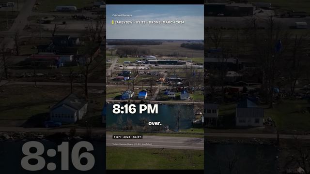
How Russells Point began
Russells Point sits on the south shore of Indian Lake in Logan County, on land held by a landowner named James Russell; a post office named for the place opened in 1913 and the lakeside settlement grew into a resort town. The lake itself was built in the 1850s as a canal-feeder reservoir on the former Lewistown Reservation, a tract of about 48 square miles created by the 1817 Treaty of Fort Meigs for Shawnee and Seneca people and given up under the Treaty of Lewistown (1829 and 1831). Russells Point's population was 1,619 in 2000 and 1,320 in 2020. On March 14, 2024, an EF-3 tornado struck the village, killing at least three people.
Incorporated late 1920s (post office established 1913), by named for landowner James Russell.
Where the name comes from
Named for the Russell family, whose homestead sat on the point of land that became the village. Wikipedia says the village and post office were named for James Russell, owner of the town site; the Logan County History Center says John Russell, born in 1847 to James and Amanda Russell, leased seven acres of government land there in October 1891 and sold it in 1894.
Before the town
The land under Indian Lake was the Lewistown Reservation. Quatawapea (Colonel Lewis) and his Shawnee followers founded the village of Lewistown in what is now Logan County about 1796; the 1817 Treaty of Fort Meigs (Maumee Rapids) created a reservation of about 48 square miles there, which the Shawnee shared with Seneca (Mingo) people living in the village. Quatawapea left for Arkansas in 1825 with about 255 Shawnees and a few Senecas and died in 1826. The Shawnee and Seneca who remained, about 300 people, gave up the reservation in the Treaty of Lewistown (signed August 3, 1829 and again July 20, 1831) in exchange for 60,000 acres west of the Mississippi. The state built the Lewistown Reservoir, now Indian Lake, on the land in the 1850s. No separate Native site inside Russells Point itself is recorded.
Nations recorded here: Shawnee, Mingo (Seneca-Cayuga).
- Lewistown Reservation (treaty) — tract including the present Indian Lake / Russells Point area, Logan County, 1817 (reservation created) to 1831 (ceded) (en.wikipedia.org)
Timeline
- — The Treaty of Fort Meigs (Maumee Rapids) creates a Lewistown reservation of about 48 square miles in present Logan County, which Shawnee share with Senecas living in the village of Lewistown.
- — The Treaty of Lewistown is signed by Shawnee and Seneca members on August 3, 1829 and again on July 20, 1831; about 300 Indians give up the Lewistown Reservation in exchange for 60,000 acres west of the Mississippi River and a $6,000 advance on the sale of their Ohio lands.
- — The State of Ohio built the Lewistown Reservoir, now Indian Lake, on the former reservation as a feeder reservoir for the Miami and Erie Canal.
- — A photograph of a hunting and fishing camp at the Lewistown Reservoir at the point is dated 1888 in the Logan County History Center's account of Russells Point.
- — John Russell leases seven acres of government land at the point from the state's Bureau of Public Works for $48 a year over fifteen years.
- — Russell ends his lease and sells the land to James A. Marshall and Elmer McLaughlin; the family moves to a farm near Ada.
- — A post office named Russells Point began operating, named for landowner James Russell; the lakeside village grew as an Indian Lake resort town.
- — The community incorporates as a village in the late 1920s.
- — Pappy Wilgus opens Sandy Beach Amusement Park to the public, later promoted as the Atlantic City of the West, on the lakefront.
- — A national endurance dance marathon at the Minnewawa dance hall lasts 80 days and 2 hours.
- — A fire destroys much of the park's wooden structures, including the Minnewawa Dance Hall; the Moonlight Terrace, an Art Deco bandshell with an open-air dance floor, replaces the hall.
- — More than 100,000 people attend the Ohio Sesquicentennial celebration at Indian Lake.
- — A riot involving nearly 500 youths breaks out at Russells Point bars and spreads to the park area.
- — The park is combined and renamed Indian Lake Playland; it closes in 1975 and its property is razed in 1982.
- — Village population reached its recorded peak of 1,619 residents.
- — The renovated Sandy Beach footbridge between the two sides of the old park reopens to the public.
- — The census counts 1,320 people in Russells Point, down from 1,619 in 2000.
- — An EF-3 tornado struck Russells Point around 7:51 p.m., killing at least three people and severely damaging homes and businesses across the village.
Stories
A reservation becomes a resort
Before it was a lake, the ground under Indian Lake was the Lewistown Reservation. Quatawapea, the Shawnee leader known to Americans as Colonel Lewis, and his followers founded Lewistown in what is now Logan County about 1796. The 1817 Treaty of Fort Meigs created a reservation of about 48 square miles there, which the Shawnee shared with Senecas living in the village. Quatawapea left for Arkansas in 1825 with about 255 Shawnees and a few Senecas and died there in 1826. The remaining Shawnee and Seneca, about 300 people, gave up the reservation in the Treaty of Lewistown, signed in 1829 and again in 1831, for 60,000 acres west of the Mississippi. In the 1850s the state flooded the lowland as the Lewistown Reservoir to feed the Sidney Feeder of the Miami and Erie Canal, and the reservoir later became Indian Lake. A post office named Russells Point opened in 1913 on land once owned by James Russell.
The 2024 tornado
On the evening of March 14, 2024, a tornado struck Russells Point at about 7:51 p.m. The National Weather Service later rated it EF-3. At least three people were killed.
The Atlantic City of the West
Pappy Wilgus opened Sandy Beach Amusement Park on the point of land at Indian Lake on May 29, 1924, and the park was promoted as the Atlantic City of the West. In 1931 the Minnewawa dance hall held a National Endurance Dance Marathon that lasted 80 days and 2 hours. A fire in 1935 destroyed much of the park's wooden structures; the Moonlight Terrace, an Art Deco bandshell with an open-air dance floor, replaced the dance hall. More than 100,000 people attended the Ohio Sesquicentennial celebration at Indian Lake in 1953, and a riot involving nearly 500 youths broke out on the evening of July 4, 1961. The park was renamed Indian Lake Playland in 1967, closed in 1975 and was razed in 1982; the renovated footbridge that joined its two sides reopened on August 23, 2014.
Photographs
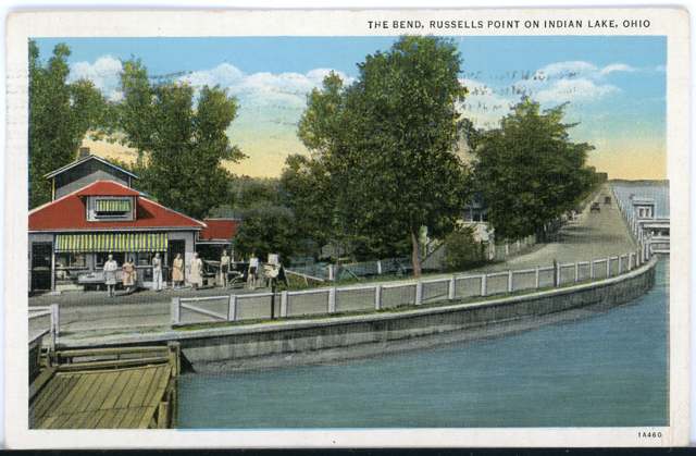
Photo: Columbus Metropolitan Library, via Digital Public Library of America, no known copyright restrictions · Wikimedia Commons
Local history sources: en.wikipedia.org · en.wikipedia.org · en.wikipedia.org · commons.wikimedia.org · russellspoint-oh.gov · loganhistory.org · rcdb.com · en.wikipedia.org · treaties.okstate.edu
Water
Groundwater wells (3 wells) The water here
- Russells Point Village100% of residentsGroundwater wells (3 wells)
Hospitals, fire stations and more
Inside Russells Point's boundary: 1 fire or EMS station, 1 police station and 2 spill cases. Press a pin or a name for its whole record and its source.
Fire and EMS stations (1)
-
Indian Joint Fire DistrictRussells Point
- Address
- 320 South Orchard Island Road, Russells Point, OH 43348
- Coordinates
- 40.46793, -83.89276
USGS National Map structures (source) ↗ Street map and directions ↗
Source: USGS National Map structures (most Ohio records last updated 2019 to 2022), checked against the Columbus and Cleveland station lists. The department that answers a call is set by jurisdiction and mutual aid, not by distance.
Police stations (1)
-
Russells Point Police DepartmentRussells Point
- Address
- 433 State Highway 708, Russells Point, OH 43348
- Coordinates
- 40.46609, -83.89295
USGS National Map structures (source) ↗ Street map and directions ↗
Source: USGS National Map structures, police stations, corrected and completed by hand (September 2026). The department that answers a call is set by jurisdiction, not by distance.
Spills reported since 2021 (2)
-
Fuel Diesel / Diesel Fuel (Vehicle On Or Off Road)2024-03-15 · Russells Point
- Reported
- 2024-03-15
- What spilled
- Fuel Diesel / Diesel Fuel (Vehicle On Or Off Road)
- Largest amount reported
- 100 gallons
- Where
- Russells Point, Logan County
- Ohio EPA district office
- SWDO
- Ohio EPA case number
- 2403EPA0000408
Ohio EPA spill reports (source) ↗ Street map and directions ↗
-
Oil Hydraulic Fluid(S)2021-08-31 · Russells Point
- Reported
- 2021-08-31
- What spilled
- Oil Hydraulic Fluid(S)
- Largest amount reported
- 25 gallons
- Where
- Russells Point, Logan County
- Ohio EPA district office
- SWDO
- Ohio EPA case number
- 2108EPA0001370
Ohio EPA spill reports (source) ↗ Street map and directions ↗
Source: Ohio EPA emergency response spill reports, 2021 to September 2026, one point per case where Ohio EPA placed it. A report is what the caller or responder recorded; amounts are often blank or estimated.
Its ZIP codes
Each ZIP code that touches Russells Point, with the share of its residents who live here and the same headline figures as the ZIP page.
| ZIP | Share | Water | Radon | Home value | Schools | Flood |
|---|---|---|---|---|---|---|
| 43348 Russells Point | 70% | Groundwater wells (3 wells) | 2.3 pCi/L average radon | Median year built 1965 | Indian Lake Local · 4 stars overall | 11% of residents in the 1% floodplain |
Local government
Who holds office in Russells Point, how its elections and ballot issues came out, and the state auditor's record.
Ballot issues
| Date | Issue | For | Against | Result |
|---|---|---|---|---|
| 2022-11-08 | Issue: Village of Russells Point Proposed Ordinance (Electric Aggregation) | 207 | 152 | Passed (57.66% for) |
| 2022-11-08 | Issue: Village of Russells Point Proposed Ordinance (Natural Gas Aggregation) | 208 | 152 | Passed (57.78% for) |
Elections for office
| Date | Office | Candidates and votes |
|---|---|---|
| 2023-11-07 | Member of Council (unofficial count) | Joan Hinterschied 264, 100.0% |
| 2023-11-07 | Member of Board of Public Affairs (unofficial count) | Mary Herring 197, 51.57%; Elizabeth Stidam 185, 48.43% |
| 2023-11-07 | Mayor (unofficial count) | Robin Reames 269, 100.0% |
| 2021-11-02 | Member of Council | Greg Iiams 78, 42.16%; Joan L. Maxwell 107, 57.84% |
| 2021-11-02 | Member of Board of Public Affairs | Patsy J. Cochenour 121, 100.0% |
| 2019-11-05 | Member of Council | Write-In: Shannon Stinemetz 18, 38.3%; Write-In: Joan Hinterschied 14, 29.79%; Write-In: Brandy Faulder 12, 25.53% |
| 2019-11-05 | Member of Board of Public Affairs | Mary Herring 90, 51.43%; Libby Stidam 85, 48.57% |
| 2019-11-05 | Mayor | Robin Reames 118, 100.0% |
Winners in bold. Results from the county board of elections' official canvass unless marked.
Auditor of State record
- Fiscal emergency: declared 2005-05-12, released 2007-12-18. source
- Financial Audit, 2025, released 2026-06-25
- Financial Audit, 2024, released 2026-01-13
- Agreed Upon Procedures, 2022 to 2023, released 2024-08-01
The county
Logan County: 14 ZIP codes, 33 cities, villages and townships, 49,613 people.
Nearby places
Rain and snow
How much has actually fallen on Russells Point, day by day, from 1893 to now. Daily totals, not averages.
- rain, last 30 days
- 0.89 in
- 2026-09-30 to 2026-10-29
- rain so far in 2026
- 43.4 in
- 8.3 in above normal for the date
- snow so far in 2026
- 17.9 in
- a normal year brings 22.8 in
- a normal year
- 41.2 in
- average of 30 years, 1991-2020
| Month | Rain (in) | Snow (in) | Days counted |
|---|---|---|---|
| October 2026 | 0.89 | — | 29 |
| September 2026 | 8.38 | — | 30 |
| August 2026 | 8.82 | — | 31 |
| July 2026 | 3.94 | — | 31 |
| June 2026 | 3.60 | — | 30 |
| May 2026 | 5.65 | — | 31 |
| April 2026 | 5.22 | — | 30 |
| March 2026 | 4.90 | 0.5 | 31 |
| February 2026 | 0.61 | 3.8 | 28 |
| January 2026 | 1.37 | 13.5 | 31 |
| December 2025 | 2.33 | 10.4 | 31 |
| November 2025 | 2.02 | 5.5 | 30 |
| Wettest year | 2011 — 58.1 in |
|---|---|
| Driest year | 1934 — 21.8 in |
| Snowiest year | 1914 — 52.5 in |
| Wettest day on record | 13 July 1992 — 5.98 in |
| Heaviest snowfall in a day | 26 November 1950 — 13.98 in |
| Deepest snow on the ground | 2 March 1912 — 24.75 in |
Estimated, not measured. No rain gauge has ever stood inside Russells Point, so every figure here is worked out from the gauges around it - the nearest ones weighted most. Treat them as close estimates rather than readings.
48,878 days of records, 1893-01-01 to 2026-10-29. Source: NOAA NCEI GHCN-Daily, 3,240 gauges in and around Ohio. A day is "gauged" when a gauge standing inside the boundary reported it, and the value is the mean of those gauges. Otherwise it is interpolated by inverse distance from every gauge reporting within 50 miles. Nothing is carried forward, back-filled or smoothed. Against NOAA nClimDiv county monthly precipitation over 136,848 complete county-months (checked 2026-10-31): correlation 0.9515, median absolute difference 0.217 in a month. Built 2026-10-31 from the Cracked Buckeye precipitation archive. Snow is the softer number — snowfall is measured by hand with a ruler, no agency publishes a gridded county snowfall series, and blowing snow defeats every observer.
Environmental permits and filings
What Ohio EPA has on file for Russells Point: permits, inspections, violations, cleanups and the state loans behind sewer and water work. Every line links to the agency's own document.
- facilities and sites on file
- 9
- those placed on the map inside Russells Point
Data centers, power and big tech here. Ohio EPA files that name a data-center company, a power plant or substation, or a large technology firm:
- 334984 TO RUSSELLS POINT SUBSTATION T-LINE RETIRE (wetland and stream fill, latest Aug 11, 2026)
| Program | Facilities and sites |
|---|---|
| State sewer loans | 6 |
| Hazardous waste | 1 |
| State water loans | 1 |
| Wetland and stream fill | 1 |
Source: Ohio EPA eDocument portal (edocpub.epa.ohio.gov), indexed 2026-10-14. Facilities are placed on the map from Ohio EPA's own map layers, EPA's Facility Registry, coordinates written in the filings, or a geocoded street address. A permit filed under a private person's name (most are household septic systems) is counted but never named, placed or linked; licenses for individual workers and open-burning notices are left out entirely.
Quick answers
What county is Russells Point, Ohio in?
Russells Point is a village in Logan County, Ohio, with 1,320 residents.
When was Russells Point, Ohio founded?
Russells Point was incorporated late 1920s (post office established 1913). Founders on record: named for landowner James Russell. Source
How did Russells Point, Ohio get its name?
Named for the Russell family, whose homestead sat on the point of land that became the village. Source
What ZIP code is Russells Point, Ohio?
Most of Russells Point is in ZIP code 43348.
Where does Russells Point, Ohio get its water?
The main water source for Russells Point (Russells Point Village): Groundwater wells (3 wells).
Cite this page
Cite this page as:
Cracked Buckeye, "Russells Point, Logan County", https://crackedbuckeye.com/place/russells-point/, built 2026-10-31, accessed [date].
How to cite · Report a correction · Built 2026-10-31
