Local events in Richland Township, Logan County
Nothing is posted for Richland Township itself yet; here is what is on within 10 miles. All local events in Richland Township, Logan County
Know a calendar we should watch? Send the link
Checked October 20; the events page is refreshed daily.
How Richland Township, Logan County began
Richland Township, in the flat northern tier of Logan County, was cut from McArthur Township in the mid-1840s: Wikipedia and the 1880 county table give 1844, and the township's own first election was held on December 20, 1845. Its first settlers, James Hill and his brother-in-law Samuel Tidd, came from Ashtabula County by way of Zanesfield and moved into the southwest of the township in 1817, and later arrivals were largely from the Eastern States. Near its southern edge stood the Wyandot town of Solomon's Town on Hull's Trace, and in the north the village of Belle Center grew up on the Mad River and Lake Erie Railroad after outbidding the older village of Richland for the water tank. Several thousand acres in the west and southwest went under the Lewistown Reservoir, now Indian Lake; the rest remains farmland, and the Bickham Covered Bridge of 1877 still carries a county road over the South Fork of the Great Miami River.
Settled 1817, incorporated 1844 (Wikipedia and the 1880 county table) or December 1845 (commissioners' order and first election, per the 1880 township chapter), by Logan County commissioners, from the part of McArthur Township north of the south line of the Solomon's Town survey.
Where the name comes from
No source consulted documents a specific naming story for Richland Township; 'Richland' is one of the most common township names in Ohio, generally describing fertile farmland.
Before the town
Solomon's Town, a Wyandot village named for an aged chief called Solomon, stood near the southern boundary of Richland Township beside a large spring on Hull's Trace, the road cut by General William Hull's army in 1812. Major Galloway, who knew the county about 1800, recalled that the Wyandot chief Tarhe (the Crane) was then living there, and both the 1880 and 1903 county histories repeat it. The 1880 history describes the site on A. C. McClure's farm: a gravel ridge running northwest, with a circular mound about 100 feet across, surrounded by a ditch, near its southeastern end; the stump of a white oak that had held a lookout; and level ground to the north where, by local account, prisoners ran the gauntlet. Local tradition held that Simon Kenton was held captive there after Simon Girty saved his life at Wapatomica; the 1903 history repeats the story, while the 1880 history calls the gauntlet part doubtful. About 1875, men hauling gravel from the north end of the ridge for the Miami turnpike uncovered many human bones, copper beads and a stone pipe. The site, recorded as archaeological site 33LO1, is marked by a historical marker on County Road 39 north of Huntsville. The first Methodist class in the township, formed in 1819 at James Hill's cabin, included several Native people.
Nations recorded here: Wyandot.
- Solomon's Town (village) — near the southern boundary of Richland Township, on the former A. C. McClure farm beside Hull's Trace (County Road 39 north of Huntsville), 18th century to about 1812 (archive.org)
- Solomon's Town mound (mound) — southeastern end of the gravel ridge at Solomon's Town; circular, about 100 feet across, ringed by a ditch, undated; described 1880 (archive.org)
- Burials in the Solomon's Town gravel ridge (burial) — northern end of the gravel ridge at Solomon's Town, dug into about 1875 for turnpike gravel, undated; found about 1875 with copper beads and a stone pipe (archive.org)
- Hull's Trace (trail) — ran from Cherokee north through Solomon's Town to Richland village and on to the northwest; later the graveled turnpike, 1812 (archive.org)
Timeline
- — James Hill, his wife and six children, with his brother-in-law Samuel Tidd and wife, left Ashtabula County for Zanesfield, where they stayed seven years.
- — James Hill moved to the southwest part of what is now Richland Township, and with Thomas Rutledge and Thomas Burton made the township's first settlement.
- — A Methodist minister named Roberts preached at James Hill's cabin and formed a class that fall, the start of Methodism in the township.
- — Alexander King, a native of Pennsylvania, settled permanently in the township; he still lived on the homestead in 1880.
- — William Lease settled in the township; he became its first justice of the peace and served twenty-one years.
- — About this year Joseph Wilmuth built the township's first grist mill, a small log mill on the Miami River near Northwood; Gershom Anderson later replaced it with a frame mill with two run of stone.
- — In July John Hemphill had County Surveyor James W. Marmon lay out the village of Richland on the Springfield and Sandusky stage line.
- — Rev. Thomas B. Clark, who had settled near the later Belle Center in 1832, organized a Presbyterian church about 1833 or 1834.
- — Rev. William Dowling organized a Disciples church at James Harrod's house, about two miles southeast of the later Belle Center.
- — Milton L. Anderson taught school that summer in a log house on the south bank of the Miami River, the earliest school in the township of which a record survives.
- — Wikipedia and the 1880 county history's table of townships give 1844 as the year Richland Township was organized.
- — At their December session the county commissioners erected Richland Township from the part of McArthur Township north of the Solomon's Town survey; voters met at the Richland schoolhouse on December 20 and elected James Thompson, Alvin Clark and Samuel A. Morton trustees.
- — Belle Center was platted in the north of the township on the survey line of the Mad River and Lake Erie Railroad; Richland village soon lost its post office and trade to it.
- — Construction of the Lewistown Reservoir began (1851-52, then 1856-60), flooding several thousand acres in the township's west and southwest.
- — Workmen digging gravel for the Miami turnpike at Solomon's Town uncovered human bones, copper beads and a stone pipe.
- — On September 22 Allie Laughlin, daughter of a farmer near Belle Center, was murdered; the accused man was taken from the Bellefontaine jail by a crowd two nights later and hanged in the courthouse yard.
- — The Bickham Covered Bridge, a Howe truss bridge built by the Smith Bridge Company of Toledo and named for the Bickham family, was built over the South Fork of the Great Miami River on County Road 38; it was refurbished in 1959 and rebuilt in 2002.
- — The Soldiers' Memorial Association of Richland Township was organized on May 30 to keep Decoration Day at the graves of Civil War soldiers.
Stories
Solomon's Town
Before settlement a Wyandot village stood near the southern edge of what became Richland Township, named, the 1880 county history says, for a venerable chief called Solomon who lived there; about 1800 the Wyandot war chief Tarhe, the Crane, also made his home there. The town sat on a plateau beside a large spring, later called the Indian spring, and on the route that General Hull's army cut north toward Detroit in 1812. A long gravel ridge ran northwest from the site, with a circular mound ringed by a ditch at its southeastern end and, by local account, a lookout built high in a white oak. For many years the county militia held its annual muster near the spring. About 1875 men hauling gravel for the Miami turnpike dug into the north end of the ridge and found human bones, copper beads and a fine stone pipe. In 1880 A. C. McClure's house stood near the center of the former village, across the pike, which had been built on Hull's Trace.
Richland village and the railroad
In July 1832 John Hemphill had the county surveyor plat the village of Richland on the stage road between Springfield and Sandusky. It gained E. Bane's tavern, a store, a post office under Albert Chapman, a frame church and a schoolhouse, and in December 1845 the new township held its first election in that schoolhouse and took the village's name. When the Mad River and Lake Erie Railroad was surveyed through in the 1840s, the promoters offered inducements for a new village two miles north, and the two places fought over the location of the water tank, firing anvils at each gain. Belle Center won, the post office and stores moved north, and by 1880 Richland was a flag station marked by a few scattered buildings.
Photographs
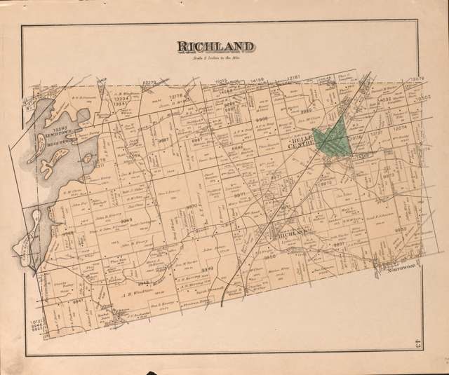
Photo: D. J. Lake & Co.; J. M. Lathrop; Library of Congress Geography and Map Division, public domain · Wikimedia Commons
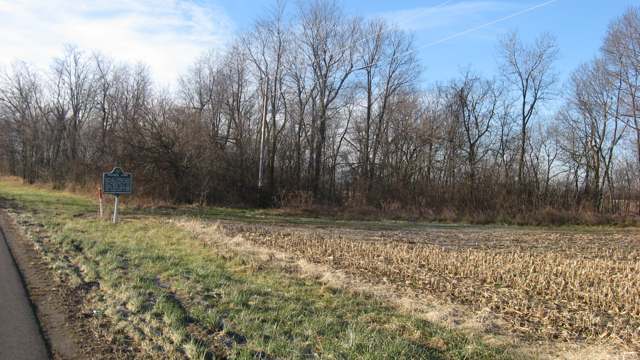
Photo: Nyttend (Wikimedia Commons), public domain · Wikimedia Commons
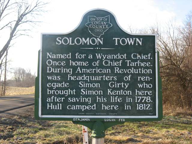
Photo: Nyttend (Wikimedia Commons), public domain · Wikimedia Commons
Local history sources: en.wikipedia.org · loganhistory.org · archive.org · archive.org · archive.org · archive.org · archive.org · archive.org · archive.org · archive.org · archive.org · archive.org · archive.org · archive.org · archive.org · archive.org · archive.org · commons.wikimedia.org · commons.wikimedia.org · commons.wikimedia.org
Water
Mostly private wells The water here
- Belle Center Village96% of residentsGroundwater wells (2 wells)
- Sci Lakeridge Estates, Llc2% of residentsGroundwater wells (2 wells)
- Tammis Mobile Village Ltd.2% of residentsGroundwater wells (2 wells)
Hospitals, fire stations and more
Inside Richland Township, Logan County's boundary: 2 spill cases. Press a pin or a name for its whole record and its source.
Spills reported since 2021 (2)
-
Fuel Diesel / Diesel Fuel (Vehicle On Or Off Road)2025-02-15 · Richland Twp
- Reported
- 2025-02-15
- What spilled
- Fuel Diesel / Diesel Fuel (Vehicle On Or Off Road)
- Largest amount reported
- 75 gallons
- Where
- Richland Twp, Logan County
- Ohio EPA district office
- SWDO
- Ohio EPA case number
- 2502EPA0000199
Ohio EPA spill reports (source) ↗ Street map and directions ↗
-
Sewage Human Reached water2023-01-13 · Richland Twp
- Reported
- 2023-01-13
- What spilled
- Sewage Human
- Reached a waterway
- Indian Creek
- Where
- Richland Twp, Logan County
- Ohio EPA district office
- SWDO
- Ohio EPA case number
- 2301EPA0000072
Ohio EPA spill reports (source) ↗ Street map and directions ↗
Source: Ohio EPA emergency response spill reports, 2021 to September 2026, one point per case where Ohio EPA placed it. A report is what the caller or responder recorded; amounts are often blank or estimated.
Its ZIP codes
Each ZIP code that touches Richland Township, Logan County, with the share of its residents who live here and the same headline figures as the ZIP page.
| ZIP | Share | Water | Radon | Home value | Schools | Flood |
|---|---|---|---|---|---|---|
| 43310 Richland Township and Belle Center | 43% | Mostly private wells | 3.9 pCi/L average radon | Median year built 1972 | Benjamin Logan Local · 4 stars overall | 5.7% of residents in the 1% floodplain |
| 43324 Mcarthur Township and Huntsville | 17% | Mostly private wells | 3.9 pCi/L average radon | Median year built 1973 | Indian Lake Local · 4 stars overall | 2.9% of residents in the 1% floodplain |
Local government
Who holds office in Richland Township, Logan County, how its elections and ballot issues came out, and the state auditor's record.
Elections for office
| Date | Office | Candidates and votes |
|---|---|---|
| 2024-11-05 | Township Trustee | Matthew W. Hurley 839, 63.27%; Kenneth Rogers 487, 36.73% |
| 2023-11-07 | Township Trustee (unofficial count) | Tracy M. Baker 731, 100.0% |
| 2023-11-07 | Township Fiscal Officer (unofficial count) | Cathy Pool 711, 100.0% |
| 2021-11-02 | Township Trustee | Gary Carson 290, 36.66%; Greg Fitzpatrick 324, 40.96%; Matt Hurley 177, 22.38% |
| 2019-11-05 | Township Trustee | Tracy M. Baker 494, 100.0% |
| 2019-11-05 | Township Fiscal Officer | Cathy Pool 333, 57.12%; Jeff Rose 250, 42.88% |
Winners in bold. Results from the county board of elections' official canvass unless marked.
Auditor of State record
- No fiscal caution, watch or emergency on the Auditor of State's lists.
- Financial Audit, 2023 to 2024, released 2026-01-13
The county
Logan County: 14 ZIP codes, 33 cities, villages and townships, 49,613 people.
Nearby places
Quick answers
What county is Richland Township, Ohio in?
Richland Township, Logan County is a township in Logan County, Ohio, with 1,836 residents.
When was Richland Township, Ohio founded?
Richland Township, Logan County was settled 1817; incorporated 1844 (Wikipedia and the 1880 county table) or December 1845 (commissioners' order and first election, per the 1880 township chapter). Founders on record: Logan County commissioners, from the part of McArthur Township north of the south line of the Solomon's Town survey. Source
What ZIP code is Richland Township, Ohio?
Richland Township, Logan County is served by ZIP codes 43310 and 43324; 43310 holds the largest share of its residents.
Where does Richland Township, Ohio get its water?
The main water source for Richland Township, Logan County (Belle Center Village): Mostly private wells.
Cite this page
Cite this page as:
Cracked Buckeye, "Richland Township, Logan County", https://crackedbuckeye.com/place/richland-township-logan-county/, built 2026-10-31, accessed [date].
How to cite · Report a correction · Built 2026-10-31
