Local events in Mcarthur Township, Logan County
Nothing is posted for Mcarthur Township itself yet; here is what is on within 10 miles. All local events in Mcarthur Township, Logan County
Know a calendar we should watch? Send the link
Checked October 20; the events page is refreshed daily.
How Mcarthur Township, Logan County began
McArthur Township lies in the north-central part of Logan County and was organized in 1823 (the date comes from a county table; the township's early records were destroyed), named for Duncan McArthur, the Ohio surveyor, War of 1812 general and later governor, who owned large tracts here and sold the first land in 1820. Settlers came from 1814 and especially from 1820 along Cherokee Man's Run; the stage village of Cherokee, laid out in 1832, flourished as a relay on the Springfield-Sandusky line until the Mad River and Lake Erie Railroad passed a mile away and the new village of Huntsville, platted in 1846 by surveyor Aaron L. Hunt, took its trade. At Northwood, on the township's north line, the Reformed Presbyterians founded Geneva Hall in 1848 (the college moved to Beaver Falls, Pennsylvania, in 1880), and the township was a station on the Underground Railroad. Huntsville, incorporated in December 1865, later grew around Toledo and Ohio Central Railway shops; the township remains farm country with 1,920 residents at the 2020 census.
Settled 1814 (Peter Stamats; the 1880 township chapter names Thomas Scott, who came in 1820, first); steady settlement from 1820, platted 1832 (Cherokee and Northwood); 1846 (Huntsville), incorporated 1823 (township organized, per a county table; the early records were destroyed); December 1865 (Huntsville village), by Aaron L. Hunt (Huntsville plat).
Where the name comes from
McArthur Township is named for Duncan McArthur (1772-1839), an Ohio surveyor, War of 1812 general, congressman and governor; it is the only township of that name in Ohio. Its village, Huntsville, is named for Aaron L. Hunt, the government surveyor who platted it in 1846.
Before the town
The 1903 county history describes McArthur Township as lying in the middle of country the Native people held as hunting ground, between the Mac-a-cheek towns on the Mad River and the Wyandot town of Solomon's Town just to the north, and near the town of the Lenape (Delaware) chief Buckongehelas. Before the Shawnee and Seneca were gathered on the Lewistown reservation, the 1880 history says, small parties lived scattered through the township, leaving clearings of an acre or two dotted with stumps. Rev. James Wallace, first pastor of the United Presbyterian church organized here in 1831, recalled a body of Native people still living in and about Lewistown, a few miles west of the church. The 1880 history also repeats a tradition that two soldiers sleeping at the Twin Springs, Hull's encampment of 1812, were killed by Native warriors, and Antrim's account that Captain Arthur Thomas and his son were killed and scalped near the Big Spring by Solomon's Town while hunting stray horses during the war.
Nations recorded here: Shawnee, Seneca, Wyandot, Lenape (Delaware).
- Native clearings (other) — scattered through McArthur Township before the Lewistown reservation was formed, before 1817 (archive.org)
Timeline
- — A camp meeting led by Rev. Thomas H. Wilson on Cherokee Man's Run, south of the later Huntsville, drew settlers for many miles and produced hundreds of conversions.
- — General William Hull's army, marching toward Detroit, camped just north of the later Cherokee at the twin springs, a place long afterward called Hull's encampment.
- — Peter Stamats of Pennsylvania made the first settlement and first land purchase in the township, according to both county histories, though the 1880 history's township chapter names Thomas Scott, who came in 1820, first.
- — On November 9 Duncan McArthur sold 450 acres on Cherokee Man's Run to John and Samuel Harrod for $932, among the first land sales in the township; Thomas Scott's family had settled that spring and the Harrods came that fall.
- — McArthur Township was organized within Logan County.
- — A Methodist class was formed at Solomon Richards's cabin half a mile southwest of the later Cherokee, the township's first religious society.
- — President James Monroe issued a patent to Joseph Carter of Richmond, Virginia, for 1,000 acres adjoining the Solomon's Town block and including Hull's encampment; Adcock Carter settled on it in 1827.
- — About this year Adam Yearn built the township's first grist mill, a frame mill with one run of stone on Cherokee Creek half a mile southeast of the later Huntsville.
- — In October Rev. S. Wilson organized the Associate (later United Presbyterian) congregation; Rev. James Wallace became its first pastor and served until his health failed.
- — On March 19 Robert Edminston, Dr. Samuel A. Morton and Alexander Thompson laid out Cherokee, which became a relay point of the Springfield and Sandusky stage line.
- — A post office was established at Cherokee, operating until 1849 (the 1880 history dates it about 1830).
- — On May 12 County Surveyor James W. Marmon platted Northwood on land of Joseph Wilmuth, on the township's north line.
- — In September Revs. Dobbins and Roberson organized the Cherokee Presbyterian Church, the first church of the Calvinistic order formed in Logan County; its building was later moved to Huntsville.
- — Rev. J. B. Johnston formed the Miami congregation of the Reformed Presbyterian Church at Northwood and built a log church on the east bank of the Miami River.
- — Huntsville was platted by government surveyor Aaron L. Hunt.
- — Rev. John Black Johnston founded Geneva Hall at Northwood, after teaching a first class in his study in 1847.
- — About this year the post office was moved from Cherokee to Huntsville, as churches and business followed the railroad.
- — J. R. W. Sloane was inaugurated president of the college at Northwood and a full course of study adopted; he resigned in 1856.
- — The United Presbyterian congregation of Northwood was organized on June 14 and met in the chapel of Geneva Hall until its own church was finished in 1866.
- — Huntsville was incorporated as a village.
- — Huntsville had 430 residents, three churches and one school, a gain of 30 percent in ten years; the Reformed Presbyterian Synod was moving the college at Northwood to Beaver Falls, Pennsylvania.
- — Henry Howe described Huntsville as six miles north of Bellefontaine on the Indiana, Bloomington and Western Railroad, with three churches, 429 residents in 1880 and a school census of 216 in 1888.
- — Toledo and Ohio Central Railway service through Huntsville was abandoned in stages: the Bellefontaine-to-East Liberty segment in the 1960s, and the remaining Saint Marys-to-Bellefontaine trackage in the 1970s following Penn Central's bankruptcy.
Stories
A railroad town's rise and quiet decline
Huntsville, the village at the center of McArthur Township, was platted in 1846 by government surveyor Aaron L. Hunt and grew up along what became the Toledo and Ohio Central Railway, a line that ran from St. Marys through Russells Point toward East Liberty and on to Columbus. For decades the railroad kept locomotive repair facilities in the village, giving Huntsville an outsized role in local rail traffic for its size. That role faded in the twentieth century: the Bellefontaine-to-East Liberty stretch of track was abandoned in the 1960s, and the last trackage between St. Marys and Bellefontaine was pulled up in the 1970s after the Penn Central railroad's bankruptcy left the branch unprofitable to maintain. Huntsville's population has stayed small and stable since, 408 residents at the 2020 census, a farm-country village that outlived the railroad that once ran through it.
Cherokee died in a single night
Cherokee was laid out in 1832 and became a thriving center of business on the stage route from Springfield to Sandusky, with two hotels and half a dozen stores, three blacksmith shops and two wagon makers. When the Mad River and Lake Erie Railroad was located, the 1903 county history says, Cherokee was an independent village whose people would lend no help toward building the road, believing it must come to their town anyway. The railroad men were just as independent and located the line a mile away. In the history's words, Cherokee died in a single night, and Huntsville sprang into existence like Jonah's gourd. For many years almost all that was left of Cherokee was Kemp Carter's hotel, where young people went for dancing.
Geneva Hall at Northwood
Rev. J. B. Johnston, pastor of the Reformed Presbyterian congregation at Northwood, began a class in his study in 1847. The next year funds were raised for a small brick building, which was soon enlarged into the college hall; a female department with its own brick building and two boarding halls followed. In 1852 J. R. W. Sloane became president, with a faculty and a full course of study, and served four years. The school then ran as an academy until 1864, when the Reformed Presbyterian Synod bought it; S. J. Crowe, W. Milroy and H. H. George served as presidents from 1867. In 1880 the Synod decided to move the college to Beaver Falls, Pennsylvania, where it continues as Geneva College, and a normal school was proposed for the old buildings at Northwood.
Photographs
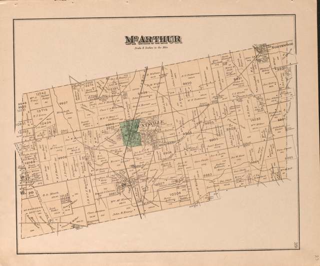
Photo: D. J. Lake & Co.; J. M. Lathrop; Library of Congress Geography and Map Division, public domain · Wikimedia Commons
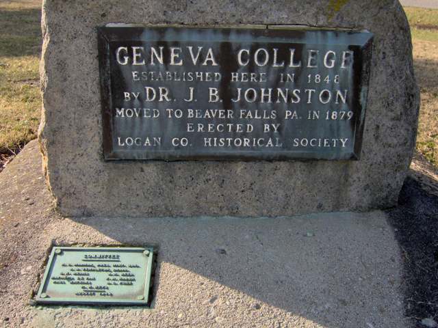
Photo: Nyttend (Wikimedia Commons), public domain · Wikimedia Commons
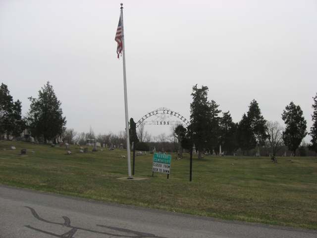
Photo: Nyttend (Wikimedia Commons), public domain · Wikimedia Commons
Photo: Nyttend (Wikimedia Commons), public domain · Wikimedia Commons
Local history sources: en.wikipedia.org · en.wikipedia.org · en.wikipedia.org · en.wikipedia.org · archive.org · archive.org · archive.org · archive.org · archive.org · archive.org · archive.org · archive.org · archive.org · archive.org · archive.org · archive.org · archive.org · archive.org · commons.wikimedia.org · commons.wikimedia.org · commons.wikimedia.org · commons.wikimedia.org
Water
Mostly private wells The water here
- Bellefontaine City88% of residentslocal wells (shallow carbonate aquifer)
- Sci Lakeridge Estates, Llc8% of residentsGroundwater wells (2 wells)
- Belle Center Village3% of residentsGroundwater wells (2 wells)
- Tammis Mobile Village Ltd.0% of residentsGroundwater wells (2 wells)
Hospitals, fire stations and more
Inside Mcarthur Township, Logan County's boundary: 6 spill cases. Press a pin or a name for its whole record and its source.
Spills reported since 2021 (6)
-
Fuel Diesel / Diesel Fuel (Vehicle On Or Off Road)2024-03-27 · Mcarthur Twp
- Reported
- 2024-03-27
- What spilled
- Fuel Diesel / Diesel Fuel (Vehicle On Or Off Road); Oil Motor / Lube Oil / Vehicle
- Largest amount reported
- 100 gallons
- Where
- Mcarthur Twp, Logan County
- Ohio EPA district office
- SWDO
- Ohio EPA case number
- 2403EPA0000478
Ohio EPA spill reports (source) ↗ Street map and directions ↗
-
Other / All Other / Trade Name / Mixture / Solution Etc2023-12-02 · York Twp
- Reported
- 2023-12-02
- What spilled
- Other / All Other / Trade Name / Mixture / Solution Etc
- Where
- York Twp, Union County
- Ohio EPA district office
- SWDO
- Ohio EPA case number
- 2312EPA0002005
Ohio EPA spill reports (source) ↗ Street map and directions ↗
-
Fuel Diesel / Diesel Fuel (Vehicle On Or Off Road)2022-12-17 · Mcarthur Twp
- Reported
- 2022-12-17
- What spilled
- Fuel Diesel / Diesel Fuel (Vehicle On Or Off Road)
- Where
- Mcarthur Twp, Logan County
- Ohio EPA district office
- SWDO
- Ohio EPA case number
- 2212EPA0001873
Ohio EPA spill reports (source) ↗ Street map and directions ↗
-
Fuel Diesel / Diesel Fuel (Vehicle On Or Off Road)2021-12-16 · Mcarthur Twp
- Reported
- 2021-12-16
- What spilled
- Fuel Diesel / Diesel Fuel (Vehicle On Or Off Road)
- Largest amount reported
- 60 gallons
- Where
- Mcarthur Twp, Logan County
- Ohio EPA district office
- SWDO
- Ohio EPA case number
- 2112EPA0001869
Ohio EPA spill reports (source) ↗ Street map and directions ↗
-
Fuel Diesel / Diesel Fuel (Vehicle On Or Off Road)2021-05-28 · Mcarthur Twp
- Reported
- 2021-05-28
- What spilled
- Fuel Diesel / Diesel Fuel (Vehicle On Or Off Road)
- Largest amount reported
- 20 gallons
- Where
- Mcarthur Twp, Logan County
- Ohio EPA district office
- SWDO
- Ohio EPA case number
- 2105EPA0000756
Ohio EPA spill reports (source) ↗ Street map and directions ↗
-
Fuel Diesel / Diesel Fuel (Vehicle On Or Off Road)2026-05-15 · Mcarthur Twp
- Reported
- 2026-05-15
- What spilled
- Fuel Diesel / Diesel Fuel (Vehicle On Or Off Road)
- Largest amount reported
- 45 gallons
- Where
- Mcarthur Twp, Logan County
- Ohio EPA district office
- SWDO
- Ohio EPA case number
- 2605EPA0000812
Ohio EPA spill reports (source) ↗ Street map and directions ↗
Source: Ohio EPA emergency response spill reports, 2021 to September 2026, one point per case where Ohio EPA placed it. A report is what the caller or responder recorded; amounts are often blank or estimated.
Its ZIP codes
Each ZIP code that touches Mcarthur Township, Logan County, with the share of its residents who live here and the same headline figures as the ZIP page.
| ZIP | Share | Water | Radon | Home value | Schools | Flood |
|---|---|---|---|---|---|---|
| 43324 Mcarthur Township and Huntsville | 43% | Mostly private wells | 3.9 pCi/L average radon | Median year built 1973 | Indian Lake Local · 4 stars overall | 2.9% of residents in the 1% floodplain |
| 43311 Bellefontaine | 2% | local wells (shallow carbonate aquifer) | 6.9 pCi/L average radon | Median year built 1963 | Bellefontaine City · 3.5 stars overall | 2.7% of residents in the 1% floodplain |
| 43310 Richland Township and Belle Center | 1% | Mostly private wells | 3.9 pCi/L average radon | Median year built 1972 | Benjamin Logan Local · 4 stars overall | 5.7% of residents in the 1% floodplain |
Local government
Who holds office in Mcarthur Township, Logan County, how its elections and ballot issues came out, and the state auditor's record.
Money issues on the ballot since 2020: 2 of 2 passed.
Ballot issues
| Date | Issue | For | Against | Result |
|---|---|---|---|---|
| 2023-11-07 | Issue: McArthur Township (excl Huntsville) Fire Renewal | 399 | 188 | Passed (67.97% for), unofficial |
| 2020-11-03 | Issue: McArthur Township Fire Renewal Levy (excluding Huntsville) | 590 | 271 | Passed (68.52% for) |
Elections for office
| Date | Office | Candidates and votes |
|---|---|---|
| 2023-11-07 | Township Trustee (unofficial count) | D. William Volbrecht 524, 100.0% |
| 2023-11-07 | Township Fiscal Officer (unofficial count) | Brandi R. Altstaetter 538, 100.0% |
| 2021-11-02 | Township Trustee | D. John Cummins 168, 30.05%; J. Andy Forsythe 167, 29.87%; G. Russel Hurley 224, 40.07% |
| 2021-11-02 | Township Trustee | D. Willy Volbrecht 263, 100.0% |
| 2019-11-05 | Township Trustee | D. Bruce Tracey 220, 100.0% |
| 2019-11-05 | Township Fiscal Officer | Brandi R. Altstaetter 218, 100.0% |
Winners in bold. Results from the county board of elections' official canvass unless marked.
The county
Logan County: 14 ZIP codes, 33 cities, villages and townships, 49,613 people.
Nearby places
Quick answers
What county is Mcarthur Township, Ohio in?
Mcarthur Township, Logan County is a township in Logan County, Ohio, with 1,512 residents.
When was Mcarthur Township, Ohio founded?
Mcarthur Township, Logan County was settled 1814 (Peter Stamats; the 1880 township chapter names Thomas Scott, who came in 1820, first); steady settlement from 1820; laid out 1832 (Cherokee and Northwood); 1846 (Huntsville); incorporated 1823 (township organized, per a county table; the early records were destroyed); December 1865 (Huntsville village). Founders on record: Aaron L. Hunt (Huntsville plat). Source
How did Mcarthur Township, Ohio get its name?
McArthur Township is named for Duncan McArthur (1772-1839), an Ohio surveyor, War of 1812 general, congressman and governor; it is the only township of that name in Ohio. Source
What ZIP code is Mcarthur Township, Ohio?
Most of Mcarthur Township, Logan County is in ZIP code 43324.
Where does Mcarthur Township, Ohio get its water?
The main water source for Mcarthur Township, Logan County (Bellefontaine City): Mostly private wells.
Cite this page
Cite this page as:
Cracked Buckeye, "Mcarthur Township, Logan County", https://crackedbuckeye.com/place/mcarthur-township-logan-county/, built 2026-10-31, accessed [date].
How to cite · Report a correction · Built 2026-10-31
