Local events in Portsmouth
54 events in the next 90 days from 6 public calendars. All local events in Portsmouth
Checked October 20; the events page is refreshed daily.
Lakes near Portsmouth
The history under the water: the valley before, the dam, the stories. All Ohio lakes
Deep dives about Portsmouth
Long reads built from maps, newspapers and public records. All deep dives
- Ohio's Native Nations, 1650-1843Ohio's historic Native nations were mostly newcomers of the 1720s-1750s, not ancient residents, and by 1843 every one had been forced out of the state.
- The Hopewell CultureOhio's Hopewell people built moon-aligned earthworks around AD 90-430, moved Yellowstone obsidian 1,500 miles, and left a 2023 UNESCO World Heritage Site.
- The Mound Builder MythOhio's earthworks were long blamed on a vanished 'lost race,' a myth that helped justify Indian Removal and outlived its 1894 federal debunking.
How Portsmouth began
Portsmouth was platted in 1803 by Henry Massie on ground set back from the Scioto-Ohio confluence, replacing an earlier river-bottom settlement, Alexandria, that had proved too flood-prone; Massie named the new town for Portsmouth, New Hampshire, and it became Scioto County's seat from the start, incorporated as a city in 1815. Canals, then railroads, built it into a manufacturing center that by 1916 was the nation's fourth-largest producer of shoes and its largest maker of fire and paving brick, and from 1930 to 1933 the city fielded its own NFL franchise, the Portsmouth Spartans. Ohio River floods, especially the catastrophic 1937 flood, forced the Army Corps of Engineers to wall the city off from its own waterfront, and the closure of steel and shoe plants after 1970 ended its industrial peak; Portsmouth's population, near 42,000 in 1930, is about 18,000 today.
Settled 1790s (as Alexandria, a river-bottom settlement since vanished), platted 1803, incorporated 1815, by Henry Massie.
Where the name comes from
Henry Massie, the town's founder, named it for Portsmouth, New Hampshire.
Before the town
Portsmouth sits directly on top of Scioto County's two most significant Native sites: the Portsmouth Earthworks, a large Adena and Hopewell ceremonial complex (c. 100 BC – AD 500) surveyed by Squier and Davis in 1847 and now almost entirely covered by the city except for one enclosure preserved as Mound Park; and Lower Shawneetown, a major Shawnee-led town of over a thousand people that stood on both banks of the Ohio at the Scioto's mouth from about 1734 until its people abandoned it in November 1758 during the French and Indian War. The city's modern floodwall carries a mural series, begun in 1992, depicting local history including Lower Shawneetown. Nothing beyond these two sites was found specific to the platted city itself.
Nations recorded here: Shawnee, Adena culture, Hopewell culture.
- Portsmouth Earthworks (Mound Park remnant) (earthwork) — Portsmouth, at the mouth of the Scioto River, Adena and Hopewell, c. 100 BC – AD 500 (en.wikipedia.org)
- Lower Shawneetown (village) — both banks of the Ohio River at the Scioto's mouth, in and around modern Portsmouth, c. 1734 – November 1758 (en.wikipedia.org)
Timeline
- — Emanuel Traxler becomes the first person of European descent to settle permanently on the future townsite.
- — Henry Massie plats Portsmouth on high ground east of the failed river-bottom settlement of Alexandria; the new town becomes Scioto County's seat.
- — Portsmouth is incorporated as a city.
- — Construction begins on Norfolk and Western railyards in Portsmouth, cementing the city's role as a rail hub.
- — An Ohio River flood swamps Portsmouth's waterfront; the steamer Bonanza is photographed working the inundated levee.
- — A major Ohio River flood devastates the city; a sixteen-photograph souvenir set documents the damage.
- — Portsmouth ranks as the nation's fourth-largest shoe-manufacturing center and its largest producer of fire and paving brick.
- — The Portsmouth Spartans are organized from defunct local semi-professional teams; the club joins the NFL in 1930 and compiles a 28-16-7 record before being sold and relocated to Detroit as the Lions in 1934.
- — The city's population peaks at just over 42,000.
- — The Ohio River flood of 1937 overwhelms the city's defenses and inundates much of Portsmouth, prompting the Army Corps of Engineers to build the floodwalls that protect it today.
- — Closure of the Empire Detroit Steel plant eliminates about 1,300 steelworking jobs.
Stories
A city that outgrew its own football team
In 1928, players from a handful of defunct local semi-professional clubs regrouped in Portsmouth — then a city of barely 40,000 — as the Portsmouth Spartans, and by 1930 the team had joined the National Football League. It was a serious club: an 11-3 record in 1931, a 19-0 "iron man" win over Green Bay in 1932 in which coach Potsy Clark used only eleven players for the entire game, and the league's first-ever playoff game that December, a 9-0 loss to the Chicago Bears decided indoors at the Chicago Stadium after a blizzard. None of it paid the bills. Players took shares in the team instead of full salaries, and after the 1933 season, with a combined winning percentage in its last three years second only to the Bears' own, the franchise was sold to Detroit radio executive George A. Richards, who renamed it the Lions for 1934. Portsmouth remains, by a wide margin, the smallest market ever to have hosted an NFL franchise for multiple seasons.
Shoes, brick, and a wall against the river
By 1916 Portsmouth stood as the fourth-largest shoe-manufacturing city in the United States and the country's largest maker of fire and paving brick, its factories fed by rail lines that had reached the city as early as 1838 and a river that had made it a trading point since Henry Massie's first plat in 1803. That same river turned on the city again and again — floods in 1884, 1913, and, catastrophically, 1937, when the Ohio River crested high enough to inundate most of Portsmouth despite its levees. The 1937 flood finally forced the U.S. Army Corps of Engineers to wall the city off from its own waterfront; those floodwalls have held ever since, and since 1992 they have carried a growing series of murals that turn the barrier itself into a record of the city's history, including scenes of the Shawnee town that once stood on the same ground.
Photographs
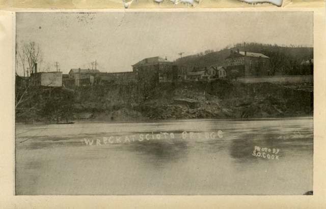
Photo: Columbus Metropolitan Library, via Digital Public Library of America, no known copyright restrictions · Wikimedia Commons
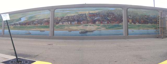
Photo: Chris Light, Wikimedia Commons, CC BY-SA 4.0 · Wikimedia Commons
Local history sources: en.wikipedia.org · en.wikipedia.org · en.wikipedia.org · en.wikipedia.org · commons.wikimedia.org
Historic places
32 places in Portsmouth on the National Register of Historic Places. Press a pin or a name for its whole record.
-
All Saints Episcopal ChurchBuilding · Portsmouth · listed 1982
- Address
- 4th and Court Sts.
- Where
- Portsmouth, Scioto County · ZIP 45662
- What it is
- Building
- Listed on the National Register
- 1982
- NRIS reference number
- 82003639
- Coordinates
- 38.73298, -83.00030
National Register file (NPS) ↗ Search Wikipedia ↗ Street map and directions ↗ On the Cracked Buckeye map
-
Anderson Brothers Department StoreBuilding · Portsmouth · listed 2001
- Address
- 301-307 Chillicothe St.
- Where
- Portsmouth, Scioto County · ZIP 45662
- What it is
- Building
- Listed on the National Register
- 2001
- NRIS reference number
- 01000052
- Coordinates
- 38.73241, -82.99683
National Register file (NPS) ↗ Search Wikipedia ↗ Street map and directions ↗ On the Cracked Buckeye map
-
Bigelow United Methodist ChurchBuilding · Portsmouth · listed 1987
- Address
- 415 Washington St.
- Where
- Portsmouth, Scioto County · ZIP 45662
- What it is
- Building
- Listed on the National Register
- 1987
- NRIS reference number
- 87002073
- Coordinates
- 38.73391, -82.99912
National Register file (NPS) ↗ Search Wikipedia ↗ Street map and directions ↗ On the Cracked Buckeye map
-
Cunningham--Maier HouseBuilding · Portsmouth · listed 1987
- Address
- 506 Sixth
- Where
- Portsmouth, Scioto County · ZIP 45662
- What it is
- Building
- Listed on the National Register
- 1987
- NRIS reference number
- 87002074
- Coordinates
- 38.73470, -83.00265
National Register file (NPS) ↗ Search Wikipedia ↗ Street map and directions ↗ On the Cracked Buckeye map
-
Dole-Darrell HouseBuilding · Portsmouth · listed 1987
- Address
- 322 Market St.
- Where
- Portsmouth, Scioto County · ZIP 45662
- What it is
- Building
- Listed on the National Register
- 1987
- NRIS reference number
- 87002075
- Coordinates
- 38.73303, -83.00260
National Register file (NPS) ↗ Search Wikipedia ↗ Street map and directions ↗ On the Cracked Buckeye map
-
Elden HouseBuilding · Portsmouth · listed 1987
- Address
- 634 Fourth St.
- Where
- Portsmouth, Scioto County · ZIP 45662
- What it is
- Building
- Listed on the National Register
- 1987
- NRIS reference number
- 87002076
- Coordinates
- 38.73323, -83.00192
National Register file (NPS) ↗ Search Wikipedia ↗ Street map and directions ↗ On the Cracked Buckeye map
-
Eugene McKinley Memorial PoolStructure · Portsmouth
- Address
- 1529 Findlay Street
- Where
- Portsmouth, Scioto County · ZIP 45662
- What it is
- Structure
- Latest NPS certification action
- 2019
- NRIS reference number
- 100004233
- Coordinates
- 38.74336, -82.99290
National Register file (NPS) ↗ Search Wikipedia ↗ Street map and directions ↗ On the Cracked Buckeye map
-
Evangelical Church of ChristBuilding · Portsmouth · listed 1987
- Address
- 701 Fifth St.
- Where
- Portsmouth, Scioto County · ZIP 45662
- What it is
- Building
- Listed on the National Register
- 1987
- NRIS reference number
- 87002077
- Coordinates
- 38.73437, -82.99833
National Register file (NPS) ↗ Search Wikipedia ↗ Street map and directions ↗ On the Cracked Buckeye map
-
First Presbyterian ChurchBuilding · Portsmouth · listed 1973
- Address
- 221 Court St.
- Where
- Portsmouth, Scioto County · ZIP 45662
- What it is
- Building
- Listed on the National Register
- 1973
- NRIS reference number
- 73001532
- Coordinates
- 38.73216, -83.00097
National Register file (NPS) ↗ Search Wikipedia ↗ Street map and directions ↗ On the Cracked Buckeye map
-
General U.S. Grant BridgeStructure · Portsmouth · listed 2001
- Address
- Ohio R.-Chillicothe and Second St.
- Where
- Portsmouth, Scioto County · ZIP 45662
- What it is
- Structure
- Listed on the National Register
- 2001
- NRIS reference number
- 01000559
- Coordinates
- 38.73061, -82.99678
National Register file (NPS) ↗ Search Wikipedia ↗ Street map and directions ↗ On the Cracked Buckeye map
-
Gharky, George H., HouseBuilding · Portsmouth · listed 1987
- Address
- 638 Fourth St.
- Where
- Portsmouth, Scioto County · ZIP 45662
- What it is
- Building
- Listed on the National Register
- 1987
- NRIS reference number
- 87002078
- Coordinates
- 38.73292, -82.99892
National Register file (NPS) ↗ Search Wikipedia ↗ Street map and directions ↗ On the Cracked Buckeye map
-
Greenlawn Cemetery ChapelBuilding · Portsmouth · listed 1980
- Address
- Offnere St.
- Where
- Portsmouth, Scioto County · ZIP 45662
- What it is
- Building
- Listed on the National Register
- 1980
- NRIS reference number
- 80003216
- Coordinates
- 38.74389, -82.98444
National Register file (NPS) ↗ Search Wikipedia ↗ Street map and directions ↗ On the Cracked Buckeye map
-
Horseshoe MoundSite · Portsmouth · listed 1974
- Address
- Within Mound Park
- Where
- Portsmouth, Scioto County · ZIP 45662
- What it is
- Site
- Listed on the National Register
- 1974
- NRIS reference number
- 74001621
- Coordinates
- 38.74329, -82.97700
National Register file (NPS) ↗ Search Wikipedia ↗ Street map and directions ↗ On the Cracked Buckeye map
-
Hurth HotelBuilding · Portsmouth · listed 1983
- Address
- 222 Chillicothe St.
- Where
- Portsmouth, Scioto County · ZIP 45662
- What it is
- Building
- Listed on the National Register
- 1983
- NRIS reference number
- 83002056
- Coordinates
- 38.73206, -82.99659
National Register file (NPS) ↗ Search Wikipedia ↗ Street map and directions ↗ On the Cracked Buckeye map
-
Kinney, Aaron, HouseBuilding · Portsmouth · listed 1973
- Address
- Waller St.
- Where
- Portsmouth, Scioto County · ZIP 45662
- What it is
- Building
- Listed on the National Register
- 1973
- NRIS reference number
- 73001533
- Coordinates
- 38.74751, -82.98851
National Register file (NPS) ↗ Search Wikipedia ↗ Street map and directions ↗ On the Cracked Buckeye map
-
Kinney, Eli, HouseBuilding · Portsmouth · listed 1988
- Address
- 317 Court St.
- Where
- Portsmouth, Scioto County · ZIP 45662
- What it is
- Building
- Listed on the National Register
- 1988
- NRIS reference number
- 87002079
- Coordinates
- 38.73306, -83.00088
National Register file (NPS) ↗ Search Wikipedia ↗ Street map and directions ↗ On the Cracked Buckeye map
-
Labold House and GardensBuilding · Portsmouth · listed 1987
- Address
- 633 Fourth St.
- Where
- Portsmouth, Scioto County · ZIP 45662
- What it is
- Building
- Listed on the National Register
- 1987
- NRIS reference number
- 87002085
- Coordinates
- 38.73328, -82.99870
National Register file (NPS) ↗ Search Wikipedia ↗ Street map and directions ↗ On the Cracked Buckeye map
-
Marsh, Joseph, HouseBuilding · Portsmouth · listed 1987
- Address
- 701 Market St.
- Where
- Portsmouth, Scioto County · ZIP 45662
- What it is
- Building
- Listed on the National Register
- 1987
- NRIS reference number
- 87002087
- Coordinates
- 38.73573, -83.00297
National Register file (NPS) ↗ Search Wikipedia ↗ Street map and directions ↗ On the Cracked Buckeye map
-
Meyer HouseBuilding · Portsmouth · listed 1988
- Address
- 309 Washington St.
- Where
- Portsmouth, Scioto County · ZIP 45662
- What it is
- Building
- Listed on the National Register
- 1988
- NRIS reference number
- 87002088
- Coordinates
- 38.73301, -82.99881
National Register file (NPS) ↗ Search Wikipedia ↗ Street map and directions ↗ On the Cracked Buckeye map
-
Newman, William, HouseBuilding · Portsmouth · listed 1987
- Address
- 716 Second St.
- Where
- Portsmouth, Scioto County · ZIP 45662
- What it is
- Building
- Listed on the National Register
- 1987
- NRIS reference number
- 87002089
- Coordinates
- 38.73153, -82.99819
National Register file (NPS) ↗ Search Wikipedia ↗ Street map and directions ↗ On the Cracked Buckeye map
-
Odd Fellows HallBuilding · Portsmouth · listed 1987
- Address
- 500--506 Court St.
- Where
- Portsmouth, Scioto County · ZIP 45662
- What it is
- Building
- Listed on the National Register
- 1987
- NRIS reference number
- 87002090
- Coordinates
- 38.73415, -83.00033
National Register file (NPS) ↗ Search Wikipedia ↗ Street map and directions ↗ On the Cracked Buckeye map
-
Peck, Judge William V., HouseBuilding · Portsmouth · listed 1979
- Address
- 601 Market St
- Where
- Portsmouth, Scioto County · ZIP 45662
- What it is
- Building
- Listed on the National Register
- 1979
- NRIS reference number
- 79001939
- Coordinates
- 38.73438, -83.00299
National Register file (NPS) ↗ Search Wikipedia ↗ Street map and directions ↗ On the Cracked Buckeye map
-
Portsmouth Fire Department No. 1Building · Portsmouth · listed 1987
- Address
- 642 Seventh St.
- Where
- Portsmouth, Scioto County · ZIP 45662
- What it is
- Building
- Listed on the National Register
- 1987
- NRIS reference number
- 87002091
- Coordinates
- 38.73553, -82.99876
National Register file (NPS) ↗ Search Wikipedia ↗ Street map and directions ↗ On the Cracked Buckeye map
-
Portsmouth Foundry and Machine WorksBuilding · Portsmouth · listed 1987
- Address
- 401 Third St.
- Where
- Portsmouth, Scioto County · ZIP 45662
- What it is
- Building
- Listed on the National Register
- 1987
- NRIS reference number
- 87002095
- Coordinates
- 38.73272, -83.00495
National Register file (NPS) ↗ Search Wikipedia ↗ Street map and directions ↗ On the Cracked Buckeye map
-
Purdum--Tracy HouseBuilding · Portsmouth · listed 1987
- Address
- 626 Fourth St.
- Where
- Portsmouth, Scioto County · ZIP 45662
- What it is
- Building
- Listed on the National Register
- 1987
- NRIS reference number
- 87002097
- Coordinates
- 38.73318, -82.99939
National Register file (NPS) ↗ Search Wikipedia ↗ Street map and directions ↗ On the Cracked Buckeye map
-
Reed, Joseph G., CompanyBuilding · Portsmouth · listed 1987
- Address
- 700 Second St.
- Where
- Portsmouth, Scioto County · ZIP 45662
- What it is
- Building
- Listed on the National Register
- 1987
- NRIS reference number
- 87002099
- Coordinates
- 38.73148, -82.99888
National Register file (NPS) ↗ Search Wikipedia ↗ Street map and directions ↗ On the Cracked Buckeye map
-
Scioto County CourthouseBuilding · Portsmouth · listed 1987
- Address
- Bounded by Seventh, Court, Sixth, & Washington Sts.
- Where
- Portsmouth, Scioto County · ZIP 45662
- What it is
- Building
- Listed on the National Register
- 1987
- NRIS reference number
- 87002101
- Coordinates
- 38.73524, -83.00013
National Register file (NPS) ↗ Search Wikipedia ↗ Street map and directions ↗ On the Cracked Buckeye map
-
Second Presbyterian ChurchBuilding · Portsmouth · listed 1996
- Address
- 801 Waller St.
- Where
- Portsmouth, Scioto County · ZIP 45662
- What it is
- Building
- Listed on the National Register
- 1996
- NRIS reference number
- 96000926
- Coordinates
- 38.73641, -82.98958
National Register file (NPS) ↗ Search Wikipedia ↗ Street map and directions ↗ On the Cracked Buckeye map
-
St. Mary's Roman Catholic ChurchBuilding · Portsmouth · listed 1979
- Address
- 5th and Markets Sts
- Where
- Portsmouth, Scioto County · ZIP 45662
- What it is
- Building
- Listed on the National Register
- 1979
- NRIS reference number
- 79001940
- Coordinates
- 38.73430, -83.00218
National Register file (NPS) ↗ Search Wikipedia ↗ Street map and directions ↗ On the Cracked Buckeye map
-
Steindam HouseBuilding · Portsmouth · listed 1987
- Address
- 725 Court St.
- Where
- Portsmouth, Scioto County · ZIP 45662
- What it is
- Building
- Listed on the National Register
- 1987
- NRIS reference number
- 87002104
- Coordinates
- 38.73631, -83.00085
National Register file (NPS) ↗ Search Wikipedia ↗ Street map and directions ↗ On the Cracked Buckeye map
-
Streich ApartmentsBuilding · Portsmouth · listed 1987
- Address
- 716--722 Washington St.
- Where
- Portsmouth, Scioto County · ZIP 45662
- What it is
- Building
- Listed on the National Register
- 1987
- NRIS reference number
- 87002105
- Coordinates
- 38.73626, -82.99844
National Register file (NPS) ↗ Search Wikipedia ↗ Street map and directions ↗ On the Cracked Buckeye map
-
Zottman HouseBuilding · Portsmouth · listed 1996
- Address
- 11 Offners St.
- Where
- Portsmouth, Scioto County · ZIP 45662
- What it is
- Building
- Listed on the National Register
- 1996
- NRIS reference number
- 96000882
- Coordinates
- 38.72953, -82.98594
National Register file (NPS) ↗ Search Wikipedia ↗ Street map and directions ↗ On the Cracked Buckeye map
Source: National Park Service, National Register of Historic Places point file. The listing year is shown where NPS's certification date agrees with the listing's reference number. Listing recognizes significance; it does not restrict a private owner.
Water
Ohio River, drawn at the municipal river water intake on the right descending bank near Mile 350.7 The water here
- Portsmouth City97% of residentsOhio River
- Northwest Regional Water District3% of residentsTeays Valley Aquifer (wells near SR 348)
Hospitals, fire stations and more
Inside Portsmouth's boundary: 2 hospitals, 5 health centers, 2 dialysis centers, 4 nursing homes, 3 fire and EMS stations, 2 colleges, 4 public schools, 3 private schools, 3 poor-rated bridges, 2 libraries, 4 museums, 3 police stations, 1 public charging site, 1 Superfund site, 4 Toxics Release Inventory facilities and 21 spill cases. Press a pin or a name for its whole record and its source.
Hospitals (2)
-
King's Daughters Medical Center - OhioGeneral hospital · Portsmouth
- What it is
- General hospital
- Address
- 1901 Argonne Road, Portsmouth, OH 45662
- County
- Scioto County
- Beds
- 10
- Ownership
- Non-profit
- Medicare overall rating
- not rated
- Emergency department (Medicare)
- Yes
- Medicare reports it as
- Kings Daughters Medical Center Ohio
- Phone
- (740) 991-0081
- Medicare ID
- 360361
Medicare Care Compare ↗ Where HIFLD got this record ↗ HIFLD hospitals (source) ↗ Street map and directions ↗
-
Southern Ohio Medical CenterGeneral hospital · Portsmouth
- What it is
- General hospital
- Address
- 1805 27Th Street, Portsmouth, OH 45662
- County
- Scioto County
- Beds
- 436
- Helipad
- Yes
- Ownership
- Non-profit
- Medicare overall rating
- 4 of 5 stars
- Emergency department (Medicare)
- Yes
- Phone
- (740) 356-5000
- Medicare ID
- 360008
Medicare Care Compare ↗ Where HIFLD got this record ↗ HIFLD hospitals (source) ↗ Street map and directions ↗
Source: HIFLD hospitals inventory via FEMA (closed hospitals it still lists left out, hospitals opened since added), with Medicare Care Compare ratings matched by name and address.
Community health centers (5)
-
Broadway Street ClinicHealth center · Portsmouth
- Run by
- a federally qualified health center
- Setting
- Clinic
- City
- Portsmouth
- Coordinates
- 38.73474, -82.97478
Find a Health Center (HRSA) ↗ HRSA data (source) ↗ Street map and directions ↗
-
Compass Community HealthHealth center · Portsmouth
- Run by
- a federally qualified health center
- Setting
- Clinic
- City
- Portsmouth
- Coordinates
- 38.73854, -82.98174
Find a Health Center (HRSA) ↗ HRSA data (source) ↗ Street map and directions ↗
-
Compass Community Health - AdminHealth center · Portsmouth
- Run by
- a federally qualified health center
- Setting
- Clinic
- City
- Portsmouth
- Coordinates
- 38.75837, -82.97872
Find a Health Center (HRSA) ↗ HRSA data (source) ↗ Street map and directions ↗
-
Compass Community Health - Mobile #01Health center · Portsmouth
- Run by
- a federally qualified health center
- Setting
- Clinic
- City
- Portsmouth
- Coordinates
- 38.73854, -82.98174
Find a Health Center (HRSA) ↗ HRSA data (source) ↗ Street map and directions ↗
-
Portsmouth ClinicHealth center · Portsmouth
- Run by
- a federally qualified health center
- Setting
- Clinic
- City
- Portsmouth
- Coordinates
- 38.73770, -82.99880
Find a Health Center (HRSA) ↗ HRSA data (source) ↗ Street map and directions ↗
Source: HRSA health center service delivery sites, active, September 2026 (school-based sites left out). Health centers see patients whether or not they have insurance, with fees on a sliding scale.
Dialysis centers (2)
-
Dci - PortsmouthDialysis · Portsmouth
- Address
- 1207 17Th Street, Portsmouth, OH 45662
- Dialysis stations
- 24
- Medicare star rating
- 2 of 5 stars
- Services
- in-center hemodialysis, peritoneal dialysis, home hemodialysis training
- Ownership
- nonprofit
- Chain
- Dialysis Clinic, Inc.
- Medicare certified since
- 2002-03-08
- Phone
- (740) 351-0596
- Medicare ID
- 362643
Medicare Care Compare ↗ CMS dialysis facility list (source) ↗ Street map and directions ↗
-
Fmc - PortsmouthDialysis · Portsmouth
- Address
- 1648 11Th Street, Portsmouth, OH 45662
- Dialysis stations
- 12
- Medicare star rating
- 2 of 5 stars
- Services
- in-center hemodialysis, peritoneal dialysis, home hemodialysis training
- Ownership
- for profit
- Chain
- Fresenius Medical Care
- Medicare certified since
- 1993-12-31
- Phone
- (740) 353-7788
- Medicare ID
- 362534
Medicare Care Compare ↗ CMS dialysis facility list (source) ↗ Street map and directions ↗
Source: CMS dialysis facility list, September 2026, geocoded with the Census Bureau batch geocoder (an address it could not place sits at its ZIP center).
Nursing homes (4)
-
Bridgeport Health Care Center5 of 5 stars · Portsmouth
- Address
- 2125 Royce Street, Portsmouth, OH 45662
- Certified beds
- 99
- Residents on an average day
- 85
- Medicare overall rating
- 5 of 5 stars
- Health inspections
- 4 of 5 stars
- Staffing
- 2 of 5 stars
- Quality measures
- 5 of 5 stars
- Penalties since 2023
- none
- Ownership
- For profit - Corporation
- Chain
- COMMUNICARE HEALTH
- Takes
- Medicare and Medicaid
- Phone
- (740) 354-6635
- Medicare ID
- 365313
Medicare Care Compare ↗ CMS nursing home data (source) ↗ Street map and directions ↗
-
Hill View Skilled Nursing and Rehabilitation Cente4 of 5 stars · Portsmouth
- Address
- 1610 28Th Street, Portsmouth, OH 45662
- Certified beds
- 72
- Medicare overall rating
- 4 of 5 stars
- Health inspections
- 4 of 5 stars
- Quality measures
- 4 of 5 stars
- Penalties since 2023
- none
- Ownership
- Non profit - Church related
- Continuing care retirement community
- Yes
- Takes
- Medicare and Medicaid
- Phone
- (740) 354-3135
- Medicare ID
- 365444
Medicare Care Compare ↗ CMS nursing home data (source) ↗ Street map and directions ↗
-
Portsmouth Health and Rehab5 of 5 stars · Portsmouth
- Address
- 727 Eighth Street, Portsmouth, OH 45662
- Certified beds
- 95
- Residents on an average day
- 78
- Medicare overall rating
- 5 of 5 stars
- Health inspections
- 4 of 5 stars
- Staffing
- 2 of 5 stars
- Quality measures
- 5 of 5 stars
- Penalties since 2023
- none
- Ownership
- For profit - Individual
- Chain
- SIMCHA HYMAN & NAFTALI ZANZIPER
- Takes
- Medicare and Medicaid
- Phone
- (740) 354-8631
- Medicare ID
- 365643
Medicare Care Compare ↗ CMS nursing home data (source) ↗ Street map and directions ↗
-
River Run Healthcare of Portsmouth4 of 5 stars · Portsmouth
- Address
- 1319 Spring Street, Portsmouth, OH 45662
- Certified beds
- 25
- Residents on an average day
- 22
- Medicare overall rating
- 4 of 5 stars
- Health inspections
- 3 of 5 stars
- Staffing
- 2 of 5 stars
- Quality measures
- 5 of 5 stars
- Penalties since 2023
- none
- Ownership
- For profit - Corporation
- Chain
- HILLSTONE HEALTHCARE
- Takes
- Medicare and Medicaid
- Phone
- (740) 354-6619
- Medicare ID
- 365867
Medicare Care Compare ↗ CMS nursing home data (source) ↗ Street map and directions ↗
Source: CMS Care Compare nursing home provider and penalties files; Medicare star ratings run 1 to 5.
Fire and EMS stations (3)
-
Portsmouth Fire Department Central Fire StationPortsmouth
- Address
- 1529 Gallia Street, Portsmouth, OH 45662
- Coordinates
- 38.73641, -82.98438
USGS National Map structures (source) ↗ Street map and directions ↗
-
Portsmouth Fire Department Hilltop StationPortsmouth
- Address
- 2323 17th Street, Portsmouth, OH 45662
- Coordinates
- 38.74441, -82.97062
USGS National Map structures (source) ↗ Street map and directions ↗
-
Sciotoville Fire DepartmentPortsmouth
- Address
- 830 Harding Avenue, Portsmouth, OH 45662
- Coordinates
- 38.76443, -82.88986
USGS National Map structures (source) ↗ Street map and directions ↗
Source: USGS National Map structures (most Ohio records last updated 2019 to 2022), checked against the Columbus and Cleveland station lists. The department that answers a call is set by jurisdiction and mutual aid, not by distance.
Colleges (2)
-
Paramount Beauty AcademyFor-profit two-year college · Portsmouth
- What it is
- For-profit two-year college
- City
- Portsmouth
- Students, 2023-24 (12-month count)
- 78
- IPEDS unit ID
- 204963
College Navigator (NCES) ↗ IPEDS data (source) ↗ Street map and directions ↗
-
Shawnee State UniversityPublic university · Portsmouth
- What it is
- Public university
- City
- Portsmouth
- Students, 2023-24 (12-month count)
- 3,846
- Tuition and fees, in state
- $9,622
- Tuition and fees, out of state
- $16,157
- Graduation rate
- 49% of bachelor's students, within six years (a class of 327)
- IPEDS unit ID
- 205443
College Navigator (NCES) ↗ IPEDS data (source) ↗ Street map and directions ↗
Source: NCES IPEDS 2024 directory, 2023-24 enrollment and tuition, graduation rates for the 2017 (four-year) and 2020 (two-year) entering classes.
Public schools (4)
-
East Portsmouth Elementary2 of 5 stars · Sciotoville
- Address
- 5929 Harding Ave, Sciotoville, OH 45662
- School district
- Portsmouth City School District
- Kind (NCES)
- Regular School
- Students, 2023-24
- 160
- Teachers (full-time equivalent)
- 12
- Report card, 2025-26
- 2 of 5 stars
- Performance index
- 60.1%
- Ohio building IRN
- 015198
- NCES school ID
- 391002701539
NCES school record ↗ Ohio School Report Card ↗ Street map and directions ↗
-
Portsmouth Elementary2.5 of 5 stars · Portsmouth
- Address
- 514 Union St, Portsmouth, OH 45662
- School district
- Portsmouth City School District
- Kind (NCES)
- Regular School
- Students, 2023-24
- 761
- Teachers (full-time equivalent)
- 56.75
- Report card, 2025-26
- 2.5 of 5 stars
- Performance index
- 64%
- Ohio building IRN
- 140350
- NCES school ID
- 391002703706
NCES school record ↗ Ohio School Report Card ↗ Street map and directions ↗
-
Portsmouth Junior High School/Portsmouth High School3 of 5 stars · Portsmouth
- Address
- 1225 Gallia St, Portsmouth, OH 45662
- School district
- Portsmouth City School District
- Kind (NCES)
- Regular School
- Students, 2023-24
- 626
- Teachers (full-time equivalent)
- 51.3
- Report card, 2025-26
- 3 of 5 stars
- Performance index
- 60.7%
- Four-year graduation rate
- 93.8%
- Ohio building IRN
- 030569
- NCES school ID
- 391002701544
NCES school record ↗ Ohio School Report Card ↗ Street map and directions ↗
-
Sciotoville Community SchoolPortsmouth
- Address
- 224 Marshall St, Portsmouth, OH 45662
- Kind (NCES)
- Regular School
- Students, 2023-24
- 389
- Teachers (full-time equivalent)
- 36.14
- NCES school ID
- 390012303957
Source: NCES EDGE public school locations 2024-25 and Common Core of Data 2023-24 (type, students, teachers); Ohio School Report Cards 2025-26 (Department of Education and Workforce), matched by name within the district.
Private schools (3)
-
Notre DamePrivate, Catholic · Portsmouth
- Address
- 1401 Gallia St, Portsmouth, OH 45662
- Kind
- Catholic
- Students, 2023-24
- 190
- Teachers (full-time equivalent)
- 14
- Students per teacher
- 13.5714
- Phone
- (740) 353-2354
- NCES private school ID
- A1903466
-
Notre Dame Jr/Sr High SchoolPrivate, Catholic · Portsmouth
- Address
- 2220 Sunrise Ave, Portsmouth, OH 45662
- Kind
- Catholic
- Students, 2023-24
- 188
- Teachers (full-time equivalent)
- 16
- Students per teacher
- 11.75
- Phone
- (740) 353-2354
- NCES private school ID
- 01060182
-
Portsmouth Stem AcademyPrivate, nonsectarian · Portsmouth
- Address
- 609 2Nd St Box E, Portsmouth, OH 45662
- Kind
- nonsectarian
- Students, 2023-24
- 175
- Teachers (full-time equivalent)
- 13
- Students per teacher
- 13.4615
- Phone
- (740) 351-0591
- NCES private school ID
- A1592146
Source: NCES Private School Survey 2023-24.
Bridges rated poor (3)
-
Milldale Road over Milldale RunPoor · built 1900
- Condition
- Poor: a deck, superstructure, substructure or culvert rated 4 or below on the 0 to 9 scale
- What it is
- Bridge
- Built
- 1900
- Length
- 8 ft
- Owner
- City
- Vehicles a day
- 500
- Coordinates
- 38.75963, -82.92598
National Bridge Inventory (source) ↗ Street map and directions ↗
-
State Route 335 over Swauger Valley RunPoor · built 1994
- Condition
- Poor: a deck, superstructure, substructure or culvert rated 4 or below on the 0 to 9 scale
- What it is
- Culvert
- Built
- 1994
- Length
- 10 ft
- Owner
- State
- Vehicles a day
- 5,889
- Coordinates
- 38.77106, -82.87894
National Bridge Inventory (source) ↗ Street map and directions ↗
-
Valley Street over Munn RunPoor · built 1934
- Condition
- Poor: a deck, superstructure, substructure or culvert rated 4 or below on the 0 to 9 scale
- What it is
- Bridge
- Built
- 1934
- Length
- 8 ft
- Owner
- City
- Vehicles a day
- 1,211
- Coordinates
- 38.76677, -82.93514
National Bridge Inventory (source) ↗ Street map and directions ↗
Source: FHWA National Bridge Inventory 2025. "Poor" means one major part rated 4 or below on the 0 to 9 scale; it calls for repair, not closing, unless the state posts or closes the bridge.
Public libraries (2)
-
Portsmouth Public LibraryBookmobile stop · Portsmouth
- Address
- 1220 Gallia St., Portsmouth, OH 45662
- What it is
- Bookmobile stop
- Library system
- Scioto County Public Library
- Open
- 594 hours a year, 27 weeks
- System's visits, FY2024
- 89,336
- System's loans, FY2024
- 316,223
- People the system serves
- 74,008
- Phone
- (740) 354-5688
IMLS Public Libraries Survey (source) ↗ Street map and directions ↗
-
Scioto County Public LibraryCentral library · Portsmouth
- Address
- 1220 Gallia St., Portsmouth, OH 45662
- What it is
- Central library
- Library system
- Scioto County Public Library
- Open
- 2,756 hours a year, 52 weeks
- Building
- 35,000 sq ft
- System's visits, FY2024
- 89,336
- System's loans, FY2024
- 316,223
- People the system serves
- 74,008
- Phone
- (740) 354-5688
IMLS Public Libraries Survey (source) ↗ Street map and directions ↗
Source: IMLS Public Libraries Survey FY2024 (outlets and their systems). Any Ohio resident can get a free card at any Ohio public library.
Museums, historical societies, gardens and zoos (4)
-
American Military Museum And Heritage CenterMuseum · Portsmouth
- What it is
- Museum
- City
- Portsmouth
- Coordinates
- 38.75936, -82.95771
Search Wikipedia ↗ IMLS Museum Data Files (source) ↗ Street map and directions ↗
The museum list is IMLS's 2018 file; a museum may have closed or moved since.
-
Scenic Scioto Heritage TrailHistorical society · Portsmouth
- What it is
- Historical society
- City
- Portsmouth
- Coordinates
- 38.75936, -82.95771
Search Wikipedia ↗ IMLS Museum Data Files (source) ↗ Street map and directions ↗
The museum list is IMLS's 2018 file; a museum may have closed or moved since.
-
Shawnee State University Clark PlanetariumScience or technology museum · Portsmouth
- What it is
- Science or technology museum
- City
- Portsmouth
- Coordinates
- 38.73140, -82.99593
Search Wikipedia ↗ IMLS Museum Data Files (source) ↗ Street map and directions ↗
The museum list is IMLS's 2018 file; a museum may have closed or moved since.
-
Southern Ohio Museum CorporationArt museum · Portsmouth
- What it is
- Art museum
- City
- Portsmouth
- Coordinates
- 38.73431, -82.99501
Search Wikipedia ↗ IMLS Museum Data Files (source) ↗ Street map and directions ↗
The museum list is IMLS's 2018 file; a museum may have closed or moved since.
Source: IMLS Museum Data Files, 2018.
Police stations (3)
-
Portsmouth Police DepartmentPortsmouth
- Address
- 728 2nd Street, Portsmouth, OH 45662-4037
- Coordinates
- 38.73124, -82.99772
USGS National Map structures (source) ↗ Street map and directions ↗
-
Scioto County Sheriff's OfficePortsmouth
- Address
- 1025 16th Street, Portsmouth, OH 45662-2912
- Coordinates
- 38.74438, -82.99184
USGS National Map structures (source) ↗ Street map and directions ↗
-
Shawnee State University Police DepartmentPortsmouth
- Address
- Administration Building, Portsmouth, OH 45662
- Coordinates
- 38.73101, -82.99406
USGS National Map structures (source) ↗ Street map and directions ↗
Source: USGS National Map structures, police stations, corrected and completed by hand (September 2026). The department that answers a call is set by jurisdiction, not by distance.
Public EV charging (1)
-
PORTSMOUTH EVCS STATION12 Level 2 · Portsmouth
- Address
- 728 2nd St, Portsmouth, OH 45662
- Ports
- 2 Level 2
- Plugs
- J1772
- Network
- ChargePoint Network
- Hours
- 24 hours daily
- Phone
- 888-758-4389
Station Locator (NREL) ↗ Alternative Fuels Data Center (source) ↗ Street map and directions ↗
Source: NREL Alternative Fuels Data Center station list (May 2026), public and open stations, the posts at one address counted as one site.
Superfund sites (1)
-
New Boston Coke CorpSuperfund program · New Boston
- Address
- 600 River Avenue, New Boston, OH 45662
- County
- Scioto County
- Status
- Superfund program site, not on the National Priorities List
- EPA program ID
- OHN000508685
- EPA registry ID
- 110043315873
EPA facility record ↗ EPA Facility Registry Service (source) ↗ Street map and directions ↗
Source: EPA Facility Registry Service, Superfund (SEMS) and National Priorities List sites. Many program sites were assessed and needed no cleanup.
Facilities reporting toxic releases (4)
-
Kelsey Hayes LandfillToxics Release Inventory · Portsmouth
- Address
- 2400 East Charles Street, Portsmouth, OH 45662
- County
- Scioto County
- Status
- Reports to the Toxics Release Inventory (closed)
- EPA program ID
- 45662PRTSM2400E
- EPA registry ID
- 110000701571
EPA facility record ↗ EPA Facility Registry Service (source) ↗ Street map and directions ↗
-
New Boston Coke CorpToxics Release Inventory · New Boston
- Address
- 600 River Avenue, New Boston, OH 45662
- County
- Scioto County
- Status
- Reports to the Toxics Release Inventory (active)
- EPA program ID
- 45662NWBST600RI
- EPA registry ID
- 110043315873
EPA facility record ↗ EPA Facility Registry Service (source) ↗ Street map and directions ↗
-
Osco Industries Inc Portsmouth DivToxics Release Inventory · Portsmouth
- Address
- 11Th & Chillicothe Sts., Portsmouth, OH 45662
- County
- Scioto County
- Status
- Reports to the Toxics Release Inventory (open)
- EPA program ID
- 45662SCNDS11THC
- EPA registry ID
- 110056973351
EPA facility record ↗ EPA Facility Registry Service (source) ↗ Street map and directions ↗
-
Sole Choice, Inc. (0773010120)Toxics Release Inventory · Portsmouth
- Address
- 830 Murray St., Portsmouth, OH 45662
- County
- Scioto County
- Status
- Reports to the Toxics Release Inventory (active)
- EPA program ID
- 45662MTCHL830MU
- EPA registry ID
- 110000395279
EPA facility record ↗ EPA Facility Registry Service (source) ↗ Street map and directions ↗
Source: EPA Facility Registry Service, Toxics Release Inventory reporters. Reporting a release is required of large users of listed chemicals; it is not by itself a violation.
Spills reported since 2021 (21)
-
Alcohol / Ethanol / (Not E85 Fuel) (C2H6O)2025-08-13 · Portsmouth
- Reported
- 2025-08-13
- What spilled
- Alcohol / Ethanol / (Not E85 Fuel) (C2H6O); Nitrous Oxide / Laughing Gas / Nitrous / Nitro / Nos (N2O)
- Largest amount reported
- 2 gallons
- Where
- Portsmouth, Scioto County
- Ohio EPA district office
- SEDO
- Ohio EPA case number
- 2508EPA0001362
Ohio EPA spill reports (source) ↗ Street map and directions ↗
-
Material Black Reached water2025-08-01 · Portsmouth
- Reported
- 2025-08-01
- What spilled
- Material Black
- Reached a waterway
- 99 - Unnamed
- Where
- Portsmouth, Scioto County
- Ohio EPA district office
- SEDO
- Ohio EPA case number
- 2508EPA0001301
Ohio EPA spill reports (source) ↗ Street map and directions ↗
-
Oil Transformer Non Pcb2025-07-26 · Portsmouth
- Reported
- 2025-07-26
- What spilled
- Oil Transformer Non Pcb
- Largest amount reported
- 44 gallons
- Where
- Portsmouth, Scioto County
- Ohio EPA district office
- SEDO
- Ohio EPA case number
- 2507EPA0001250
Ohio EPA spill reports (source) ↗ Street map and directions ↗
-
Sheen Rainbow / Hydrocarbon Reached water2025-07-18 · Portsmouth
- Reported
- 2025-07-18
- What spilled
- Sheen Rainbow / Hydrocarbon
- Reached a waterway
- 99 - Unnamed
- Where
- Portsmouth, Scioto County
- Ohio EPA district office
- SEDO
- Ohio EPA case number
- 2507EPA0001199
Ohio EPA spill reports (source) ↗ Street map and directions ↗
-
Grain (All Types) Agricultural2025-01-27 · Portsmouth
- Reported
- 2025-01-27
- What spilled
- Grain (All Types) Agricultural
- Where
- Portsmouth, Scioto County
- Ohio EPA district office
- SEDO
- Ohio EPA case number
- 2501EPA0000100
Ohio EPA spill reports (source) ↗ Street map and directions ↗
-
Oil Motor / Lube Oil / Vehicle2024-08-09 · Portsmouth
- Reported
- 2024-08-09
- What spilled
- Oil Motor / Lube Oil / Vehicle
- Where
- Portsmouth, Scioto County
- Ohio EPA district office
- SEDO
- Ohio EPA case number
- 2408EPA0001380
Ohio EPA spill reports (source) ↗ Street map and directions ↗
-
Material Unknown Reached water2024-02-10 · Portsmouth
- Reported
- 2024-02-10
- What spilled
- Material Unknown; Fuel Diesel / Diesel Fuel (Vehicle On Or Off Road); Oil Hydraulic Fluid(S)
- Largest amount reported
- 5 gallons
- Reached a waterway
- 73 - Ohio River
- Where
- Portsmouth, Scioto County
- Ohio EPA district office
- SEDO
- Ohio EPA case number
- 2402EPA0000225
Ohio EPA spill reports (source) ↗ Street map and directions ↗
-
Fish Kill Reached water2023-10-27 · Portsmouth
- Reported
- 2023-10-27
- What spilled
- Fish Kill
- Reached a waterway
- 73 - Munn Run
- Where
- Portsmouth, Scioto County
- Ohio EPA district office
- SEDO
- Ohio EPA case number
- 2310EPA0001842
Ohio EPA spill reports (source) ↗ Street map and directions ↗
-
Ammonium Nitrate ((Nh4)(No3)) (H4N2O3)2023-08-02 · Portsmouth
- Reported
- 2023-08-02
- What spilled
- Ammonium Nitrate ((Nh4)(No3)) (H4N2O3)
- Where
- Portsmouth, Scioto County
- Ohio EPA district office
- SEDO
- Ohio EPA case number
- 2308EPA0001319
Ohio EPA spill reports (source) ↗ Street map and directions ↗
-
Other / All Other / Trade Name / Mixture / Solution Etc2023-02-24 · Portsmouth
- Reported
- 2023-02-24
- What spilled
- Other / All Other / Trade Name / Mixture / Solution Etc
- Where
- Portsmouth, Scioto County
- Ohio EPA district office
- SEDO
- Ohio EPA case number
- 2302EPA0000281
Ohio EPA spill reports (source) ↗ Street map and directions ↗
-
Oil Motor / Lube Oil / Vehicle2023-02-18 · Portsmouth
- Reported
- 2023-02-18
- What spilled
- Oil Motor / Lube Oil / Vehicle
- Where
- Portsmouth, Scioto County
- Ohio EPA district office
- SEDO
- Ohio EPA case number
- 2302EPA0000256
Ohio EPA spill reports (source) ↗ Street map and directions ↗
-
Fuel Diesel / Diesel Fuel (Vehicle On Or Off Road)2022-08-30 · Portsmouth
- Reported
- 2022-08-30
- What spilled
- Fuel Diesel / Diesel Fuel (Vehicle On Or Off Road)
- Largest amount reported
- 100 gallons
- Where
- Portsmouth, Scioto County
- Ohio EPA district office
- SEDO
- Ohio EPA case number
- 2208EPA0001341
Ohio EPA spill reports (source) ↗ Street map and directions ↗
-
Orphan Container(S)2022-06-10 · Portsmouth
- Reported
- 2022-06-10
- What spilled
- Orphan Container(S)
- Largest amount reported
- 5 gallons
- Where
- Portsmouth, Scioto County
- Ohio EPA district office
- SEDO
- Ohio EPA case number
- 2206EPA0000869
Ohio EPA spill reports (source) ↗ Street map and directions ↗
-
Fuel Diesel / Diesel Fuel (Vehicle On Or Off Road)2022-06-08 · Portsmouth
- Reported
- 2022-06-08
- What spilled
- Fuel Diesel / Diesel Fuel (Vehicle On Or Off Road)
- Where
- Portsmouth, Scioto County
- Ohio EPA district office
- SEDO
- Ohio EPA case number
- 2206EPA0000853
Ohio EPA spill reports (source) ↗ Street map and directions ↗
-
Fuel Diesel / Diesel Fuel (Vehicle On Or Off Road)2022-05-18 · Null
- Reported
- 2022-05-18
- What spilled
- Fuel Diesel / Diesel Fuel (Vehicle On Or Off Road)
- Largest amount reported
- 45 gallons
- Where
- Null, Scioto County
- Ohio EPA district office
- SEDO
- Ohio EPA case number
- 2205EPA0000733
Ohio EPA spill reports (source) ↗ Street map and directions ↗
-
Fuel Gasoline ( 25% Ethanol Not E85)2021-11-04 · Portsmouth
- Reported
- 2021-11-04
- What spilled
- Fuel Gasoline ( 25% Ethanol Not E85)
- Largest amount reported
- 80 gallons
- Where
- Portsmouth, Scioto County
- Ohio EPA district office
- SEDO
- Ohio EPA case number
- 2111EPA0001697
Ohio EPA spill reports (source) ↗ Street map and directions ↗
-
Fuel Diesel / Diesel Fuel (Vehicle On Or Off Road)2021-07-18 · Portsmouth
- Reported
- 2021-07-18
- What spilled
- Fuel Diesel / Diesel Fuel (Vehicle On Or Off Road)
- Largest amount reported
- 50 gallons
- Where
- Portsmouth, Scioto County
- Ohio EPA district office
- SEDO
- Ohio EPA case number
- 2107EPA0001074
Ohio EPA spill reports (source) ↗ Street map and directions ↗
-
Potassium Hydroxide / Potash Lye / Caustic Potash (Koh)2021-03-20 · Portsmouth
- Reported
- 2021-03-20
- What spilled
- Potassium Hydroxide / Potash Lye / Caustic Potash (Koh)
- Largest amount reported
- 1 gallons
- Where
- Portsmouth, Scioto County
- Ohio EPA district office
- SEDO
- Ohio EPA case number
- 2103EPA0000368
Ohio EPA spill reports (source) ↗ Street map and directions ↗
-
Natural Gas2026-08-16 · Portsmouth
- Reported
- 2026-08-16
- What spilled
- Natural Gas
- Where
- Portsmouth, Scioto County
- Ohio EPA district office
- SEDO
- Ohio EPA case number
- 2608EPA0001528
Ohio EPA spill reports (source) ↗ Street map and directions ↗
-
Fuel Diesel / Diesel Fuel (Vehicle On Or Off Road)2026-04-10 · Portsmouth
- Reported
- 2026-04-10
- What spilled
- Fuel Diesel / Diesel Fuel (Vehicle On Or Off Road)
- Largest amount reported
- 1,000 gallons
- Where
- Portsmouth, Scioto County
- Ohio EPA district office
- SEDO
- Ohio EPA case number
- 2604EPA0000608
Ohio EPA spill reports (source) ↗ Street map and directions ↗
-
Other / All Other / Trade Name / Mixture / Solution Etc2026-03-28 · Portsmouth
- Reported
- 2026-03-28
- What spilled
- Other / All Other / Trade Name / Mixture / Solution Etc
- Where
- Portsmouth, Scioto County
- Ohio EPA district office
- SEDO
- Ohio EPA case number
- 2603EPA0000512
Ohio EPA spill reports (source) ↗ Street map and directions ↗
Source: Ohio EPA emergency response spill reports, 2021 to September 2026, one point per case where Ohio EPA placed it. A report is what the caller or responder recorded; amounts are often blank or estimated.
Its ZIP codes
Each ZIP code that touches Portsmouth, with the share of its residents who live here and the same headline figures as the ZIP page.
| ZIP | Share | Water | Radon | Home value | Schools | Flood |
|---|---|---|---|---|---|---|
| 45662 Portsmouth | 66% | Ohio River, drawn at the municipal river water intake on the right descending bank near Mile 350.7 | 1.4 pCi/L average radon | Median year built 1930 | Portsmouth City · 2.5 stars overall | 5.6% of residents in the 1% floodplain |
Local government
Who holds office in Portsmouth, how its elections and ballot issues came out, and the state auditor's record.
Ballot issues
| Date | Issue | For | Against | Result |
|---|---|---|---|---|
| 2023-11-07 | Issue: CITY OF PORTSMOUTH - AMENDMENT OF SECTION 6 SALARY | 1,544 | 1,674 | Failed (47.98% for) |
| 2023-11-07 | Issue: CITY OF PORTSMOUTH - ELECTRICITY AGGREGATION | 1,500 | 1,606 | Failed (48.29% for) |
| 2023-11-07 | Issue: CITY OF PORTSMOUTH - GAS AGGREGATION | 1,517 | 1,612 | Failed (48.48% for) |
| 2022-11-08 | Issue: City Of Portsmouth Charter 1 | 1,504 | 1,745 | Failed (46.29% for) |
| 2022-11-08 | Issue: City Of Portsmouth Charter 2 | 1,477 | 2,234 | Failed (39.8% for) |
| 2021-11-02 | Issue: City of Portsmouth Electricity Purchase | 828 | 851 | Failed (49.32% for), unofficial |
| 2020-11-03 | Issue: CITY OF PORTSMOUTH FLOOD DEFENSE SYSTEM | 4,129 | 1,995 | Passed (67.42% for) |
| 2020-03-17 | Issue: Charter of the City of Portsmouth Meetings | 1,824 | 293 | Passed (86.16% for) |
| 2020-03-17 | Issue: Charter of the City of Portsmouth Members | 1,626 | 431 | Passed (79.05% for) |
Elections for office
| Date | Office | Candidates and votes |
|---|---|---|
| 2023-11-07 | SOLICITOR | John R. Haas 2,764, 100.0% |
| 2023-11-07 | AUDITOR | M. Trent Williams 2,855, 100.0% |
| 2023-11-07 | 6TH WARD COUNCIL | Dennis W. Packard 408, 98.79%; Write-In: Charles Leedom 2, 0.48%; Write-In: Brandon Akers 1, 0.24%; Write-In: William Redmond Jr. 2, 0.48% |
| 2023-11-07 | 4TH WARD COUNCIL | Lyvette Mosley 222, 100.0% |
| 2023-11-07 | 2ND WARD COUNCIL | Charlotte Gordon 215, 93.07%; Write-In: Donald Eubank 1, 0.43%; Write-In: Thomas Bailey 15, 6.49% |
| 2021-11-02 | 5th Ward Council Member (unofficial count) | Joey Sandlin 238, 54.34%; Write-In: Edwin Martel 200, 45.66% |
| 2021-11-02 | 3rd Ward Council Member (unofficial count) | Andy Cole 387, 60.28%; Gary Jenkins 252, 39.25%; Write-In: Carol Caudill 2, 0.31%; Write-In: Cheryl Shuman 1, 0.16% |
| 2021-11-02 | 1st Ward Council Member (unofficial count) | Sean Dunne 178, 97.27%; Write-In: James Crocker 1, 0.55%; Write-In: Phil Duncan 1, 0.55%; Write-In: Wanda Dengal 1, 0.55%; Write-In: Jerry Howe Jr 1, 0.55%; Write-In: Dan Polcyn 1, 0.55% |
| 2015-11-03 | Solicitor | John R. Haas 2,054, 64.98%; Gene Meadows 1,107, 35.02% |
| 2015-11-03 | Auditor | Trent Williams 2,835, 100.0% |
Winners in bold. Results from the county board of elections' official canvass unless marked.
Auditor of State record
- Fiscal watch: declared 2013-04-09, still in effect. source
- Fiscal caution: declared 2011-11-22, released 2013-04-09. source
- Financial Health Indicators (the Auditor of State's 17 measures; critical / cautionary / positive): 2020 0 / 2 / 15; 2021 0 / 1 / 16; 2022 0 / 2 / 15; 2023 0 / 1 / 16; 2024 0 / 2 / 14; 2025 1 / 4 / 10.
- Financial Audit, 2024, released 2025-12-30
- Financial Audit, 2023, released 2024-09-03
The county
Scioto County: 15 ZIP codes, 24 cities, villages and townships, 75,725 people.
Nearby places
Rain and snow
How much has actually fallen on Portsmouth, day by day, from 1887 to now. Daily totals, not averages.
- rain, last 30 days
- 1.00 in
- 2026-09-30 to 2026-10-29
- rain so far in 2026
- 36.3 in
- about normal for the date
- snow so far in 2026
- 12.3 in
- a normal year brings 10.0 in
- a normal year
- 43.0 in
- average of 30 years, 1991-2020
| Month | Rain (in) | Snow (in) | Days counted |
|---|---|---|---|
| October 2026 | 1.00 | — | 29 |
| September 2026 | 3.46 | — | 30 |
| August 2026 | 4.11 | — | 31 |
| July 2026 | 6.94 | — | 31 |
| June 2026 | 3.72 | — | 30 |
| May 2026 | 7.87 | — | 31 |
| April 2026 | 1.74 | — | 30 |
| March 2026 | 4.18 | — | 31 |
| February 2026 | 1.19 | 7.5 | 28 |
| January 2026 | 2.06 | 4.8 | 31 |
| December 2025 | 2.25 | 6.0 | 31 |
| November 2025 | 3.63 | — | 30 |
| Wettest year | 2018 — 62.3 in |
|---|---|
| Driest year | 1930 — 22.7 in |
| Snowiest year | 1978 — 40.6 in |
| Wettest day on record | 28 September 2024 — 6.57 in |
| Heaviest snowfall in a day | 26 November 1950 — 20.00 in |
| Deepest snow on the ground | 20 January 1978 — 22.01 in |
Almost every day here is a measurement: 93% of them come from a rain gauge standing inside Portsmouth itself.
50,387 days of records, 1887-07-01 to 2026-10-29. Source: NOAA NCEI GHCN-Daily, 3,240 gauges in and around Ohio. A day is "gauged" when a gauge standing inside the boundary reported it, and the value is the mean of those gauges. Otherwise it is interpolated by inverse distance from every gauge reporting within 50 miles. Nothing is carried forward, back-filled or smoothed. Against NOAA nClimDiv county monthly precipitation over 136,848 complete county-months (checked 2026-10-31): correlation 0.9515, median absolute difference 0.217 in a month. Built 2026-10-31 from the Cracked Buckeye precipitation archive. Snow is the softer number — snowfall is measured by hand with a ruler, no agency publishes a gridded county snowfall series, and blowing snow defeats every observer.
Environmental permits and filings
What Ohio EPA has on file for Portsmouth: permits, inspections, violations, cleanups and the state loans behind sewer and water work. Every line links to the agency's own document.
- facilities and sites on file
- 79
- those placed on the map inside Portsmouth
| Program | Facilities and sites |
|---|---|
| Hazardous waste | 40 |
| Wastewater and stormwater discharge | 10 |
| Air pollution | 8 |
| Contaminated-site cleanup | 4 |
| State sewer loans | 3 |
| State water loans | 3 |
| Voluntary cleanup | 3 |
| Brownfield | 2 |
| Sewer and water-line construction | 2 |
| Municipal Solid Waste Transfer Facilities | 1 |
| Public drinking water | 1 |
| Site assessment | 1 |
| 1 smaller programs |
| Date | Facility or site | What |
|---|---|---|
| PORTSMOUTH PUBLIC WATER SYSTEM PWS | Public drinking water compliance letter | |
| WHEELERSBURG WWTP SD NO 2 | Wastewater and stormwater discharge notice of violation | |
| WHEELERSBURG WWTP SD NO 2 | Wastewater and stormwater discharge report | |
| PORTSMOUTH PUBLIC WATER SYSTEM PWS | Public drinking water compliance letter | |
| PORTSMOUTH LAWSON RUN WWTP | Wastewater and stormwater discharge report | |
| PORTSMOUTH LAWSON RUN WWTP | Wastewater and stormwater discharge permit | |
| SCI-COLES BLVD CITY OF PORTSMOUTH | Wastewater and stormwater discharge permit | |
| KELSEY HAYES LANDFILL | Hazardous waste inspection | |
| PORTSMOUTH LAWSON RUN WWTP | Wastewater and stormwater discharge permit | |
| PORTSMOUTH TRANSFER FACILITY | Municipal Solid Waste Transfer Facilities notice of violation | |
| HARRISONVILLE ACCELERATED MAINLINE REPLACEMENT PROJECT | Wastewater and stormwater discharge permit | |
| PORTSMOUTH LAWSON RUN WWTP | Wastewater and stormwater discharge report | |
| PORTSMOUTH LAWSON RUN WWTP | Wastewater and stormwater discharge inspection | |
| BUCH STREET AMRP | Wastewater and stormwater discharge permit | |
| TILTED GATE LLC | Air pollution permit | |
| PORTSMOUTH LAWSON RUN WWTP | Wastewater and stormwater discharge report | |
| SOLE CHOICE INC | Air pollution permit | |
| KELSEY HAYES LANDFILL | Hazardous waste inspection | |
| PORTSMOUTH LAWSON RUN WWTP | State sewer loans | |
| PORTSMOUTH PUBLIC WATER SYSTEM PWS | Public drinking water compliance letter | |
| PORTSMOUTH PUBLIC WATER SYSTEM PWS | Public drinking water warning letter | |
| SOLE CHOICE INC | Air pollution permit | |
| PORTSMOUTH TRANSFER FACILITY | Municipal Solid Waste Transfer Facilities inspection | |
| PORTSMOUTH PUBLIC WATER SYSTEM PWS | Public drinking water compliance letter | |
| WHEELERSBURG WWTP SD NO 2 | Wastewater and stormwater discharge report |
Source: Ohio EPA eDocument portal (edocpub.epa.ohio.gov), indexed 2026-10-14. Facilities are placed on the map from Ohio EPA's own map layers, EPA's Facility Registry, coordinates written in the filings, or a geocoded street address. A permit filed under a private person's name (most are household septic systems) is counted but never named, placed or linked; licenses for individual workers and open-burning notices are left out entirely.
Quick answers
What county is Portsmouth, Ohio in?
Portsmouth is a city in Scioto County, Ohio, with 18,240 residents.
When was Portsmouth, Ohio founded?
Portsmouth was settled 1790s (as Alexandria, a river-bottom settlement since vanished); laid out 1803; incorporated 1815. Founders on record: Henry Massie. Source
How did Portsmouth, Ohio get its name?
Henry Massie, the town's founder, named it for Portsmouth, New Hampshire. Source
What ZIP code is Portsmouth, Ohio?
Most of Portsmouth is in ZIP code 45662.
Where does Portsmouth, Ohio get its water?
The main water source for Portsmouth (Portsmouth City): Ohio River, drawn at the municipal river water intake on the right descending bank near Mile 350.7.
Cite this page
Cite this page as:
Cracked Buckeye, "Portsmouth, Scioto County", https://crackedbuckeye.com/place/portsmouth/, built 2026-10-31, accessed [date].
How to cite · Report a correction · Built 2026-10-31
