Local events in Paulding
Nothing is posted for Paulding itself yet; here is what is on within 20 miles. All local events in Paulding
Know a calendar we should watch? Send the link
Checked October 20; the events page is refreshed daily.
History from Paulding
People and inventions tied to this place, each with its sources. All people · All inventions
How Paulding began
Paulding was platted in 1848 by speculators at the geographic center of the county, betting correctly that the county seat would eventually follow them there; it took the county's own name, and in 1851 the seat did move, from Charloe, ending a decade-long rivalry among three would-be county towns. The village grew from 454 people in 1880 to 1,879 by 1890 as the 1886 courthouse and other civic buildings went up, and has held roughly 2,000 to 3,500 residents ever since. Today it is still the county seat and the largest municipality in Paulding County, home to the Paulding County Courthouse and the Paulding County Carnegie Library, the first Carnegie library built to serve an entire county rather than a single city, and it supplies water to much of the surrounding county from a reservoir it built on Flat Rock Creek.
Platted 1848, by land speculators anticipating the county seat's relocation.
Where the name comes from
Named for Paulding County itself, which in turn was named for John Paulding, one of the three New York militiamen who captured British Major John Andre in 1780.
Before the town
No Native American village, mound, or treaty site specific to the ground the village of Paulding now occupies is documented in the sources checked. The village sits within the county's Paulding Township, outside the former Oquanoxa Reserve on the Auglaize River (in present Brown Township, to the east), where Chief Charloe Peter's Ottawa band remained until forced removal in 1842.
Nations recorded here: Odawa (Ottawa).
Timeline
- — Speculators plat the village of Paulding at the county's geographic center, anticipating the county seat will move there.
- — The Paulding County seat transfers from Charloe to the new village of Paulding.
- — Marking the national centennial, county commissioners decide to replace the original courthouse, touring other Ohio and Michigan courthouses before choosing a design to copy from Adrian, Michigan.
- — The new Paulding County Courthouse is completed on the town square at a cost of $40,000, built of orange brick.
- — The Paulding County Carnegie Library opens, built with Carnegie Foundation support as the first Carnegie library in the country to serve an entire county rather than a single city.
- — The village places a 250,000-gallon water tower into service on Grant Street.
- — The village builds the Paulding County Reservoir on Flat Rock Creek, reaching depths up to 20 feet and holding more than 614 million gallons, to supply its water system.
- — Paulding's original water treatment plant is constructed.
- — The Paulding County Courthouse is listed on the National Register of Historic Places.
- — The Paulding County Carnegie Library is listed on the National Register of Historic Places.
- — A second 250,000-gallon water tower is built on Emerald Road.
- — In June, a new water treatment plant using microfiltration (three trains of 66 cartridge filters) and two reverse-osmosis trains comes online, replacing the 1966 plant.
- — The Paulding Downtown Historic District, centered on the courthouse and bounded roughly by Harrison, Water, Caroline, and Cherry Streets, is listed on the National Register of Historic Places.
Stories
A Town Built to Win the Courthouse
Paulding village exists because a handful of speculators made a calculated bet in 1848. The county government was then seated at Charloe, a village platted just eight years earlier on the former Oquanoxa Reserve, but Charloe sat well off-center, in the county's northeast corner along the Auglaize River -- an awkward location for a county still filling in with settlers as the Great Black Swamp was cleared. The men who platted the new village chose ground at the geographic center of the county instead, gave it the county's own name, and waited. It took only three years: in 1851 the legislature moved the seat to Paulding, and Charloe's brief run as a county town was over. The gamble paid off again a generation later, when the national centennial of 1876 prompted county commissioners to replace the original courthouse; after touring courthouses in neighboring states, they settled on a design copied from Adrian, Michigan, and by 1886 an orange-brick courthouse stood on Paulding's town square, cementing the village's position for good. It remains the county seat today, and the courthouse and the surrounding downtown -- listed on the National Register as a historic district in 2024 -- still anchor the village speculators built specifically to take the government away from somewhere else.
Photographs
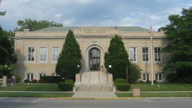
Photo: Nyttend, public domain · Wikimedia Commons
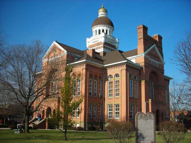
Photo: Vbdrummer0, CC BY-SA 3.0 · Wikimedia Commons
Local history sources: en.wikipedia.org · en.wikipedia.org · en.wikipedia.org · villageofpaulding.com · ia801900.us.archive.org · commons.wikimedia.org · commons.wikimedia.org
Historic places
2 places in Paulding on the National Register of Historic Places. Press a pin or a name for its whole record.
-
Paulding County Carnegie LibraryBuilding · Paulding · listed 1983
- Address
- 205 S. Main St.
- Where
- Paulding, Paulding County · ZIP 45879
- What it is
- Building
- Listed on the National Register
- 1983
- NRIS reference number
- 83002021
- Coordinates
- 41.13616, -84.57900
National Register file (NPS) ↗ Search Wikipedia ↗ Street map and directions ↗ On the Cracked Buckeye map
-
Paulding County CourthouseBuilding · Paulding · listed 1974
- Address
- Courthouse Sq.
- Where
- Paulding, Paulding County · ZIP 45879
- What it is
- Building
- Listed on the National Register
- 1974
- NRIS reference number
- 74001589
- Coordinates
- 41.13772, -84.58014
National Register file (NPS) ↗ Search Wikipedia ↗ Street map and directions ↗ On the Cracked Buckeye map
Source: National Park Service, National Register of Historic Places point file. The listing year is shown where NPS's certification date agrees with the listing's reference number. Listing recognizes significance; it does not restrict a private owner.
Water
Paulding Reservoir, fed by Flat Rock Creek The water here
- Paulding Village100% of residentsPaulding Reservoir, fed by Flat Rock Creek
Hospitals, fire stations and more
Inside Paulding's boundary: 1 hospital, 1 fire or EMS station, 1 high-hazard dam, 3 public schools, 1 library, 2 police stations, 4 Toxics Release Inventory facilities and 8 spill cases. Press a pin or a name for its whole record and its source.
Hospitals (1)
-
Paulding County HospitalCritical access hospital · Paulding
- What it is
- Critical access hospital
- Address
- 1035 West Wayne St, Paulding, OH 45879
- County
- Paulding County
- Beds
- 25
- Helipad
- Yes
- Ownership
- Government - local
- Medicare overall rating
- not rated
- Emergency department (Medicare)
- Yes
- Phone
- (419) 399-4080
- Medicare ID
- 361300
Medicare Care Compare ↗ Hospital's website ↗ Where HIFLD got this record ↗ HIFLD hospitals (source) ↗ Street map and directions ↗
Source: HIFLD hospitals inventory via FEMA (closed hospitals it still lists left out, hospitals opened since added), with Medicare Care Compare ratings matched by name and address.
Fire and EMS stations (1)
-
Paulding Fire DepartmentPaulding
- Address
- 311 West Wall Street, Paulding, OH 45879
- Coordinates
- 41.14185, -84.58365
USGS National Map structures (source) ↗ Street map and directions ↗
Source: USGS National Map structures (most Ohio records last updated 2019 to 2022), checked against the Columbus and Cleveland station lists. The department that answers a call is set by jurisdiction and mutual aid, not by distance.
High-hazard dams (1)
-
Paulding Upground ReservoirOffstream · condition: fair
- Hazard class
- High: a failure would probably cost a life
- Condition
- Fair (assessed 08/24/2023)
- River or stream
- Offstream
- Purpose
- Water Supply
- Type
- Earth
- Height
- 24 ft
- Storage
- 1,408 acre-feet
- Completed
- 1966
- Owner type
- Local Government
- County
- Paulding County
- Nearest town (NID)
- Latty
- Last inspection
- 05/11/2022
- Emergency action plan
- No
- NID ID
- OH00476
National Inventory of Dams record ↗ National Inventory of Dams (source) ↗ Street map and directions ↗
Source: U.S. Army Corps of Engineers National Inventory of Dams, August 2026. "High hazard" rates what a failure would cost downstream, not how likely one is; the condition is the state's assessment.
Public schools (3)
-
Paulding Elementary School3 of 5 stars · Paulding
- Address
- 405 N Water St, Paulding, OH 45879
- School district
- Paulding Ex Vill School District
- Kind (NCES)
- Regular School
- Students, 2023-24
- 435
- Teachers (full-time equivalent)
- 28
- Report card, 2025-26
- 3 of 5 stars
- Performance index
- 77.1%
- Ohio building IRN
- 064071
- NCES school ID
- 390455702285
NCES school record ↗ Ohio School Report Card ↗ Street map and directions ↗
-
Paulding High School3.5 of 5 stars · Paulding
- Address
- 405 N Water St, Paulding, OH 45879
- School district
- Paulding Ex Vill School District
- Kind (NCES)
- Regular School
- Students, 2023-24
- 343
- Teachers (full-time equivalent)
- 19.35
- Report card, 2025-26
- 3.5 of 5 stars
- Performance index
- 76.3%
- Four-year graduation rate
- 99%
- Ohio building IRN
- 029454
- NCES school ID
- 390455702284
NCES school record ↗ Ohio School Report Card ↗ Street map and directions ↗
-
Paulding Middle School3.5 of 5 stars · Paulding
- Address
- 405 N Water St, Paulding, OH 45879
- School district
- Paulding Ex Vill School District
- Kind (NCES)
- Regular School
- Students, 2023-24
- 266
- Teachers (full-time equivalent)
- 18.75
- Report card, 2025-26
- 3.5 of 5 stars
- Performance index
- 74.5%
- Ohio building IRN
- 029447
- NCES school ID
- 390455702286
NCES school record ↗ Ohio School Report Card ↗ Street map and directions ↗
Source: NCES EDGE public school locations 2024-25 and Common Core of Data 2023-24 (type, students, teachers); Ohio School Report Cards 2025-26 (Department of Education and Workforce), matched by name within the district.
Public libraries (1)
-
Paulding County Carnegie LibraryCentral library · Paulding
- Address
- 205 S. Main St., Paulding, OH 45879
- What it is
- Central library
- Library system
- Paulding County Carnegie Library
- Open
- 2,704 hours a year, 52 weeks
- Building
- 9,960 sq ft
- System's visits, FY2024
- 57,252
- System's loans, FY2024
- 230,430
- People the system serves
- 18,806
- Phone
- (419) 399-2032
IMLS Public Libraries Survey (source) ↗ Street map and directions ↗
Source: IMLS Public Libraries Survey FY2024 (outlets and their systems). Any Ohio resident can get a free card at any Ohio public library.
Police stations (2)
-
Paulding County Sheriff's OfficePaulding
- Address
- 500 East Perry Street, Paulding, OH 45879
- Coordinates
- 41.13694, -84.57690
Where this record comes from ↗ USGS National Map structures (source) ↗ Street map and directions ↗
-
Paulding Police DepartmentPaulding
- Address
- 116 South Main Street, Paulding, OH 45879
- Coordinates
- 41.13672, -84.58005
USGS National Map structures (source) ↗ Street map and directions ↗
Source: USGS National Map structures, police stations, corrected and completed by hand (September 2026). The department that answers a call is set by jurisdiction, not by distance.
Facilities reporting toxic releases (4)
-
Alex Products IncToxics Release Inventory · Paulding
- Address
- 810 W Gasser Rd, Paulding, OH 45879
- County
- Paulding County
- Status
- Reports to the Toxics Release Inventory (active)
- EPA program ID
- 45879LXPRD81WGA
- EPA registry ID
- 110046371760
EPA facility record ↗ EPA Facility Registry Service (source) ↗ Street map and directions ↗
-
Atlas Alchem Plastics IncToxics Release Inventory · Paulding
- Address
- 925 W. Gasser Rd., Paulding, OH 45879
- County
- Paulding County
- Status
- Reports to the Toxics Release Inventory (active)
- EPA program ID
- 45879SPRTC925WG
- EPA registry ID
- 110000395901
EPA facility record ↗ EPA Facility Registry Service (source) ↗ Street map and directions ↗
-
Herbert E. Orr CompanyToxics Release Inventory · Paulding
- Address
- 335 W. Wall St., Paulding, OH 45879
- County
- Paulding County
- Status
- Reports to the Toxics Release Inventory (active)
- EPA program ID
- 45879HRBRT335WW
- EPA registry ID
- 110000395894
EPA facility record ↗ EPA Facility Registry Service (source) ↗ Street map and directions ↗
-
Lh Thompson Steel LlcToxics Release Inventory · Paulding
- Address
- 815 W. Gasser Rd., Paulding, OH 45879
- County
- Paulding County
- Status
- Reports to the Toxics Release Inventory (active)
- EPA program ID
- 45879THMPSRT2CO
- EPA registry ID
- 110000395910
EPA facility record ↗ EPA Facility Registry Service (source) ↗ Street map and directions ↗
Source: EPA Facility Registry Service, Toxics Release Inventory reporters. Reporting a release is required of large users of listed chemicals; it is not by itself a violation.
Spills reported since 2021 (8)
-
Fuel Diesel / Diesel Fuel (Vehicle On Or Off Road)2024-08-07 · Paulding Twp
- Reported
- 2024-08-07
- What spilled
- Fuel Diesel / Diesel Fuel (Vehicle On Or Off Road); Other / All Other / Trade Name / Mixture / Solution Etc
- Where
- Paulding Twp, Paulding County
- Ohio EPA district office
- NWDO
- Ohio EPA case number
- 2408EPA0001363
Ohio EPA spill reports (source) ↗ Street map and directions ↗
-
Manure Dairy Reached water2023-09-01 · Paulding
- Reported
- 2023-09-01
- What spilled
- Manure Dairy
- Reached a waterway
- Blue Creek
- Where
- Paulding, Paulding County
- Ohio EPA district office
- NWDO
- Ohio EPA case number
- 2309EPA0001551
Ohio EPA spill reports (source) ↗ Street map and directions ↗
-
Fish Kill2023-06-26 · Paulding
- Reported
- 2023-06-26
- What spilled
- Fish Kill
- Where
- Paulding, Paulding County
- Ohio EPA district office
- NWDO
- Ohio EPA case number
- 2306EPA0001046
Ohio EPA spill reports (source) ↗ Street map and directions ↗
-
Storm Water2023-02-23 · Paulding
- Reported
- 2023-02-23
- What spilled
- Storm Water
- Where
- Paulding, Paulding County
- Ohio EPA district office
- NWDO
- Ohio EPA case number
- 2302EPA0000278
Ohio EPA spill reports (source) ↗ Street map and directions ↗
-
Sewage Human Reached water2023-02-09 · Paulding
- Reported
- 2023-02-09
- What spilled
- Sewage Human
- Reached a waterway
- 63 - Opossum Run
- Where
- Paulding, Paulding County
- Ohio EPA district office
- NWDO
- Ohio EPA case number
- 2302EPA0000198
Ohio EPA spill reports (source) ↗ Street map and directions ↗
-
Material Unknown Reached water2021-09-13 · Paulding
- Reported
- 2021-09-13
- What spilled
- Material Unknown; Fish Kill
- Reached a waterway
- 63 - Little Flatrock Creek
- Where
- Paulding, Paulding County
- Ohio EPA district office
- NWDO
- Ohio EPA case number
- 2109EPA0001441
Ohio EPA spill reports (source) ↗ Street map and directions ↗
-
Manure Dairy Reached water2021-08-27 · Paulding
- Reported
- 2021-08-27
- What spilled
- Manure Dairy
- Reached a waterway
- 99 - Unnamed
- Where
- Paulding, Paulding County
- Ohio EPA district office
- NWDO
- Ohio EPA case number
- 2108EPA0001346
Ohio EPA spill reports (source) ↗ Street map and directions ↗
-
Fuel Diesel / Diesel Fuel (Vehicle On Or Off Road)2026-07-29 · Paulding
- Reported
- 2026-07-29
- What spilled
- Fuel Diesel / Diesel Fuel (Vehicle On Or Off Road)
- Largest amount reported
- 40 gallons
- Where
- Paulding, Paulding County
- Ohio EPA district office
- NWDO
- Ohio EPA case number
- 2607EPA0001389
Ohio EPA spill reports (source) ↗ Street map and directions ↗
Source: Ohio EPA emergency response spill reports, 2021 to September 2026, one point per case where Ohio EPA placed it. A report is what the caller or responder recorded; amounts are often blank or estimated.
Its ZIP codes
Each ZIP code that touches Paulding, with the share of its residents who live here and the same headline figures as the ZIP page.
| ZIP | Share | Water | Radon | Home value | Schools | Flood |
|---|---|---|---|---|---|---|
| 45879 Paulding | 59% | Paulding Reservoir, fed by Flat Rock Creek | 4.0 pCi/L average radon | Appraisal records without year built | Paulding Exempted Village · 3.5 stars overall | 5.5% of residents in the 1% floodplain |
Local government
Who holds office in Paulding, how its elections and ballot issues came out, and the state auditor's record.
Money issues on the ballot since 2019: 12 of 13 passed; of those asking for new or higher taxes, 5 of 6.
Ballot issues
| Date | Issue | For | Against | Result |
|---|---|---|---|---|
| 2024-11-05 | 10: 10. Proposed Tax Levy (Replacement) - Village of Paulding | 582 | 825 | Failed (41.36% for) |
| 2024-11-05 | 11: 11. Proposed (Ordinance/Resolution) Electric Aggregation (By Petition) - Village of Paulding | 583 | 777 | Failed (42.87% for) |
| 2024-11-05 | 12: 12. Proposed Tax Levy (Renewal) - Village of Paulding | 1,009 | 408 | Passed (71.21% for) |
| 2024-11-05 | 13: 13. Proposed Tax Levy (Renewal) - Village of Paulding | 1,003 | 424 | Passed (70.29% for) |
| 2024-11-05 | 14: 14. Proposed Tax Levy (Replacement) - Village of Paulding | 795 | 629 | Passed (55.83% for) |
| 2024-11-05 | 15: 15. Local Liquor Option - Village of Paulding 1: 13-1 | 367 | 208 | Passed (63.83% for) |
| 2023-11-07 | Issue 15: Proposed Tax Levy (Replacement) - Paulding Village | 513 | 388 | Passed (56.94% for) |
| 2021-11-02 | 6: 6 Proposed Tax Levy - Paulding Village, replacement, police, 2.6 mills, CPT, commencing 2021 (2.6 mills, replacement) | 289 | 122 | Passed (70.32% for) |
| 2021-11-02 | 7: 7 Proposed Tax Levy - Paulding Village, replacement, police, 2.9 mills, CPT, commencing 2021 (2.9 mills, replacement) | 292 | 117 | Passed (71.39% for) |
| 2021-11-02 | 8: 8 Proposed Tax Levy - Paulding Village, replacement, police, 2.9 mills, CPT, commencing 2021 (2.9 mills, replacement) | 284 | 123 | Passed (69.78% for) |
| 2020-11-03 | 8: 8 Proposed Tax Levy (Renewal, 0.4 mill, 5 yrs, 2020-2024, EMS) Paulding Village (0.4 mills, renewal) | 1,117 | 430 | Passed (72.2% for) |
| 2020-03-17 | Issue: Proposed Municipal Income Tax PAULDING VILLAGE | 338 | 242 | Passed (58.28% for) |
| 2019-11-05 | Issue: Paulding Vill,Fire,renewal,lmill,5 years,19-23 | 498 | 142 | Passed (77.81% for) |
| 2019-11-05 | Issue: Paulding Vill,Recreation, renewal,lmill, 5 years,19-23 | 414 | 212 | Passed (66.13% for) |
| 2019-11-05 | Issue: Paulding Village,CE renewal,2 mills,5 years,19-23 (2.0 mills, renewal) | 402 | 222 | Passed (64.42% for) |
Elections for office
| Date | Office | Candidates and votes |
|---|---|---|
| 2023-11-07 | Member of Council | Lois E. Beamer 578, 47.49%; Dan Workman 639, 52.51% |
| 2023-11-07 | Mayor | Greg A. White 750, 100.0% |
| 2021-11-02 | Member of Council | Tim Boss 273, 31.74%; David M. Burtch 272, 31.63%; Randy Daeger 254, 29.53%; Write-In: Barbara M. Rife 54, 6.28%; Write-In: Uncertifed Name 7, 0.81% |
| 2019-11-05 | Member of Council | Lois E. Beamer 400, 48.31%; Dan Workman 428, 51.69% |
| 2019-11-05 | Mayor | Jim Guelde 207, 33.01%; Greg A. White 420, 66.99% |
| 2015-11-03 | Mayor | Jim Guelde 504, 49.51%; Greg Reinhart 514, 50.49% |
| 2015-11-03 | Council | Tom Diaz 355, 18.81%; Ryan Mapes 608, 32.22%; Roger Sierer 393, 20.83%; Dan Workman 531, 28.14% |
Winners in bold. Results from the county board of elections' official canvass unless marked.
Auditor of State record
- No fiscal caution, watch or emergency on the Auditor of State's lists.
- Financial Audit, 2024, released 2026-02-17
- Financial Audit, 2022 to 2023, released 2024-08-13
The county
Paulding County: 9 ZIP codes, 21 cities, villages and townships, 17,637 people.
Nearby places
Rain and snow
How much has actually fallen on Paulding, day by day, from 1893 to now. Daily totals, not averages.
- rain, last 30 days
- 0.71 in
- 2026-09-30 to 2026-10-29
- rain so far in 2026
- 30.2 in
- 1.6 in below normal for the date
- snow so far in 2026
- 9.6 in
- a normal year brings 24.1 in
- a normal year
- 37.0 in
- average of 30 years, 1991-2020
| Month | Rain (in) | Snow (in) | Days counted |
|---|---|---|---|
| October 2026 | 0.71 | — | 29 |
| September 2026 | 3.80 | — | 30 |
| August 2026 | 4.50 | — | 31 |
| July 2026 | 2.94 | — | 31 |
| June 2026 | 2.26 | — | 30 |
| May 2026 | 3.33 | — | 31 |
| April 2026 | 7.12 | — | 30 |
| March 2026 | 3.20 | 1.0 | 31 |
| February 2026 | 0.61 | 0.6 | 28 |
| January 2026 | 1.73 | 8.0 | 31 |
| December 2025 | 1.56 | 4.8 | 31 |
| November 2025 | 1.44 | 4.5 | 30 |
| Wettest year | 2011 — 50.2 in |
|---|---|
| Driest year | 1988 — 24.7 in |
| Snowiest year | 2014 — 59.7 in |
| Wettest day on record | 14 September 1972 — 6.39 in |
| Heaviest snowfall in a day | 20 December 1973 — 10.98 in |
| Deepest snow on the ground | 6 February 1982 — 20.36 in |
85% of these days are measurements from a gauge inside Paulding; the rest are estimated from the nearest gauges around it.
47,207 days of records, 1893-01-01 to 2026-10-29. Source: NOAA NCEI GHCN-Daily, 3,240 gauges in and around Ohio. A day is "gauged" when a gauge standing inside the boundary reported it, and the value is the mean of those gauges. Otherwise it is interpolated by inverse distance from every gauge reporting within 50 miles. Nothing is carried forward, back-filled or smoothed. Against NOAA nClimDiv county monthly precipitation over 136,848 complete county-months (checked 2026-10-31): correlation 0.9515, median absolute difference 0.217 in a month. Built 2026-10-31 from the Cracked Buckeye precipitation archive. Snow is the softer number — snowfall is measured by hand with a ruler, no agency publishes a gridded county snowfall series, and blowing snow defeats every observer.
Environmental permits and filings
What Ohio EPA has on file for Paulding: permits, inspections, violations, cleanups and the state loans behind sewer and water work. Every line links to the agency's own document.
- facilities and sites on file
- 20
- those placed on the map inside Paulding
| Program | Facilities and sites |
|---|---|
| Hazardous waste | 5 |
| State sewer loans | 5 |
| Wastewater and stormwater discharge | 4 |
| Air pollution | 2 |
| Brownfield | 1 |
| Composting | 1 |
| Contaminated-site cleanup | 1 |
| Voluntary cleanup | 1 |
| Date | Facility or site | What |
|---|---|---|
| PAULDING WTP * | Wastewater and stormwater discharge permit | |
| HAVILAND - PAULDING 69 KV LINE REBUILD | Wastewater and stormwater discharge permit | |
| SPARTECH LLC | Air pollution report | |
| VILLAGE OF PAULDING | Composting inspection | |
| PAULDING COUNTY LIBRARY COMMUNITY CENTER | Wastewater and stormwater discharge permit | |
| VILLAGE OF PAULDING | Composting inspection | |
| PAULDING PUTNAM ELECTRIC COOP | Wastewater and stormwater discharge permit | |
| VILLAGE OF PAULDING | Composting inspection | |
| VILLAGE OF PAULDING | Composting inspection | |
| VILLAGE OF PAULDING | Composting report | |
| PAULDING WTP * | Wastewater and stormwater discharge inspection | |
| WINKLE BLDG, PAULDING | Brownfield assessment | |
| GRIZZLY MFG, PAULDING | Voluntary cleanup technical help | |
| VILLAGE OF PAULDING | Composting inspection | |
| GRIZZLY MFG, PAULDING | Voluntary cleanup technical help | |
| WINKLE BLDG, PAULDING | Brownfield assessment | |
| WINKLE BLDG, PAULDING | Brownfield assessment | |
| WINKLE BLDG, PAULDING | Brownfield assessment | |
| WINKLE BLDG, PAULDING | Brownfield assessment | |
| WINKLE BLDG, PAULDING | Brownfield assessment | |
| VILLAGE OF PAULDING | Composting inspection | |
| WINKLE BLDG, PAULDING | Brownfield assessment | |
| VILLAGE OF PAULDING | Composting report | |
| WINKLE BLDG, PAULDING | Brownfield assessment | |
| WINKLE BLDG, PAULDING | Brownfield assessment |
Source: Ohio EPA eDocument portal (edocpub.epa.ohio.gov), indexed 2026-10-14. Facilities are placed on the map from Ohio EPA's own map layers, EPA's Facility Registry, coordinates written in the filings, or a geocoded street address. A permit filed under a private person's name (most are household septic systems) is counted but never named, placed or linked; licenses for individual workers and open-burning notices are left out entirely.
Quick answers
What county is Paulding, Ohio in?
Paulding is a village in Paulding County, Ohio, with 3,493 residents.
When was Paulding, Ohio founded?
Paulding was laid out 1848. Founders on record: land speculators anticipating the county seat's relocation. Source
How did Paulding, Ohio get its name?
Named for Paulding County itself, which in turn was named for John Paulding, one of the three New York militiamen who captured British Major John Andre in 1780. Source
What ZIP code is Paulding, Ohio?
Most of Paulding is in ZIP code 45879.
Where does Paulding, Ohio get its water?
The main water source for Paulding (Paulding Village): Paulding Reservoir, fed by Flat Rock Creek.
Cite this page
Cite this page as:
Cracked Buckeye, "Paulding, Paulding County", https://crackedbuckeye.com/place/paulding/, built 2026-10-31, accessed [date].
How to cite · Report a correction · Built 2026-10-31
