Newburgh Heights
Village · Cuyahoga County · 1,862 residents · 2% municipal income tax
Local events in Newburgh Heights
Nothing is posted for Newburgh Heights itself yet; here is what is on within 10 miles. All local events in Newburgh Heights
Know a calendar we should watch? Send the link
Checked October 20; the events page is refreshed daily.
How Newburgh Heights began
Newburgh Heights organized and incorporated in 1904 out of old Newburgh Township, one of eighteen townships the Connecticut Land Company laid out after its 1796 purchase of the Western Reserve; the name was probably taken from Newburgh, New York. Settled first by New Englanders and then by waves of Irish, Welsh, Polish, Czech, and German immigrants who worked the nearby steel mills and factories, the village stayed small -- only 400 residents in 1909 -- until a building boom beginning in 1917 subdivided its farmland into residential lots. Raus Park, later renamed Washington Park, opened in 1920 as the village's civic and recreational heart, hosting gymnastics exhibitions, concerts, nationality dances, carnivals, and political events; its 1912 bridge over Burke Brook, since demolished, once linked the park's Newburgh Heights and Cleveland sides.
Incorporated 1904, by Edwin S. Peck (first mayor, 1904-1908).
Where the name comes from
The name was probably taken from Newburgh, New York, carried over from the older Newburgh Township the village split from.
Before the town
No source we reviewed identifies a specific, named Native American village, mound, or treaty site within present Newburgh Heights; the land was part of Newburgh Township, one of eighteen townships the Connecticut Land Company laid out after buying the Western Reserve in 1796, on ground ceded to the United States by the 1795 Treaty of Greenville.
Nations recorded here: Lenape (Delaware), Wyandot.
Timeline
- — The Connecticut Land Company buys the Western Reserve and lays out Newburgh Township as one of eighteen original townships.
- — Newburgh Heights organizes and incorporates as a village, with Edwin S. Peck as its first mayor.
- — Edwin S. Peck's term as first mayor ends.
- — Population is only 400.
- — A bridge over Burke Brook is built connecting the Newburgh Heights and Cleveland sides of what becomes Washington Park.
- — A building boom begins, subdividing the village's remaining farmland into residential lots.
- — Raus Park, later renamed Washington Park, opens, becoming a hub for gymnastics exhibitions, concerts, nationality dances, carnivals, sports, and political events.
- — Population peaks at 4,152.
- — The geographic center of population of Cuyahoga County is calculated to fall within Newburgh Heights.
Stories
A steel-mill village's park, twice named
The wave of Irish, Welsh, Polish, Czech, and German families who settled Newburgh Heights to work the nearby steel mills and factories built a village that stayed modest for its first fifteen years -- only 400 people as late as 1909 -- until a 1917 building boom finally broke up the remaining farmland into house lots. The community's social center followed close behind: Raus Park opened in 1920, later renamed Washington Park, and quickly became the place where the village's gymnastics clubs, nationality dance societies, carnivals, and political rallies all happened. A bridge built across Burke Brook in 1912, connecting the park's Newburgh Heights and Cleveland sides, has since been demolished, but a photograph of it survives from the Cleveland Public Library's collections -- one small, specific trace of the infrastructure that held this steel-mill immigrant village together.
Photographs
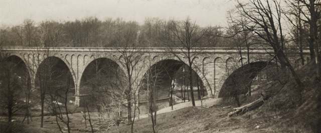
Photo: Cleveland Public Library, via Digital Public Library of America, public domain · Wikimedia Commons
Local history sources: en.wikipedia.org · case.edu · commons.wikimedia.org · en.wikipedia.org
Water
The Five Mile Crib, a small structure about 5 miles out in Lake Erie north of Cleveland's Edgewater Park The water here
- Cleveland Public Water System100% of residentsLake Erie
Hospitals, fire stations and more
Inside Newburgh Heights's boundary: 1 fire or EMS station, 1 public school, 1 police station, 3 Toxics Release Inventory facilities, 1 station or terminal and 1 spill case. Press a pin or a name for its whole record and its source.
Fire and EMS stations (1)
-
Newburgh Heights Fire DepartmentNewburgh Heights
- Address
- 4105 Harvard Avenue, Newburgh Heights, OH 44105
- Coordinates
- 41.44744, -81.66299
USGS National Map structures (source) ↗ Street map and directions ↗
Source: USGS National Map structures (most Ohio records last updated 2019 to 2022), checked against the Columbus and Cleveland station lists. The department that answers a call is set by jurisdiction and mutual aid, not by distance.
Public schools (1)
-
Washington Park Community SchoolNewburgh Heights
- Address
- 4000 Washington Park Blvd, Newburgh Heights, OH 44105
- Kind (NCES)
- Regular School
- Students, 2023-24
- 160
- NCES school ID
- 390010704153
Source: NCES EDGE public school locations 2024-25 and Common Core of Data 2023-24 (type, students, teachers); Ohio School Report Cards 2025-26 (Department of Education and Workforce), matched by name within the district.
Police stations (1)
-
Newburgh Heights Police DepartmentNewburgh Heights
- Address
- 3801 Harvard Avenue, Newburgh Heights, OH 44105
- Coordinates
- 41.44753, -81.66424
USGS National Map structures (source) ↗ Street map and directions ↗
Source: USGS National Map structures, police stations, corrected and completed by hand (September 2026). The department that answers a call is set by jurisdiction, not by distance.
Facilities reporting toxic releases (3)
-
Blue Coral/Slick 50Toxics Release Inventory · Cleveland
- Address
- 5300 Harvard Ave., Cleveland, OH 44105
- County
- Cuyahoga County
- Status
- Reports to the Toxics Release Inventory (closed)
- EPA program ID
- 44105BLCRL5300H
- EPA registry ID
- 110000386644
EPA facility record ↗ EPA Facility Registry Service (source) ↗ Street map and directions ↗
-
Mcgean-Rohco Inc 130130Toxics Release Inventory · Cleveland
- Address
- 2910 Harvard Ave, Cleveland, OH 44105
- County
- Cuyahoga County
- Status
- Reports to the Toxics Release Inventory
- EPA program ID
- 4410WMCGNC291HA
- EPA registry ID
- 110067924624
EPA facility record ↗ EPA Facility Registry Service (source) ↗ Street map and directions ↗
-
Mcgean-Rohco, Inc.Toxics Release Inventory · Cleveland
- Address
- 2910 Harvard Avenue, Cleveland, OH 44105
- County
- Cuyahoga County
- Status
- Reports to the Toxics Release Inventory (open)
- EPA program ID
- 44109MCGNR2910H
- EPA registry ID
- 110000386831
EPA facility record ↗ EPA Facility Registry Service (source) ↗ Street map and directions ↗
Source: EPA Facility Registry Service, Toxics Release Inventory reporters. Reporting a release is required of large users of listed chemicals; it is not by itself a violation.
Stations and terminals (1)
-
Harvard & E.49Rail transit stop · Greater Cleveland RTA
- What it is
- Rail transit stop
- Operator
- Greater Cleveland RTA
- Coordinates
- 41.44701, -81.65760
BTS National Transit Map (source) ↗ Street map and directions ↗
Source: BTS Intermodal Passenger Connectivity Database and National Transit Map (2025). Bus stops are counted on the card and drawn on the full map.
Spills reported since 2021 (1)
-
Oil Motor / Lube Oil / Vehicle2024-07-01 · Newburgh Heights
- Reported
- 2024-07-01
- What spilled
- Oil Motor / Lube Oil / Vehicle; Oil Hydraulic Fluid(S); Fuel Diesel / Diesel Fuel (Vehicle On Or Off Road)
- Largest amount reported
- 25 gallons
- Where
- Newburgh Heights, Cuyahoga County
- Ohio EPA district office
- NEDO
- Ohio EPA case number
- 2407EPA0001099
Ohio EPA spill reports (source) ↗ Street map and directions ↗
Source: Ohio EPA emergency response spill reports, 2021 to September 2026, one point per case where Ohio EPA placed it. A report is what the caller or responder recorded; amounts are often blank or estimated.
Its ZIP codes
Each ZIP code that touches Newburgh Heights, with the share of its residents who live here and the same headline figures as the ZIP page.
| ZIP | Share | Water | Radon | Home value | Schools | Flood |
|---|---|---|---|---|---|---|
| 44105 Cleveland | 5% | The Five Mile Crib, a small structure about 5 miles out in Lake Erie north of Cleveland's Edgewater Park | 2.8 pCi/L average radon | Median year built 1920 | Cleveland Municipal · 2.5 stars overall | 0.0% of residents in the 1% floodplain |
The county
Cuyahoga County: 52 ZIP codes, 59 cities, villages and townships, 1,270,867 people.
Nearby places
Rain and snow
How much has actually fallen on Newburgh Heights, day by day, from 1871 to now. Daily totals, not averages.
- rain, last 30 days
- 1.96 in
- 2026-09-29 to 2026-10-28
- rain so far in 2026
- 32.9 in
- about normal for the date
- snow so far in 2026
- 41.7 in
- a normal year brings 66.8 in
- a normal year
- 39.1 in
- average of 30 years, 1991-2020
| Month | Rain (in) | Snow (in) | Days counted |
|---|---|---|---|
| October 2026 | 1.95 | — | 28 |
| September 2026 | 2.57 | — | 30 |
| August 2026 | 6.55 | — | 31 |
| July 2026 | 2.61 | — | 31 |
| June 2026 | 2.89 | — | 30 |
| May 2026 | 3.95 | — | 31 |
| April 2026 | 5.86 | 0.0 | 30 |
| March 2026 | 3.78 | 2.0 | 31 |
| February 2026 | 0.58 | 7.3 | 28 |
| January 2026 | 2.11 | 32.4 | 31 |
| December 2025 | 2.60 | 15.5 | 31 |
| November 2025 | 2.29 | 8.8 | 30 |
| Wettest year | 2011 — 58.0 in |
|---|---|
| Driest year | 1963 — 18.7 in |
| Snowiest year | 2005 — 108.5 in |
| Wettest day on record | 7 September 1996 — 4.59 in |
| Heaviest snowfall in a day | 10 November 1913 — 16.52 in |
| Deepest snow on the ground | 24 February 1993 — 20.98 in |
Estimated, not measured. No rain gauge has ever stood inside Newburgh Heights, so every figure here is worked out from the gauges around it - the nearest ones weighted most. Treat them as close estimates rather than readings.
56,914 days of records, 1871-01-01 to 2026-10-28. Source: NOAA NCEI GHCN-Daily, 3,240 gauges in and around Ohio. A day is "gauged" when a gauge standing inside the boundary reported it, and the value is the mean of those gauges. Otherwise it is interpolated by inverse distance from every gauge reporting within 50 miles. Nothing is carried forward, back-filled or smoothed. Against NOAA nClimDiv county monthly precipitation over 136,848 complete county-months (checked 2026-10-31): correlation 0.9515, median absolute difference 0.217 in a month. Built 2026-10-31 from the Cracked Buckeye precipitation archive. Snow is the softer number — snowfall is measured by hand with a ruler, no agency publishes a gridded county snowfall series, and blowing snow defeats every observer.
Environmental permits and filings
What Ohio EPA has on file for Newburgh Heights: permits, inspections, violations, cleanups and the state loans behind sewer and water work. Every line links to the agency's own document.
- facilities and sites on file
- 25
- those placed on the map inside Newburgh Heights
| Program | Facilities and sites |
|---|---|
| Hazardous waste | 5 |
| Sewer and water-line construction | 4 |
| Wastewater and stormwater discharge | 4 |
| Air pollution | 3 |
| Site assessment | 3 |
| Contaminated-site cleanup | 2 |
| Chemical accident plans | 1 |
| Landfills | 1 |
| Municipal Solid Waste Transfer Facilities | 1 |
| State sewer loans | 1 |
| Date | Facility or site | What |
|---|---|---|
| CLEVELAND DIV OF WATER HARVARD DIST & MAINT | Air pollution report | |
| BERT AVENUE LANDFILL | Landfills report | |
| MCGEAN-ROHCO INC * | Hazardous waste director's orders | |
| BERT AVENUE LANDFILL | Landfills inspection | |
| BERT AVENUE LANDFILL | Landfills report | |
| RUMPKE WASTE INC HARVARD ROAD TRANSFER FACILITY | Municipal Solid Waste Transfer Facilities inspection | |
| RUMPKE WASTE INC HARVARD ROAD TRANSFER FACILITY | Municipal Solid Waste Transfer Facilities inspection | |
| BERT AVENUE LANDFILL | Landfills inspection | |
| EAST 42ND STREET AND BETA AVE | Wastewater and stormwater discharge permit | |
| CUY IR 077 1141 MAJOR REHAB PID 105743 | Wastewater and stormwater discharge permit | |
| BERT AVENUE LANDFILL | Landfills inspection | |
| BERT AVENUE LANDFILL | Landfills inspection | |
| MCGEAN-ROHCO INC * | Hazardous waste notice of violation | |
| THE WOODLANDS OF SNOWVILLE PHASE 3 | Sewer and water-line construction permit | |
| CLEVELAND DIV OF WATER HARVARD DIST & MAINT | Air pollution report | |
| BERT AVENUE LANDFILL | Landfills report | |
| BERT AVENUE LANDFILL | Landfills inspection | |
| KOCINSKI CENTER WAREHOUSE | Wastewater and stormwater discharge permit | |
| RUMPKE WASTE INC HARVARD ROAD TRANSFER FACILITY | Municipal Solid Waste Transfer Facilities report | |
| MEIJER #341 MDH | Sewer and water-line construction permit | |
| THE WOODLANDS OF SNOWVILLE PHASE 3 | Sewer and water-line construction permit | |
| BERT AVENUE LANDFILL | Landfills report | |
| BERT AVENUE LANDFILL | Landfills inspection | |
| NEW HILTON DRIVEWAY | Sewer and water-line construction permit | |
| MEIJER #341 MDH | Sewer and water-line construction permit |
Source: Ohio EPA eDocument portal (edocpub.epa.ohio.gov), indexed 2026-10-14. Facilities are placed on the map from Ohio EPA's own map layers, EPA's Facility Registry, coordinates written in the filings, or a geocoded street address. A permit filed under a private person's name (most are household septic systems) is counted but never named, placed or linked; licenses for individual workers and open-burning notices are left out entirely.
Quick answers
What county is Newburgh Heights, Ohio in?
Newburgh Heights is a village in Cuyahoga County, Ohio, with 1,862 residents.
When was Newburgh Heights, Ohio founded?
Newburgh Heights was incorporated 1904. Founders on record: Edwin S. Peck (first mayor, 1904-1908). Source
How did Newburgh Heights, Ohio get its name?
The name was probably taken from Newburgh, New York, carried over from the older Newburgh Township the village split from. Source
What ZIP code is Newburgh Heights, Ohio?
Most of Newburgh Heights is in ZIP code 44105.
Where does Newburgh Heights, Ohio get its water?
The main water source for Newburgh Heights (Cleveland Public Water System): The Five Mile Crib, a small structure about 5 miles out in Lake Erie north of Cleveland's Edgewater Park.
Cite this page
Cite this page as:
Cracked Buckeye, "Newburgh Heights, Cuyahoga County", https://crackedbuckeye.com/place/newburgh-heights/, built 2026-10-31, accessed [date].
How to cite · Report a correction · Built 2026-10-31
