Local events in Mount Victory
Mount Victory itself has 1 event posted in the next 90 days; the others here are within 10 miles. All local events in Mount Victory
Checked October 20; the events page is refreshed daily.
Deep dives about Mount Victory
Long reads built from maps, newspapers and public records. All deep dives
How Mount Victory began
Mount Victory was platted in 1851 by Ezra Dille on land belonging to his father, Cyrus Dille, one of the township's earliest settlers. According to local tradition its exuberant name came from a friend's exclamation of 'Victory!' when Ezra managed to secure the land ahead of a rival buyer who wanted it kept as pasture. The village became a station on the Bellefontaine and Indiana Railroad, a stop on the Underground Railroad through the Williams family, and today anchors the Mount Victory Historic District, listed on the National Register of Historic Places in 2001.
Settled 1829, platted 1851, by platted by Ezra Dille.
Where the name comes from
Ezra Dille's friend Thomas McCall reportedly shouted 'Victory, Victory -- We shall name the town Mount Victory!' on learning Ezra had beaten a competing buyer, Samuel McCullough, to the land purchase that let the village be founded rather than turned into pasture.
Before the town
No Native American village or encounter specific to the village site of Mount Victory is recorded in the sources searched. The village sits about two miles from the Ridgeway Site, a major Glacial Kame culture burial ground on the Hale Township line between Mount Victory and Ridgeway (see the Hale Township file for detail); no source places that site within the platted village itself.
Timeline
- — James Andrews arrives near Grassy Point and becomes the area's first landowning permanent settler.
- — Cyrus Dille, father of village founder Ezra Dille, arrives and settles in the area.
- — The first Methodist sermon in the area is preached at Lewis Andrews' home.
- — The first schoolhouse, 'The Rough and Ready,' opens with teacher Enos Baldwin.
- — Obadiah and Sarah Williams buy land a mile and a half south of the future village and begin sheltering escaped freedom seekers as part of the Underground Railroad, calling them 'guests' to mislead slave hunters and federal agents without lying outright.
- — Ezra Dille plats Mount Victory on his father's land.
- — A four-room brick schoolhouse is built in Mount Victory for $5,200.
- — The Methodist Episcopal congregation dedicates its brick church on North Main Street.
- — The Church of Christ dedicates its main auditorium.
- — The Mount Victory Historic District, centered on Main and Taylor Streets, is listed on the National Register of Historic Places.
- — Mount Victory and Ridgeway schools consolidate to form Ridgemont Local Schools, blending both towns' colors and choosing the Golden Gophers as mascot.
Stories
Breakfast for the men hunting her guests
Obadiah and Sarah Williams settled a mile and a half south of what became Mount Victory in 1848 and turned their farm into a stop on the Underground Railroad. They called the freedom seekers passing through their home 'guests,' a word chosen so they could answer questions from slave catchers and federal agents truthfully without giving anyone away. Local history records that Sarah once cooked breakfast for a group of federal agents searching the area while, at the same time, arranging for the people she was sheltering to be moved safely out of reach -- serving the hunters a meal in one room while the hunted slipped out the back.
A name born of spite and speed
In 1849 Ezra Dille went to a land auction hoping to buy ground for a new town. A rival bidder, Samuel McCullough, intended to outbid him and keep the land as pasture rather than let a village rise on it. When Ezra came away the winner, his friend Thomas McCall was overjoyed, reportedly shouting 'Victory, Victory -- We shall name the town Mount Victory!' The name stuck, and the platted village of 1851 has carried it ever since.
Photographs
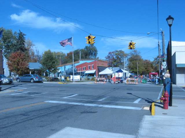
Photo: Nyttend, public domain · Wikimedia Commons
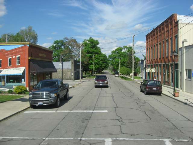
Photo: Nyttend, public domain · Wikimedia Commons
Local history sources: mountvictory.com · ohiogenealogyexpress.com · en.wikipedia.org · en.wikipedia.org · en.wikipedia.org · commons.wikimedia.org · commons.wikimedia.org
Water
Mostly private wells The water here
- Mt Victory Village100% of residentsGroundwater wells (2 wells)
Hospitals, fire stations and more
Inside Mount Victory's boundary: 1 fire or EMS station, 2 public schools, 1 library, 1 museum and 3 spill cases. Press a pin or a name for its whole record and its source.
Fire and EMS stations (1)
-
Southeast Hardin - Northwest Union Joint Fire DistrictMount Victory
- Address
- 212 South Wheeler Street, Mount Victory, OH 43340
- Coordinates
- 40.53458, -83.51566
USGS National Map structures (source) ↗ Street map and directions ↗
Source: USGS National Map structures (most Ohio records last updated 2019 to 2022), checked against the Columbus and Cleveland station lists. The department that answers a call is set by jurisdiction and mutual aid, not by distance.
Public schools (2)
-
Ridgemont Elementary School3.5 of 5 stars · Mount Victory
- Address
- 560 Taylor St W, Mount Victory, OH 43340
- School district
- Ridgemont Local School District
- Kind (NCES)
- Regular School
- Students, 2023-24
- 216
- Teachers (full-time equivalent)
- 16.65
- Report card, 2025-26
- 3.5 of 5 stars
- Performance index
- 69%
- Ohio building IRN
- 031674
- NCES school ID
- 390475002905
NCES school record ↗ Ohio School Report Card ↗ Street map and directions ↗
-
Ridgemont High School3.5 of 5 stars · Mount Victory
- Address
- 560 Taylor St W, Mount Victory, OH 43340
- School district
- Ridgemont Local School District
- Kind (NCES)
- Regular School
- Students, 2023-24
- 247
- Teachers (full-time equivalent)
- 15.1
- Report card, 2025-26
- 3.5 of 5 stars
- Performance index
- 71.2%
- Four-year graduation rate
- 100%
- Ohio building IRN
- 031716
- NCES school ID
- 390475002906
NCES school record ↗ Ohio School Report Card ↗ Street map and directions ↗
Source: NCES EDGE public school locations 2024-25 and Common Core of Data 2023-24 (type, students, teachers); Ohio School Report Cards 2025-26 (Department of Education and Workforce), matched by name within the district.
Public libraries (1)
-
Ridgemont Public LibraryCentral library · Mt. Victory
- Address
- 124 E. Taylor St., Mt. Victory, OH 43340
- What it is
- Central library
- Library system
- Ridgemont Public Library
- Open
- 1,768 hours a year, 52 weeks
- Building
- 3,840 sq ft
- System's visits, FY2024
- 8,476
- System's loans, FY2024
- 21,424
- People the system serves
- 3,469
- Phone
- (937) 354-4445
IMLS Public Libraries Survey (source) ↗ Street map and directions ↗
Source: IMLS Public Libraries Survey FY2024 (outlets and their systems). Any Ohio resident can get a free card at any Ohio public library.
Museums, historical societies, gardens and zoos (1)
-
Memorial Hall Of Mount VictoryHistorical society · Mount Victory
- What it is
- Historical society
- City
- Mount Victory
- Coordinates
- 40.53439, -83.52361
Search Wikipedia ↗ IMLS Museum Data Files (source) ↗ Street map and directions ↗
The museum list is IMLS's 2018 file; a museum may have closed or moved since.
Source: IMLS Museum Data Files, 2018.
Spills reported since 2021 (3)
-
Manure Nos (Not Specified) Reached water2025-07-22 · Mount Victory
- Reported
- 2025-07-22
- What spilled
- Manure Nos (Not Specified)
- Reached a waterway
- 99 - Unnamed
- Where
- Mount Victory, Hardin County
- Ohio EPA district office
- NWDO
- Ohio EPA case number
- 2507EPA0001221
Ohio EPA spill reports (source) ↗ Street map and directions ↗
-
Atrazine (C8H14Cln5)2025-05-02 · Mount Victory
- Reported
- 2025-05-02
- What spilled
- Atrazine (C8H14Cln5)
- Largest amount reported
- 55 gallons
- Where
- Mount Victory, Hardin County
- Ohio EPA district office
- NWDO
- Ohio EPA case number
- 2505EPA0000683
Ohio EPA spill reports (source) ↗ Street map and directions ↗
-
Fuel Diesel / Diesel Fuel (Vehicle On Or Off Road)2024-06-19 · Mount Victory
- Reported
- 2024-06-19
- What spilled
- Fuel Diesel / Diesel Fuel (Vehicle On Or Off Road)
- Largest amount reported
- 50 gallons
- Where
- Mount Victory, Hardin County
- Ohio EPA district office
- NWDO
- Ohio EPA case number
- 2406EPA0001037
Ohio EPA spill reports (source) ↗ Street map and directions ↗
Source: Ohio EPA emergency response spill reports, 2021 to September 2026, one point per case where Ohio EPA placed it. A report is what the caller or responder recorded; amounts are often blank or estimated.
Its ZIP codes
Each ZIP code that touches Mount Victory, with the share of its residents who live here and the same headline figures as the ZIP page.
| ZIP | Share | Water | Radon | Home value | Schools | Flood |
|---|---|---|---|---|---|---|
| 43340 Mount Victory | 34% | Mostly private wells | 6.0 pCi/L average radon | Median year built 1965 | Ridgemont Local · 3.5 stars overall | 0.0% of residents in the 1% floodplain |
Local government
Who holds office in Mount Victory, how its elections and ballot issues came out, and the state auditor's record.
Auditor of State record
- No fiscal caution, watch or emergency on the Auditor of State's lists.
- Agreed Upon Procedures, 2022 to 2023, released 2025-01-14
The county
Hardin County: 10 ZIP codes, 23 cities, villages and townships, 31,735 people.
Nearby places
Rain and snow
How much has actually fallen on Mount Victory, day by day, from 1893 to now. Daily totals, not averages.
- rain, last 30 days
- 0.95 in
- 2026-09-30 to 2026-10-29
- rain so far in 2026
- 43.0 in
- 9.3 in above normal for the date
- snow so far in 2026
- 17.3 in
- a normal year brings 25.5 in
- a normal year
- 39.6 in
- average of 30 years, 1991-2020
| Month | Rain (in) | Snow (in) | Days counted |
|---|---|---|---|
| October 2026 | 0.95 | — | 29 |
| September 2026 | 7.00 | — | 30 |
| August 2026 | 8.19 | — | 31 |
| July 2026 | 3.70 | — | 31 |
| June 2026 | 4.56 | — | 30 |
| May 2026 | 6.94 | — | 31 |
| April 2026 | 4.93 | — | 30 |
| March 2026 | 4.42 | 0.4 | 31 |
| February 2026 | 0.88 | 4.0 | 28 |
| January 2026 | 1.45 | 12.8 | 31 |
| December 2025 | 1.87 | 10.0 | 31 |
| November 2025 | 1.84 | 2.8 | 30 |
| Wettest year | 2011 — 57.4 in |
|---|---|
| Driest year | 1934 — 20.5 in |
| Snowiest year | 1895 — 69.8 in |
| Wettest day on record | 25 March 1913 — 3.78 in |
| Heaviest snowfall in a day | 23 December 2004 — 14.61 in |
| Deepest snow on the ground | 1 February 1978 — 21.41 in |
Estimated, not measured. No rain gauge has ever stood inside Mount Victory, so every figure here is worked out from the gauges around it - the nearest ones weighted most. Treat them as close estimates rather than readings.
48,878 days of records, 1893-01-01 to 2026-10-29. Source: NOAA NCEI GHCN-Daily, 3,240 gauges in and around Ohio. A day is "gauged" when a gauge standing inside the boundary reported it, and the value is the mean of those gauges. Otherwise it is interpolated by inverse distance from every gauge reporting within 50 miles. Nothing is carried forward, back-filled or smoothed. Against NOAA nClimDiv county monthly precipitation over 136,848 complete county-months (checked 2026-10-31): correlation 0.9515, median absolute difference 0.217 in a month. Built 2026-10-31 from the Cracked Buckeye precipitation archive. Snow is the softer number — snowfall is measured by hand with a ruler, no agency publishes a gridded county snowfall series, and blowing snow defeats every observer.
Environmental permits and filings
What Ohio EPA has on file for Mount Victory: permits, inspections, violations, cleanups and the state loans behind sewer and water work. Every line links to the agency's own document.
- facilities and sites on file
- 2
- those placed on the map inside Mount Victory
| Program | Facilities and sites |
|---|---|
| Public drinking water | 2 |
| Date | Facility or site | What |
|---|---|---|
| MT VICTORY VILLAGE PWS | Public drinking water notice of violation | |
| MT VICTORY VILLAGE PWS | Public drinking water report | |
| MT VICTORY VILLAGE PWS | Public drinking water inspection | |
| MT VICTORY VILLAGE PWS | Public drinking water notice of violation | |
| MT VICTORY VILLAGE PWS | Public drinking water plan | |
| MT VICTORY VILLAGE PWS | Public drinking water inspection | |
| MT VICTORY VILLAGE PWS | Public drinking water plan | |
| MT VICTORY VILLAGE PWS | Public drinking water notice of violation | |
| MT VICTORY VILLAGE PWS | Public drinking water plan | |
| MT VICTORY VILLAGE PWS | Public drinking water inspection | |
| MT VICTORY VILLAGE PWS | Public drinking water warning letter | |
| MT VICTORY VILLAGE PWS | Public drinking water notice of violation | |
| MOUNT VICTORY VILLAGE PWS | Public drinking water notice of violation | |
| MOUNT VICTORY VILLAGE PWS | Public drinking water inspection | |
| MT VICTORY VILLAGE PWS | Public drinking water inspection | |
| MOUNT VICTORY VILLAGE PWS | Public drinking water compliance letter | |
| MOUNT VICTORY VILLAGE PWS | Public drinking water report | |
| MOUNT VICTORY VILLAGE PWS | Public drinking water notice of violation | |
| MOUNT VICTORY VILLAGE PWS | Public drinking water inspection | |
| MOUNT VICTORY VILLAGE PWS | Public drinking water compliance letter | |
| MOUNT VICTORY VILLAGE PWS | Public drinking water compliance letter | |
| MT VICTORY VILLAGE PWS | Public drinking water inspection | |
| MOUNT VICTORY VILLAGE PWS | Public drinking water compliance letter | |
| MOUNT VICTORY VILLAGE PWS | Public drinking water compliance letter | |
| MOUNT VICTORY VILLAGE PWS | Public drinking water violation resolved |
Source: Ohio EPA eDocument portal (edocpub.epa.ohio.gov), indexed 2026-10-14. Facilities are placed on the map from Ohio EPA's own map layers, EPA's Facility Registry, coordinates written in the filings, or a geocoded street address. A permit filed under a private person's name (most are household septic systems) is counted but never named, placed or linked; licenses for individual workers and open-burning notices are left out entirely.
Quick answers
What county is Mount Victory, Ohio in?
Mount Victory is a village in Hardin County, Ohio, with 601 residents.
When was Mount Victory, Ohio founded?
Mount Victory was settled 1829; laid out 1851. Founders on record: platted by Ezra Dille. Source
How did Mount Victory, Ohio get its name?
Ezra Dille's friend Thomas McCall reportedly shouted 'Victory, Victory -- We shall name the town Mount Victory!' on learning Ezra had beaten a competing buyer, Samuel McCullough, to the land purchase that let the village be founded rather than turned into pasture. Source
What ZIP code is Mount Victory, Ohio?
Most of Mount Victory is in ZIP code 43340.
Where does Mount Victory, Ohio get its water?
The main water source for Mount Victory (Mt Victory Village): Mostly private wells.
Cite this page
Cite this page as:
Cracked Buckeye, "Mount Victory, Hardin County", https://crackedbuckeye.com/place/mount-victory/, built 2026-10-31, accessed [date].
How to cite · Report a correction · Built 2026-10-31
