Local events in Mount Pleasant
Nothing is posted for Mount Pleasant itself yet; here is what is on within 20 miles. All local events in Mount Pleasant
Know a calendar we should watch? Send the link
Checked October 20; the events page is refreshed daily.
Notable people from Mount Pleasant
Ohioans tied to this place, each with a sourced profile. All notable Ohioans
Videos about Mount Pleasant
Short videos we made from the old maps and records. All videos
How Mount Pleasant began
Mount Pleasant was settled in 1796 by Robert Carothers and Jesse Thomas and laid out as a village in 1804, but its lasting significance comes from the antislavery Quaker community that grew there after Pennsylvania Friend Nathan Updegraff arrived in 1802. In 1817 Quaker Charles Osborn founded The Philanthropist in the village, believed to be the first newspaper in the United States dedicated to abolishing slavery, and beginning in 1821 Benjamin Lundy published his own abolitionist paper, The Genius of Universal Emancipation, from Mount Pleasant before moving it to Baltimore; his house is a National Historic Landmark. Nathan's son David Updegraff served as an Underground Railroad conductor. Most of the village today forms the Mount Pleasant Historic District, itself a National Historic Landmark, and its population, which peaked at 755 in 1850, has declined to 394 by the 2020 census.
Settled 1796 (Robert Carothers and Jesse Thomas), platted 1804, incorporated date not found in sources reviewed, by Robert Carothers and Jesse Thomas.
Where the name comes from
Named for its scenic landscape; an early alternative name, Jesse-Bobtown, never gained lasting use.
Before the town
No source reviewed names a specific Native American village, mound or documented encounter within Mount Pleasant. The village's founders settled the land in 1796, the year after the Treaty of Greenville ended the Northwest Indian War and opened the region to settlement.
Nations recorded here: Lenape (Delaware), Shawnee, Wyandot.
Timeline
- — Robert Carothers and Jesse Thomas settle the land on which Mount Pleasant is built.
- — Pennsylvania Quaker Nathan Updegraff arrives, becoming a leading figure of the Short Creek Monthly Meeting of Friends.
- — Carothers and Thomas lay out the village.
- — The Friends Meetinghouse is built at 298 Market Street; it later becomes part of the Mount Pleasant Historic District.
- — Quaker Charles Osborn founds The Philanthropist in Mount Pleasant, believed to be the first newspaper in the United States dedicated to the abolition of slavery.
- — Benjamin Lundy begins publishing The Genius of Universal Emancipation from Mount Pleasant before relocating it to Baltimore.
- — Village population peaks at 755.
- — David Brainard Updegraff, Quaker minister and grandson of Nathan Updegraff, builds the brick Updegraff House on Union Street.
Stories
The first abolitionist newspaper in the country
In 1817, a Quaker printer named Charles Osborn set up shop in the small village of Mount Pleasant and began publishing The Philanthropist, a paper historians credit as the first in the United States devoted specifically to the abolition of slavery -- appearing more than a decade before William Lloyd Garrison's better-known Liberator. Osborn's example did not end with his own paper: beginning in 1821, fellow abolitionist Benjamin Lundy published his own paper, The Genius of Universal Emancipation, from the same small village before eventually moving it to Baltimore and, later, briefly employing a young Garrison himself as an assistant editor. Nathan Updegraff's son David carried the village's antislavery commitment from print into direct action, serving as an Underground Railroad conductor who helped freedom seekers move safely through the area. That density of abolitionist activity in one small Quaker village is why most of Mount Pleasant survives today as a National Historic Landmark district, its brick and stone buildings preserved as much for what was written and organized inside them as for their architecture.
Photographs
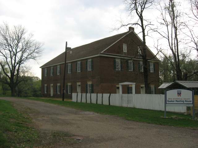
Photo: Nyttend, Wikimedia Commons, public domain · Wikimedia Commons
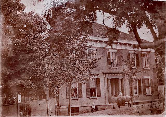
Photo: Wikimedia Commons contributor, CC BY-SA 4.0 · Wikimedia Commons
Local history sources: en.wikipedia.org · ohiogenealogyexpress.com · commons.wikimedia.org · commons.wikimedia.org
Historic places
2 places in Mount Pleasant on the National Register of Historic Places, 1 of them National Historic Landmark. Press a pin or a name for its whole record.
-
Lundy, Benjamin, House LandmarkBuilding · Mt. Pleasant · listed 1974
- Address
- Union and 3rd Sts.
- Where
- Mt. Pleasant, Jefferson County · ZIP 43939
- What it is
- Building
- Listed on the National Register
- 1974
- National Historic Landmark
- Yes
- NRIS reference number
- 74001537
- Coordinates
- 40.17477, -80.80355
National Register file (NPS) ↗ Search Wikipedia ↗ Street map and directions ↗ On the Cracked Buckeye map
-
Friends MeetinghouseBuilding · Mount Pleasant · listed 1970
- Address
- Near OH 150
- Where
- Mount Pleasant, Jefferson County · ZIP 43939
- What it is
- Building
- Listed on the National Register
- 1970
- NRIS reference number
- 70000504
- Coordinates
- 40.17355, -80.80250
National Register file (NPS) ↗ Search Wikipedia ↗ Street map and directions ↗ On the Cracked Buckeye map
Source: National Park Service, National Register of Historic Places point file. The listing year is shown where NPS's certification date agrees with the listing's reference number. Listing recognizes significance; it does not restrict a private owner.
Water
Groundwater wells (1 wells) The water here
- Mount Pleasant100% of residentsGroundwater wells (1 wells)
Hospitals, fire stations and more
Inside Mount Pleasant's boundary: 1 fire or EMS station and 1 police station. Press a pin or a name for its whole record and its source.
Fire and EMS stations (1)
-
Mount Pleasant Volunteer Fire DepartmentDillonvale
- Address
- 198 Oak Drive, Dillonvale, OH 43917
- Coordinates
- 40.17849, -80.80240
USGS National Map structures (source) ↗ Street map and directions ↗
Source: USGS National Map structures (most Ohio records last updated 2019 to 2022), checked against the Columbus and Cleveland station lists. The department that answers a call is set by jurisdiction and mutual aid, not by distance.
Police stations (1)
-
Mount Pleasant Police DepartmentMount Pleasant
- Address
- 154 Concord Street, Mount Pleasant, OH 43939
- Coordinates
- 40.17470, -80.79946
USGS National Map structures (source) ↗ Street map and directions ↗
Source: USGS National Map structures, police stations, corrected and completed by hand (September 2026). The department that answers a call is set by jurisdiction, not by distance.
Its ZIP codes
Each ZIP code that touches Mount Pleasant, with the share of its residents who live here and the same headline figures as the ZIP page.
| ZIP | Share | Water | Radon | Home value | Schools | Flood |
|---|---|---|---|---|---|---|
| 43939 Mount Pleasant | 88% | Groundwater wells (1 wells) | 3.8 pCi/L average radon | Median year built 1954 | Buckeye Local · 3 stars overall | 0.0% of residents in the 1% floodplain |
The county
Jefferson County: 21 ZIP codes, 33 cities, villages and townships, 67,859 people.
Nearby places
Rain and snow
How much has actually fallen on Mount Pleasant, day by day, from 1878 to now. Daily totals, not averages.
- rain, last 30 days
- 2.12 in
- 2026-09-30 to 2026-10-29
- rain so far in 2026
- 44.0 in
- 8.8 in above normal for the date
- snow so far in 2026
- 23.2 in
- a normal year brings 20.9 in
- a normal year
- 41.4 in
- average of 30 years, 1991-2020
| Month | Rain (in) | Snow (in) | Days counted |
|---|---|---|---|
| October 2026 | 2.12 | — | 29 |
| September 2026 | 4.96 | — | 30 |
| August 2026 | 9.82 | — | 31 |
| July 2026 | 2.79 | — | 31 |
| June 2026 | 4.85 | — | 30 |
| May 2026 | 5.83 | — | 31 |
| April 2026 | 3.73 | — | 30 |
| March 2026 | 6.96 | 4.0 | 31 |
| February 2026 | 0.98 | 3.9 | 28 |
| January 2026 | 1.92 | 15.3 | 31 |
| December 2025 | 2.49 | 11.7 | 31 |
| November 2025 | 2.67 | 0.0 | 30 |
| Wettest year | 2018 — 63.8 in |
|---|---|
| Driest year | 1930 — 24.6 in |
| Snowiest year | 1910 — 63.7 in |
| Wettest day on record | 18 September 2004 — 4.77 in |
| Heaviest snowfall in a day | 25 November 1950 — 16.12 in |
| Deepest snow on the ground | 27 November 1950 — 22.84 in |
Estimated, not measured. No rain gauge has ever stood inside Mount Pleasant, so every figure here is worked out from the gauges around it - the nearest ones weighted most. Treat them as close estimates rather than readings.
51,214 days of records, 1878-02-01 to 2026-10-29. Source: NOAA NCEI GHCN-Daily, 3,240 gauges in and around Ohio. A day is "gauged" when a gauge standing inside the boundary reported it, and the value is the mean of those gauges. Otherwise it is interpolated by inverse distance from every gauge reporting within 50 miles. Nothing is carried forward, back-filled or smoothed. Against NOAA nClimDiv county monthly precipitation over 136,848 complete county-months (checked 2026-10-31): correlation 0.9515, median absolute difference 0.217 in a month. Built 2026-10-31 from the Cracked Buckeye precipitation archive. Snow is the softer number — snowfall is measured by hand with a ruler, no agency publishes a gridded county snowfall series, and blowing snow defeats every observer.
Environmental permits and filings
What Ohio EPA has on file for Mount Pleasant: permits, inspections, violations, cleanups and the state loans behind sewer and water work. Every line links to the agency's own document.
- facilities and sites on file
- 1
- those placed on the map inside Mount Pleasant
| Program | Facilities and sites |
|---|---|
| State water loans | 1 |
| Date | Facility or site | What |
|---|---|---|
| MOUNT PLEASANT PWS | State water loans | |
| MOUNT PLEASANT PWS | State water loans | |
| MOUNT PLEASANT PWS | State water loans | |
| MOUNT PLEASANT PWS | State water loans | |
| MOUNT PLEASANT PWS | State water loans |
Source: Ohio EPA eDocument portal (edocpub.epa.ohio.gov), indexed 2026-10-14. Facilities are placed on the map from Ohio EPA's own map layers, EPA's Facility Registry, coordinates written in the filings, or a geocoded street address. A permit filed under a private person's name (most are household septic systems) is counted but never named, placed or linked; licenses for individual workers and open-burning notices are left out entirely.
Quick answers
What county is Mount Pleasant, Ohio in?
Mount Pleasant is a village in Jefferson County, Ohio, with 387 residents.
When was Mount Pleasant, Ohio founded?
Mount Pleasant was settled 1796 (Robert Carothers and Jesse Thomas); laid out 1804; incorporated date not found in sources reviewed. Founders on record: Robert Carothers and Jesse Thomas. Source
How did Mount Pleasant, Ohio get its name?
Named for its scenic landscape; an early alternative name, Jesse-Bobtown, never gained lasting use. Source
What ZIP code is Mount Pleasant, Ohio?
Most of Mount Pleasant is in ZIP code 43939.
Where does Mount Pleasant, Ohio get its water?
The main water source for Mount Pleasant (Mount Pleasant): Groundwater wells (1 wells).
Cite this page
Cite this page as:
Cracked Buckeye, "Mount Pleasant, Jefferson County", https://crackedbuckeye.com/place/mount-pleasant/, built 2026-10-31, accessed [date].
How to cite · Report a correction · Built 2026-10-31
