Local events in Kirtland
68 events in the next 90 days from 5 public calendars. All local events in Kirtland
Checked October 20; the events page is refreshed daily.
Deep dives about Kirtland
Long reads built from maps, newspapers and public records. All deep dives
How Kirtland began
Kirtland takes its name from Turhand Kirtland, a Connecticut Land Company principal and Trumbull County judge remembered for dealing fairly with Native people; the Moore family settled the area first, followed around 1811 by the Crary family. The town's defining chapter came in 1831, when Joseph Smith moved his young Church of Christ here and, over the following years, members built the Kirtland Temple by hand and ran a short-lived community bank whose 1837 collapse helped drive most of the congregation to Missouri by 1838. Kirtland incorporated as a village only in 1968 and became a city after the 1970 census, and the temple its founders built remains a National Historic Landmark and active tourist site.
Settled 1811 (Crary family, following the earlier Moore family), incorporated 1968 (village, by special election); city status after the 1970 census.
Where the name comes from
Kirtland is named for Turhand Kirtland, a principal of the Connecticut Land Company and a judge in Trumbull County, remembered locally for his fair dealings with Native people as well as for his role in the Western Reserve's settlement and survey.
Before the town
No Native American village, trail or site specific to present Kirtland is documented in the sources consulted beyond the general regional record; Turhand Kirtland, the town's namesake, is specifically remembered in local tradition for fair dealing with Native people during the Western Reserve's settlement era, though no further detail on those interactions was found. Lake County's broader Native history includes the Whittlesey-culture site at Indian Point in LeRoy Township.
Timeline
- — The Crary family settles in Kirtland, following the earlier John Moore family among the area's first European-American residents.
- — Joseph Smith formally organizes the Church of Christ (Latter Day Saint movement) in New York in 1830 and relocates its headquarters to Kirtland in 1831.
- — Church members build the Kirtland Temple by hand -- quarrying Berea sandstone, milling their own lumber, and crushing glassware into the exterior stucco -- dedicating the finished building March 27, 1836 in a seven-hour service attended by about 1,000 people.
- — The church-run Kirtland Safety Society bank fails amid a national financial panic; dissenters briefly control the temple, and most of the congregation, including Joseph Smith, leaves for Missouri by early 1838.
- — A probate sale disperses the temple to settle Smith's estate; the Reorganized LDS Church (later Community of Christ) buys a quitclaim deed in 1874 and, after a lawsuit, secures clear legal title by adverse possession by 1901.
- — The Kirtland Temple is listed on the National Register of Historic Places on June 4, and becomes a National Historic Landmark in 1977.
- — Kirtland incorporates as a village following a special citizen election; it becomes a city after the 1970 census records a population above 5,000.
- — The Church of Jesus Christ of Latter-day Saints buys the Kirtland Temple and other historic sites from Community of Christ for $192.5 million on March 5; the temple remains open for free public tours.
Stories
A temple raised by hand, and the bank that emptied it
When Joseph Smith moved his young church to Kirtland in 1831, its members had almost no money and no trained builders, so they built their temple themselves: men not away on missions quarried Berea sandstone at Gildersleeve Mountain, floated walnut, cedar, cherry and white oak logs down the Chagrin River to a sawmill the congregation built for the purpose, and women under Emma Smith's direction sewed canvas curtains and crushed glassware into the exterior stucco so the finished walls would glitter in the sun. The cornerstone was laid July 23, 1833; the finished building, blending Federal, Greek Revival and Gothic Revival styles with more than 2,500 windowpanes, was dedicated March 27, 1836, in a seven-hour service attended by roughly 1,000 people, and on April 3 Smith and Oliver Cowdery reported a vision inside it that the church later canonized as scripture. The community's fortunes reversed fast: the church-run Kirtland Safety Society, an unchartered bank, collapsed in 1837 amid the same national panic that was sinking banks nationwide, and dissenters briefly seized the temple before most of the congregation left for Missouri in 1838. The building passed through a probate sale, a schoolhouse tenancy, and a long ownership fight before the Reorganized LDS Church (now Community of Christ) secured clear title by 1901; it operated as a museum for over a century before the LDS Church bought it back in 2024 for $192.5 million as part of a larger acquisition of historic sites.
Photographs
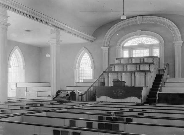
Photo: Carl F. Waite, Historic American Buildings Survey, Library of Congress, via Wikimedia Commons, Public domain · Wikimedia Commons
Local history sources: en.wikipedia.org · en.wikipedia.org · commons.wikimedia.org
Historic places
3 places in Kirtland on the National Register of Historic Places, 1 of them National Historic Landmark. Press a pin or a name for its whole record.
-
Kirtland Temple LandmarkBuilding · Kirtland · listed 1969
- Address
- 9020 Chillicothe Rd.
- Where
- Kirtland, Lake County · ZIP 44094
- What it is
- Building
- Listed on the National Register
- 1969
- National Historic Landmark
- Yes
- NRIS reference number
- 69000145
- Coordinates
- 41.62539, -81.36200
National Register file (NPS) ↗ Search Wikipedia ↗ Street map and directions ↗ On the Cracked Buckeye map
-
Old South ChurchBuilding · Kirtland · listed 1973
- Address
- 9802 Chillicothe Rd.
- Where
- Kirtland, Lake County · ZIP 44094
- What it is
- Building
- Listed on the National Register
- 1973
- NRIS reference number
- 73001485
- Coordinates
- 41.60444, -81.35024
National Register file (NPS) ↗ Search Wikipedia ↗ Street map and directions ↗ On the Cracked Buckeye map
-
Whitney, Newel K., StoreBuilding · Kirtland · listed 1984
- Address
- 8881 Chillicothe Rd.
- Where
- Kirtland, Lake County · ZIP 44094
- What it is
- Building
- Listed on the National Register
- 1984
- NRIS reference number
- 84003759
- Coordinates
- 41.62935, -81.36142
National Register file (NPS) ↗ Search Wikipedia ↗ Street map and directions ↗ On the Cracked Buckeye map
Source: National Park Service, National Register of Historic Places point file. The listing year is shown where NPS's certification date agrees with the listing's reference number. Listing recognizes significance; it does not restrict a private owner.
Water
Lake Erie, drawn through a 60-inch intake pipe extending about 3,100 feet offshore from the Aquarius plant in Willoughby The water here
- Lake County West Water Subdistrict84% of residentsLake Erie
- Aqua Ohio - Mentor16% of residentsLake Erie
Hospitals, fire stations and more
Inside Kirtland's boundary: 1 health center, 1 nursing home, 2 fire and EMS stations, 1 college, 3 public schools, 1 library, 1 museum, 1 police station, 2 public charging sites and 4 spill cases. Press a pin or a name for its whole record and its source.
Community health centers (1)
-
Signature Health Kirtland AdministrationHealth center · Willoughby
- Run by
- a federally qualified health center
- Setting
- Clinic
- City
- Willoughby
- Coordinates
- 41.63612, -81.37071
Find a Health Center (HRSA) ↗ HRSA data (source) ↗ Street map and directions ↗
Source: HRSA health center service delivery sites, active, September 2026 (school-based sites left out). Health centers see patients whether or not they have insurance, with fees on a sliding scale.
Nursing homes (1)
-
Kirtland Woods of Journey1 of 5 stars · Kirtland
- Address
- 9685 Chillicothe Rd, Kirtland, OH 44094
- Certified beds
- 177
- Residents on an average day
- 59
- Medicare overall rating
- 1 of 5 stars
- Health inspections
- 1 of 5 stars
- Staffing
- 1 of 5 stars
- Quality measures
- 3 of 5 stars
- Penalties since 2023
- 1 fine totalling $162,637, 1 payment denial (latest 2024-05-02)
- Ownership
- For profit - Limited Liability company
- Chain
- JOURNEY HEALTHCARE
- Takes
- Medicare and Medicaid
- Phone
- (440) 256-8100
- Medicare ID
- 365290
Medicare Care Compare ↗ CMS nursing home data (source) ↗ Street map and directions ↗
Source: CMS Care Compare nursing home provider and penalties files; Medicare star ratings run 1 to 5.
Fire and EMS stations (2)
-
Kirtland Fire Department Station 1Kirtland
- Address
- 8979 Kirtland Chardon Road, Kirtland, OH 44094
- Coordinates
- 41.60645, -81.32006
USGS National Map structures (source) ↗ Street map and directions ↗
-
Kirtland Fire Department Station 2Kirtland
- Address
- 10282 Chillicothe Road, Kirtland, OH 44094
- Coordinates
- 41.59155, -81.34941
USGS National Map structures (source) ↗ Street map and directions ↗
Source: USGS National Map structures (most Ohio records last updated 2019 to 2022), checked against the Columbus and Cleveland station lists. The department that answers a call is set by jurisdiction and mutual aid, not by distance.
Colleges (1)
-
Lakeland Community CollegePublic two-year college · Kirtland
- What it is
- Public two-year college
- City
- Kirtland
- Students, 2023-24 (12-month count)
- 6,705
- Tuition and fees, in state
- $4,607
- Tuition and fees, in district
- $3,872
- Tuition and fees, out of state
- $9,235
- Graduation rate
- 23% within three years (a class of 376)
- IPEDS unit ID
- 203599
College Navigator (NCES) ↗ IPEDS data (source) ↗ Street map and directions ↗
Source: NCES IPEDS 2024 directory, 2023-24 enrollment and tuition, graduation rates for the 2017 (four-year) and 2020 (two-year) entering classes.
Public schools (3)
-
Kirtland Elementary School5 of 5 stars · Kirtland
- Address
- 9140 Chillicothe Rd, Kirtland, OH 44094
- School district
- Kirtland Local School District
- Kind (NCES)
- Regular School
- Students, 2023-24
- 481
- Teachers (full-time equivalent)
- 26
- Report card, 2025-26
- 5 of 5 stars
- Performance index
- 94.2%
- Ohio building IRN
- 019208
- NCES school ID
- 390478703016
NCES school record ↗ Ohio School Report Card ↗ Street map and directions ↗
-
Kirtland High School5 of 5 stars · Kirtland
- Address
- 9150 Chillicothe Rd, Kirtland, OH 44094
- School district
- Kirtland Local School District
- Kind (NCES)
- Regular School
- Students, 2023-24
- 362
- Teachers (full-time equivalent)
- 18
- Report card, 2025-26
- 5 of 5 stars
- Performance index
- 95.5%
- Four-year graduation rate
- 100%
- Ohio building IRN
- 019216
- NCES school ID
- 390478703017
NCES school record ↗ Ohio School Report Card ↗ Street map and directions ↗
-
Kirtland Middle School4 of 5 stars · Kirtland
- Address
- 9152 Chillicothe Rd, Kirtland, OH 44094
- School district
- Kirtland Local School District
- Kind (NCES)
- Regular School
- Students, 2023-24
- 260
- Teachers (full-time equivalent)
- 12
- Report card, 2025-26
- 4 of 5 stars
- Performance index
- 92.3%
- Ohio building IRN
- 019224
- NCES school ID
- 390478703018
NCES school record ↗ Ohio School Report Card ↗ Street map and directions ↗
Source: NCES EDGE public school locations 2024-25 and Common Core of Data 2023-24 (type, students, teachers); Ohio School Report Cards 2025-26 (Department of Education and Workforce), matched by name within the district.
Public libraries (1)
-
Kirtland Public LibraryCentral library · Kirtland
- Address
- 9267 Chillicothe Rd., Kirtland, OH 44094
- What it is
- Central library
- Library system
- Kirtland Public Library
- Open
- 3,120 hours a year, 52 weeks
- Building
- 14,000 sq ft
- System's visits, FY2024
- 41,808
- System's loans, FY2024
- 151,875
- People the system serves
- 7,970
- Phone
- (440) 256-7323
IMLS Public Libraries Survey (source) ↗ Street map and directions ↗
Source: IMLS Public Libraries Survey FY2024 (outlets and their systems). Any Ohio resident can get a free card at any Ohio public library.
Museums, historical societies, gardens and zoos (1)
-
Lake Metroparks FarmparkMuseum · Kirtland
- What it is
- Museum
- City
- Kirtland
- Coordinates
- 41.58615, -81.34518
Search Wikipedia ↗ IMLS Museum Data Files (source) ↗ Street map and directions ↗
The museum list is IMLS's 2018 file; a museum may have closed or moved since.
Source: IMLS Museum Data Files, 2018.
Police stations (1)
-
Kirtland Police DepartmentKirtland
- Address
- 9301 Chillicothe Road, Kirtland, OH 44094
- Coordinates
- 41.61838, -81.35628
USGS National Map structures (source) ↗ Street map and directions ↗
Source: USGS National Map structures, police stations, corrected and completed by hand (September 2026). The department that answers a call is set by jurisdiction, not by distance.
Public EV charging (2)
-
E BUILDING STATION 22 Level 2 · Kirtland
- Address
- 770 Clocktower Drive, Kirtland, OH 44094
- Ports
- 2 Level 2
- Plugs
- J1772
- Network
- ChargePoint Network
- Hours
- 24 hours daily
- Phone
- 888-758-4389
Station Locator (NREL) ↗ Alternative Fuels Data Center (source) ↗ Street map and directions ↗
-
Frank J. Polivka Transit Center at Lakeland Community College2 Level 2 · Kirtland
- Address
- 7700 Clocktower Dr, Kirtland, OH 44094
- Ports
- 2 Level 2
- Plugs
- J1772
- Network
- FLO
- Hours
- 24 hours daily
- Phone
- 888-356-8911
Station Locator (NREL) ↗ Alternative Fuels Data Center (source) ↗ Street map and directions ↗
Source: NREL Alternative Fuels Data Center station list (May 2026), public and open stations, the posts at one address counted as one site.
Spills reported since 2021 (4)
-
Sewage Human2025-05-06 · Kirtland
- Reported
- 2025-05-06
- What spilled
- Sewage Human
- Largest amount reported
- 10 gallons
- Where
- Kirtland, Lake County
- Ohio EPA district office
- NEDO
- Ohio EPA case number
- 2505EPA0000716
Ohio EPA spill reports (source) ↗ Street map and directions ↗
-
Oil Transformer Non Pcb2025-04-29 · Kirtland
- Reported
- 2025-04-29
- What spilled
- Oil Transformer Non Pcb
- Largest amount reported
- 10 gallons
- Where
- Kirtland, Lake County
- Ohio EPA district office
- NEDO
- Ohio EPA case number
- 2504EPA0000664
Ohio EPA spill reports (source) ↗ Street map and directions ↗
-
Fuel Diesel / Diesel Fuel (Vehicle On Or Off Road)2025-04-10 · Kirtland
- Reported
- 2025-04-10
- What spilled
- Fuel Diesel / Diesel Fuel (Vehicle On Or Off Road)
- Where
- Kirtland, Lake County
- Ohio EPA district office
- NEDO
- Ohio EPA case number
- 2504EPA0000538
Ohio EPA spill reports (source) ↗ Street map and directions ↗
-
Material Unknown2023-06-26 · Kirtland
- Reported
- 2023-06-26
- What spilled
- Material Unknown
- Where
- Kirtland, Lake County
- Ohio EPA district office
- NEDO
- Ohio EPA case number
- 2306EPA0001049
Ohio EPA spill reports (source) ↗ Street map and directions ↗
Source: Ohio EPA emergency response spill reports, 2021 to September 2026, one point per case where Ohio EPA placed it. A report is what the caller or responder recorded; amounts are often blank or estimated.
Its ZIP codes
Each ZIP code that touches Kirtland, with the share of its residents who live here and the same headline figures as the ZIP page.
| ZIP | Share | Water | Radon | Home value | Schools | Flood |
|---|---|---|---|---|---|---|
| 44094 Willoughby | 18% | Lake Erie, drawn through a 60-inch intake pipe extending about 3,100 feet offshore from the Aquarius plant in Willoughby | 2.4 pCi/L average radon | Median year built 1973 | Willoughby-Eastlake City · 3.5 stars overall | 1.6% of residents in the 1% floodplain |
Local government
Who holds office in Kirtland, how its elections and ballot issues came out, and the state auditor's record.
Who holds office
| Office | Name | Party | Term ends | Contact |
|---|---|---|---|---|
| Mayor | Kevin Potter | Democratic | 2027 | 7851 Russellhurst Dr. Kirtland, OH 44094 |
| Council-at-Large | Matthew G. Schulz | Republican | 2029 | 10664 Chillicothe Rd Kirtland, OH 44094 |
| Council-at-Large | Eric C. Ziegler | Republican | 2029 | 7030 Kelsey Ct. Kirtland, OH 44094 |
| Council-at-Large | Ronald E. Fenstermaker | 2029 | 8851 Billings Rd. Kirtland, OH 44094 | |
| Ward One | Julie Symonds | Republican | 2027 | 7635 Markell Rd. Kirtland, OH 44094 |
| Ward Two | Scott Haymer | 2027 | 8110 Forestdale Dr. Kirtland, OH 44094 | |
| Ward Three | Joseph Smolic | Republican | 2027 | 7295 Ledgewood Dr. Kirtland, OH 44094 |
| Ward Four | Suzanne M. Grazia | Republican | 2027 | 10338 Loreto Ridge Rd. Kirtland, OH 44094 |
Roster as of 2026-01-23: county board of elections.
Money issues on the ballot since 2021: 1 of 1 passed.
Ballot issues
| Date | Issue | For | Against | Result |
|---|---|---|---|---|
| 2025-11-04 | 3: 3 Kirtland City Ward 1 Precinct A Local Option (Casa Rossa) | 240 | 42 | Passed (85.11% for) |
| 2024-11-05 | 2: 2 Kirtland City Charter Amendment | 2,015 | 2,294 | Failed (46.76% for) |
| 2024-11-05 | 3: 3 Kirtland City Ward 1 Precinct A Local Option (Mike's) | 813 | 173 | Passed (82.45% for) |
| 2024-11-05 | 4: 4 Kirtland City Ward 1 Precinct A Local Option (Well) | 800 | 180 | Passed (81.63% for) |
| 2023-11-07 | 3: Issue 3. Proposed Zoning Map Amendment - Kirtland City | 2,120 | 973 | Passed (68.54% for) |
| 2022-11-08 | 6: Issue 6. Charter Amendment - Kirtland City | 1,517 | 1,937 | Failed (43.92% for) |
| 2021-11-02 | 3: Issue 3. Tax Levy (Renewal) - Kirtland City | 1,338 | 606 | Passed (68.83% for) |
Elections for office
| Date | Office | Candidates and votes |
|---|---|---|
| 2025-11-04 | Member of Council at Large | Ronald E. Fenstermaker 687, 31.43%; Matthew G. Schulz 763, 34.9%; Eric C. Ziegler 736, 33.67% |
| 2023-11-07 | Mayor | Douglas E. Davidson 1,060, 31.59%; Kevin Potter 2,041, 60.82%; Kathryn Talty 255, 7.6% |
| 2021-11-02 | Member of Council at Large | Ronald E. Fenstermaker 1,123, 22.72%; Carol L. Martz 906, 18.33%; Matthew G. Schulz 1,148, 23.22%; Heather Linc Zahn 792, 16.02%; Eric C. Ziegler 974, 19.7% |
Winners in bold. Results from the county board of elections' official canvass unless marked.
Auditor of State record
- No fiscal caution, watch or emergency on the Auditor of State's lists.
- Financial Health Indicators (the Auditor of State's 17 measures; critical / cautionary / positive): 2020 2 / 1 / 14; 2021 3 / 1 / 13; 2022 4 / 2 / 11; 2023 2 / 0 / 15; 2024 2 / 3 / 12; 2025 3 / 2 / 11.
- Financial Audit, 2024, released 2026-02-05
- Financial Audit, 2023, released 2025-06-03
The county
Lake County: 8 ZIP codes, 23 cities, villages and townships, 232,447 people.
Nearby places
Rain and snow
How much has actually fallen on Kirtland, day by day, from 1871 to now. Daily totals, not averages.
- rain, last 30 days
- 1.51 in
- 2026-09-29 to 2026-10-28
- rain so far in 2026
- 33.6 in
- 5.7 in below normal for the date
- snow so far in 2026
- 45.6 in
- a normal year brings 82.3 in
- a normal year
- 47.8 in
- average of 30 years, 1991-2020
| Month | Rain (in) | Snow (in) | Days counted |
|---|---|---|---|
| October 2026 | 1.51 | — | 28 |
| September 2026 | 3.11 | — | 30 |
| August 2026 | 6.73 | — | 31 |
| July 2026 | 2.83 | — | 31 |
| June 2026 | 3.10 | — | 30 |
| May 2026 | 3.88 | 0.0 | 31 |
| April 2026 | 5.26 | 0.0 | 30 |
| March 2026 | 4.23 | 2.4 | 31 |
| February 2026 | 0.56 | 7.7 | 28 |
| January 2026 | 2.37 | 35.5 | 31 |
| December 2025 | 3.08 | 14.6 | 31 |
| November 2025 | 2.08 | 7.1 | 30 |
| Wettest year | 2011 — 74.9 in |
|---|---|
| Driest year | 1963 — 24.0 in |
| Snowiest year | 1969 — 146.4 in |
| Wettest day on record | 28 July 2006 — 6.70 in |
| Heaviest snowfall in a day | 17 January 2022 — 14.27 in |
| Deepest snow on the ground | 14 November 1996 — 33.29 in |
Mostly estimated. Only 3% of these days come from a gauge standing inside Kirtland - the rest are worked out from the nearest gauges around it, so read them as close estimates rather than readings.
56,914 days of records, 1871-01-01 to 2026-10-28. Source: NOAA NCEI GHCN-Daily, 3,240 gauges in and around Ohio. A day is "gauged" when a gauge standing inside the boundary reported it, and the value is the mean of those gauges. Otherwise it is interpolated by inverse distance from every gauge reporting within 50 miles. Nothing is carried forward, back-filled or smoothed. Against NOAA nClimDiv county monthly precipitation over 136,848 complete county-months (checked 2026-10-31): correlation 0.9515, median absolute difference 0.217 in a month. Built 2026-10-31 from the Cracked Buckeye precipitation archive. Snow is the softer number — snowfall is measured by hand with a ruler, no agency publishes a gridded county snowfall series, and blowing snow defeats every observer.
Environmental permits and filings
What Ohio EPA has on file for Kirtland: permits, inspections, violations, cleanups and the state loans behind sewer and water work. Every line links to the agency's own document.
- facilities and sites on file
- 27
- those placed on the map inside Kirtland
| Program | Facilities and sites |
|---|---|
| Hazardous waste | 5 |
| Wastewater and stormwater discharge | 5 |
| Wetland and stream fill | 5 |
| Air pollution | 2 |
| Composting | 2 |
| Landfills | 2 |
| Public drinking water | 2 |
| Site assessment | 2 |
| State sewer loans | 1 |
| Underground injection wells | 1 |
Source: Ohio EPA eDocument portal (edocpub.epa.ohio.gov), indexed 2026-10-14. Facilities are placed on the map from Ohio EPA's own map layers, EPA's Facility Registry, coordinates written in the filings, or a geocoded street address. A permit filed under a private person's name (most are household septic systems) is counted but never named, placed or linked; licenses for individual workers and open-burning notices are left out entirely.
Quick answers
What county is Kirtland, Ohio in?
Kirtland is a city in Lake County, Ohio, with 6,937 residents.
When was Kirtland, Ohio founded?
Kirtland was settled 1811 (Crary family, following the earlier Moore family); incorporated 1968 (village, by special election); city status after the 1970 census. Source
How did Kirtland, Ohio get its name?
Kirtland is named for Turhand Kirtland, a principal of the Connecticut Land Company and a judge in Trumbull County, remembered locally for his fair dealings with Native people as well as for his role in the Western Reserve's settlement and survey. Source
What ZIP code is Kirtland, Ohio?
Most of Kirtland is in ZIP code 44094.
Where does Kirtland, Ohio get its water?
The main water source for Kirtland (Lake County West Water Subdistrict): Lake Erie, drawn through a 60-inch intake pipe extending about 3,100 feet offshore from the Aquarius plant in Willoughby.
Cite this page
Cite this page as:
Cracked Buckeye, "Kirtland, Lake County", https://crackedbuckeye.com/place/kirtland/, built 2026-10-31, accessed [date].
How to cite · Report a correction · Built 2026-10-31
