Local events in Jefferson
51 events in the next 90 days from 4 public calendars. All local events in Jefferson
Checked October 20; the events page is refreshed daily.
Notable people from Jefferson
Ohioans tied to this place, each with a sourced profile. All notable Ohioans
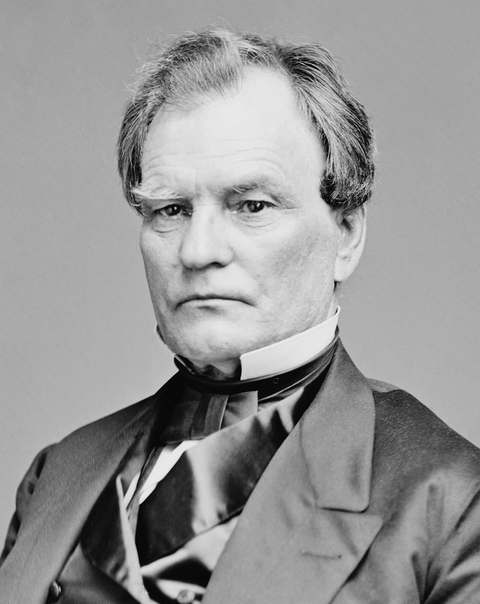
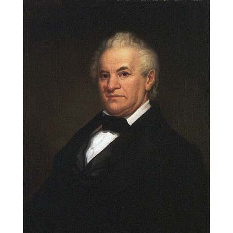
How Jefferson began
Jefferson was laid out in 1803 by Gideon Granger, U.S. Postmaster General under President Thomas Jefferson, who envisioned a grand "Philadelphia of the West" street plan for a town that, when the Samuel Wilson family arrived as its first permanent residents in 1805, was still unbroken wilderness. It became Ashtabula County's seat in 1811 and grew into one of the Western Reserve's centers of antislavery politics: Joshua Reed Giddings and Benjamin Wade practiced law together here from 1831, both going on to become nationally prominent abolitionist officeholders, and John Brown's eldest son John Brown Jr. lived in the village while helping plan his father's 1859 raid on Harpers Ferry. Several Jefferson houses served the Underground Railroad, and the village fairgrounds later trained Union recruits at Civil War-era Fort Giddings.
Settled 1805 (Samuel Wilson family, first permanent residents), platted 1803, by Gideon Granger, U.S. Postmaster General under Thomas Jefferson.
Where the name comes from
Jefferson was named for President Thomas Jefferson by its founder, Gideon Granger, who served as Jefferson's Postmaster General.
Before the town
No Native American village, trail, or site specific to Jefferson is documented in the sources consulted.
Timeline
- — Gideon Granger, U.S. Postmaster General, lays out Jefferson with a grand street plan modeled on Philadelphia.
- — The Samuel Wilson family arrives as the settlement's first permanent residents, finding only wilderness where a thriving town had been promised; Wilson dies after two weeks of labor preparing for winter, but his family stays.
- — Jefferson becomes the seat of Ashtabula County.
- — Joshua Reed Giddings and Benjamin Wade form a law partnership in Jefferson, working together until Giddings's 1838 election to Congress; both go on to become leading antislavery officeholders and founders of the Republican Party.
- — Congressman Joshua Giddings, of Jefferson, introduces resolutions on the Creole case arguing enslaved people had the right to reclaim their liberty; the House censures him for violating the gag rule and bars him from speaking in his own defense. He resigns and is reelected in a special election by 7,469 votes to 383, the widest margin in House history to that point.
- — Several Jefferson houses serve as Underground Railroad stations, and John Brown speaks in the village.
- — John Brown Jr., living in Jefferson and serving as his father's intelligence agent and liaison for the planned raid on Harpers Ferry, travels to Conneaut to retrieve secretly shipped weapons and moves them to a farm in Cherry Valley Township; after the raid, his brother Owen takes refuge with him in Jefferson.
- — Joshua Reed Giddings dies on May 27 in Montreal and is buried at Oakdale Cemetery in Jefferson.
- — The Benjamin F. Wade House at 22 Jefferson Street is designated a National Historic Landmark.
- — The Benjamin F. Wade House is demolished in the summer, and its owner converts the lot to a parking area; its National Historic Landmark status is formally withdrawn shortly after.
Stories
The censure that backfired
On March 21, 1842, Congressman Joshua Reed Giddings of Jefferson rose in the House of Representatives to introduce resolutions on the Creole affair, in which enslaved people being shipped along the American coast had seized the vessel and sailed it to freedom in the Bahamas. Giddings argued that people enslaved on a ship in international waters had every right to claim their own liberty -- a position that ran directly against the House's gag rule forbidding debate on slavery. The House voted to censure him and refused to let him speak in his own defense. Giddings did not wait to be driven out: he resigned his seat immediately and went home to Ashtabula County to ask his constituents directly whether they backed him. They answered overwhelmingly -- 7,469 votes to 383, the widest margin in any congressional election up to that time -- and sent him back to Washington within weeks, his authority strengthened rather than broken by the attempt to silence him. Giddings and his former law partner in Jefferson, Benjamin Wade, went on to become two of the most consequential antislavery politicians in the years before the Civil War, and both are counted among the founders of the Republican Party.
Photographs
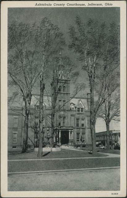
Photo: Columbus Metropolitan Library, via Digital Public Library of America, No known copyright restrictions · Wikimedia Commons
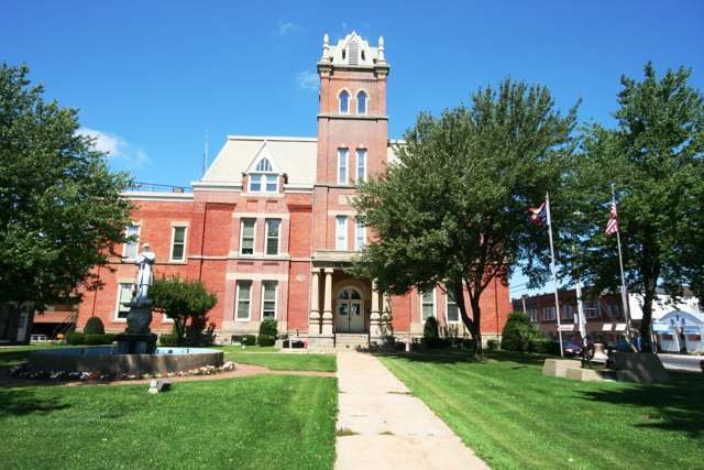
Photo: OZinOH, via Wikimedia Commons/Flickr, CC BY 2.0 · Wikimedia Commons
Local history sources: en.wikipedia.org · en.wikipedia.org · en.wikipedia.org · en.wikipedia.org · commons.wikimedia.org · commons.wikimedia.org
Historic places
4 places in Jefferson on the National Register of Historic Places, 1 of them National Historic Landmark. Press a pin or a name for its whole record.
-
Giddings, Joshua Reed, Law Office LandmarkBuilding · Jefferson · listed 1974
- Address
- 112 N. Chestnut St.
- Where
- Jefferson, Ashtabula County · ZIP 44047
- What it is
- Building
- Listed on the National Register
- 1974
- National Historic Landmark
- Yes
- NRIS reference number
- 74001396
- Coordinates
- 41.74060, -80.76897
National Register file (NPS) ↗ Search Wikipedia ↗ Street map and directions ↗ On the Cracked Buckeye map
-
Ashtabula County Courthouse GroupHistoric district · Jefferson · listed 1975
- Address
- NW corner of Jefferson and Chestnut Sts.
- Where
- Jefferson, Ashtabula County · ZIP 44047
- What it is
- Historic district
- Listed on the National Register
- 1975
- NRIS reference number
- 75001316
- Coordinates
- 41.73860, -80.76976
National Register file (NPS) ↗ Search Wikipedia ↗ Street map and directions ↗ On the Cracked Buckeye map
-
Jefferson Town HallBuilding · Jefferson · listed 1981
- Address
- 27 E. Jefferson St.
- Where
- Jefferson, Ashtabula County · ZIP 44047
- What it is
- Building
- Listed on the National Register
- 1981
- NRIS reference number
- 81000428
- Coordinates
- 41.73868, -80.76796
National Register file (NPS) ↗ Search Wikipedia ↗ Street map and directions ↗ On the Cracked Buckeye map
-
Lake Shore & Michigan Southern Railroad StationBuilding · Jefferson · listed 1982
- Address
- 147 E. Jefferson St.
- Where
- Jefferson, Ashtabula County · ZIP 44047
- What it is
- Building
- Listed on the National Register
- 1982
- NRIS reference number
- 82001357
- Coordinates
- 41.73930, -80.76182
National Register file (NPS) ↗ Search Wikipedia ↗ Street map and directions ↗ On the Cracked Buckeye map
Source: National Park Service, National Register of Historic Places point file. The listing year is shown where NPS's certification date agrees with the listing's reference number. Listing recognizes significance; it does not restrict a private owner.
Water
Mostly private wells The water here
- Aqua Ohio - Village of Jefferson98% of residentsLake Erie
- Dfc Mobile Home Park2% of residentsGroundwater wells (4 wells)
Hospitals, fire stations and more
Inside Jefferson's boundary: 1 dialysis center, 1 nursing home, 1 fire or EMS station, 4 public schools, 1 library, 2 museums, 2 police stations, 4 Toxics Release Inventory facilities and 3 spill cases. Press a pin or a name for its whole record and its source.
Dialysis centers (1)
-
Center For Dialysis Care, JeffersonDialysis · Jefferson
- Address
- 222 East Beech Street, Jefferson, OH 44047
- Dialysis stations
- 10
- Medicare star rating
- 2 of 5 stars
- Services
- in-center hemodialysis
- Ownership
- nonprofit
- Chain
- Centers for Dialysis Care
- Medicare certified since
- 1996-09-23
- Phone
- (800) 352-3647
- Medicare ID
- 362564
Medicare Care Compare ↗ CMS dialysis facility list (source) ↗ Street map and directions ↗
Source: CMS dialysis facility list, September 2026, geocoded with the Census Bureau batch geocoder (an address it could not place sits at its ZIP center).
Nursing homes (1)
-
Jefferson Healthcare Center4 of 5 stars · Jefferson
- Address
- 222 E Beech St, Jefferson, OH 44047
- Certified beds
- 90
- Residents on an average day
- 83
- Medicare overall rating
- 4 of 5 stars
- Health inspections
- 5 of 5 stars
- Staffing
- 1 of 5 stars
- Quality measures
- 3 of 5 stars
- Penalties since 2023
- none
- Ownership
- For profit - Corporation
- Chain
- FOUNDATIONS HEALTH SOLUTIONS
- Takes
- Medicare and Medicaid
- Phone
- (440) 576-0060
- Medicare ID
- 365638
Medicare Care Compare ↗ CMS nursing home data (source) ↗ Street map and directions ↗
Source: CMS Care Compare nursing home provider and penalties files; Medicare star ratings run 1 to 5.
Fire and EMS stations (1)
-
Jefferson Fire DepartmentJefferson
- Address
- 96 East Jefferson Street, Jefferson, OH 44047
- Coordinates
- 41.73805, -80.76479
USGS National Map structures (source) ↗ Street map and directions ↗
Source: USGS National Map structures (most Ohio records last updated 2019 to 2022), checked against the Columbus and Cleveland station lists. The department that answers a call is set by jurisdiction and mutual aid, not by distance.
Public schools (4)
-
Jefferson Area Junior High School3.5 of 5 stars · Jefferson
- Address
- 207 W Mulberry St, Jefferson, OH 44047
- School district
- Jefferson Area Local School District
- Kind (NCES)
- Regular School
- Students, 2023-24
- 308
- Teachers (full-time equivalent)
- 10.93
- Report card, 2025-26
- 3.5 of 5 stars
- Performance index
- 74.7%
- Ohio building IRN
- 061929
- NCES school ID
- 390458705392
NCES school record ↗ Ohio School Report Card ↗ Street map and directions ↗
-
Jefferson Area Local Schools OnlineJefferson
- Address
- 121 S Poplar St, Jefferson, OH 44047
- Kind (NCES)
- Regular School
- Students, 2023-24
- 6
- Teachers (full-time equivalent)
- 6
- NCES school ID
- 390458706103
-
Jefferson Area Sr High School4.5 of 5 stars · Jefferson
- Address
- 207 W Mulberry St, Jefferson, OH 44047
- School district
- Jefferson Area Local School District
- Kind (NCES)
- Regular School
- Students, 2023-24
- 427
- Teachers (full-time equivalent)
- 18.07
- Report card, 2025-26
- 4.5 of 5 stars
- Performance index
- 83%
- Four-year graduation rate
- 97.9%
- Ohio building IRN
- 017905
- NCES school ID
- 390458702372
NCES school record ↗ Ohio School Report Card ↗ Street map and directions ↗
-
Jefferson Elementary3.5 of 5 stars · Jefferson
- Address
- 204 W Mulberry St, Jefferson, OH 44047
- School district
- Jefferson Area Local School District
- Kind (NCES)
- Regular School
- Students, 2023-24
- 640
- Teachers (full-time equivalent)
- 33.5
- Report card, 2025-26
- 3.5 of 5 stars
- Performance index
- 79.3%
- Ohio building IRN
- 017947
- NCES school ID
- 390458702371
NCES school record ↗ Ohio School Report Card ↗ Street map and directions ↗
Source: NCES EDGE public school locations 2024-25 and Common Core of Data 2023-24 (type, students, teachers); Ohio School Report Cards 2025-26 (Department of Education and Workforce), matched by name within the district.
Public libraries (1)
-
Henderson Memorial Public Library AssociationCentral library · Jefferson
- Address
- 54 E. Jefferson St., Jefferson, OH 44047
- What it is
- Central library
- Library system
- Henderson Memorial Public Library Association
- Open
- 2,912 hours a year, 52 weeks
- Building
- 8,307 sq ft
- System's visits, FY2024
- 53,820
- System's loans, FY2024
- 131,748
- People the system serves
- 5,317
- Phone
- (440) 576-3761
IMLS Public Libraries Survey (source) ↗ Street map and directions ↗
Source: IMLS Public Libraries Survey FY2024 (outlets and their systems). Any Ohio resident can get a free card at any Ohio public library.
Museums, historical societies, gardens and zoos (2)
-
Jefferson Historical SocietyHistorical society · Jefferson
- What it is
- Historical society
- City
- Jefferson
- Coordinates
- 41.73823, -80.76772
Search Wikipedia ↗ IMLS Museum Data Files (source) ↗ Street map and directions ↗
The museum list is IMLS's 2018 file; a museum may have closed or moved since.
-
Victorian PerambulatorMuseum · Jefferson
- What it is
- Museum
- City
- Jefferson
- Coordinates
- 41.73228, -80.76847
Search Wikipedia ↗ IMLS Museum Data Files (source) ↗ Street map and directions ↗
The museum list is IMLS's 2018 file; a museum may have closed or moved since.
Source: IMLS Museum Data Files, 2018.
Police stations (2)
-
Ashtabula County Sheriff's OfficeJefferson
- Address
- 25 West Jefferson Street, Jefferson, OH 44047
- Coordinates
- 41.73930, -80.77034
USGS National Map structures (source) ↗ Street map and directions ↗
-
Jefferson Police DepartmentJefferson
- Address
- 104 East Jefferson Street, Jefferson, OH 44047
- Coordinates
- 41.73807, -80.76312
USGS National Map structures (source) ↗ Street map and directions ↗
Source: USGS National Map structures, police stations, corrected and completed by hand (September 2026). The department that answers a call is set by jurisdiction, not by distance.
Facilities reporting toxic releases (4)
-
Glastic CorpToxics Release Inventory · Jefferson
- Address
- 400 E. Erie St., Jefferson, OH 44047
- County
- Ashtabula County
- Status
- Reports to the Toxics Release Inventory (active)
- EPA program ID
- 44047GLSTC400EA
- EPA registry ID
- 110000385609
EPA facility record ↗ EPA Facility Registry Service (source) ↗ Street map and directions ↗
-
Lake City Plating LlcToxics Release Inventory · Jefferson
- Address
- 108 S Sycamore St, Jefferson, OH 44047
- County
- Ashtabula County
- Status
- Reports to the Toxics Release Inventory (***unchanged***)
- EPA program ID
- 4404WLKCTY18SSY
- EPA registry ID
- 110004603983
EPA facility record ↗ EPA Facility Registry Service (source) ↗ Street map and directions ↗
-
Presrite Corp Jefferson DivToxics Release Inventory · Jefferson
- Address
- 322 S. Cucumber St., Jefferson, OH 44047
- County
- Ashtabula County
- Status
- Reports to the Toxics Release Inventory (active)
- EPA program ID
- 44047PRSRT322SC
- EPA registry ID
- 110000385618
EPA facility record ↗ EPA Facility Registry Service (source) ↗ Street map and directions ↗
-
Sigma Ohio Industries Plant 3Toxics Release Inventory · Jefferson
- Address
- 149 South Cucumber Street, Jefferson, OH 44047
- County
- Ashtabula County
- Status
- Reports to the Toxics Release Inventory (active)
- EPA program ID
- 44047PCKNS149SC
- EPA registry ID
- 110002110251
EPA facility record ↗ EPA Facility Registry Service (source) ↗ Street map and directions ↗
Source: EPA Facility Registry Service, Toxics Release Inventory reporters. Reporting a release is required of large users of listed chemicals; it is not by itself a violation.
Spills reported since 2021 (3)
-
Cyanide (Cn)2025-03-28 · Jefferson
- Reported
- 2025-03-28
- What spilled
- Cyanide (Cn)
- Where
- Jefferson, Ashtabula County
- Ohio EPA district office
- NEDO
- Ohio EPA case number
- 2503EPA0000452
Ohio EPA spill reports (source) ↗ Street map and directions ↗
-
Fuel Gasoline ( 25% Ethanol Not E85)2024-04-10 · Jefferson
- Reported
- 2024-04-10
- What spilled
- Fuel Gasoline ( 25% Ethanol Not E85)
- Where
- Jefferson, Ashtabula County
- Ohio EPA district office
- NEDO
- Ohio EPA case number
- 2404EPA0000582
Ohio EPA spill reports (source) ↗ Street map and directions ↗
-
Oil Transformer Non Pcb2026-03-14 · Jefferson Twp
- Reported
- 2026-03-14
- What spilled
- Oil Transformer Non Pcb
- Largest amount reported
- 50 gallons
- Where
- Jefferson Twp, Ashtabula County
- Ohio EPA district office
- NEDO
- Ohio EPA case number
- 2603EPA0000386
Ohio EPA spill reports (source) ↗ Street map and directions ↗
Source: Ohio EPA emergency response spill reports, 2021 to September 2026, one point per case where Ohio EPA placed it. A report is what the caller or responder recorded; amounts are often blank or estimated.
Its ZIP codes
Each ZIP code that touches Jefferson, with the share of its residents who live here and the same headline figures as the ZIP page.
| ZIP | Share | Water | Radon | Home value | Schools | Flood |
|---|---|---|---|---|---|---|
| 44047 Jefferson | 35% | Mostly private wells | 2.9 pCi/L average radon | Parcel list only | Jefferson Area Local · 4.5 stars overall | 4.4% of residents in the 1% floodplain |
Local government
Who holds office in Jefferson, how its elections and ballot issues came out, and the state auditor's record.
Money issues on the ballot since 2020: 3 of 3 passed.
Ballot issues
| Date | Issue | For | Against | Result |
|---|---|---|---|---|
| 2023-11-07 | 40: 40 Jefferson Village 2M Roads (2.0 mills) | 796 | 335 | Passed (70.38% for) |
| 2020-11-03 | 3: 3 Jefferson Village 1M Fire (1.0 mills) | 1,113 | 350 | Passed (76.08% for) |
| 2020-11-03 | 4: 4 Jefferson Village 1.55M Current Expenses (1.55 mills) | 1,002 | 458 | Passed (68.63% for) |
| 2019-11-05 | 43: 43 Jeff Vill Rds | 534 | 174 | Passed (75.42% for) |
Elections for office
| Date | Office | Candidates and votes |
|---|---|---|
| 2023-11-07 | Member of Council | Lon Damon 303, 16.89%; Steven D. Febel 554, 30.88%; Pasquale Martuccio 489, 27.26%; Jennifer Skinner 448, 24.97% |
| 2023-11-07 | Mayor | Jim Chiacchiero 656, 59.47%; John Szewczyk 266, 24.12%; Hendrik Wolfert 181, 16.41% |
| 2023-11-07 | Clerk-Treasurer | Patricia A. Fisher 873, 100.0% |
| 2019-11-05 | Member of Council | April Mariotti 462, 52.5%; Lon Damon 418, 47.5% |
| 2019-11-05 | Mayor | Judy Maloney 577, 100.0% |
| 2019-11-05 | Clerk-Treasurer | Patricia A. Fisher 558, 100.0% |
Winners in bold. Results from the county board of elections' official canvass unless marked.
Auditor of State record
- No fiscal caution, watch or emergency on the Auditor of State's lists.
- Financial Audit, 2023 to 2024, released 2026-08-11
- Financial Audit, 2021 to 2022, released 2024-10-01
The county
Ashtabula County: 15 ZIP codes, 38 cities, villages and townships, 98,190 people.
Nearby places
Rain and snow
How much has actually fallen on Jefferson, day by day, from 1893 to now. Daily totals, not averages.
- rain, last 30 days
- 0.85 in
- 2026-09-29 to 2026-10-28
- rain so far in 2026
- 27.4 in
- 7.4 in below normal for the date
- snow so far in 2026
- 61.5 in
- a normal year brings 86.8 in
- a normal year
- 41.5 in
- average of 30 years, 1991-2020
| Month | Rain (in) | Snow (in) | Days counted |
|---|---|---|---|
| October 2026 | 0.85 | — | 28 |
| September 2026 | 2.48 | — | 30 |
| August 2026 | 5.39 | — | 31 |
| July 2026 | 2.16 | — | 31 |
| June 2026 | 3.03 | — | 30 |
| May 2026 | 3.09 | 0.0 | 31 |
| April 2026 | 3.85 | 0.0 | 30 |
| March 2026 | 4.13 | 5.3 | 31 |
| February 2026 | 0.59 | 11.6 | 28 |
| January 2026 | 1.83 | 44.6 | 31 |
| December 2025 | 2.80 | 26.1 | 31 |
| November 2025 | 1.53 | 11.6 | 30 |
| Wettest year | 2011 — 63.5 in |
|---|---|
| Driest year | 1963 — 26.4 in |
| Snowiest year | 2005 — 137.2 in |
| Wettest day on record | 7 June 1947 — 7.15 in |
| Heaviest snowfall in a day | 17 January 2022 — 14.04 in |
| Deepest snow on the ground | 7 February 1977 — 25.97 in |
Mostly estimated. Only 12% of these days come from a gauge standing inside Jefferson - the rest are worked out from the nearest gauges around it, so read them as close estimates rather than readings.
48,272 days of records, 1893-01-01 to 2026-10-28. Source: NOAA NCEI GHCN-Daily, 3,240 gauges in and around Ohio. A day is "gauged" when a gauge standing inside the boundary reported it, and the value is the mean of those gauges. Otherwise it is interpolated by inverse distance from every gauge reporting within 50 miles. Nothing is carried forward, back-filled or smoothed. Against NOAA nClimDiv county monthly precipitation over 136,848 complete county-months (checked 2026-10-31): correlation 0.9515, median absolute difference 0.217 in a month. Built 2026-10-31 from the Cracked Buckeye precipitation archive. Snow is the softer number — snowfall is measured by hand with a ruler, no agency publishes a gridded county snowfall series, and blowing snow defeats every observer.
Environmental permits and filings
What Ohio EPA has on file for Jefferson: permits, inspections, violations, cleanups and the state loans behind sewer and water work. Every line links to the agency's own document.
- facilities and sites on file
- 47
- those placed on the map inside Jefferson
| Program | Facilities and sites |
|---|---|
| Wastewater and stormwater discharge | 14 |
| Sewer and water-line construction | 11 |
| Voluntary cleanup | 7 |
| Air pollution | 6 |
| Hazardous waste | 4 |
| Wetland and stream fill | 2 |
| Contaminated-site cleanup | 1 |
| Scrap tires | 1 |
| Underground injection wells | 1 |
| Date | Facility or site | What |
|---|---|---|
| ROCK CREEK WWTP | Wastewater and stormwater discharge report | |
| GE JEFFERSON WELDS PLANT | Underground injection wells monitoring results | |
| GE JEFFERSON WELDS PLANT | Underground injection wells inspection | |
| GE JEFFERSON WELDS PLANT | Underground injection wells monitoring results | |
| JEFFERSON WWTP | Wastewater and stormwater discharge violation resolved | |
| GE JEFFERSON WELDS PLANT | Underground injection wells monitoring results | |
| GE JEFFERSON WELDS PLANT | Hazardous waste cleanup response | |
| EUCLID REFINISHING CO | Wastewater and stormwater discharge notice of violation | |
| PIERPONT TOWNSHIP HALL | Wastewater and stormwater discharge inspection | |
| JEFFERSON WWTP | Wastewater and stormwater discharge permit | |
| NEXT DIMENSION COMPONENTS, INC. | Wastewater and stormwater discharge notice of violation | |
| EUCLID REFINISHING COMPANY | Wastewater and stormwater discharge notice of violation | |
| MEADOWOOD ALLOTMENT WWTP | Wastewater and stormwater discharge report | |
| ZEHRCO GIANCOLA COMPOSITES INC. PLANT 4 | Air pollution compliance letter | |
| GE JEFFERSON WELDS PLANT | Underground injection wells monitoring results | |
| BUZZARD TIRE SITE | Scrap tires cleanup response | |
| PIERPONT TOWNSHIP HALL | Wastewater and stormwater discharge inspection | |
| JEFFERSON WWTP | Wastewater and stormwater discharge inspection | |
| GE JEFFERSON WELDS PLANT | Hazardous waste cleanup response | |
| GE JEFFERSON WELDS PLANT | Underground injection wells monitoring results | |
| JEFFERSON WWTP | Wastewater and stormwater discharge permit | |
| COFFEE CRK WWTP | Wastewater and stormwater discharge permit | |
| GLASTIC CORP JEFFERSON FAC | Voluntary cleanup inspection | |
| GE JEFFERSON WELDS PLANT | Underground injection wells monitoring results | |
| CAMPGROUND | Wastewater and stormwater discharge inspection |
Source: Ohio EPA eDocument portal (edocpub.epa.ohio.gov), indexed 2026-10-14. Facilities are placed on the map from Ohio EPA's own map layers, EPA's Facility Registry, coordinates written in the filings, or a geocoded street address. A permit filed under a private person's name (most are household septic systems) is counted but never named, placed or linked; licenses for individual workers and open-burning notices are left out entirely.
Quick answers
What county is Jefferson, Ohio in?
Jefferson is a village in Ashtabula County, Ohio, with 3,226 residents.
When was Jefferson, Ohio founded?
Jefferson was settled 1805 (Samuel Wilson family, first permanent residents); laid out 1803. Founders on record: Gideon Granger, U.S. Postmaster General under Thomas Jefferson. Source
How did Jefferson, Ohio get its name?
Jefferson was named for President Thomas Jefferson by its founder, Gideon Granger, who served as Jefferson's Postmaster General. Source
What ZIP code is Jefferson, Ohio?
Most of Jefferson is in ZIP code 44047.
Where does Jefferson, Ohio get its water?
The main water source for Jefferson (Aqua Ohio - Village of Jefferson): Mostly private wells.
Cite this page
Cite this page as:
Cracked Buckeye, "Jefferson, Ashtabula County", https://crackedbuckeye.com/place/jefferson/, built 2026-10-31, accessed [date].
How to cite · Report a correction · Built 2026-10-31
