Local events in Irondale
Nothing is posted for Irondale itself yet; here is what is on within 20 miles. All local events in Irondale
Know a calendar we should watch? Send the link
Checked October 20; the events page is refreshed daily.
How Irondale began
Irondale, in Saline Township along the North Fork of Yellow Creek, began as Pottsdale, named for Samuel Potts, whose salt well of about 1806 produced six barrels of brine a day. Coal mining began in 1861 under manager John Hunter, a railroad carried the coal, and the settlement was laid out as Huntersville; in 1869 the Pioneer Coal Company's rolling mill, followed in 1870 by the Morgan Coal and Iron Company's blast furnace, made it Irondale and, by the 1910 county history, 'the most flourishing community in the county,' with an estimated 1,500 people before the panic of 1873. Mills closed, the census fell to 399 in 1880, and fire clay and brick works carried the village back to 1,136 in 1900. Wikipedia credits its tin mill as the first commercially successful in the United States. The 2020 census counted 326.
Settled c. 1806 (Samuel Potts's salt operation, as Pottsdale), platted 1861 (Huntersville laid out, per the 1910 county history); Wikipedia says Morgan & Hunter replatted it as Hunterville in 1869, incorporated not recorded, by Samuel Potts (as Pottsdale); Morgan & Hunter (1869 replat).
Where the name comes from
Named Pottsdale for Samuel Potts, an early salt manufacturer, around 1806. The 1910 county history says a new village named Huntersville was laid out in 1861 and that the town was enlarged and renamed Irondale after the Pioneer Coal Company's rolling mill of 1869; Wikipedia says the settlement was renamed Hunterville in 1869 when Morgan & Hunter laid out a new plat, and renamed Irondale after iron ore and tin-related minerals were found nearby.
Before the town
No specific Native American village, mound or documented encounter within Irondale itself is recorded. The village lies within Saline Township, whose 1880 county history documents the 1774 killing of the Mingo leader Logan's family at the nearby mouth of Yellow Creek and a Native travel trail running along Yellow Creek generally.
Nations recorded here: Mingo (Seneca-Cayuga).
Timeline
- — Joshua Downer finds salt water on the site, Samuel Potts sinks the well, and James Rodgers adds two more of five barrels a day each; a hamlet named Pottsdale grows up around them, and salt at $16 a barrel is hauled to the mouth of the creek and shipped by boat until larger wells elsewhere end the trade.
- — Coal mining begins under John Hunter as manager, with a railroad furnishing transportation, and a new village named Huntersville is laid out.
- — Wikipedia says Morgan & Hunter lay out a new plat and rename the settlement Hunterville; the 1910 county history dates the village of Huntersville to 1861.
- — The Pioneer Coal Company's rolling mill, employing 150 hands, gives a boom to every class of business; the town is enlarged and renamed Irondale, and Irondale Lodge No. 533 is formed.
- — Morgan and Hunter open a store with R. G. Richards as manager and first postmaster, the Morgan Coal and Iron Company erects a large blast furnace, and Mrs. Mary Crans builds a large hotel; the first census counts 751 inhabitants.
- — The Methodists form a separate congregation and build a neat frame church after union services in the schoolhouse since 1869.
- — The panic of 1873 shuts the mills; Irondale, with an estimated population of 1,500 and the most flourishing community in the county, declines almost as fast as it rose, to 399 by the 1880 census.
- — Wikipedia says the village's tin mill, fed by its iron and tin-manufacturing minerals, was the first commercially successful tin mill in the United States, dating it to the 1880s.
- — New enterprises revive the village: 694 inhabitants in 1890 and 1,136 in 1900; fire brick works, including the Minor Fire Brick Company and later the Furnace Fire Clay Company, operate on the site.
- — A two-story, seven-room brick school with room for 400 children is built at Irondale, about twelve years before the 1910 county history, which gives its enrollment as 317; a Knights of Pythias lodge was formed there about ten years before that history, and the Masonic lodge formed at Hammondsville in 1873 moved to Irondale on March 1, 1906.
- — The census counts 775 residents (705 in 1960 and 602 in 1970).
- — The census counts 326 residents, down from 418 in 2000.
Stories
From salt to rolling mill in sixty years
Irondale's earliest industry was salt. Joshua Downer, prospecting the hills of Yellow Creek about 1806, found salt water, and Samuel Potts sank a well that gave enough brine for six barrels of salt a day. James Rodgers sank two more wells of five barrels each, a hamlet called Pottsdale grew up around them, the Potts brothers opened a bank, and with salt at $16 a barrel the place took on a business-like air; carts hauled the barrels to the mouth of the creek to be shipped by boat. Competition from larger wells elsewhere ended the trade in a few years and Pottsdale went back to farming until coal mining began in 1861 and a railroad arrived. The Pioneer Coal Company's rolling mill of 1869, with 150 hands, and the Morgan Coal and Iron Company's blast furnace of 1870 turned Huntersville into Irondale, and the county history says the panic of 1873 found it the most flourishing community in the county, with perhaps 1,500 people. The mills shut down and the town shrank to 399 in 1880.
Photographs
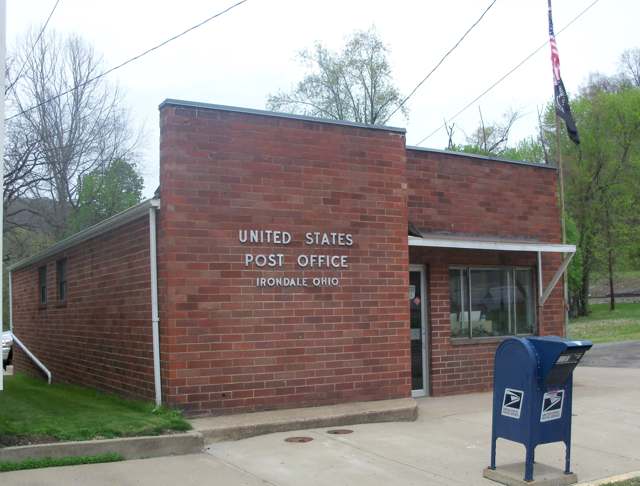
Photo: Roseohioresident, Wikimedia Commons, CC BY-SA 4.0 · Wikimedia Commons
Local history sources: en.wikipedia.org · ohiogenealogyexpress.com · commons.wikimedia.org · archive.org
Water
No water-system data is linked to Irondale's ZIP codes yet.
Hospitals, fire stations and more
Inside Irondale's boundary: 1 fire or EMS station, 1 poor-rated bridge and 1 spill case. Press a pin or a name for its whole record and its source.
Fire and EMS stations (1)
-
Irondale Fire DepartmentIrondale
- Address
- 142 Creek Street, Irondale, OH 43932
- Coordinates
- 40.57130, -80.72655
USGS National Map structures (source) ↗ Street map and directions ↗
Source: USGS National Map structures (most Ohio records last updated 2019 to 2022), checked against the Columbus and Cleveland station lists. The department that answers a call is set by jurisdiction and mutual aid, not by distance.
Bridges rated poor (1)
-
Reese Street over Salt RunPoor · built 1950
- Condition
- Poor: a deck, superstructure, substructure or culvert rated 4 or below on the 0 to 9 scale
- What it is
- Bridge
- Built
- 1950
- Length
- 7 ft
- Owner
- City
- Vehicles a day
- 100
- Coordinates
- 40.57244, -80.73019
National Bridge Inventory (source) ↗ Street map and directions ↗
Source: FHWA National Bridge Inventory 2025. "Poor" means one major part rated 4 or below on the 0 to 9 scale; it calls for repair, not closing, unless the state posts or closes the bridge.
Spills reported since 2021 (1)
-
Sheen Rainbow / Hydrocarbon Reached water2026-07-06 · Irondale
- Reported
- 2026-07-06
- What spilled
- Sheen Rainbow / Hydrocarbon
- Reached a waterway
- 41 - Yellow Creek
- Where
- Irondale, Jefferson County
- Ohio EPA district office
- SEDO
- Ohio EPA case number
- 2607EPA0001219
Ohio EPA spill reports (source) ↗ Street map and directions ↗
Source: Ohio EPA emergency response spill reports, 2021 to September 2026, one point per case where Ohio EPA placed it. A report is what the caller or responder recorded; amounts are often blank or estimated.
Its ZIP codes
Each ZIP code that touches Irondale, with the share of its residents who live here and the same headline figures as the ZIP page.
| ZIP | Share | Water | Radon | Home value | Schools | Flood |
|---|---|---|---|---|---|---|
| 43932 Saline Township and Irondale | 32% | Mostly private wells | 9.7 pCi/L average radon | Median year built 1950 | Edison Local · 4 stars overall | 6.4% of residents in the 1% floodplain |
Local government
Who holds office in Irondale, how its elections and ballot issues came out, and the state auditor's record.
Money issues on the ballot since 2019: 3 of 3 passed.
Ballot issues
| Date | Issue | For | Against | Result |
|---|---|---|---|---|
| 2024-11-05 | Issue 11: IRONDALE SURRENDER CORP | 23 | 112 | Failed (17.04% for), unofficial |
| 2022-11-08 | Issue 12: IRONDALE CURRENT EXPENSE | 56 | 16 | Passed (77.78% for) |
| 2019-11-05 | Issue 20: Irondale-Ren'l-Current Expenses-3 mills (3.0 mills) | 90 | 34 | Passed (72.58% for), unofficial |
| 2019-11-05 | Issue 21: Irondale-Ren'l-Current Expenses-4 mills (4.0 mills) | 89 | 36 | Passed (71.2% for), unofficial |
Elections for office
| Date | Office | Candidates and votes |
|---|---|---|
| 2023-11-07 | Member of Council | Michele Allen 61, 100.0% |
| 2023-11-07 | Mayor | William Allen 42, 43.75%; Timothy Sechrist 54, 56.25% |
| 2021-11-02 | Member of Council | Charles Allen 52, 28.42%; Cynthia Sechrist 40, 21.86%; Jason S. Smith 69, 37.7%; Kimberly Swisher 22, 12.02% |
| 2021-11-02 | Mayor | William D. Allen 38, 45.24%; Kenneth J. Stanley Jr. 46, 54.76% |
Winners in bold. Results from the county board of elections' official canvass unless marked.
Auditor of State record
- Fiscal emergency: declared 1985-10-09, released 1993-07-06. source
- Basic Audit, 2024 to 2025, released 2026-09-15
- Basic Audit, 2022 to 2023, released 2024-11-07
The county
Jefferson County: 21 ZIP codes, 33 cities, villages and townships, 67,859 people.
Nearby places
Rain and snow
How much has actually fallen on Irondale, day by day, from 1878 to now. Daily totals, not averages.
- rain, last 30 days
- 2.17 in
- 2026-09-30 to 2026-10-29
- rain so far in 2026
- 43.2 in
- 7.5 in above normal for the date
- snow so far in 2026
- 28.7 in
- a normal year brings 21.8 in
- a normal year
- 42.0 in
- average of 30 years, 1991-2020
| Month | Rain (in) | Snow (in) | Days counted |
|---|---|---|---|
| October 2026 | 2.17 | — | 29 |
| September 2026 | 6.06 | — | 30 |
| August 2026 | 7.62 | — | 31 |
| July 2026 | 4.82 | — | 31 |
| June 2026 | 4.10 | — | 30 |
| May 2026 | 4.86 | — | 31 |
| April 2026 | 4.62 | — | 30 |
| March 2026 | 5.57 | 4.3 | 31 |
| February 2026 | 1.03 | 4.5 | 28 |
| January 2026 | 2.29 | 19.8 | 31 |
| December 2025 | 2.55 | 11.1 | 31 |
| November 2025 | 1.92 | 0.1 | 30 |
| Wettest year | 2018 — 61.3 in |
|---|---|
| Driest year | 1930 — 27.0 in |
| Snowiest year | 1960 — 55.3 in |
| Wettest day on record | 20 September 1883 — 4.50 in |
| Heaviest snowfall in a day | 6 February 1878 — 15.98 in |
| Deepest snow on the ground | 26 November 1950 — 22.36 in |
Estimated, not measured. No rain gauge has ever stood inside Irondale, so every figure here is worked out from the gauges around it - the nearest ones weighted most. Treat them as close estimates rather than readings.
51,044 days of records, 1878-02-01 to 2026-10-29. Source: NOAA NCEI GHCN-Daily, 3,240 gauges in and around Ohio. A day is "gauged" when a gauge standing inside the boundary reported it, and the value is the mean of those gauges. Otherwise it is interpolated by inverse distance from every gauge reporting within 50 miles. Nothing is carried forward, back-filled or smoothed. Against NOAA nClimDiv county monthly precipitation over 136,848 complete county-months (checked 2026-10-31): correlation 0.9515, median absolute difference 0.217 in a month. Built 2026-10-31 from the Cracked Buckeye precipitation archive. Snow is the softer number — snowfall is measured by hand with a ruler, no agency publishes a gridded county snowfall series, and blowing snow defeats every observer.
Environmental permits and filings
What Ohio EPA has on file for Irondale: permits, inspections, violations, cleanups and the state loans behind sewer and water work. Every line links to the agency's own document.
- facilities and sites on file
- 1
- those placed on the map inside Irondale
| Program | Facilities and sites |
|---|---|
| Hazardous waste | 1 |
| Date | Facility or site | What |
|---|---|---|
| CA JOSEPH SERVICES | Hazardous waste notice of violation | |
| CA JOSEPH SERVICES | Hazardous waste notice of violation | |
| CA JOSEPH SERVICES | Hazardous waste inspection | |
| CA JOSEPH SERVICES | Hazardous waste compliance letter |
Source: Ohio EPA eDocument portal (edocpub.epa.ohio.gov), indexed 2026-10-14. Facilities are placed on the map from Ohio EPA's own map layers, EPA's Facility Registry, coordinates written in the filings, or a geocoded street address. A permit filed under a private person's name (most are household septic systems) is counted but never named, placed or linked; licenses for individual workers and open-burning notices are left out entirely.
Quick answers
What county is Irondale, Ohio in?
Irondale is a village in Jefferson County, Ohio, with 315 residents.
When was Irondale, Ohio founded?
Irondale was settled c. 1806 (Samuel Potts's salt operation, as Pottsdale); laid out 1861 (Huntersville laid out, per the 1910 county history); Wikipedia says Morgan & Hunter replatted it as Hunterville in 1869; incorporated not recorded. Founders on record: Samuel Potts (as Pottsdale); Morgan & Hunter (1869 replat). Source
How did Irondale, Ohio get its name?
Named Pottsdale for Samuel Potts, an early salt manufacturer, around 1806. Source
What ZIP code is Irondale, Ohio?
Most of Irondale is in ZIP code 43932.
Where does Irondale, Ohio get its water?
The main water source for Irondale: Mostly private wells.
Cite this page
Cite this page as:
Cracked Buckeye, "Irondale, Jefferson County", https://crackedbuckeye.com/place/irondale/, built 2026-10-31, accessed [date].
How to cite · Report a correction · Built 2026-10-31
