Local events in Grand Rapids
Nothing is posted for Grand Rapids itself yet; here is what is on within 10 miles. All local events in Grand Rapids
Know a calendar we should watch? Send the link
Checked October 20; the events page is refreshed daily.
History from Grand Rapids
People and inventions tied to this place, each with its sources. All people · All inventions
How Grand Rapids began
Grand Rapids began as Gilead, platted in 1833 on the Maumee River at the head of the rapids that gave the later town its name. An 1845 state dam built to raise water for the Miami and Erie Canal so angered local mill owners, who depended on the river's natural fall for power, that citizens tore it down; a side-cut canal built instead brought boat traffic and growth, and the village incorporated under the name Grand Rapids in 1855 (Wikipedia also gives 1885). The Maumee that made the town has also periodically flooded it, most dramatically in 1904 and again in a 1959 ice-jam flood that displaced about 130 residents.
Platted 1833, as Gilead, incorporated 1855 (formal village incorporation, per a secondary source, in 1885).
Where the name comes from
The village was originally platted and named Gilead in 1833. It was renamed Grand Rapids, for the rapids of the Maumee River at the site, when it incorporated under that name in 1855; the post office did not catch up to the change until 1868.
Before the town
Grand Rapids sits directly across the Maumee from Providence, in Lucas County, the site the county's own 1897 history identifies as a historic Ottawa village -- 'from hence we proceeded to the Ottawa Village [Providence, Lucas County]' -- visited by 18th-century travelers portaging around the river's rapids. That village itself lies outside Wood County, but the rapids that made both Gilead/Grand Rapids and Providence significant to river travelers, Native and later white, are the same stretch of water. No mound, earthwork or named Native village specific to the Wood County side of the river at Grand Rapids was found in any source consulted.
Nations recorded here: Ottawa, Wyandot.
Timeline
- — The village is platted under the name Gilead.
- — A post office named Gilead opens.
- — The State of Ohio builds a dam across the Maumee at Gilead to maintain water levels for the Miami and Erie Canal; angry local mill owners, who relied on the river's natural fall for power, tear it down.
- — A side-cut canal is built connecting Gilead to the main canal line, spurring a period of commercial growth.
- — The village incorporates under the name Grand Rapids.
- — The post office name changes from Gilead to Grand Rapids, catching up to the village's own 1855 renaming.
- — A major flood sends debris floating through downtown Grand Rapids along Front Street.
- — An ice-jam flood on the Maumee displaces about 130 Grand Rapids residents and causes substantial property damage.
Stories
The dam the town tore down
In 1845, the State of Ohio built a dam across the Maumee at Gilead to keep enough water in the Miami and Erie Canal for boat traffic. It was meant to help the region's commerce, but it directly threatened the mills already operating at Gilead, which depended on the river's natural rapids-driven fall to turn their wheels -- a dam that raised the water upstream flattened the very drop the mills existed to use. Local citizens did not wait for the state to reconsider: they tore the dam down themselves. The state's response, rather than rebuilding the dam, was to cut a side channel connecting the town directly to the main canal line, giving Gilead boat access without flooding its own millpower -- a compromise that fed a period of real growth and helped the town justify incorporating a decade later under a new name, Grand Rapids, for the very rapids its citizens had just fought to keep.
Photographs
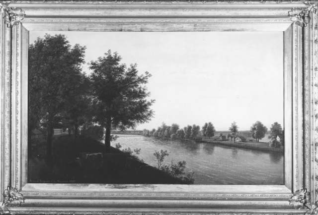
Photo: William H. Machen (painting, 1871); Kull Studio (photograph); Toledo Lucas County Public Library, via Digital Public Library of America, public domain · Wikimedia Commons
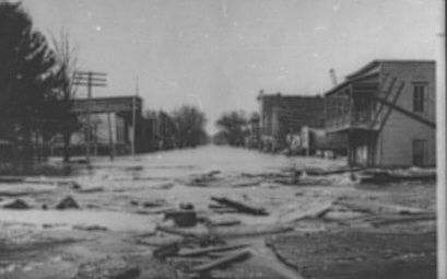
Photo: Toledo Lucas County Public Library, via Digital Public Library of America, public domain · Wikimedia Commons
Local history sources: en.wikipedia.org · archive.org · en.wikipedia.org · en.wikipedia.org · commons.wikimedia.org · commons.wikimedia.org
Historic places
5 places in Grand Rapids on the National Register of Historic Places. Press a pin or a name for its whole record.
-
Heeter-Russo HouseBuilding · Grand Rapids · listed 1975
- Address
- 24570 2nd St.
- Where
- Grand Rapids, Wood County · ZIP 43522
- What it is
- Building
- Listed on the National Register
- 1975
- NRIS reference number
- 75001554
- Coordinates
- 41.41034, -83.87416
National Register file (NPS) ↗ Search Wikipedia ↗ Street map and directions ↗ On the Cracked Buckeye map
-
Housley, R. A., HouseBuilding · Grand Rapids · listed 1996
- Address
- 24155 Front St.
- Where
- Grand Rapids, Wood County · ZIP 43522
- What it is
- Building
- Listed on the National Register
- 1996
- NRIS reference number
- 96000932
- Coordinates
- 41.41255, -83.86528
National Register file (NPS) ↗ Search Wikipedia ↗ Street map and directions ↗ On the Cracked Buckeye map
-
Kerr, Benjamin F., HouseBuilding · Grand Rapids · listed 1979
- Address
- 17605 Beaver St.
- Where
- Grand Rapids, Wood County · ZIP 43522
- What it is
- Building
- Listed on the National Register
- 1979
- NRIS reference number
- 79001982
- Coordinates
- 41.41032, -83.86793
National Register file (NPS) ↗ Search Wikipedia ↗ Street map and directions ↗ On the Cracked Buckeye map
-
Thurston BuildingBuilding · Grand Rapids · listed 1975
- Address
- Front St.
- Where
- Grand Rapids, Wood County · ZIP 43522
- What it is
- Building
- Listed on the National Register
- 1975
- NRIS reference number
- 75001555
- Coordinates
- 41.41213, -83.86754
National Register file (NPS) ↗ Search Wikipedia ↗ Street map and directions ↗ On the Cracked Buckeye map
-
Town HallBuilding · Grand Rapids · listed 1975
- Address
- Front St.
- Where
- Grand Rapids, Wood County · ZIP 43522
- What it is
- Building
- Listed on the National Register
- 1975
- NRIS reference number
- 75001556
- Coordinates
- 41.41227, -83.86883
National Register file (NPS) ↗ Search Wikipedia ↗ Street map and directions ↗ On the Cracked Buckeye map
Source: National Park Service, National Register of Historic Places point file. The listing year is shown where NPS's certification date agrees with the listing's reference number. Listing recognizes significance; it does not restrict a private owner.
Water
Mostly private wells The water here
- Grand Rapids Village95% of residentsMaumee River (via Bowling Green Reservoir)
- Whispering Winds Mhc5% of residentsGroundwater wells (1 wells)
Hospitals, fire stations and more
Inside Grand Rapids's boundary: 1 nursing home, 1 fire or EMS station, 1 library, 1 police station and 2 spill cases. Press a pin or a name for its whole record and its source.
Nursing homes (1)
-
Grand Rapids Care Center5 of 5 stars · Grand Rapids
- Address
- 24201 W 3Rd St, Grand Rapids, OH 43522
- Certified beds
- 32
- Residents on an average day
- 31
- Medicare overall rating
- 5 of 5 stars
- Health inspections
- 4 of 5 stars
- Staffing
- 3 of 5 stars
- Quality measures
- 5 of 5 stars
- Penalties since 2023
- none
- Ownership
- For profit - Corporation
- Chain
- SABER HEALTHCARE GROUP
- Takes
- Medicare and Medicaid
- Phone
- (419) 832-5195
- Medicare ID
- 366181
Medicare Care Compare ↗ CMS nursing home data (source) ↗ Street map and directions ↗
Source: CMS Care Compare nursing home provider and penalties files; Medicare star ratings run 1 to 5.
Fire and EMS stations (1)
-
Grand Rapids Township Fire DepartmentGrand Rapids
- Address
- 17706 Wapakoneta Road, Grand Rapids, OH 43522
- Coordinates
- 41.41108, -83.86366
USGS National Map structures (source) ↗ Street map and directions ↗
Source: USGS National Map structures (most Ohio records last updated 2019 to 2022), checked against the Columbus and Cleveland station lists. The department that answers a call is set by jurisdiction and mutual aid, not by distance.
Public libraries (1)
-
Grand Rapids Branch LibraryBranch · Grand Rapids
- Address
- 17620 Bridge St, Grand Rapids, OH 43522
- What it is
- Branch
- Library system
- Weston Public Library
- Open
- 2,080 hours a year, 52 weeks
- Building
- 5,663 sq ft
- System's visits, FY2024
- 11,544
- System's loans, FY2024
- 77,823
- People the system serves
- 8,272
- Phone
- (419) 832-5231
IMLS Public Libraries Survey (source) ↗ Street map and directions ↗
Source: IMLS Public Libraries Survey FY2024 (outlets and their systems). Any Ohio resident can get a free card at any Ohio public library.
Police stations (1)
-
Grand Rapids Police DepartmentGrand Rapids
- Address
- 23564 Front Street, Grand Rapids, OH 43522
- Coordinates
- 41.41305, -83.85548
USGS National Map structures (source) ↗ Street map and directions ↗
Source: USGS National Map structures, police stations, corrected and completed by hand (September 2026). The department that answers a call is set by jurisdiction, not by distance.
Spills reported since 2021 (2)
-
Fuel Diesel / Diesel Fuel (Vehicle On Or Off Road) Reached water2024-04-15 · Grand Rapids Twp
- Reported
- 2024-04-15
- What spilled
- Fuel Diesel / Diesel Fuel (Vehicle On Or Off Road)
- Largest amount reported
- 3 gallons
- Reached a waterway
- 87 - Maumee River
- Where
- Grand Rapids Twp, Wood County
- Ohio EPA district office
- NWDO
- Ohio EPA case number
- 2404EPA0000626
Ohio EPA spill reports (source) ↗ Street map and directions ↗
-
Fuel Diesel / Diesel Fuel (Vehicle On Or Off Road)2021-06-16 · Grand Rapids
- Reported
- 2021-06-16
- What spilled
- Fuel Diesel / Diesel Fuel (Vehicle On Or Off Road)
- Where
- Grand Rapids, Wood County
- Ohio EPA district office
- NWDO
- Ohio EPA case number
- 2106EPA0000869
Ohio EPA spill reports (source) ↗ Street map and directions ↗
Source: Ohio EPA emergency response spill reports, 2021 to September 2026, one point per case where Ohio EPA placed it. A report is what the caller or responder recorded; amounts are often blank or estimated.
Its ZIP codes
Each ZIP code that touches Grand Rapids, with the share of its residents who live here and the same headline figures as the ZIP page.
| ZIP | Share | Water | Radon | Home value | Schools | Flood |
|---|---|---|---|---|---|---|
| 43522 Providence Township and Grand Rapids | 28% | Mostly private wells | 3.4 pCi/L average radon | Appraisal records without year built | Otsego Local · 4 stars overall | 6.0% of residents in the 1% floodplain |
Local government
Who holds office in Grand Rapids, how its elections and ballot issues came out, and the state auditor's record.
Money issues on the ballot since 2021: 1 of 1 passed.
Ballot issues
| Date | Issue | For | Against | Result |
|---|---|---|---|---|
| 2021-11-02 | Issue: Grand Rapids Village - Renewal 2 Mills (2.0 mills, renewal) | 115 | 25 | Passed (82.14% for) |
Elections for office
| Date | Office | Candidates and votes |
|---|---|---|
| 2025-11-04 | Council | Nathan Bolton 89, 8.45%; Jody K. Donsbach 173, 16.43%; Louise M. Estep 218, 20.7%; Douglas J. Grey 142, 13.49%; Patrick Nagle 80, 7.6%; Lynn C. Sylvain 50, 4.75%; Sean Thiebaut 167, 15.86%; Matthew Tolles 134, 12.73% |
Winners in bold. Results from the county board of elections' official canvass unless marked.
Auditor of State record
- No fiscal caution, watch or emergency on the Auditor of State's lists.
- Financial Audit, 2022 to 2023, released 2024-11-19
The county
Wood County: 28 ZIP codes, 42 cities, villages and townships, 132,052 people.
Nearby places
Rain and snow
How much has actually fallen on Grand Rapids, day by day, from 1893 to now. Daily totals, not averages.
- rain, last 30 days
- 1.82 in
- 2026-09-30 to 2026-10-29
- rain so far in 2026
- 35.1 in
- 5.2 in above normal for the date
- snow so far in 2026
- 15.8 in
- a normal year brings 29.8 in
- a normal year
- 34.9 in
- average of 30 years, 1991-2020
| Month | Rain (in) | Snow (in) | Days counted |
|---|---|---|---|
| October 2026 | 1.82 | — | 29 |
| September 2026 | 3.16 | — | 30 |
| August 2026 | 5.48 | — | 31 |
| July 2026 | 3.31 | — | 31 |
| June 2026 | 5.51 | — | 30 |
| May 2026 | 2.23 | — | 31 |
| April 2026 | 7.52 | — | 30 |
| March 2026 | 4.15 | 0.1 | 31 |
| February 2026 | 0.77 | 2.2 | 28 |
| January 2026 | 1.15 | 13.5 | 31 |
| December 2025 | 1.69 | 6.8 | 31 |
| November 2025 | 1.72 | 6.1 | 30 |
| Wettest year | 2011 — 53.8 in |
|---|---|
| Driest year | 1963 — 21.8 in |
| Snowiest year | 2014 — 80.5 in |
| Wettest day on record | 18 October 1988 — 3.68 in |
| Heaviest snowfall in a day | 28 February 1900 — 13.26 in |
| Deepest snow on the ground | 12 January 1918 — 22.01 in |
Estimated, not measured. No rain gauge has ever stood inside Grand Rapids, so every figure here is worked out from the gauges around it - the nearest ones weighted most. Treat them as close estimates rather than readings.
48,808 days of records, 1893-01-01 to 2026-10-29. Source: NOAA NCEI GHCN-Daily, 3,240 gauges in and around Ohio. A day is "gauged" when a gauge standing inside the boundary reported it, and the value is the mean of those gauges. Otherwise it is interpolated by inverse distance from every gauge reporting within 50 miles. Nothing is carried forward, back-filled or smoothed. Against NOAA nClimDiv county monthly precipitation over 136,848 complete county-months (checked 2026-10-31): correlation 0.9515, median absolute difference 0.217 in a month. Built 2026-10-31 from the Cracked Buckeye precipitation archive. Snow is the softer number — snowfall is measured by hand with a ruler, no agency publishes a gridded county snowfall series, and blowing snow defeats every observer.
Environmental permits and filings
What Ohio EPA has on file for Grand Rapids: permits, inspections, violations, cleanups and the state loans behind sewer and water work. Every line links to the agency's own document.
- facilities and sites on file
- 2
- those placed on the map inside Grand Rapids
| Program | Facilities and sites |
|---|---|
| State water loans | 1 |
| Wastewater and stormwater discharge | 1 |
| Date | Facility or site | What |
|---|---|---|
| RIVER'S CROSSING PLAT 1A | Wastewater and stormwater discharge permit | |
| GRAND RAPIDS VILLAGE | State water loans | |
| GRAND RAPIDS VILLAGE | State water loans |
Source: Ohio EPA eDocument portal (edocpub.epa.ohio.gov), indexed 2026-10-14. Facilities are placed on the map from Ohio EPA's own map layers, EPA's Facility Registry, coordinates written in the filings, or a geocoded street address. A permit filed under a private person's name (most are household septic systems) is counted but never named, placed or linked; licenses for individual workers and open-burning notices are left out entirely.
Quick answers
What county is Grand Rapids, Ohio in?
Grand Rapids is a village in Wood County, Ohio, with 925 residents.
When was Grand Rapids, Ohio founded?
Grand Rapids was laid out 1833, as Gilead; incorporated 1855 (formal village incorporation, per a secondary source, in 1885). Source
How did Grand Rapids, Ohio get its name?
The village was originally platted and named Gilead in 1833. Source
What ZIP code is Grand Rapids, Ohio?
Most of Grand Rapids is in ZIP code 43522.
Where does Grand Rapids, Ohio get its water?
The main water source for Grand Rapids (Grand Rapids Village): Mostly private wells.
Cite this page
Cite this page as:
Cracked Buckeye, "Grand Rapids, Wood County", https://crackedbuckeye.com/place/grand-rapids/, built 2026-10-31, accessed [date].
How to cite · Report a correction · Built 2026-10-31
