Local events in Fredericktown
10 events in the next 90 days from 3 public calendars. All local events in Fredericktown
Checked October 20; the events page is refreshed daily.
How Fredericktown began
Fredericktown was laid out in November 1807 by John Kerr, a Quaker settler who dammed the east fork of Owl Creek (the Kokosing River) and built a mill on 50 acres given to him by land speculator Lucas Sullivant. William Y. Farquhar, a fellow Quaker from Maryland, surveyed and platted the village and named it Frederick in honor of his old home there. The site had already been a center of Adena mound-building activity more than two thousand years earlier, and downtown Fredericktown's public square sits where one of those earthworks once stood. The village grew as a mill and market town, was rebuilt in brick after fires in 1875 and 1913, and today its late-1800s residential and commercial core is documented on the National Register of Historic Places as a set of two dozen individually listed buildings.
Settled 1806-1807 (Quaker families from Maryland), platted November 1807, by John Kerr (mill site); platted and named by William Y. Farquhar.
Where the name comes from
William Y. Farquhar, who surveyed and platted the village, named the town Frederick in honor of his old home in Maryland.
Before the town
No named historic-era Native village or resident is recorded specifically at Fredericktown; the county-level history notes only that Knox County held a few scattered Delaware villages and was more a crossing-ground than a settled center for any one nation before removal. Two Indian trails are recorded as crossing the immediate area before Quaker settlement began in 1806. The deeper record here is prehistoric rather than historic-era: Fredericktown sits at the head of the Kokosing River in what was, roughly 1000 BC to 200 BC, an active center of Adena mound-building. Three mounds/earthworks are recorded at or near the village; one, a crescent-shaped enclosure about 275 by 300 feet, stood exactly where the downtown public square now sits and was leveled by the town's founders to build the village.
Nations recorded here: Delaware (Lenape), Wyandot, Adena culture.
- Downtown Square enclosure (earthwork) — Fredericktown's public square, Adena, c. 1000-200 BC (ashlandsource.com)
- Braddock Mound (mound) — north side of Montgomery Road, across the Kokosing River from Fredericktown; NRHP-listed 1973, Adena, c. 1000-200 BC (ashlandsource.com)
- Rowley Mound (Raleigh Mound) (mound) — south side of West Mound Street, Fredericktown; NRHP-listed 1975, Adena, c. 1000-200 BC (ashlandsource.com)
Timeline
- — A group of Quaker (Friends) families from the vicinity of Frederick, Maryland, including John Kerr and William Y. Farquhar, begin settling the site on the east fork of Owl Creek.
- — John Kerr lays out a town on the bluff above the west bank of Owl Creek after building a mill dam; William Y. Farquhar surveys and plats the village and names it Frederick.
- — The village has grown to nine log cabins and one frame building, which housed the first store; blockhouses are built in the area during the War of 1812.
- — A post office is established at Fredericktown.
- — The Sandusky, Mansfield and Newark Railroad opens through the village.
- — A major fire destroys part of the downtown, which is subsequently rebuilt in brick.
- — The landowner of the Rowley Mound removes about 100 loads of earth from the mound for fill, uncovering two skeletons.
- — A second major fire strikes the village, prompting further brick rebuilding of the commercial core.
- — Twenty-two individual buildings and one earlier-listed mound in and around Fredericktown are added to the National Register of Historic Places as part of a Multiple Resource Area submission, including the Samuel Beers House, Bell House, Brick Commercial Block, William Burch House, Henry Cassell House, Wilson S. Cummings House, Elias Delashment House, Old Davis and Dague Grocery Store, and Fredericktown Presbyterian Church.
Stories
The mound the town leveled to build its square
More than two thousand years before John Kerr dammed Owl Creek, people of the Adena culture built a crescent-shaped earthen enclosure roughly 275 feet wide and 300 feet long on the ground that would become Fredericktown's downtown. Early historians described it as three to five feet high, a low curving wall rather than a burial mound. When the Quaker settlers laid out their village in 1807, the earthwork stood in the way of the town plat, and they leveled it to build the public square around which Fredericktown's commercial district still stands. Two other Adena mounds nearby survived: the Braddock Mound, on a bluff across the Kokosing River, and the Rowley Mound on West Mound Street, both later added to the National Register of Historic Places. In 1892 the owner of the Rowley Mound carted off about a hundred loads of dirt for fill and turned up two skeletons in the process, a reminder of what had already been lost at the square a century before.
A Maryland name on an Ohio mill town
Fredericktown's founders were Quakers who had left the country around Frederick, Maryland, and followed family and faith connections west. John Kerr, one of them, in the fall of 1807 built a dam and a log mill on fifty acres given to him by Lucas Sullivant, the Columbus-area land speculator who held a large tract along Owl Creek. William Y. Farquhar, Kerr's fellow Marylander, surveyed the streets and lots that fall and gave the new village the name of the town he had left behind. By 1812 the settlement counted nine log cabins and a single frame building that doubled as its first store, and the road to Mount Vernon, laid out in 1809, tied it into the rest of the county.
Photographs
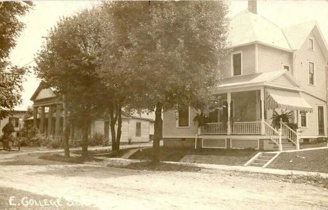
Photo: Real photo postcard, photographer unknown, public domain · Wikimedia Commons
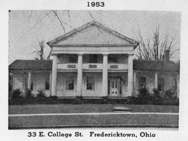
Photo: SnyderFH (Commons upload), CC BY-SA 4.0 · Wikimedia Commons
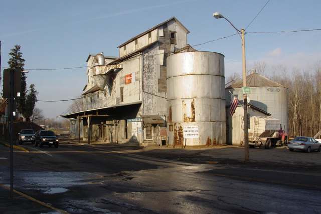
Photo: Seth a (Wikipedia/Commons user), public domain · Wikimedia Commons
Local history sources: en.wikipedia.org · fredericktownmuseum.com · ashlandsource.com · en.wikipedia.org · en.wikipedia.org · en.wikipedia.org · knoxpages.com · commons.wikimedia.org · commons.wikimedia.org · commons.wikimedia.org · commons.wikimedia.org
Historic places
23 places in Fredericktown on the National Register of Historic Places. Press a pin or a name for its whole record.
-
Beers, Samuel, HouseBuilding · Fredericktown · listed 1979
- Address
- W. Sandusky St.
- Where
- Fredericktown, Knox County · ZIP 43019
- What it is
- Building
- Listed on the National Register
- 1979
- NRIS reference number
- 79003855
- Coordinates
- 40.48041, -82.55223
National Register file (NPS) ↗ Search Wikipedia ↗ Street map and directions ↗ On the Cracked Buckeye map
-
Bell HouseBuilding · Fredericktown · listed 1979
- Address
- 53--57 N. Main St.
- Where
- Fredericktown, Knox County · ZIP 43019
- What it is
- Building
- Listed on the National Register
- 1979
- NRIS reference number
- 79003856
- Coordinates
- 40.48197, -82.54353
National Register file (NPS) ↗ Search Wikipedia ↗ Street map and directions ↗ On the Cracked Buckeye map
-
Brick Commercial BlockBuilding · Fredericktown · listed 1979
- Address
- Main and College Sts.
- Where
- Fredericktown, Knox County · ZIP 43019
- What it is
- Building
- Listed on the National Register
- 1979
- NRIS reference number
- 79003857
- Coordinates
- 40.48269, -82.54355
National Register file (NPS) ↗ Search Wikipedia ↗ Street map and directions ↗ On the Cracked Buckeye map
-
Burch, William, HouseBuilding · Fredericktown · listed 1979
- Address
- Edgehill Dr. and Mount Vernon Ave.
- Where
- Fredericktown, Knox County · ZIP 43019
- What it is
- Building
- Listed on the National Register
- 1979
- NRIS reference number
- 79003858
- Coordinates
- 40.48039, -82.54043
National Register file (NPS) ↗ Search Wikipedia ↗ Street map and directions ↗ On the Cracked Buckeye map
-
Cassell, Henry, HouseBuilding · Fredericktown · listed 1979
- Address
- 23 High St.
- Where
- Fredericktown, Knox County · ZIP 43019
- What it is
- Building
- Listed on the National Register
- 1979
- NRIS reference number
- 79003859
- Coordinates
- 40.48412, -82.54429
National Register file (NPS) ↗ Search Wikipedia ↗ Street map and directions ↗ On the Cracked Buckeye map
-
Cummings, Wilson S., HouseBuilding · Fredericktown · listed 1979
- Address
- Sandusky and Taylor Sts.
- Where
- Fredericktown, Knox County · ZIP 43019
- What it is
- Building
- Listed on the National Register
- 1979
- NRIS reference number
- 79003860
- Coordinates
- 40.48147, -82.54753
National Register file (NPS) ↗ Search Wikipedia ↗ Street map and directions ↗ On the Cracked Buckeye map
-
Davis and Dague Grocery Store, OldBuilding · Fredericktown · listed 1979
- Address
- Main and College Sts.
- Where
- Fredericktown, Knox County · ZIP 43019
- What it is
- Building
- Listed on the National Register
- 1979
- NRIS reference number
- 79003869
- Coordinates
- 40.48261, -82.54284
National Register file (NPS) ↗ Search Wikipedia ↗ Street map and directions ↗ On the Cracked Buckeye map
-
Delashment, Elias, HouseBuilding · Fredericktown · listed 1979
- Address
- Second St. and Edgehill Dr.
- Where
- Fredericktown, Knox County · ZIP 43019
- What it is
- Building
- Listed on the National Register
- 1979
- NRIS reference number
- 79003861
- Coordinates
- 40.48147, -82.54069
National Register file (NPS) ↗ Search Wikipedia ↗ Street map and directions ↗ On the Cracked Buckeye map
-
Early Greek Revival CottageBuilding · Fredericktown · listed 1979
- Address
- Secon and Chestnut Sts.
- Where
- Fredericktown, Knox County · ZIP 43019
- What it is
- Building
- Listed on the National Register
- 1979
- NRIS reference number
- 79003862
- Coordinates
- 40.48205, -82.54460
National Register file (NPS) ↗ Search Wikipedia ↗ Street map and directions ↗ On the Cracked Buckeye map
-
Early Greek Revival HouseBuilding · Fredericktown · listed 1979
- Address
- Main and Second Sts.
- Where
- Fredericktown, Knox County · ZIP 43019
- What it is
- Building
- Listed on the National Register
- 1979
- NRIS reference number
- 79003863
- Coordinates
- 40.48189, -82.54294
National Register file (NPS) ↗ Search Wikipedia ↗ Street map and directions ↗ On the Cracked Buckeye map
-
Fredericktown Presbyterian ChurchBuilding · Fredericktown · listed 1979
- Address
- Main St. and Public Sq.
- Where
- Fredericktown, Knox County · ZIP 43019
- What it is
- Building
- Listed on the National Register
- 1979
- NRIS reference number
- 79003864
- Coordinates
- 40.48062, -82.54362
National Register file (NPS) ↗ Search Wikipedia ↗ Street map and directions ↗ On the Cracked Buckeye map
-
Gothic Revival HouseBuilding · Fredericktown · listed 1979
- Address
- High and N. Main Sts.
- Where
- Fredericktown, Knox County · ZIP 43019
- What it is
- Building
- Listed on the National Register
- 1979
- NRIS reference number
- 79003865
- Coordinates
- 40.48359, -82.54380
National Register file (NPS) ↗ Search Wikipedia ↗ Street map and directions ↗ On the Cracked Buckeye map
-
Greek Revival Commercial BuildingBuilding · Fredericktown · listed 1979
- Address
- 67--69 N. Main St.
- Where
- Fredericktown, Knox County · ZIP 43019
- What it is
- Building
- Listed on the National Register
- 1979
- NRIS reference number
- 79003866
- Coordinates
- 40.48215, -82.54354
National Register file (NPS) ↗ Search Wikipedia ↗ Street map and directions ↗ On the Cracked Buckeye map
-
Greek Revival Farmhouse, OldBuilding · Fredericktown · listed 1979
- Address
- W. Sandusky St.
- Where
- Fredericktown, Knox County · ZIP 43019
- What it is
- Building
- Listed on the National Register
- 1979
- NRIS reference number
- 79003870
- Coordinates
- 40.48063, -82.54964
National Register file (NPS) ↗ Search Wikipedia ↗ Street map and directions ↗ On the Cracked Buckeye map
-
Hosack HouseBuilding · Fredericktown · listed 1979
- Address
- W. College St.
- Where
- Fredericktown, Knox County · ZIP 43019
- What it is
- Building
- Listed on the National Register
- 1979
- NRIS reference number
- 79003867
- Coordinates
- 40.48233, -82.54366
National Register file (NPS) ↗ Search Wikipedia ↗ Street map and directions ↗ On the Cracked Buckeye map
-
King, Dr., HouseBuilding · Fredericktown · listed 1979
- Address
- Main and Second Sts.
- Where
- Fredericktown, Knox County · ZIP 43019
- What it is
- Building
- Listed on the National Register
- 1979
- NRIS reference number
- 79003868
- Coordinates
- 40.48161, -82.54352
National Register file (NPS) ↗ Search Wikipedia ↗ Street map and directions ↗ On the Cracked Buckeye map
-
Methodist Church, OldBuilding · Fredericktown · listed 1979
- Address
- Sandusky St. and Public Sq.
- Where
- Fredericktown, Knox County · ZIP 43019
- What it is
- Building
- Listed on the National Register
- 1979
- NRIS reference number
- 79003871
- Coordinates
- 40.48090, -82.54268
National Register file (NPS) ↗ Search Wikipedia ↗ Street map and directions ↗ On the Cracked Buckeye map
-
Reed, James, HouseBuilding · Fredericktown · listed 1979
- Address
- E. College St.
- Where
- Fredericktown, Knox County · ZIP 43019
- What it is
- Building
- Listed on the National Register
- 1979
- NRIS reference number
- 79003873
- Coordinates
- 40.48263, -82.54142
National Register file (NPS) ↗ Search Wikipedia ↗ Street map and directions ↗ On the Cracked Buckeye map
-
Second Hosack HouseBuilding · Fredericktown · listed 1979
- Address
- College and Chestnut Sts.
- Where
- Fredericktown, Knox County · ZIP 43019
- What it is
- Building
- Listed on the National Register
- 1979
- NRIS reference number
- 79003874
- Coordinates
- 40.48232, -82.54413
National Register file (NPS) ↗ Search Wikipedia ↗ Street map and directions ↗ On the Cracked Buckeye map
-
Sprague--Deaver HouseBuilding · Fredericktown · listed 1979
- Address
- Sandusky and Pleasant Sts.
- Where
- Fredericktown, Knox County · ZIP 43019
- What it is
- Building
- Listed on the National Register
- 1979
- NRIS reference number
- 79003875
- Coordinates
- 40.48081, -82.54244
National Register file (NPS) ↗ Search Wikipedia ↗ Street map and directions ↗ On the Cracked Buckeye map
-
Telephone Building, OldBuilding · Fredericktown · listed 1979
- Address
- College and Chestnut Sts.
- Where
- Fredericktown, Knox County · ZIP 43019
- What it is
- Building
- Listed on the National Register
- 1979
- NRIS reference number
- 79003872
- Coordinates
- 40.48268, -82.54414
National Register file (NPS) ↗ Search Wikipedia ↗ Street map and directions ↗ On the Cracked Buckeye map
-
Tuttle HouseBuilding · Fredericktown · listed 1976
- Address
- 33 E. College St.
- Where
- Fredericktown, Knox County · ZIP 43019
- What it is
- Building
- Listed on the National Register
- 1976
- NRIS reference number
- 76001458
- Coordinates
- 40.48244, -82.54189
National Register file (NPS) ↗ Search Wikipedia ↗ Street map and directions ↗ On the Cracked Buckeye map
-
Wright, Lyman, BuildingBuilding · Fredericktown · listed 1979
- Address
- Main and Second Sts.
- Where
- Fredericktown, Knox County · ZIP 43019
- What it is
- Building
- Listed on the National Register
- 1979
- NRIS reference number
- 79003876
- Coordinates
- 40.48162, -82.54305
National Register file (NPS) ↗ Search Wikipedia ↗ Street map and directions ↗ On the Cracked Buckeye map
Source: National Park Service, National Register of Historic Places point file. The listing year is shown where NPS's certification date agrees with the listing's reference number. Listing recognizes significance; it does not restrict a private owner.
Water
Mostly private wells The water here
- Fredericktown Village74% of residentsGroundwater wells (3 wells)
- Del-co Water Company, Inc.26% of residentsOlentangy River, O'Shaughnessy and Alum Creek reservoirs, plus Knox County wells
Hospitals, fire stations and more
Inside Fredericktown's boundary: 1 fire or EMS station, 3 public schools, 1 library, 1 museum, 1 police station, 1 public charging site and 1 spill case. Press a pin or a name for its whole record and its source.
Fire and EMS stations (1)
-
Fredericktown Community Fire StationFredericktown
- Address
- 139 Columbus Road, Fredericktown, OH 43019
- Coordinates
- 40.47347, -82.54902
USGS National Map structures (source) ↗ Street map and directions ↗
Source: USGS National Map structures (most Ohio records last updated 2019 to 2022), checked against the Columbus and Cleveland station lists. The department that answers a call is set by jurisdiction and mutual aid, not by distance.
Public schools (3)
-
Fredericktown Elementary School4 of 5 stars · Fredericktown
- Address
- 111 Stadium Drive, Fredericktown, OH 43019
- School district
- Fredericktown Local School District
- Kind (NCES)
- Regular School
- Students, 2023-24
- 564
- Teachers (full-time equivalent)
- 28
- Report card, 2025-26
- 4 of 5 stars
- Performance index
- 83.1%
- Ohio building IRN
- 012443
- NCES school ID
- 390478503012
NCES school record ↗ Ohio School Report Card ↗ Street map and directions ↗
-
Fredericktown High School4 of 5 stars · Fredericktown
- Address
- 111 Stadium Dr, Fredericktown, OH 43019
- School district
- Fredericktown Local School District
- Kind (NCES)
- Regular School
- Students, 2023-24
- 331
- Teachers (full-time equivalent)
- 17
- Report card, 2025-26
- 4 of 5 stars
- Performance index
- 84%
- Four-year graduation rate
- 99.1%
- Ohio building IRN
- 012450
- NCES school ID
- 390478503013
NCES school record ↗ Ohio School Report Card ↗ Street map and directions ↗
-
Fredericktown Middle School3.5 of 5 stars · Fredericktown
- Address
- 111 Stadium Dr, Fredericktown, OH 43019
- School district
- Fredericktown Local School District
- Kind (NCES)
- Regular School
- Students, 2023-24
- 260
- Teachers (full-time equivalent)
- 15
- Report card, 2025-26
- 3.5 of 5 stars
- Performance index
- 78.4%
- Ohio building IRN
- 062380
- NCES school ID
- 390478503014
NCES school record ↗ Ohio School Report Card ↗ Street map and directions ↗
Source: NCES EDGE public school locations 2024-25 and Common Core of Data 2023-24 (type, students, teachers); Ohio School Report Cards 2025-26 (Department of Education and Workforce), matched by name within the district.
Public libraries (1)
-
Fredericktown BranchBranch · Fredericktown
- Address
- 1 Burgett Dr, Fredericktown, OH 43019
- What it is
- Branch
- Library system
- Mt Vernon & Knox County, Public Library Of
- Open
- 2,343 hours a year, 52 weeks
- Building
- 8,100 sq ft
- System's visits, FY2024
- 337,376
- System's loans, FY2024
- 392,438
- People the system serves
- 56,248
- Phone
- (740) 694-2665
IMLS Public Libraries Survey (source) ↗ Street map and directions ↗
Source: IMLS Public Libraries Survey FY2024 (outlets and their systems). Any Ohio resident can get a free card at any Ohio public library.
Museums, historical societies, gardens and zoos (1)
-
Fredericktown Historical SocietyHistorical society · Fredericktown
- What it is
- Historical society
- City
- Fredericktown
- Coordinates
- 40.48080, -82.54254
Search Wikipedia ↗ IMLS Museum Data Files (source) ↗ Street map and directions ↗
The museum list is IMLS's 2018 file; a museum may have closed or moved since.
Source: IMLS Museum Data Files, 2018.
Police stations (1)
-
Fredericktown Police DepartmentFredericktown
- Address
- 182 South Main Street, Fredericktown, OH 43019
- Coordinates
- 40.47410, -82.54099
Where this record comes from ↗ USGS National Map structures (source) ↗ Street map and directions ↗
Source: USGS National Map structures, police stations, corrected and completed by hand (September 2026). The department that answers a call is set by jurisdiction, not by distance.
Public EV charging (1)
-
Fredericktown Splash Pad2 Level 2 · FREDERICKTOWN
- Address
- 69 N. MAIN ST., FREDERICKTOWN, OH 43019
- Ports
- 2 Level 2
- Plugs
- J1772
- Network
- FLO
- Hours
- 24 hours daily
- Phone
- 888-356-8911
Station Locator (NREL) ↗ Alternative Fuels Data Center (source) ↗ Street map and directions ↗
Source: NREL Alternative Fuels Data Center station list (May 2026), public and open stations, the posts at one address counted as one site.
Spills reported since 2021 (1)
-
Sheen Rainbow / Hydrocarbon Reached water2025-10-03 · Fredericktown
- Reported
- 2025-10-03
- What spilled
- Sheen Rainbow / Hydrocarbon
- Reached a waterway
- 42 - Kokosing River
- Where
- Fredericktown, Knox County
- Ohio EPA district office
- CDO
- Ohio EPA case number
- 2510EPA0001636
Ohio EPA spill reports (source) ↗ Street map and directions ↗
Source: Ohio EPA emergency response spill reports, 2021 to September 2026, one point per case where Ohio EPA placed it. A report is what the caller or responder recorded; amounts are often blank or estimated.
Its ZIP codes
Each ZIP code that touches Fredericktown, with the share of its residents who live here and the same headline figures as the ZIP page.
| ZIP | Share | Water | Radon | Home value | Schools | Flood |
|---|---|---|---|---|---|---|
| 43019 Fredericktown | 28% | Mostly private wells | 8.7 pCi/L average radon | Median year built 1972 | Fredericktown Local · 4 stars overall | 3.1% of residents in the 1% floodplain |
Local government
Who holds office in Fredericktown, how its elections and ballot issues came out, and the state auditor's record.
Money issues on the ballot since 2019: 2 of 2 passed.
Ballot issues
| Date | Issue | For | Against | Result |
|---|---|---|---|---|
| 2025-11-04 | Issue: Proposed Tax Levy(Renewal) FREDERICKTOWN | 266 | 112 | Passed (70.37% for), unofficial |
| 2020-11-03 | Issue: Fredericktown Village | 917 | 379 | Passed (70.76% for) |
| 2019-11-05 | Issue: Fredericktown Village Renewal | 309 | 162 | Passed (65.61% for) |
Elections for office
| Date | Office | Candidates and votes |
|---|---|---|
| 2025-11-04 | Member of Council (unofficial count) | Richard J. Lanuzza 241, 30.12%; Sabrina C. Pugh 237, 29.62%; Ryan Shoemaker 278, 34.75%; Write-In: Chris Cline 0 |
| 2025-11-04 | Member of Council (unofficial count) | Raymond Paul Brewer 246, 49.5%; Scott Allen McKnight 251, 50.5% |
| 2023-11-07 | Mayor | Jerry L. Day 817, 100.0% |
| 2021-11-02 | Member of Council | Mollie de Rojas 311, 19.77%; Rita Fenton 268, 17.04%; James W. Hobson 271, 17.23%; Richard J. Lanuzza 350, 22.25%; Ryan Shoemaker 373, 23.71% |
| 2019-11-05 | Member of Council | Ray Brewer 349, 55.13%; Douglas Turpen 284, 44.87% |
| 2019-11-05 | Mayor | Jerry Day 423, 100.0% |
Winners in bold. Results from the county board of elections' official canvass unless marked.
Auditor of State record
- No fiscal caution, watch or emergency on the Auditor of State's lists.
- Agreed Upon Procedures, 2024 to 2025, released 2026-08-11
- Financial Audit, 2022 to 2023, released 2024-12-26
The county
Knox County: 8 ZIP codes, 28 cities, villages and townships, 62,928 people.
Nearby places
Rain and snow
How much has actually fallen on Fredericktown, day by day, from 1892 to now. Daily totals, not averages.
- rain, last 30 days
- 1.18 in
- 2026-09-30 to 2026-10-29
- rain so far in 2026
- 39.9 in
- about normal for the date
- snow so far in 2026
- 24.0 in
- a normal year brings 35.0 in
- a normal year
- 48.2 in
- average of 30 years, 1991-2020
| Month | Rain (in) | Snow (in) | Days counted |
|---|---|---|---|
| October 2026 | 1.18 | — | 29 |
| September 2026 | 4.50 | — | 30 |
| August 2026 | 7.27 | — | 31 |
| July 2026 | 3.29 | — | 31 |
| June 2026 | 3.55 | — | 30 |
| May 2026 | 6.72 | — | 31 |
| April 2026 | 5.08 | — | 30 |
| March 2026 | 4.79 | 1.1 | 31 |
| February 2026 | 1.49 | 5.4 | 28 |
| January 2026 | 2.00 | 17.5 | 31 |
| December 2025 | 2.80 | 12.2 | 31 |
| November 2025 | 2.09 | 1.8 | 30 |
| Wettest year | 2011 — 75.0 in |
|---|---|
| Driest year | 1963 — 25.1 in |
| Snowiest year | 2003 — 70.6 in |
| Wettest day on record | 14 September 1979 — 4.73 in |
| Heaviest snowfall in a day | 5 April 1987 — 10.77 in |
| Deepest snow on the ground | 28 January 1918 — 20.00 in |
Estimated, not measured. No rain gauge has ever stood inside Fredericktown, so every figure here is worked out from the gauges around it - the nearest ones weighted most. Treat them as close estimates rather than readings.
48,907 days of records, 1892-12-01 to 2026-10-29. Source: NOAA NCEI GHCN-Daily, 3,240 gauges in and around Ohio. A day is "gauged" when a gauge standing inside the boundary reported it, and the value is the mean of those gauges. Otherwise it is interpolated by inverse distance from every gauge reporting within 50 miles. Nothing is carried forward, back-filled or smoothed. Against NOAA nClimDiv county monthly precipitation over 136,848 complete county-months (checked 2026-10-31): correlation 0.9515, median absolute difference 0.217 in a month. Built 2026-10-31 from the Cracked Buckeye precipitation archive. Snow is the softer number — snowfall is measured by hand with a ruler, no agency publishes a gridded county snowfall series, and blowing snow defeats every observer.
Environmental permits and filings
What Ohio EPA has on file for Fredericktown: permits, inspections, violations, cleanups and the state loans behind sewer and water work. Every line links to the agency's own document.
- facilities and sites on file
- 11
- those placed on the map inside Fredericktown
| Program | Facilities and sites |
|---|---|
| Wastewater and stormwater discharge | 3 |
| Air pollution | 1 |
| Cessation Of Regulated Operations | 1 |
| Composting | 1 |
| Construction & Demolition Debris (C&Dd) Processing Facilities | 1 |
| Hazardous waste | 1 |
| Landfills | 1 |
| Public drinking water | 1 |
| Wetland and stream fill | 1 |
| Date | Facility or site | What |
|---|---|---|
| FREDERICKTOWN VILLAGE PWS | Public drinking water compliance letter | |
| FREDERICKTOWN VILLAGE PWS | Public drinking water inspection | |
| KNO SR 95 0455 (KNO-121864) | Wastewater and stormwater discharge permit | |
| STORAGE RED - FREDERICKTOWN | Wastewater and stormwater discharge inspection | |
| FREDERICKTOWN VILLAGE PWS | Public drinking water report | |
| STORAGE RED - FREDERICKTOWN | Wastewater and stormwater discharge permit | |
| FREDERICKTOWN VILLAGE PWS | Public drinking water plan | |
| FREDERICKTOWN VILLAGE PWS | Public drinking water inspection | |
| FREDERICKTOWN VILLAGE PWS | Public drinking water violation resolved | |
| FREDERICKTOWN VILLAGE PWS | Public drinking water compliance letter | |
| FREDERICKTOWN VILLAGE PWS | Public drinking water notice of violation | |
| FREDERICKTOWN VILLAGE PWS | Public drinking water report | |
| ACKERMAN NATURE PRESERVE | Wetland and stream fill permit | |
| FREDERICKTOWN VILLAGE PWS | Public drinking water compliance letter | |
| FREDERICKTOWN VILLAGE PWS | Public drinking water compliance letter | |
| GREEN MACHINE SHINGLE RECYCLING LLC | Composting registration | |
| FREDERICKTOWN VILLAGE PWS | Public drinking water report | |
| FREDERICKTOWN VILLAGE PWS | Public drinking water compliance letter | |
| FREDERICKTOWN VILLAGE PWS | Public drinking water permit | |
| FREDERICKTOWN VILLAGE PWS | Public drinking water inspection | |
| FREDERICKTOWN VILLAGE PWS | Public drinking water compliance letter | |
| FREDERICKTOWN VILLAGE PWS | Public drinking water report | |
| FREDERICKTOWN VILLAGE PWS | Public drinking water violation resolved | |
| FREDERICKTOWN VILLAGE PWS | Public drinking water inspection | |
| FREDERICKTOWN VILLAGE PWS | Public drinking water report |
Source: Ohio EPA eDocument portal (edocpub.epa.ohio.gov), indexed 2026-10-14. Facilities are placed on the map from Ohio EPA's own map layers, EPA's Facility Registry, coordinates written in the filings, or a geocoded street address. A permit filed under a private person's name (most are household septic systems) is counted but never named, placed or linked; licenses for individual workers and open-burning notices are left out entirely.
Quick answers
What county is Fredericktown, Ohio in?
Fredericktown is a village in Knox County, Ohio, with 2,676 residents.
When was Fredericktown, Ohio founded?
Fredericktown was settled 1806-1807 (Quaker families from Maryland); laid out November 1807. Founders on record: John Kerr (mill site); platted and named by William Y. Farquhar. Source
How did Fredericktown, Ohio get its name?
William Y. Source
What ZIP code is Fredericktown, Ohio?
Most of Fredericktown is in ZIP code 43019.
Where does Fredericktown, Ohio get its water?
The main water source for Fredericktown (Fredericktown Village): Mostly private wells.
Cite this page
Cite this page as:
Cracked Buckeye, "Fredericktown, Knox County", https://crackedbuckeye.com/place/fredericktown/, built 2026-10-31, accessed [date].
How to cite · Report a correction · Built 2026-10-31
