Local events in Fort Loramie
20 events in the next 90 days from 2 public calendars. All local events in Fort Loramie
Checked October 20; the events page is refreshed daily.
Lakes near Fort Loramie
The history under the water: the valley before, the dam, the stories. All Ohio lakes
How Fort Loramie began
Fort Loramie takes its name from a fur-trading post built in 1769 by French-Canadian trader Pierre-Louis (Peter) Loramie, who traded with the Shawnee and Wyandot until American forces destroyed the post in 1782. After the Treaty of Greenville in 1795, General Anthony Wayne ordered a supply-depot fort built on the site. The present village was surveyed in 1837 by Jonathan Counts and was first named Berlin for its German Catholic settlers, only taking the name Fort Loramie in 1911. The Miami and Erie Canal was built through the town between 1836 and 1841, and St. Michael's Catholic Church, built in 1881 in the Gothic Revival style, remains the village's landmark, part of Ohio's regional group of 'cross-tipped churches.'
Settled 1769 (Loramie's trading post, near but not on the later village site), platted 1837, by Jonathan Counts (1837 survey); the earlier trading post and fort were established by Pierre-Louis de Lorimier and, after 1794, the U.S. Army under Gen. Anthony Wayne.
Where the name comes from
The village is named for Pierre-Louis de Lorimier (anglicized Peter Loramie), a French-Canadian fur trader who built a trading post near the site in 1769. The platted town was first named Berlin, reflecting its German Catholic settlers, and did not adopt the name Fort Loramie until 1911; no source gives the reason for the change.
Before the town
Fort Loramie's founding story is directly tied to Native American history: Peter Loramie's 1769 trading post served Shawnee and Wyandot traders, and by the Revolutionary War the Shawnee used the post as a staging area for raids against American settlers, prompting Colonel Benjamin Logan's detachment (under George Rogers Clark's command) to destroy it in November 1782. After the U.S. victory at Fallen Timbers in 1794 ended the Northwest Indian War, the fort built on the site in 1795 marked one of the boundary points named in the Treaty of Greenville, the treaty by which the Shawnee, Wyandot, Miami, and other Ohio nations ceded most of the future state to the United States. The site was later referenced again in the 1817 Treaty of Fort Meigs. No specific named Shawnee village or burial/mound site within the present village has been located in the sources checked.
Nations recorded here: Shawnee, Wyandot, Miami.
- Loramie's Trading Post / Fort Loramie site (trading post) — just north of the present village of Fort Loramie, Shelby County, 1769 (trading post) to 1795-c.1820 (U.S. Army fort) (en.wikipedia.org)
Timeline
- — Pierre-Louis (Peter) Loramie and his father establish a fur-trading post near the future village site, trading with the Shawnee and Wyandot.
- — A detachment of 150 men under Col. Benjamin Logan, part of George Rogers Clark's campaign, attacks and burns Loramie's trading post in November; Lorimier flees west across the Mississippi.
- — Following the Battle of Fallen Timbers (August 1794), Gen. Anthony Wayne orders a fort built on the site as a supply depot linking Fort Adams, Fort Defiance, and Fort Wayne; the site is named as a demarcation point in the Treaty of Greenville, signed August 1795.
- — The fort is sold to James Furrow; its use as a military and trading post ends by 1820.
- — The former fort site is referenced again in the Treaty of Fort Meigs.
- — Jonathan Counts surveys a new town near the old fort site, first named Berlin for its German Catholic settlers.
- — The Miami and Erie Canal is built through the town, spurring growth and enabling construction to begin on St. Michael's Catholic Church.
- — The town's first flour mill and general store are built.
- — The present St. Michael's Catholic Church, a Gothic Revival brick building, is constructed.
- — Canal operation through the village ceases.
- — The village, until then called Berlin, is renamed Fort Loramie.
- — The Great Flood of 1913 devastates the village.
- — St. Michael's Catholic Church Complex is listed on the National Register of Historic Places.
Stories
From Loramie's trading post to a demarcation line of the Treaty of Greenville
Peter Loramie's trading post, built in 1769 just north of today's village, was a hinge point in the contest for the Ohio country. Loramie traded furs with the Shawnee and Wyandot, but as tensions with American settlers grew, the Shawnee used his post as a staging ground for raids during the Revolutionary War. In November 1782, Colonel Benjamin Logan led 150 men, part of George Rogers Clark's campaign against Ohio's Native towns, to burn the post to the ground; Loramie himself escaped west across the Mississippi. The site sat abandoned until 1795, when, fresh off Wayne's victory at Fallen Timbers, the U.S. Army built a fort there as a supply depot. That same year, the site was named as one of the boundary markers in the Treaty of Greenville, the agreement that opened most of Ohio to American settlement. A civilian town was not platted near the spot until 1837, more than sixty years after Loramie first arrived.
A German village named Berlin, renamed in wartime
When Jonathan Counts surveyed the new town near the old fort site in 1837, its settlers were largely German Catholic immigrants, and the town took the name Berlin. It grew steadily through the canal era and into the twentieth century, anchored by St. Michael's Catholic Church, a Gothic Revival brick complex begun in 1881 that remains part of the regional cluster of Catholic 'cross-tipped churches' built by German settlers across west-central Ohio. In 1911, the village dropped the name Berlin in favor of Fort Loramie, honoring the site's earlier trading-post and fort history.
Photographs
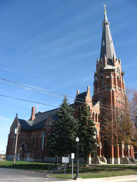
Photo: Nyttend, public domain · Wikimedia Commons
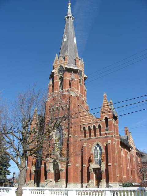
Photo: Nyttend, public domain · Wikimedia Commons
Local history sources: en.wikipedia.org · commons.wikimedia.org · hmdb.org
Historic places
1 place in Fort Loramie on the National Register of Historic Places. Press a pin or a name for its whole record.
-
St. Michael Catholic Church ComplexBuilding · Fort Loramie · listed 1979
- Address
- U.S. 705 east of U.S. 66
- Where
- Fort Loramie, Shelby County · ZIP 45845
- What it is
- Building
- Listed on the National Register
- 1979
- NRIS reference number
- 79002825
- Coordinates
- 40.35140, -84.37183
National Register file (NPS) ↗ Search Wikipedia ↗ Street map and directions ↗ On the Cracked Buckeye map
Source: National Park Service, National Register of Historic Places point file. The listing year is shown where NPS's certification date agrees with the listing's reference number. Listing recognizes significance; it does not restrict a private owner.
Water
Mostly private wells The water here
- Fort Loramie Village100% of residentsGroundwater wells (2 wells)
Hospitals, fire stations and more
Inside Fort Loramie's boundary: 1 fire or EMS station, 2 public schools, 1 library, 2 museums, 1 police station, 1 Toxics Release Inventory facility and 1 spill case. Press a pin or a name for its whole record and its source.
Fire and EMS stations (1)
-
Fort Loramie Fire DepartmentFort Loramie
- Address
- 220 North Main Street, Fort Loramie, OH 45845
- Coordinates
- 40.35279, -84.37416
USGS National Map structures (source) ↗ Street map and directions ↗
Source: USGS National Map structures (most Ohio records last updated 2019 to 2022), checked against the Columbus and Cleveland station lists. The department that answers a call is set by jurisdiction and mutual aid, not by distance.
Public schools (2)
-
Fort Loramie Elementary School5 of 5 stars · Fort Loramie
- Address
- 35 Elm St, Fort Loramie, OH 45845
- School district
- Fort Loramie Local School District
- Kind (NCES)
- Regular School
- Students, 2023-24
- 390
- Teachers (full-time equivalent)
- 28.1
- Report card, 2025-26
- 5 of 5 stars
- Performance index
- 101.7%
- Ohio building IRN
- 012633
- NCES school ID
- 390497803692
NCES school record ↗ Ohio School Report Card ↗ Street map and directions ↗
-
Fort Loramie Junior-Senior High School4.5 of 5 stars · Fort Loramie
- Address
- 600 East Park St, Fort Loramie, OH 45845
- School district
- Fort Loramie Local School District
- Kind (NCES)
- Regular School
- Students, 2023-24
- 348
- Teachers (full-time equivalent)
- 18.9
- Report card, 2025-26
- 4.5 of 5 stars
- Performance index
- 95.4%
- Four-year graduation rate
- 100%
- Ohio building IRN
- 012641
- NCES school ID
- 390497803693
NCES school record ↗ Ohio School Report Card ↗ Street map and directions ↗
Source: NCES EDGE public school locations 2024-25 and Common Core of Data 2023-24 (type, students, teachers); Ohio School Report Cards 2025-26 (Department of Education and Workforce), matched by name within the district.
Public libraries (1)
-
A.J. Wise-Fort Loramie BranchBranch · Fort Loramie
- Address
- 300 E Park St, Fort Loramie, OH 45845
- What it is
- Branch
- Library system
- Shelby County Libraries - Amos Memorial
- Open
- 1,248 hours a year, 52 weeks
- Building
- 2,800 sq ft
- System's visits, FY2024
- 174,720
- System's loans, FY2024
- 201,964
- People the system serves
- 48,230
- Phone
- (937) 295-3155
IMLS Public Libraries Survey (source) ↗ Street map and directions ↗
Source: IMLS Public Libraries Survey FY2024 (outlets and their systems). Any Ohio resident can get a free card at any Ohio public library.
Museums, historical societies, gardens and zoos (2)
-
Fort Loramie Historical AssociationHistorical society · Fort Loramie
- What it is
- Historical society
- City
- Fort Loramie
- Coordinates
- 40.35149, -84.37418
Search Wikipedia ↗ IMLS Museum Data Files (source) ↗ Street map and directions ↗
The museum list is IMLS's 2018 file; a museum may have closed or moved since.
-
Wilderness Trail MuseumMuseum · Fort Loramie
- What it is
- Museum
- City
- Fort Loramie
- Coordinates
- 40.34475, -84.37540
Search Wikipedia ↗ IMLS Museum Data Files (source) ↗ Street map and directions ↗
The museum list is IMLS's 2018 file; a museum may have closed or moved since.
Source: IMLS Museum Data Files, 2018.
Police stations (1)
-
Fort Loramie Police DepartmentFort Loramie
- Address
- 14 Elm Street, Fort Loramie, OH 45845
- Coordinates
- 40.35095, -84.37351
USGS National Map structures (source) ↗ Street map and directions ↗
Source: USGS National Map structures, police stations, corrected and completed by hand (September 2026). The department that answers a call is set by jurisdiction, not by distance.
Facilities reporting toxic releases (1)
-
Tooling TechnologyToxics Release Inventory · Fort Loramie
- Address
- 100 Enterprise Dr., Fort Loramie, OH 45845
- County
- Shelby County
- Status
- Reports to the Toxics Release Inventory (active)
- EPA program ID
- 45845TLNGT100EN
- EPA registry ID
- 110000395723
EPA facility record ↗ EPA Facility Registry Service (source) ↗ Street map and directions ↗
Source: EPA Facility Registry Service, Toxics Release Inventory reporters. Reporting a release is required of large users of listed chemicals; it is not by itself a violation.
Spills reported since 2021 (1)
-
Fuel Diesel / Diesel Fuel (Vehicle On Or Off Road)2023-07-17 · Mclean Twp
- Reported
- 2023-07-17
- What spilled
- Fuel Diesel / Diesel Fuel (Vehicle On Or Off Road)
- Largest amount reported
- 1,000 gallons
- Where
- Mclean Twp, Shelby County
- Ohio EPA district office
- SWDO
- Ohio EPA case number
- 2307EPA0001197
Ohio EPA spill reports (source) ↗ Street map and directions ↗
Source: Ohio EPA emergency response spill reports, 2021 to September 2026, one point per case where Ohio EPA placed it. A report is what the caller or responder recorded; amounts are often blank or estimated.
Its ZIP codes
Each ZIP code that touches Fort Loramie, with the share of its residents who live here and the same headline figures as the ZIP page.
| ZIP | Share | Water | Radon | Home value | Schools | Flood |
|---|---|---|---|---|---|---|
| 45845 Fort Loramie | 48% | Mostly private wells | 4.1 pCi/L average radon | Median year built 1977 | Fort Loramie Local · 5 stars overall | 7.7% of residents in the 1% floodplain |
Local government
Who holds office in Fort Loramie, how its elections and ballot issues came out, and the state auditor's record.
Ballot issues
| Date | Issue | For | Against | Result |
|---|---|---|---|---|
| 2022-11-08 | Issue: Village of Fort Loramie | 451 | 107 | Passed (80.82% for) |
Elections for office
| Date | Office | Candidates and votes |
|---|---|---|
| 2023-11-07 | Member of Council | Chris Boeke 511, 43.68%; Matt Hoying 659, 56.32% |
| 2023-11-07 | Mayor | Randal J. Ahlers 709, 100.0% |
| 2019-11-05 | Member of Council (unofficial count) | Matthew Hoying 412, 100.0% |
| 2019-11-05 | Mayor (unofficial count) | Randal J. Ahlers 412, 100.0% |
Winners in bold. Results from the county board of elections' official canvass unless marked.
Auditor of State record
- No fiscal caution, watch or emergency on the Auditor of State's lists.
- Agreed Upon Procedures, 2023 to 2024, released 2025-08-07
The county
Shelby County: 11 ZIP codes, 21 cities, villages and townships, 45,735 people.
Nearby places
Rain and snow
How much has actually fallen on Fort Loramie, day by day, from 1893 to now. Daily totals, not averages.
- rain, last 30 days
- 0.89 in
- 2026-09-30 to 2026-10-29
- rain so far in 2026
- 42.8 in
- 8.3 in above normal for the date
- snow so far in 2026
- 19.8 in
- a normal year brings 22.0 in
- a normal year
- 40.6 in
- average of 30 years, 1991-2020
| Month | Rain (in) | Snow (in) | Days counted |
|---|---|---|---|
| October 2026 | 0.89 | — | 29 |
| September 2026 | 5.20 | — | 30 |
| August 2026 | 11.85 | — | 31 |
| July 2026 | 4.52 | — | 31 |
| June 2026 | 4.62 | — | 30 |
| May 2026 | 5.46 | — | 31 |
| April 2026 | 2.99 | — | 30 |
| March 2026 | 4.89 | 1.1 | 31 |
| February 2026 | 0.91 | 5.0 | 28 |
| January 2026 | 1.47 | 13.7 | 31 |
| December 2025 | 1.71 | 8.9 | 31 |
| November 2025 | 1.63 | 4.5 | 30 |
| Wettest year | 2011 — 55.3 in |
|---|---|
| Driest year | 1934 — 24.1 in |
| Snowiest year | 2014 — 50.5 in |
| Wettest day on record | 29 June 1980 — 3.83 in |
| Heaviest snowfall in a day | 26 November 1950 — 18.16 in |
| Deepest snow on the ground | 27 November 1950 — 20.14 in |
Estimated, not measured. No rain gauge has ever stood inside Fort Loramie, so every figure here is worked out from the gauges around it - the nearest ones weighted most. Treat them as close estimates rather than readings.
48,463 days of records, 1893-01-01 to 2026-10-29. Source: NOAA NCEI GHCN-Daily, 3,240 gauges in and around Ohio. A day is "gauged" when a gauge standing inside the boundary reported it, and the value is the mean of those gauges. Otherwise it is interpolated by inverse distance from every gauge reporting within 50 miles. Nothing is carried forward, back-filled or smoothed. Against NOAA nClimDiv county monthly precipitation over 136,848 complete county-months (checked 2026-10-31): correlation 0.9515, median absolute difference 0.217 in a month. Built 2026-10-31 from the Cracked Buckeye precipitation archive. Snow is the softer number — snowfall is measured by hand with a ruler, no agency publishes a gridded county snowfall series, and blowing snow defeats every observer.
Environmental permits and filings
What Ohio EPA has on file for Fort Loramie: permits, inspections, violations, cleanups and the state loans behind sewer and water work. Every line links to the agency's own document.
- facilities and sites on file
- 6
- those placed on the map inside Fort Loramie
| Program | Facilities and sites |
|---|---|
| Wastewater and stormwater discharge | 3 |
| Hazardous waste | 1 |
| Public drinking water | 1 |
| Sewer and water-line construction | 1 |
| Date | Facility or site | What |
|---|---|---|
| FORT LORAMIE VILLAGE OF PWS | Public drinking water plan | |
| FORT LORAMIE VILLAGE OF PWS | Public drinking water compliance letter | |
| RAPID ESTATES PHASE 2 | Sewer and water-line construction permit | |
| RAPID ESTATES PHASE 2 | Sewer and water-line construction permit | |
| FORT LORAMIE VILLAGE OF PWS | Public drinking water plan | |
| RAPID ESTATES PHASE 2 | Sewer and water-line construction permit | |
| FORT LORAMIE VILLAGE OF PWS | Public drinking water report | |
| FORT LORAMIE ATHLETIC COMPLEX BUILDING | Wastewater and stormwater discharge inspection | |
| FORT LORAMIE VILLAGE OF PWS | Public drinking water plan | |
| FORT LORAMIE VILLAGE OF PWS | Public drinking water inspection | |
| FORT LORAMIE ATHLETIC COMPLEX BUILDING | Wastewater and stormwater discharge permit | |
| FORT LORAMIE VILLAGE OF PWS | Public drinking water violation resolved | |
| FORT LORAMIE VILLAGE OF PWS | Public drinking water notice of violation | |
| FORT LORAMIE VILLAGE OF PWS | Public drinking water compliance letter | |
| FORT LORAMIE VILLAGE OF PWS | Public drinking water compliance letter | |
| FORT LORAMIE VILLAGE OF PWS | Public drinking water notice of violation | |
| FORT LORAMIE VILLAGE OF PWS | Public drinking water report | |
| ELM STREET IMPROVEMENTS | Wastewater and stormwater discharge permit | |
| FORT LORAMIE VILLAGE OF PWS | Public drinking water plan | |
| FORT LORAMIE VILLAGE OF PWS | Public drinking water compliance letter | |
| GREENBACK ROAD RECONSTRUCTION | Wastewater and stormwater discharge permit | |
| FORT LORAMIE VILLAGE OF PWS | Public drinking water compliance letter | |
| FORT LORAMIE VILLAGE OF PWS | Public drinking water plan | |
| FORT LORAMIE VILLAGE OF PWS | Public drinking water plan | |
| FORT LORAMIE VILLAGE OF PWS | Public drinking water plan |
Source: Ohio EPA eDocument portal (edocpub.epa.ohio.gov), indexed 2026-10-14. Facilities are placed on the map from Ohio EPA's own map layers, EPA's Facility Registry, coordinates written in the filings, or a geocoded street address. A permit filed under a private person's name (most are household septic systems) is counted but never named, placed or linked; licenses for individual workers and open-burning notices are left out entirely.
Quick answers
What county is Fort Loramie, Ohio in?
Fort Loramie is a village in Shelby County, Ohio, with 1,582 residents.
When was Fort Loramie, Ohio founded?
Fort Loramie was settled 1769 (Loramie's trading post, near but not on the later village site); laid out 1837. Founders on record: Jonathan Counts (1837 survey); the earlier trading post and fort were established by Pierre-Louis de Lorimier and, after 1794, the U.S. Army under Gen. Anthony Wayne. Source
How did Fort Loramie, Ohio get its name?
The village is named for Pierre-Louis de Lorimier (anglicized Peter Loramie), a French-Canadian fur trader who built a trading post near the site in 1769. Source
What ZIP code is Fort Loramie, Ohio?
Most of Fort Loramie is in ZIP code 45845.
Where does Fort Loramie, Ohio get its water?
The main water source for Fort Loramie (Fort Loramie Village): Mostly private wells.
Cite this page
Cite this page as:
Cracked Buckeye, "Fort Loramie, Shelby County", https://crackedbuckeye.com/place/fort-loramie/, built 2026-10-31, accessed [date].
How to cite · Report a correction · Built 2026-10-31
