East Liverpool
City · Columbiana County · 9,951 residents · 1.5% municipal income tax
Local events in East Liverpool
Nothing is posted for East Liverpool itself yet; here is what is on within 20 miles. All local events in East Liverpool
Know a calendar we should watch? Send the link
Checked October 20; the events page is refreshed daily.
Lakes near East Liverpool
The history under the water: the valley before, the dam, the stories. All Ohio lakes
How East Liverpool began
East Liverpool began in 1798 as Irish immigrant Thomas Fawcett's claim on the Ohio River at the county's southeastern tip, was platted as St. Clair in 1802, renamed Liverpool in 1816 for the English port city, and incorporated as East Liverpool in 1834. English potter James Bennett's arrival in 1839 launched an industry that made the city, at its early-20th-century peak, home to roughly 85 pottery firms producing about two-thirds of the nation's ceramics between 1880 and 1950, earning it the nicknames 'Pottery Capital of the World' and 'Crockery City.' The city's eastern edge also holds the Point of Beginning of the U.S. Public Land Survey, where the Seven Ranges survey started in 1785. East Liverpool's population peaked above 26,000 in 1970 before the pottery industry's decline; it is a smaller river city today, still built around the historic downtown its pottery wealth financed.
Settled 1798, platted 1802 (as St. Clair), incorporated 1834 (as East Liverpool), by Thomas Fawcett.
Where the name comes from
First platted as St. Clair in 1802, the town became known as Fawcettstown for founder Thomas Fawcett before being renamed Liverpool in 1816 after the English port city, whose clay-working and riverfront character it was thought to resemble. It was incorporated in 1834 as East Liverpool to distinguish it from another Liverpool Township in Medina County.
Before the town
Wikipedia's summary of East Liverpool states that Mingo, Lenape (Delaware) and Wyandot people inhabited the area until displacement following the 1794 Battle of Fallen Timbers, but no source we reviewed names a specific village, camp or burial site within the present city limits. The city's single most important Native-history connection is indirect: East Liverpool's eastern edge holds the Point of Beginning of the U.S. Public Land Survey, the spot on the Ohio-Pennsylvania line where Thomas Hutchins, Geographer of the United States, began the Seven Ranges survey on September 30, 1785, made possible only because the Treaty of Fort McIntosh that same January had ceded the region's Native claims to the United States. George Washington also surveyed and camped in the area in October 1770, decades before the treaty cessions, on a journey down the Ohio recorded in his own diaries.
Nations recorded here: Mingo (Seneca-Cayuga), Lenape (Delaware), Wyandot.
- Point of Beginning of the U.S. Public Land Survey (other) — East end of East Liverpool, on the Ohio-Pennsylvania line, Harvey Avenue (OH-39), Survey begun September 30, 1785 (kent.edu)
Timeline
- — George Washington surveys and camps in the area later occupied by East Liverpool during a journey down the Ohio River.
- — Thomas Hutchins sets the Point of Beginning of the U.S. Public Land Survey at the site that becomes East Liverpool's eastern edge.
- — Thomas Fawcett settles the riverfront land that becomes East Liverpool.
- — The site is platted as St. Clair.
- — The town is renamed Liverpool for the English port city.
- — The town incorporates as East Liverpool.
- — English potter James Bennett arrives and sets up a small kiln using local clay, launching the city's pottery industry.
- — Brothers Shakespeare and Homer Laughlin found Laughlin Brothers Pottery on the Ohio River in East Liverpool, the company that becomes Homer Laughlin China.
- — East Liverpool's roughly 85 pottery firms produce about two-thirds of all pottery made in the United States during this period.
- — Bank robber Charles 'Pretty Boy' Floyd is shot and killed by federal agents and local police near East Liverpool.
- — The Beginning Point of the U.S. Public Land Survey is designated a National Historic Landmark.
- — East Liverpool's population peaks at more than 26,000.
Stories
How a kiln became a crockery capital
When English potter James Bennett arrived in 1839, East Liverpool was still a modest river town of a few hundred people, but its clay beds and its position on the Ohio River -- for cheap coal, cheap shipping and easy access to eastern markets -- made it an obvious place to build a pottery. Bennett's small operation drew other English and American potters after him, and by the century's turn the city held dozens of competing firms, from Homer Laughlin's works, founded in 1871 by brothers Shakespeare and Homer Laughlin, to Knowles, Taylor & Knowles, whose Lotus Ware porcelain won international attention at the 1893 World's Columbian Exposition. At the industry's peak, between 1880 and 1950, roughly 85 East Liverpool firms turned out something like two-thirds of all the pottery made in the United States, and postcards proudly advertised individual East Liverpool factories as 'the largest pottery in the world.' The nicknames 'Pottery Capital of the World' and 'Crockery City' were not local boosterism so much as simple description.
The point every western survey starts from
At the far eastern edge of East Liverpool, on the state line with Pennsylvania, sits an 1881 monument marking a spot with an outsized claim on American geography: the Point of Beginning of the U.S. Public Land Survey. On September 30, 1785, Thomas Hutchins, the first Geographer of the United States, drove a stake there to start the Geographer's Line, the reference point for surveying the Seven Ranges under the new Land Ordinance of 1785 -- the first tract of the rectangular township-and-range grid that would eventually be extended across most of the country outside the original thirteen colonies. The stake itself is long gone and its exact spot now lies under the Ohio River, but the monument that replaced it was designated a National Historic Landmark in 1966, a small riverside marker in an industrial city claiming to be the literal starting point of how most of the American West was mapped.
Photographs
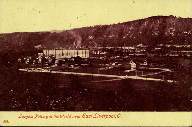
Photo: Miami University Libraries Digital Collections (Bowden Postcard Collection), no known copyright restrictions · Wikimedia Commons
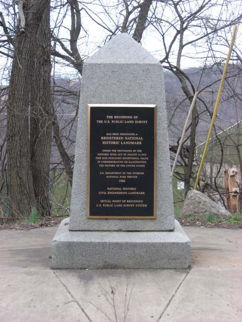
Photo: Nyttend (Wikimedia Commons), public domain · Wikimedia Commons
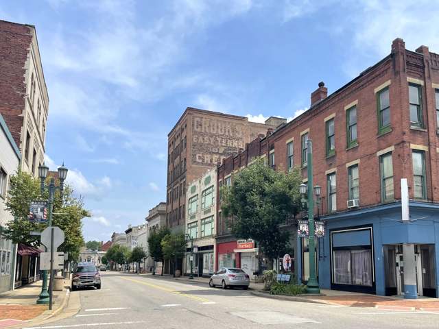
Photo: 636Buster (Wikimedia Commons), CC BY-SA 4.0 · Wikimedia Commons
Local history sources: en.wikipedia.org · en.wikipedia.org · kent.edu · en.wikipedia.org · en.wikipedia.org · commons.wikimedia.org · commons.wikimedia.org · commons.wikimedia.org
Historic places
17 places in East Liverpool on the National Register of Historic Places, 1 of them National Historic Landmark. Press a pin or a name for its whole record.
-
Beginning Point of the U.S. Public Land Survey LandmarkSite · East Liverpool · listed 1966
- Address
- On the OH/PA Border, E of East Liverpool
- Where
- East Liverpool, Columbiana County · ZIP 43920
- What it is
- Site
- Listed on the National Register
- 1966
- National Historic Landmark
- Yes
- NRIS reference number
- 66000606
- Coordinates
- 40.64246, -80.51917
National Register file (NPS) ↗ Search Wikipedia ↗ Street map and directions ↗ On the Cracked Buckeye map
-
Carnegie Public LibraryBuilding · East Liverpool · listed 1980
- Address
- 219 E. 4th St.
- Where
- East Liverpool, Columbiana County · ZIP 43920
- What it is
- Building
- Listed on the National Register
- 1980
- NRIS reference number
- 80002963
- Coordinates
- 40.61782, -80.57775
National Register file (NPS) ↗ Search Wikipedia ↗ Street map and directions ↗ On the Cracked Buckeye map
-
Cawood, Richard L., ResidenceBuilding · East Liverpool · listed 1988
- Address
- 2600 St. Clair Ave.
- Where
- East Liverpool, Columbiana County · ZIP 43920
- What it is
- Building
- Listed on the National Register
- 1988
- NRIS reference number
- 87002502
- Coordinates
- 40.64397, -80.57285
National Register file (NPS) ↗ Search Wikipedia ↗ Street map and directions ↗ On the Cracked Buckeye map
-
City HallBuilding · East Liverpool · listed 1985
- Address
- Sixth St.
- Where
- East Liverpool, Columbiana County · ZIP 43920
- What it is
- Building
- Listed on the National Register
- 1985
- NRIS reference number
- 85003511
- Coordinates
- 40.62017, -80.58057
National Register file (NPS) ↗ Search Wikipedia ↗ Street map and directions ↗ On the Cracked Buckeye map
-
East Liverpool Post OfficeBuilding · East Liverpool · listed 1976
- Address
- 5th and Broadway Sts.
- Where
- East Liverpool, Columbiana County · ZIP 43920
- What it is
- Building
- Listed on the National Register
- 1976
- NRIS reference number
- 76001384
- Coordinates
- 40.61827, -80.57703
National Register file (NPS) ↗ Search Wikipedia ↗ Street map and directions ↗ On the Cracked Buckeye map
-
East Liverpool PotteryBuilding · East Liverpool · listed 1971
- Address
- SE corner of 2nd and Market Sts.
- Where
- East Liverpool, Columbiana County · ZIP 43920
- What it is
- Building
- Listed on the National Register
- 1971
- NRIS reference number
- 71000636
- Coordinates
- 40.61657, -80.58083
National Register file (NPS) ↗ Search Wikipedia ↗ Street map and directions ↗ On the Cracked Buckeye map
-
Elks ClubBuilding · East Liverpool · listed 1985
- Address
- 139 W. Fifth St.
- Where
- East Liverpool, Columbiana County · ZIP 43920
- What it is
- Building
- Listed on the National Register
- 1985
- NRIS reference number
- 85003512
- Coordinates
- 40.61981, -80.58152
National Register file (NPS) ↗ Search Wikipedia ↗ Street map and directions ↗ On the Cracked Buckeye map
-
Godwin--Knowles HouseHistoric district · East Liverpool · listed 1985
- Address
- 422 Broadway
- Where
- East Liverpool, Columbiana County · ZIP 43920
- What it is
- Historic district
- Listed on the National Register
- 1985
- NRIS reference number
- 85003515
- Coordinates
- 40.61764, -80.57704
National Register file (NPS) ↗ Search Wikipedia ↗ Street map and directions ↗ On the Cracked Buckeye map
-
Ikirt HouseBuilding · East Liverpool · listed 1980
- Address
- 200 6th St.
- Where
- East Liverpool, Columbiana County · ZIP 43920
- What it is
- Building
- Listed on the National Register
- 1980
- NRIS reference number
- 80002964
- Coordinates
- 40.62072, -80.58151
National Register file (NPS) ↗ Search Wikipedia ↗ Street map and directions ↗ On the Cracked Buckeye map
-
Laughlin, Homer, HouseBuilding · East Liverpool · listed 1985
- Address
- 414 Broadway
- Where
- East Liverpool, Columbiana County · ZIP 43920
- What it is
- Building
- Listed on the National Register
- 1985
- NRIS reference number
- 85003513
- Coordinates
- 40.61746, -80.57704
National Register file (NPS) ↗ Search Wikipedia ↗ Street map and directions ↗ On the Cracked Buckeye map
-
Odd Fellows TempleBuilding · East Liverpool · listed 1985
- Address
- 120 W. Sixth St.
- Where
- East Liverpool, Columbiana County · ZIP 43920
- What it is
- Building
- Listed on the National Register
- 1985
- NRIS reference number
- 85003514
- Coordinates
- 40.62107, -80.58033
National Register file (NPS) ↗ Search Wikipedia ↗ Street map and directions ↗ On the Cracked Buckeye map
-
Patterson, Mary A., MemorialBuilding · East Liverpool · listed 1985
- Address
- E. Fourth St.
- Where
- East Liverpool, Columbiana County · ZIP 43920
- What it is
- Building
- Listed on the National Register
- 1985
- NRIS reference number
- 85003516
- Coordinates
- 40.61764, -80.57822
National Register file (NPS) ↗ Search Wikipedia ↗ Street map and directions ↗ On the Cracked Buckeye map
-
Potters National BankBuilding · East Liverpool · listed 1985
- Address
- Broadway and Fourth St.
- Where
- East Liverpool, Columbiana County · ZIP 43920
- What it is
- Building
- Listed on the National Register
- 1985
- NRIS reference number
- 85003518
- Coordinates
- 40.61701, -80.57752
National Register file (NPS) ↗ Search Wikipedia ↗ Street map and directions ↗ On the Cracked Buckeye map
-
Potters Savings and LoanBuilding · East Liverpool · listed 1985
- Address
- Washington and Broadway
- Where
- East Liverpool, Columbiana County · ZIP 43920
- What it is
- Building
- Listed on the National Register
- 1985
- NRIS reference number
- 85003517
- Coordinates
- 40.61908, -80.57798
National Register file (NPS) ↗ Search Wikipedia ↗ Street map and directions ↗ On the Cracked Buckeye map
-
Thompson, Cassius Clark, HouseBuilding · East Liverpool · listed 1971
- Address
- 305 Walnut St.
- Where
- East Liverpool, Columbiana County · ZIP 43920
- What it is
- Building
- Listed on the National Register
- 1971
- NRIS reference number
- 71000637
- Coordinates
- 40.61655, -80.57586
National Register file (NPS) ↗ Search Wikipedia ↗ Street map and directions ↗ On the Cracked Buckeye map
-
Travelers HotelBuilding · East Liverpool · listed 1986
- Address
- 115 E. Fourth St.
- Where
- East Liverpool, Columbiana County · ZIP 43920
- What it is
- Building
- Listed on the National Register
- 1986
- NRIS reference number
- 86001718
- Coordinates
- 40.61819, -80.57987
National Register file (NPS) ↗ Search Wikipedia ↗ Street map and directions ↗ On the Cracked Buckeye map
-
YMCABuilding · East Liverpool · listed 1985
- Address
- Washington and Fourth St.
- Where
- East Liverpool, Columbiana County · ZIP 43920
- What it is
- Building
- Listed on the National Register
- 1985
- NRIS reference number
- 85003509
- Coordinates
- 40.61782, -80.57893
National Register file (NPS) ↗ Search Wikipedia ↗ Street map and directions ↗ On the Cracked Buckeye map
Source: National Park Service, National Register of Historic Places point file. The listing year is shown where NPS's certification date agrees with the listing's reference number. Listing recognizes significance; it does not restrict a private owner.
Water
Ohio River The water here
- East Liverpool City100% of residentsOhio River
Hospitals, fire stations and more
Inside East Liverpool's boundary: 1 hospital, 1 dialysis center, 2 nursing homes, 2 fire and EMS stations, 1 college, 6 public schools, 1 poor-rated bridge, 1 library, 3 museums, 1 police station, 1 public charging site, 1 Superfund site, 4 Toxics Release Inventory facilities and 11 spill cases. Press a pin or a name for its whole record and its source.
Hospitals (1)
-
East Liverpool City HospitalGeneral hospital · East Liverpool
- What it is
- General hospital
- Address
- 425 West Fifth Street, East Liverpool, OH 43920
- County
- Columbiana County
- Beds
- 130
- Helipad
- Yes
- Ownership
- Non-profit
- Medicare overall rating
- 3 of 5 stars
- Emergency department (Medicare)
- Yes
- Phone
- (330) 385-7200
- Medicare ID
- 360096
Medicare Care Compare ↗ Where HIFLD got this record ↗ HIFLD hospitals (source) ↗ Street map and directions ↗
Source: HIFLD hospitals inventory via FEMA (closed hospitals it still lists left out, hospitals opened since added), with Medicare Care Compare ratings matched by name and address.
Dialysis centers (1)
-
Dci - East LiverpoolDialysis · East Liverpool
- Address
- 325 West 6Th Street, East Liverpool, OH 43920
- Dialysis stations
- 22
- Medicare star rating
- 3 of 5 stars
- Services
- in-center hemodialysis, peritoneal dialysis
- Ownership
- nonprofit
- Chain
- Dialysis Clinic, Inc.
- Medicare certified since
- 1989-11-08
- Phone
- (330) 382-0835
- Medicare ID
- 362516
Medicare Care Compare ↗ CMS dialysis facility list (source) ↗ Street map and directions ↗
Source: CMS dialysis facility list, September 2026, geocoded with the Census Bureau batch geocoder (an address it could not place sits at its ZIP center).
Nursing homes (2)
-
Orchards of East Liverpool, The5 of 5 stars · East Liverpool
- Address
- 709 Armstrong Lane, East Liverpool, OH 43920
- Certified beds
- 50
- Residents on an average day
- 43
- Medicare overall rating
- 5 of 5 stars
- Health inspections
- 4 of 5 stars
- Staffing
- 3 of 5 stars
- Quality measures
- 5 of 5 stars
- Penalties since 2023
- none
- Ownership
- For profit - Limited Liability company
- Chain
- THE ORCHARDS
- Takes
- Medicare and Medicaid
- Phone
- (330) 382-0101
- Medicare ID
- 366309
Medicare Care Compare ↗ CMS nursing home data (source) ↗ Street map and directions ↗
-
Valley Oaks Care Center3 of 5 stars · East Liverpool
- Address
- 500 Selfridge Street, East Liverpool, OH 43920
- Certified beds
- 67
- Residents on an average day
- 44
- Medicare overall rating
- 3 of 5 stars
- Health inspections
- 3 of 5 stars
- Staffing
- 1 of 5 stars
- Quality measures
- 5 of 5 stars
- Penalties since 2023
- none
- Ownership
- For profit - Limited Liability company
- Takes
- Medicare and Medicaid
- Phone
- (330) 385-5001
- Medicare ID
- 366306
Medicare Care Compare ↗ CMS nursing home data (source) ↗ Street map and directions ↗
Source: CMS Care Compare nursing home provider and penalties files; Medicare star ratings run 1 to 5.
Fire and EMS stations (2)
-
East Liverpool Fire Department Station 1East Liverpool
- Address
- 626 Saint Clair Avenue, East Liverpool, OH 43920
- Coordinates
- 40.62071, -80.57843
USGS National Map structures (source) ↗ Street map and directions ↗
-
East Liverpool Fire Department Station 3East Liverpool
- Address
- 1901 Saint Clair Avenue, East Liverpool, OH 43920
- Coordinates
- 40.63518, -80.57382
USGS National Map structures (source) ↗ Street map and directions ↗
Source: USGS National Map structures (most Ohio records last updated 2019 to 2022), checked against the Columbus and Cleveland station lists. The department that answers a call is set by jurisdiction and mutual aid, not by distance.
Colleges (1)
-
Kent State University at East LiverpoolRegional campus of a public university · East Liverpool
- What it is
- Regional campus of a public university
- City
- East Liverpool
- Students, 2023-24 (12-month count)
- 2,036
- Tuition and fees, in state
- $7,272
- Tuition and fees, out of state
- $16,744
- Graduation rate
- 3% of bachelor's students, within six years (a class of 34)
- IPEDS unit ID
- 203456
College Navigator (NCES) ↗ IPEDS data (source) ↗ Street map and directions ↗
Source: NCES IPEDS 2024 directory, 2023-24 enrollment and tuition, graduation rates for the 2017 (four-year) and 2020 (two-year) entering classes.
Public schools (6)
-
Buckeye On-Line School for SuccessEast Liverpool
- Address
- 119 E Fifth St, East Liverpool, OH 43920
- Kind (NCES)
- Regular School
- Students, 2023-24
- 521
- Teachers (full-time equivalent)
- 41
- NCES school ID
- 390053005240
-
East Liverpool High School2.5 of 5 stars · East Liverpool
- Address
- 100 Maine Blvd, East Liverpool, OH 43920
- School district
- East Liverpool City School District
- Kind (NCES)
- Regular School
- Students, 2023-24
- 569
- Teachers (full-time equivalent)
- 48
- Report card, 2025-26
- 2.5 of 5 stars
- Performance index
- 66.2%
- Four-year graduation rate
- 85.7%
- Ohio building IRN
- 009084
- NCES school ID
- 390439100870
NCES school record ↗ Ohio School Report Card ↗ Street map and directions ↗
-
East Liverpool Junior High3 of 5 stars · East Liverpool
- Address
- 100 Maine Blvd, East Liverpool, OH 43920
- School district
- East Liverpool City School District
- Kind (NCES)
- Regular School
- Students, 2023-24
- 308
- Teachers (full-time equivalent)
- 19
- Report card, 2025-26
- 3 of 5 stars
- Performance index
- 60.6%
- Ohio building IRN
- 040733
- NCES school ID
- 390439100872
NCES school record ↗ Ohio School Report Card ↗ Street map and directions ↗
-
North Elementary School3 of 5 stars · East Liverpool
- Address
- 90 Maine Blvd, East Liverpool, OH 43920
- School district
- East Liverpool City School District
- Kind (NCES)
- Regular School
- Students, 2023-24
- 384
- Teachers (full-time equivalent)
- 26.5
- Report card, 2025-26
- 3 of 5 stars
- Performance index
- 68.3%
- Ohio building IRN
- 027433
- NCES school ID
- 390439100874
NCES school record ↗ Ohio School Report Card ↗ Street map and directions ↗
-
Preschool at Westgate Middle SchoolEast Liverpool
- Address
- 810 W 8th St, East Liverpool, OH 43920
- Kind (NCES)
- Regular School
- Students, 2023-24
- 60
- Teachers (full-time equivalent)
- 3
- NCES school ID
- 390439106038
-
Westgate Middle School3.5 of 5 stars · East Liverpool
- Address
- 810 W 8th St, East Liverpool, OH 43920
- School district
- East Liverpool City School District
- Kind (NCES)
- Regular School
- Students, 2023-24
- 293
- Teachers (full-time equivalent)
- 23
- Report card, 2025-26
- 3.5 of 5 stars
- Performance index
- 59.6%
- Ohio building IRN
- 040717
- NCES school ID
- 390439100875
NCES school record ↗ Ohio School Report Card ↗ Street map and directions ↗
Source: NCES EDGE public school locations 2024-25 and Common Core of Data 2023-24 (type, students, teachers); Ohio School Report Cards 2025-26 (Department of Education and Workforce), matched by name within the district.
Bridges rated poor (1)
-
Ninth St over Usr-30Poor · built 1968
- Condition
- Poor: a deck, superstructure, substructure or culvert rated 4 or below on the 0 to 9 scale
- What it is
- Bridge
- Built
- 1968
- Length
- 75 ft
- Owner
- State
- Vehicles a day
- 1,000
- Coordinates
- 40.62466, -80.58480
National Bridge Inventory (source) ↗ Street map and directions ↗
Source: FHWA National Bridge Inventory 2025. "Poor" means one major part rated 4 or below on the 0 to 9 scale; it calls for repair, not closing, unless the state posts or closes the bridge.
Public libraries (1)
-
Carnegie Public LibraryCentral library · East Liverpool
- Address
- 219 E. Fourth St., East Liverpool, OH 43920
- What it is
- Central library
- Library system
- Carnegie Public Library
- Open
- 2,000 hours a year, 52 weeks
- Building
- 20,288 sq ft
- System's visits, FY2024
- 15,600
- System's loans, FY2024
- 52,862
- People the system serves
- 9,997
- Phone
- (330) 385-2048
IMLS Public Libraries Survey (source) ↗ Street map and directions ↗
Source: IMLS Public Libraries Survey FY2024 (outlets and their systems). Any Ohio resident can get a free card at any Ohio public library.
Museums, historical societies, gardens and zoos (3)
-
East Liverpool Historical SocietyHistorical society · East Liverpool
- What it is
- Historical society
- City
- East Liverpool
- Coordinates
- 40.64533, -80.57971
Search Wikipedia ↗ IMLS Museum Data Files (source) ↗ Street map and directions ↗
The museum list is IMLS's 2018 file; a museum may have closed or moved since.
-
Lou Holtz Hall Of FameMuseum · East Liverpool
- What it is
- Museum
- City
- East Liverpool
- Coordinates
- 40.61891, -80.57897
Search Wikipedia ↗ IMLS Museum Data Files (source) ↗ Street map and directions ↗
The museum list is IMLS's 2018 file; a museum may have closed or moved since.
-
Museum Of CeramicsHistory museum · East Liverpool
- What it is
- History museum
- City
- East Liverpool
- Coordinates
- 40.61847, -80.57696
Search Wikipedia ↗ IMLS Museum Data Files (source) ↗ Street map and directions ↗
The museum list is IMLS's 2018 file; a museum may have closed or moved since.
Source: IMLS Museum Data Files, 2018.
Police stations (1)
-
East Liverpool Police DepartmentEast Liverpool
- Address
- 126 West 6th Street, East Liverpool, OH 43920
- Coordinates
- 40.62027, -80.58050
USGS National Map structures (source) ↗ Street map and directions ↗
Source: USGS National Map structures, police stations, corrected and completed by hand (September 2026). The department that answers a call is set by jurisdiction, not by distance.
Public EV charging (1)
-
PEAR TREE_ELO 433 BROADWAY 12 Level 2 · East Liverpool
- Address
- 433 Broadway St, East Liverpool, OH 43920
- Ports
- 2 Level 2
- Plugs
- J1772
- Network
- ChargePoint Network
- Hours
- 24 hours daily
- Phone
- 888-758-4389
Station Locator (NREL) ↗ Alternative Fuels Data Center (source) ↗ Street map and directions ↗
Source: NREL Alternative Fuels Data Center station list (May 2026), public and open stations, the posts at one address counted as one site.
Superfund sites (1)
-
Zirconium Drum IncidentSuperfund program · East Liverpool
- Address
- 1250 Saint George Street, East Liverpool, OH 43920
- County
- Columbiana County
- Status
- Superfund program site, not on the National Priorities List
- EPA program ID
- OHN000510751
- EPA registry ID
- 110045521538
EPA facility record ↗ EPA Facility Registry Service (source) ↗ Street map and directions ↗
Source: EPA Facility Registry Service, Superfund (SEMS) and National Priorities List sites. Many program sites were assessed and needed no cleanup.
Facilities reporting toxic releases (4)
-
Ferro Corp - Porcelain PlantToxics Release Inventory · East Liverpool
- Address
- 1230 Railroad St., East Liverpool, OH 43920
- County
- Columbiana County
- Status
- Reports to the Toxics Release Inventory (active)
- EPA program ID
- 43920FRRCR1230R
- EPA registry ID
- 110002109986
EPA facility record ↗ EPA Facility Registry Service (source) ↗ Street map and directions ↗
-
Heritage Thermal ServicesToxics Release Inventory · East Liverpool
- Address
- 1250 Saint George St, East Liverpool, OH 43920
- County
- Columbiana County
- Status
- Reports to the Toxics Release Inventory (active)
- EPA program ID
- 43920VNRLL1250S
- EPA registry ID
- 110027242320
EPA facility record ↗ EPA Facility Registry Service (source) ↗ Street map and directions ↗
-
Mason Color Works IncToxics Release Inventory · East Liverpool
- Address
- 250 E 2Nd St, East Liverpool, OH 43920
- County
- Columbiana County County
- Status
- Reports to the Toxics Release Inventory (open)
- EPA program ID
- 43920MSNCL250EA
- EPA registry ID
- 110000384842
EPA facility record ↗ EPA Facility Registry Service (source) ↗ Street map and directions ↗
-
Wallover Oil Co IncToxics Release Inventory · East Liverpool
- Address
- 450 Mulberry St, East Liverpool, OH 43920
- County
- Columbiana County
- Status
- Reports to the Toxics Release Inventory (active)
- EPA program ID
- 43920WLLVR401VI
- EPA registry ID
- 110000384860
EPA facility record ↗ EPA Facility Registry Service (source) ↗ Street map and directions ↗
Source: EPA Facility Registry Service, Toxics Release Inventory reporters. Reporting a release is required of large users of listed chemicals; it is not by itself a violation.
Spills reported since 2021 (11)
-
Oil Hydraulic Fluid(S)2025-11-13 · Liverpool Twp
- Reported
- 2025-11-13
- What spilled
- Oil Hydraulic Fluid(S)
- Where
- Liverpool Twp, Columbiana County
- Ohio EPA district office
- NEDO
- Ohio EPA case number
- 2511EPA0001859
Ohio EPA spill reports (source) ↗ Street map and directions ↗
-
Oil Motor / Lube Oil / Vehicle2025-09-13 · East Liverpool
- Reported
- 2025-09-13
- What spilled
- Oil Motor / Lube Oil / Vehicle; Fuel Ethanol / E85 / Ethyl / Gasohol (Denatured); Fuel Diesel / Diesel Fuel (Vehicle On Or Off Road)
- Where
- East Liverpool, Columbiana County
- Ohio EPA district office
- NEDO
- Ohio EPA case number
- 2509EPA0001548
Ohio EPA spill reports (source) ↗ Street map and directions ↗
-
Fuel Diesel / Diesel Fuel (Vehicle On Or Off Road)2025-07-12 · East Liverpool
- Reported
- 2025-07-12
- What spilled
- Fuel Diesel / Diesel Fuel (Vehicle On Or Off Road)
- Largest amount reported
- 4 gallons
- Where
- East Liverpool, Columbiana County
- Ohio EPA district office
- NEDO
- Ohio EPA case number
- 2507EPA0001159
Ohio EPA spill reports (source) ↗ Street map and directions ↗
-
Waste Water2025-06-28 · East Liverpool
- Reported
- 2025-06-28
- What spilled
- Waste Water
- Where
- East Liverpool, Columbiana County
- Ohio EPA district office
- NEDO
- Ohio EPA case number
- 2506EPA0001078
Ohio EPA spill reports (source) ↗ Street map and directions ↗
-
Material Unknown Reached water2025-06-05 · East Liverpool
- Reported
- 2025-06-05
- What spilled
- Material Unknown
- Reached a waterway
- 99 - Unnamed
- Where
- East Liverpool, Columbiana County
- Ohio EPA district office
- NEDO
- Ohio EPA case number
- 2506EPA0000914
Ohio EPA spill reports (source) ↗ Street map and directions ↗
-
Sewage Human Reached water2024-09-03 · East Liverpool
- Reported
- 2024-09-03
- What spilled
- Sewage Human
- Reached a waterway
- 15 - Carpenter Run
- Where
- East Liverpool, Columbiana County
- Ohio EPA district office
- NEDO
- Ohio EPA case number
- 2409EPA0001510
Ohio EPA spill reports (source) ↗ Street map and directions ↗
-
Reported spill Reached water2023-09-22 · East Liverpool
- Reported
- 2023-09-22
- Reached a waterway
- 99 - Unnamed
- Where
- East Liverpool, Columbiana County
- Ohio EPA district office
- NEDO
- Ohio EPA case number
- 2309EPA0001657
Ohio EPA spill reports (source) ↗ Street map and directions ↗
-
Sewage Human Reached water2021-07-02 · East Liverpool
- Reported
- 2021-07-02
- What spilled
- Sewage Human
- Reached a waterway
- 15 - Carpenter Run
- Where
- East Liverpool, Columbiana County
- Ohio EPA district office
- NEDO
- Ohio EPA case number
- 2107EPA0000983
Ohio EPA spill reports (source) ↗ Street map and directions ↗
-
Sewage Human Reached water2021-05-10 · East Liverpool
- Reported
- 2021-05-10
- What spilled
- Sewage Human
- Reached a waterway
- 99 - Unnamed
- Where
- East Liverpool, Columbiana County
- Ohio EPA district office
- NEDO
- Ohio EPA case number
- 2105EPA0000643
Ohio EPA spill reports (source) ↗ Street map and directions ↗
-
Fuel Ethanol / E85 / Ethyl / Gasohol (Denatured)2026-07-14 · East Liverpool
- Reported
- 2026-07-14
- What spilled
- Fuel Ethanol / E85 / Ethyl / Gasohol (Denatured); Benzene (C6H6)
- Where
- East Liverpool, Columbiana County
- Ohio EPA district office
- NEDO
- Ohio EPA case number
- 2607EPA0001286
Ohio EPA spill reports (source) ↗ Street map and directions ↗
-
Sewage Human2026-05-17 · East Liverpool
- Reported
- 2026-05-17
- What spilled
- Sewage Human
- Where
- East Liverpool, Columbiana County
- Ohio EPA district office
- NEDO
- Ohio EPA case number
- 2605EPA0000822
Ohio EPA spill reports (source) ↗ Street map and directions ↗
Source: Ohio EPA emergency response spill reports, 2021 to September 2026, one point per case where Ohio EPA placed it. A report is what the caller or responder recorded; amounts are often blank or estimated.
Its ZIP codes
Each ZIP code that touches East Liverpool, with the share of its residents who live here and the same headline figures as the ZIP page.
| ZIP | Share | Water | Radon | Home value | Schools | Flood |
|---|---|---|---|---|---|---|
| 43920 East Liverpool | 46% | Ohio River | 9.2 pCi/L average radon | Appraisal records without year built | East Liverpool City · 2.5 stars overall | 0.4% of residents in the 1% floodplain |
Local government
Who holds office in East Liverpool, how its elections and ballot issues came out, and the state auditor's record.
Money issues on the ballot since 2022: 2 of 3 passed.
Ballot issues
| Date | Issue | For | Against | Result |
|---|---|---|---|---|
| 2024-11-05 | Issue: City of East Liverpool Tax Levy Cemetery | 1,203 | 1,615 | Failed (42.69% for) |
| 2023-11-07 | Issue: East Liverpool City Tax Levy Fire | 1,340 | 594 | Passed (69.29% for) |
| 2022-11-08 | Issue: East Liverpool City Tax Levy Roads | 1,304 | 682 | Passed (65.66% for) |
Elections for office
| Date | Office | Candidates and votes |
|---|---|---|
| 2023-11-07 | President of Council | John A. Torma 1,487, 100.0% |
| 2023-11-07 | Member of Council, Ward 4 | Scott Barrett 320, 100.0% |
| 2023-11-07 | Member of Council, Ward 3 | Jeffrey Kreefer 469, 100.0% |
| 2023-11-07 | Member of Council, Ward 2 | C. Fred Rayl (DEM) 373, 100.0% |
| 2023-11-07 | Member of Council, Ward 1 | Tom Beagle 351, 100.0% |
| 2023-11-07 | Member of Council at Large | Brian E. Kerr 1,142, 54.05%; John T. Mercer (DEM) 906, 42.88%; Write-In: Thomas Clark 40, 1.89% |
| 2023-11-07 | Mayor | Darlene S. Kinsey (DEM) 430, 22.23%; Shawn David McKinnon 545, 28.18%; Bobby Smith 959, 49.59% |
| 2023-11-07 | Director of Law | Charles L. Payne (DEM) 1,472, 100.0% |
| 2023-11-07 | Auditor | Marilyn Bosco (DEM) 1,460, 100.0% |
| 2021-11-02 | Treasurer | Write-In: Deborah L. Fickes 134, 48.2%; Write-In: Terry Sprague 121, 43.53% |
| 2021-11-02 | President of Council | John A. Torma 590, 100.0% |
| 2021-11-02 | Member of Council, Ward 4 | Scott Barrett 113, 100.0% |
| 2021-11-02 | Member of Council, Ward 3 | Jeffrey Kreefer 167, 100.0% |
| 2021-11-02 | Member of Council, Ward 2 | C. Fred Rayl (DEM) 126, 100.0% |
| 2021-11-02 | Member of Council, Ward 1 | Tom Beagle 158, 64.23%; Raymond Perorazio 88, 35.77% |
| 2021-11-02 | Member of Council at Large | Brian E. Kerr 434, 36.41%; John T. Mercer (DEM) 381, 31.96%; Robert Nizer, Jr. (DEM) 377, 31.63% |
Winners in bold. Results from the county board of elections' official canvass unless marked.
Auditor of State record
- Fiscal emergency: declared 1982-04-08, released 1985-07-16. source
- Financial Health Indicators (the Auditor of State's 17 measures; critical / cautionary / positive): 2020 0 / 3 / 14; 2021 0 / 1 / 16; 2022 0 / 0 / 17; 2023 1 / 0 / 16; 2024 1 / 6 / 10; 2025 0 / 1 / 15.
- OP&F Examination, 2024, released 2026-05-07
- Financial Audit, 2024, released 2025-09-02
- Financial Audit, 2023, released 2024-08-06
The county
Columbiana County: 20 ZIP codes, 33 cities, villages and townships, 106,075 people.
Nearby places
Rain and snow
How much has actually fallen on East Liverpool, day by day, from 1892 to now. Daily totals, not averages.
- rain, last 30 days
- 2.39 in
- 2026-09-30 to 2026-10-29
- rain so far in 2026
- 42.5 in
- 7.5 in above normal for the date
- snow so far in 2026
- 32.3 in
- a normal year brings 22.0 in
- a normal year
- 41.2 in
- average of 30 years, 1991-2020
| Month | Rain (in) | Snow (in) | Days counted |
|---|---|---|---|
| October 2026 | 2.39 | — | 29 |
| September 2026 | 6.20 | — | 30 |
| August 2026 | 7.05 | — | 31 |
| July 2026 | 4.47 | — | 31 |
| June 2026 | 3.98 | — | 30 |
| May 2026 | 4.70 | — | 31 |
| April 2026 | 4.64 | — | 30 |
| March 2026 | 5.71 | 5.6 | 31 |
| February 2026 | 1.13 | 5.2 | 28 |
| January 2026 | 2.28 | 21.4 | 31 |
| December 2025 | 2.55 | 10.7 | 31 |
| November 2025 | 1.93 | 0.1 | 30 |
| Wettest year | 2018 — 60.6 in |
|---|---|
| Driest year | 1930 — 27.7 in |
| Snowiest year | 1960 — 57.3 in |
| Wettest day on record | 18 September 2004 — 4.58 in |
| Heaviest snowfall in a day | 20 April 1901 — 17.01 in |
| Deepest snow on the ground | 29 November 1950 — 23.19 in |
Estimated, not measured. No rain gauge has ever stood inside East Liverpool, so every figure here is worked out from the gauges around it - the nearest ones weighted most. Treat them as close estimates rather than readings.
48,976 days of records, 1892-09-01 to 2026-10-29. Source: NOAA NCEI GHCN-Daily, 3,240 gauges in and around Ohio. A day is "gauged" when a gauge standing inside the boundary reported it, and the value is the mean of those gauges. Otherwise it is interpolated by inverse distance from every gauge reporting within 50 miles. Nothing is carried forward, back-filled or smoothed. Against NOAA nClimDiv county monthly precipitation over 136,848 complete county-months (checked 2026-10-31): correlation 0.9515, median absolute difference 0.217 in a month. Built 2026-10-31 from the Cracked Buckeye precipitation archive. Snow is the softer number — snowfall is measured by hand with a ruler, no agency publishes a gridded county snowfall series, and blowing snow defeats every observer.
Environmental permits and filings
What Ohio EPA has on file for East Liverpool: permits, inspections, violations, cleanups and the state loans behind sewer and water work. Every line links to the agency's own document.
- facilities and sites on file
- 48
- those placed on the map inside East Liverpool
| Program | Facilities and sites |
|---|---|
| Voluntary cleanup | 10 |
| Air pollution | 9 |
| Hazardous waste | 7 |
| Wastewater and stormwater discharge | 7 |
| Contaminated-site cleanup | 4 |
| State sewer loans | 3 |
| State water loans | 3 |
| Brownfield | 1 |
| Industrial landfills | 1 |
| Public drinking water | 1 |
| Site assessment | 1 |
| Wetland and stream fill | 1 |
| Date | Facility or site | What |
|---|---|---|
| ARCWOOD ENVIRONMENTAL EAST LIVERPOOL INC | Wastewater and stormwater discharge inspection | |
| ARCWOOD ENVIRONMENTAL EAST LIVERPOOL INC | Hazardous waste permit | |
| ARCWOOD ENVIRONMENTAL EAST LIVERPOOL INC | Wastewater and stormwater discharge permit | |
| ARCWOOD ENVIRONMENTAL EAST LIVERPOOL INC | Hazardous waste permit | |
| ARCWOOD ENVIRONMENTAL EAST LIVERPOOL INC | Hazardous waste report | |
| EAST LIVERPOOL WWTP | Wastewater and stormwater discharge report | |
| DW DICKEY AND SON INC | Air pollution permit | |
| EAST LIVERPOOL WWTP | Wastewater and stormwater discharge permit | |
| EAST LIVERPOOL WTP | Wastewater and stormwater discharge monitoring results | |
| S H BELL - STATELINE TERMINAL | Air pollution inspection | |
| ARCWOOD ENVIRONMENTAL EAST LIVERPOOL INC | Hazardous waste permit | |
| ARCWOOD ENVIRONMENTAL EAST LIVERPOOL INC | Hazardous waste assessment | |
| ARCWOOD ENVIRONMENTAL EAST LIVERPOOL INC | Hazardous waste permit | |
| ARCWOOD ENVIRONMENTAL EAST LIVERPOOL INC | Air pollution notice of violation | |
| ARCWOOD ENVIRONMENTAL EAST LIVERPOOL INC | Hazardous waste permit | |
| EAST LIVERPOOL WWTP | Wastewater and stormwater discharge report | |
| ARCWOOD ENVIRONMENTAL EAST LIVERPOOL INC | Hazardous waste permit | |
| S H BELL - STATELINE TERMINAL | Air pollution inspection | |
| ARCWOOD ENVIRONMENTAL EAST LIVERPOOL INC | Hazardous waste report | |
| EAST LIVERPOOL CITY PWS | Public drinking water compliance letter | |
| DW DICKEY AND SON INC | Air pollution permit | |
| TRANSMONTAIGNE OPERATING CO LP - OHIO TERMINAL | Air pollution permit | |
| S H BELL - STATELINE TERMINAL | Air pollution permit | |
| ARCWOOD ENVIRONMENTAL EAST LIVERPOOL INC | Hazardous waste permit | |
| EAST LIVERPOOL CITY PWS | Public drinking water compliance letter |
Source: Ohio EPA eDocument portal (edocpub.epa.ohio.gov), indexed 2026-10-14. Facilities are placed on the map from Ohio EPA's own map layers, EPA's Facility Registry, coordinates written in the filings, or a geocoded street address. A permit filed under a private person's name (most are household septic systems) is counted but never named, placed or linked; licenses for individual workers and open-burning notices are left out entirely.
Quick answers
What county is East Liverpool, Ohio in?
East Liverpool is a city in Columbiana County, Ohio, with 9,951 residents.
When was East Liverpool, Ohio founded?
East Liverpool was settled 1798; laid out 1802 (as St. Clair); incorporated 1834 (as East Liverpool). Founders on record: Thomas Fawcett. Source
How did East Liverpool, Ohio get its name?
First platted as St. Source
What ZIP code is East Liverpool, Ohio?
Most of East Liverpool is in ZIP code 43920.
Where does East Liverpool, Ohio get its water?
The main water source for East Liverpool (East Liverpool City): Ohio River.
Cite this page
Cite this page as:
Cracked Buckeye, "East Liverpool, Columbiana County", https://crackedbuckeye.com/place/east-liverpool/, built 2026-10-31, accessed [date].
How to cite · Report a correction · Built 2026-10-31
