Local events in Dresden
14 events in the next 90 days from 4 public calendars. All local events in Dresden
Checked October 20; the events page is refreshed daily.
Lakes near Dresden
The history under the water: the valley before, the dam, the stories. All Ohio lakes
Deep dives about Dresden
Long reads built from maps, newspapers and public records. All deep dives
How Dresden began
Dresden sits on the Muskingum River at the mouth of Wakatomika Creek, on or immediately adjacent to the site of Wakatomika, a Shawnee settlement of one large town and several smaller villages established around 1756 and destroyed by Virginia militia in 1774. Jonathan Cass and Seth Adams were among the first American settlers, claiming land there in 1799; the town was laid out in 1817 and incorporated in 1835. Dresden's best-known nineteenth-century landmark was a 1,000-foot suspension bridge across the Muskingum, built in 1852 by abolitionist and bridge-builder George Willison Adams and destroyed in the Great Flood of 1913; a replacement bridge from 1914 still carries State Route 208 across the river today.
Settled 1799, platted 1817, incorporated 1835-03-08, by Jonathan Cass and Seth Adams (first settlers); Laban Lemert opened the first store when the town was laid out in 1817.
Where the name comes from
No source we found gives a documented reason for the choice of the name "Dresden" (after the German city, as with several other Ohio towns of the era); we could not confirm the reason.
Before the town
Dresden stands at or immediately beside the site of Wakatomika, a Shawnee settlement established around 1756 by Shawnees relocating from Upper Shawneetown on the Ohio River, part of a broader migration away from Virginia colonial pressure during the era of the French and Indian War. Wakatomika was not a single town but a cluster: one large town plus three or four smaller villages strung along the Muskingum River in the vicinity of, and extending upriver from, present-day Dresden; local names recorded for parts of the settlement include "Vomiting Town" and "Snakestown" (for headmen John and Thomas Snake). It lay near a number of Lenape (Delaware) towns as well. The Moravian missionary David Zeisberger preached at Wakatomika in 1773. On August 7, 1774, during Lord Dunmore's War, a Virginia militia force under Colonel Angus McDonald burned Wakatomika and four other Shawnee villages on the Muskingum. The wrongs done to the Mingo leader John Logan, whose family had been murdered earlier that year in the Yellow Creek massacre, were discussed with much rancor at Wakatomika, and war parties went out from there while Logan led retaliatory raids against Virginia settlers. After 1774 the Wakatomika name and community relocated west, re-established by 1778 on the Mad River near present Zanesfield, Ohio (Logan County) -- a different place from the Muskingum County site. Sources describe the original Wakatomika's location as "near" or "in the vicinity of" Dresden and "extending up the Muskingum River from there," rather than placing it at one precise, single point; no source we consulted gives coordinates precise enough to say whether any part of the settlement crossed into what is now Coshocton County to the north. Readers should treat "at Dresden" as approximate: Wakatomika was a multi-village settlement centered on the Dresden area and extending upriver, not necessarily coincident with the platted village itself.
Nations recorded here: Shawnee, Lenape (Delaware), Mingo.
- Wakatomika (village) — On the Muskingum River in the vicinity of, and extending upriver from, present-day Dresden, Muskingum County, c. 1756-1774 (en.wikipedia.org)
Timeline
- — Shawnees relocating from Upper Shawneetown on the Ohio River established Wakatomika, a cluster of one large town and several smaller villages, on the Muskingum River near present-day Dresden.
- — Moravian missionary David Zeisberger preached at Wakatomika.
- — Colonel Angus McDonald's Virginia militia burned Wakatomika and four other Shawnee villages on the Muskingum during Lord Dunmore's War.
- — Jonathan Cass claimed roughly 4,000 acres in the area that became Dresden; his family joined him by 1801. Seth Adams also settled the area in 1799.
- — The town of Dresden was formally laid out; Laban Lemert opened the first merchant store, in a log house.
- — The village of Dresden was incorporated.
- — George Willison Adams financed and built a 1,000-foot suspension bridge across the Muskingum River at Dresden, made from materials manufactured in Dresden and engineered by his nephew George Copeland; it cost about $30,000 and operated as a toll bridge before Adams sold it to the county commissioners.
- — The Great Flood of 1913 destroyed the 1852 suspension bridge.
- — A replacement metal-link suspension bridge was built at the crossing, on what is now State Route 208.
- — The Dresden Suspension Bridge (the 1914 replacement) was listed on the National Register of Historic Places.
Stories
The third suspension bridge in America
In 1852 George Willison Adams, a Dresden mill owner, abolitionist, and former state legislator, put up his own money to bridge the Muskingum River at Dresden after his fellow investors got cold feet. His nephew, George Copeland, engineered a 1,000-foot suspension span built from materials manufactured right in Dresden, reportedly only the third suspension bridge built in the United States. Adams ran it as a toll bridge for a time before selling it to the county commissioners for a fraction of what it cost to build. The bridge carried traffic across the river for six decades until the Great Flood of 1913, among the worst natural disasters in Ohio history, tore it down; a metal-link suspension bridge went up in its place in 1914 and still carries State Route 208 across the Muskingum at Dresden today.
A Shawnee town on the Muskingum
Decades before Jonathan Cass and Seth Adams staked their claims, the ground around Dresden held a Shawnee settlement called Wakatomika: not one village but a string of them, a large town and three or four smaller ones, strung along the Muskingum River near where Wakatomika Creek meets it. Shawnees had moved there around 1756 from Upper Shawneetown on the Ohio River, seeking distance from Virginia's colonial frontier, and settled among Lenape neighbors already living nearby. The Moravian missionary David Zeisberger preached there in 1773, a year before Lord Dunmore's War brought Virginia militia under Colonel Angus McDonald up the Muskingum; on August 7, 1774, McDonald's men burned Wakatomika and four sister villages to the ground. Survivors eventually resettled far to the west, founding a new Wakatomika by 1778 near present Zanesfield in Logan County. The creek that runs into the Muskingum at Dresden still carries the name.
Photographs
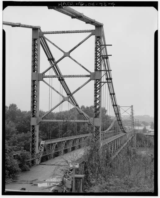
Photo: Joseph Elliott, Library of Congress Historic American Engineering Record (HAER OHIO,60-DRES,1-4), public domain · Wikimedia Commons
Local history sources: en.wikipedia.org · en.wikipedia.org · muskingumcountyhistory.org · en.wikipedia.org · commons.wikimedia.org
Historic places
2 places in Dresden on the National Register of Historic Places. Press a pin or a name for its whole record.
-
Adams, George W., HouseBuilding · Trinway · listed 1979
- Address
- S of Trinway on Bottom Rd
- Where
- Trinway, Muskingum County · ZIP 43821
- What it is
- Building
- Listed on the National Register
- 1979
- NRIS reference number
- 79001912
- Coordinates
- 40.13160, -82.01560
National Register file (NPS) ↗ Search Wikipedia ↗ Street map and directions ↗ On the Cracked Buckeye map
-
Dresden Suspension BridgeStructure · Dresden · listed 1978
- Address
- OH 208 and OH 666
- Where
- Dresden, Muskingum County · ZIP 43821
- What it is
- Structure
- Listed on the National Register
- 1978
- NRIS reference number
- 78002153
- Coordinates
- 40.12056, -82.00018
National Register file (NPS) ↗ Search Wikipedia ↗ Street map and directions ↗ On the Cracked Buckeye map
Source: National Park Service, National Register of Historic Places point file. The listing year is shown where NPS's certification date agrees with the listing's reference number. Listing recognizes significance; it does not restrict a private owner.
Water
Mostly private wells The water here
- Dresden100% of residentsGroundwater wells (3 wells)
Hospitals, fire stations and more
Inside Dresden's boundary: 1 fire or EMS station, 3 public schools, 1 library, 1 police station, 1 public charging site and 1 Toxics Release Inventory facility. Press a pin or a name for its whole record and its source.
Fire and EMS stations (1)
-
Dresden Fire DepartmentDresden
- Address
- 21 West 9th Street, Dresden, OH 43821
- Coordinates
- 40.12011, -82.01272
USGS National Map structures (source) ↗ Street map and directions ↗
Source: USGS National Map structures (most Ohio records last updated 2019 to 2022), checked against the Columbus and Cleveland station lists. The department that answers a call is set by jurisdiction and mutual aid, not by distance.
Public schools (3)
-
Dresden Elementary School4.5 of 5 stars · Dresden
- Address
- 1318 Main St, Dresden, OH 43821
- School district
- Tri-Valley Local School District
- Kind (NCES)
- Regular School
- Students, 2023-24
- 496
- Teachers (full-time equivalent)
- 19
- Report card, 2025-26
- 4.5 of 5 stars
- Performance index
- 84.9%
- Ohio building IRN
- 018069
- NCES school ID
- 390488703436
NCES school record ↗ Ohio School Report Card ↗ Street map and directions ↗
-
Tri-Valley High School4 of 5 stars · Dresden
- Address
- 46 E Muskingum Ave, Dresden, OH 43821
- School district
- Tri-Valley Local School District
- Kind (NCES)
- Regular School
- Students, 2023-24
- 731
- Teachers (full-time equivalent)
- 34
- Report card, 2025-26
- 4 of 5 stars
- Performance index
- 82.8%
- Four-year graduation rate
- 97.3%
- Ohio building IRN
- 037515
- NCES school ID
- 390488703438
NCES school record ↗ Ohio School Report Card ↗ Street map and directions ↗
-
Tri-Valley Middle School3 of 5 stars · Dresden
- Address
- 1360 Main St, Dresden, OH 43821
- School district
- Tri-Valley Local School District
- Kind (NCES)
- Regular School
- Students, 2023-24
- 483
- Teachers (full-time equivalent)
- 23
- Report card, 2025-26
- 3 of 5 stars
- Performance index
- 75.9%
- Ohio building IRN
- 067322
- NCES school ID
- 390488704376
NCES school record ↗ Ohio School Report Card ↗ Street map and directions ↗
Source: NCES EDGE public school locations 2024-25 and Common Core of Data 2023-24 (type, students, teachers); Ohio School Report Cards 2025-26 (Department of Education and Workforce), matched by name within the district.
Public libraries (1)
-
Dresden Branch LibraryBranch · Dresden
- Address
- 816 Main St., Dresden, OH 43821
- What it is
- Branch
- Library system
- Muskingum County Library System
- Open
- 2,180 hours a year, 52 weeks
- Building
- 4,500 sq ft
- System's visits, FY2024
- 214,604
- System's loans, FY2024
- 486,677
- People the system serves
- 86,410
- Phone
- (740) 754-1003
IMLS Public Libraries Survey (source) ↗ Street map and directions ↗
Source: IMLS Public Libraries Survey FY2024 (outlets and their systems). Any Ohio resident can get a free card at any Ohio public library.
Police stations (1)
-
Dresden Police DepartmentDresden
- Address
- 904 Chestnut Street, Dresden, OH 43821
- Coordinates
- 40.11994, -82.01129
USGS National Map structures (source) ↗ Street map and directions ↗
Source: USGS National Map structures, police stations, corrected and completed by hand (September 2026). The department that answers a call is set by jurisdiction, not by distance.
Public EV charging (1)
-
The Inn at Dresden, a Select Registry Property - Tesla Destination2 Level 2 · Dresden
- Address
- 209 Ames Dr, Dresden, OH 43821
- Ports
- 2 Level 2
- Plugs
- J1772, Tesla (NACS)
- Network
- Tesla Destination
- Phone
- 877-798-3752
Station Locator (NREL) ↗ Alternative Fuels Data Center (source) ↗ Street map and directions ↗
Source: NREL Alternative Fuels Data Center station list (May 2026), public and open stations, the posts at one address counted as one site.
Facilities reporting toxic releases (1)
-
Longaberger Basket CoToxics Release Inventory · Dresden
- Address
- 1360 Main St, Dresden, OH 43821
- County
- Muskingum County
- Status
- Reports to the Toxics Release Inventory (active)
- EPA program ID
- 43821LNGBR1360S
- EPA registry ID
- 110001622619
EPA facility record ↗ EPA Facility Registry Service (source) ↗ Street map and directions ↗
Source: EPA Facility Registry Service, Toxics Release Inventory reporters. Reporting a release is required of large users of listed chemicals; it is not by itself a violation.
Its ZIP codes
Each ZIP code that touches Dresden, with the share of its residents who live here and the same headline figures as the ZIP page.
| ZIP | Share | Water | Radon | Home value | Schools | Flood |
|---|---|---|---|---|---|---|
| 43821 Dresden | 36% | Mostly private wells | 4.0 pCi/L average radon | Appraisal records without year built | Tri-Valley Local · 4 stars overall | 9.5% of residents in the 1% floodplain |
Local government
Who holds office in Dresden and how its elections and ballot issues came out.
Who holds office
| Office | Name | Party | Term ends | Contact |
|---|---|---|---|---|
| Mayor | Gregory A. Morrison | 2023 | PO Box 535 Dresden 43821 | |
| Clerk-Treasurer-Vacant | Michael E. King | 2023 | 37 W Fifth Street Dresden 43821 | |
| Council | Michael Sterling | 2023 | 20 8th Street Dresden 43821 | |
| Council | Teddy Lee Crozier Sr | 2021 | 33 W Sixth Street Dresden 43821 | |
| Council | Rhonda U. Holdren | 2021 | 31 W Fifth Street Dresden 43821 | |
| Council | Margaret Marie Lacy | 2021 | 704 High Street Dresden 43821 | |
| Council | Larry Lee King | 2021 | 44 W Dave Longaberger Ave Dresden 43821 | |
| Council | Richard Warren Parsons | 2021 | 244 Ames Drive Dresden 43821 | |
| Board of Public Affairs | Michael Eugene King | 2023 | 37 W Fifth Street Dresden 43821 | |
| Board of Public Affairs | Francis Holzschuler | 2021 | 32 W Ninth Street Dresden 43821 |
Roster as of 2019: official county or city website.
Money issues on the ballot since 2017: 2 of 3 passed; of those asking for new or higher taxes, 1 of 1.
Ballot issues
| Date | Issue | For | Against | Result |
|---|---|---|---|---|
| 2021-11-02 | Issue: Dresden Bond Streets 3.2 mills 10 yr (3.2 mills) | 158 | 114 | Passed (58.09% for) |
| 2018-11-06 | Issue: Dresden Streets New 2 mil Continious (2.0 mills) | 0 | 0 | Failed |
| 2017-11-07 | Issue: Dresden Current Expenses, 3.8 mills 5 yrs Renewal (3.8 mills, renewal) | 190 | 136 | Passed (58.28% for) |
Elections for office
| Date | Office | Candidates and votes |
|---|---|---|
| 2021-11-02 | Council Member | Rhonda U. Holdren 176, 36.51%; Pam Bice 160, 33.2%; Brandon R. Bronkar 146, 30.29% |
| 2019-11-05 | Mayor | Gregory A. Morrison 252, 61.17%; David Alan Mathew 160, 38.83% |
| 2019-11-05 | Council Member | Ted L. Crozier, Sr 278, 57.56%; Michael Sterling 205, 42.44% |
Winners in bold. Results from the county board of elections' official canvass unless marked. The county's results on file run through 2021-11-02; later elections are not loaded yet.
On the November 3, 2026 ballot
Statewide question: State Issue 3: Voter ID
Races, candidates and every question for an address: your ballot. County offices and judges are on your county board's sample ballot.
The county
Muskingum County: 17 ZIP codes, 38 cities, villages and townships with pages here, 87,014 people (Census Bureau estimate, July 2025).
Nearby places
Rain and snow
How much has actually fallen on Dresden, day by day, from 1887 to now. Daily totals, not averages.
- rain, last 30 days
- 1.17 in
- 2026-10-01 to 2026-10-30
- rain so far in 2026
- 45.5 in
- 9.6 in above normal for the date
- snow so far in 2026
- 22.6 in
- a normal year brings 22.2 in
- a normal year
- 42.1 in
- average of 30 years, 1991-2020
| Month | Rain (in) | Snow (in) | Days counted |
|---|---|---|---|
| October 2026 | 1.17 | — | 30 |
| September 2026 | 6.10 | — | 30 |
| August 2026 | 10.06 | — | 31 |
| July 2026 | 4.12 | — | 31 |
| June 2026 | 4.17 | — | 30 |
| May 2026 | 6.75 | — | 31 |
| April 2026 | 2.55 | — | 30 |
| March 2026 | 6.95 | 2.4 | 31 |
| February 2026 | 1.69 | 3.3 | 28 |
| January 2026 | 1.91 | 16.9 | 31 |
| December 2025 | 2.66 | 11.2 | 31 |
| November 2025 | 2.45 | 0.3 | 30 |
| Wettest year (estimated) | 2018 — 56.2 in |
|---|---|
| Driest year (estimated) | 1930 — 22.9 in |
| Wettest day (estimated) | 14 July 1913 — 4.73 in |
| Heaviest snowfall in a day (estimated) | 20 April 1901 — 13.38 in |
| Deepest snow on the ground (estimated) | 15 January 1968 — 19.87 in |
Estimated, not measured. No rain gauge has ever stood inside Dresden, so every figure here is worked out from the gauges around it - the nearest ones weighted most. Treat them as close estimates rather than readings.
49,734 days of records, 1887-08-01 to 2026-10-30. Source: NOAA NCEI GHCN-Daily, 3,240 gauges in and around Ohio. A day is "gauged" when a gauge standing inside the boundary reported it, and the value is the mean of those gauges. Otherwise it is interpolated by inverse distance from every gauge reporting within 50 miles. Nothing is carried forward, back-filled or smoothed. Against NOAA nClimDiv county monthly precipitation over 136,848 complete county-months (checked 2026-11-02): correlation 0.9515, median absolute difference 0.217 in a month. Built 2026-11-02 from the Cracked Buckeye precipitation archive. Snow is the softer number — snowfall is measured by hand with a ruler, no agency publishes a gridded county snowfall series, and blowing snow defeats every observer.
Environmental permits and filings
What Ohio EPA has on file for Dresden: permits, inspections, violations, cleanups and the state loans behind sewer and water work. Every line links to the agency's own document.
- facilities and sites on file
- 7
- those placed on the map inside Dresden
| Program | Facilities and sites |
|---|---|
| Hazardous waste | 2 |
| Public drinking water | 1 |
| State sewer loans | 1 |
| State water loans | 1 |
| Wastewater and stormwater discharge | 1 |
| Wetland and stream fill | 1 |
| Date | Facility or site | What |
|---|---|---|
| DRESDEN PWS | Public drinking water compliance letter | |
| DRESDEN PWS | Public drinking water compliance letter | |
| DRESDEN PWS | Public drinking water compliance letter | |
| DRESDEN PWS | Public drinking water warning letter | |
| DRESDEN PWS | Public drinking water report | |
| DRESDEN PWS | Public drinking water violation resolved | |
| DRESDEN VILLAGE | Public drinking water notice of violation | |
| DRESDEN PWS | Public drinking water plan | |
| DRESDEN PWS | Public drinking water inspection | |
| DRESDEN PWS | Public drinking water compliance letter | |
| DRESDEN PWS | Public drinking water compliance letter | |
| DRESDEN PWS | Public drinking water report | |
| DRESDEN PWS | Public drinking water compliance letter | |
| DRESDEN PWS | Public drinking water notice of violation | |
| DRESDEN PWS | Public drinking water inspection | |
| DRESDEN PWS | Public drinking water compliance letter | |
| DRESDEN PWS | Public drinking water violation resolved | |
| DRESDEN PWS | Public drinking water compliance letter | |
| DRESDEN PWS | Public drinking water inspection | |
| DRESDEN PWS | Public drinking water report | |
| DRESDEN PWS | Public drinking water withdrawn | |
| DRESDEN PWS | Public drinking water compliance letter | |
| DRESDEN PWS | Public drinking water notice of violation | |
| DRESDEN PWS | Public drinking water permit | |
| TRI-VALLEY LOCAL SCHOOLS DISTRICT OFFICE | Wastewater and stormwater discharge permit |
Source: Ohio EPA eDocument portal (edocpub.epa.ohio.gov), indexed 2026-10-14. Facilities are placed on the map from Ohio EPA's own map layers, EPA's Facility Registry, coordinates written in the filings, or a geocoded street address. A permit filed under a private person's name (most are household septic systems) is counted but never named, placed or linked; licenses for individual workers and open-burning notices are left out entirely.
Quick answers
What county is Dresden, Ohio in?
Dresden is a village in Muskingum County, Ohio, with 1,655 residents.
When was Dresden, Ohio founded?
Dresden was settled 1799; laid out 1817; incorporated 1835-03-08. Founders on record: Jonathan Cass and Seth Adams (first settlers); Laban Lemert opened the first store when the town was laid out in 1817. Source
What ZIP code is Dresden, Ohio?
Most of Dresden is in ZIP code 43821.
Where does Dresden, Ohio get its water?
The main water source for Dresden (Dresden): Mostly private wells.
Cite this page
Cite this page as:
Cracked Buckeye, "Dresden, Muskingum County", https://crackedbuckeye.com/place/dresden/, built 2026-11-02, accessed [date].
How to cite · Report a correction · Built 2026-11-02