Local events in Doylestown
20 events in the next 90 days from 3 public calendars. All local events in Doylestown
Checked October 20; the events page is refreshed daily.
How Doylestown began
Doylestown was laid out in 1827 by William Doyle on a hilltop in northern Wayne County where two Native American trails crossed, five years after Thomas Frederick, a Lancaster, Pennsylvania settler, had become the area's first Euro-American homesteader in 1813. What began as a farming hamlet became a coal town: commercial mining opened in 1840 in a nearby valley that took on the name Rogues' Hollow, and by the time the last local mine closed in 1940 at least 102 mines had operated in the area. The coal boom carried the village past 1,000 residents by 1896 and supported a machinery industry, the Excelsior Mowers and Droppers works founded in 1861. Coal gave way to manufacturing and, in the twenty-first century, to a role as a bedroom community for Akron and Cleveland; at roughly 1,250 feet, Doylestown sits at the highest point in Wayne County.
Settled 1813 (Thomas Frederick, first settler), platted 1827, by William Doyle.
Where the name comes from
Named for William Doyle, who purchased 50 acres and laid out the village's 40 lots in 1827.
Before the town
William Doyle chose the site for his 1827 town not arbitrarily but at the crossing of two Native American trails on a hilltop, meaning Doylestown's location was inherited directly from a pre-existing indigenous travel route; neither trail is named in the sources checked. No mound, village or treaty event specific to the site was found. Wayne County's wider Delaware, Wyandot and Shawnee record includes the Peace Trail/Killbuck Path, Great Trail and War Trail, recorded crossing the county generally; any of them may be related to the trails at Doylestown, though no source consulted makes that connection explicit.
- Trail crossing at Doylestown townsite (trail) — hilltop at present Doylestown, pre-1827 (en.wikipedia.org)
Timeline
- — Thomas Frederick, from Lancaster, Pennsylvania, becomes the first settler to establish a homestead at the future site of Doylestown.
- — William Doyle purchases 50 acres and lays out a 40-lot village at the crossing of two Native American trails; the survey is recorded by Charles Christmas on December 25.
- — Brick production begins, followed by grain and wool mills, a tannery and a distillery.
- — Commercial coal mining begins in the valley southeast of the village, first called Nibrara, then Pleasant Valley, and eventually Rogues' Hollow.
- — The Excelsior Mowers and Droppers factory is established, manufacturing self-raking mowing machines to serve the growing local population.
- — Doylestown's population passes 1,000 during the coal boom.
- — A factory fire damages the local mower industry as coal's viability is already declining.
- — A new school building is constructed incorporating fire-safety features adopted in response to the 1908 Collinwood school fire.
- — The last coal mine in the Rogues' Hollow area closes; at least 102 mines had operated there since 1840.
- — Midwest Container Co. (later Mid-West Poly Pak) is founded and continues operating as a plastics manufacturer today.
Stories
Rogues' Hollow: a hundred mines in a hundred years
Southeast of Doylestown lies a valley that carried two gentler names, Nibrara and then Pleasant Valley, before commercial coal mining began there in 1840 and the place earned the name it kept: Rogues' Hollow. Over the century that followed, at least 102 separate mines operated in the hollow and the surrounding hills, drawing miners and their families into a landscape that had been quiet farmland a generation before. The coal built Doylestown as much as it built the hollow itself, pushing the village's population past 1,000 by 1896 and supporting secondary industries in town, including the Excelsior Mowers and Droppers factory, founded in 1861 to build self-raking mowing machines. The boom could not last forever: coal's local viability was already fading by 1900, a factory fire in 1901 damaged the mower works, and by 1940 the last mine in Rogues' Hollow shut down for good, leaving behind a name that still marks the valley on maps long after the coal cars stopped running.
A school built from a Cleveland tragedy
On March 4, 1908, a fire at the Lakeview School in Collinwood, near Cleveland, killed more than 170 children and adults and became one of the deadliest school fires in American history, prompting school districts across Ohio and the country to rethink how their buildings could trap people inside a fire. When Doylestown built a new school in 1909, barely a year after Collinwood, it incorporated fire-safety features adopted directly in response to that disaster — a small, concrete example of how a catastrophe in one Ohio community could reshape construction decisions in another, unrelated one more than a hundred miles away.
Photographs
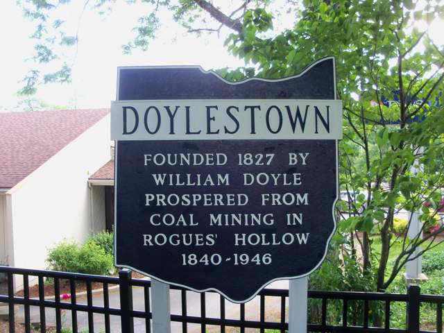
Photo: Roseohioresident, CC BY-SA 4.0 · Wikimedia Commons
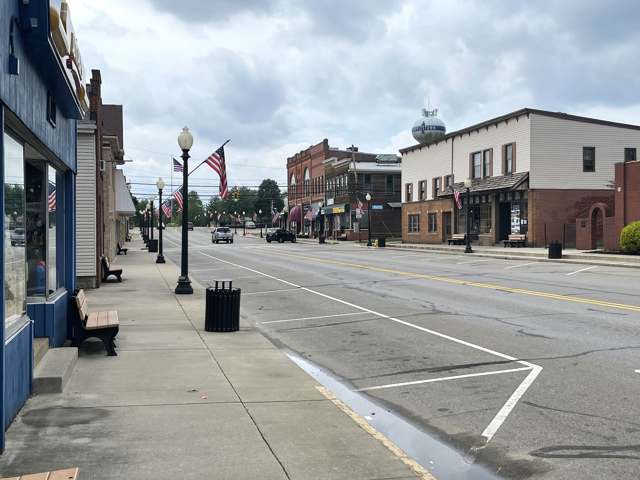
Photo: Will Maupin (SpokaneWilly), CC BY-SA 4.0 · Wikimedia Commons
Local history sources: en.wikipedia.org · commons.wikimedia.org · commons.wikimedia.org
Water
Mostly private wells The water here
- Doylestown Village91% of residentsGroundwater wells (2 wells)
- Westview MHP7% of residentsGroundwater wells (2 wells)
- Sundial Mobile Home Park2% of residentsGroundwater wells (3 wells)
Hospitals, fire stations and more
Inside Doylestown's boundary: 1 nursing home, 1 fire or EMS station, 4 public schools, 1 private school, 1 library, 1 museum, 1 police station, 1 Superfund site and 3 spill cases. Press a pin or a name for its whole record and its source.
Nursing homes (1)
-
Doylestown Health Care Center3 of 5 stars · Doylestown
- Address
- 95 Black Drive, Doylestown, OH 44230
- Certified beds
- 78
- Residents on an average day
- 53
- Medicare overall rating
- 3 of 5 stars
- Health inspections
- 2 of 5 stars
- Staffing
- 3 of 5 stars
- Quality measures
- 5 of 5 stars
- Penalties since 2023
- none
- Ownership
- For profit - Corporation
- Chain
- WINDSOR HOUSE, INC.
- Takes
- Medicare and Medicaid
- Phone
- (330) 658-2061
- Medicare ID
- 365695
Medicare Care Compare ↗ CMS nursing home data (source) ↗ Street map and directions ↗
Source: CMS Care Compare nursing home provider and penalties files; Medicare star ratings run 1 to 5.
Fire and EMS stations (1)
-
Chippewa Township Fire Department Station 1Doylestown
- Address
- 464 Gates Street, Doylestown, OH 44230
- Coordinates
- 40.97729, -81.69704
USGS National Map structures (source) ↗ Street map and directions ↗
Source: USGS National Map structures (most Ohio records last updated 2019 to 2022), checked against the Columbus and Cleveland station lists. The department that answers a call is set by jurisdiction and mutual aid, not by distance.
Public schools (4)
-
Chippewa Intermediate School4 of 5 stars · Doylestown
- Address
- 100 Valley View Rd, Doylestown, OH 44230
- School district
- Chippewa Local School District
- Kind (NCES)
- Regular School
- Students, 2023-24
- 342
- Report card, 2025-26
- 4 of 5 stars
- Performance index
- 91.7%
- Ohio building IRN
- 008748
- NCES school ID
- 390505303977
NCES school record ↗ Ohio School Report Card ↗ Street map and directions ↗
-
Chippewa Jr./Sr. High School4.5 of 5 stars · Doylestown
- Address
- 466 South Portage, Doylestown, OH 44230
- School district
- Chippewa Local School District
- Kind (NCES)
- Regular School
- Students, 2023-24
- 588
- Report card, 2025-26
- 4.5 of 5 stars
- Performance index
- 88.1%
- Four-year graduation rate
- 99.1%
- Ohio building IRN
- 006312
- NCES school ID
- 390505303976
NCES school record ↗ Ohio School Report Card ↗ Street map and directions ↗
-
Chippewa Virtual Learning AcademyDoylestown
- Address
- 466 S Portage St, Doylestown, OH 44230
- Kind (NCES)
- Regular School
- Students, 2023-24
- 37
- NCES school ID
- 390505306176
-
Hazel Harvey Elementary School3.5 of 5 stars · Doylestown
- Address
- 165 Brooklyn Ave, Doylestown, OH 44230
- School district
- Chippewa Local School District
- Kind (NCES)
- Regular School
- Students, 2023-24
- 318
- Report card, 2025-26
- 3.5 of 5 stars
- Ohio building IRN
- 015743
- NCES school ID
- 390505303978
NCES school record ↗ Ohio School Report Card ↗ Street map and directions ↗
Source: NCES EDGE public school locations 2024-25 and Common Core of Data 2023-24 (type, students, teachers); Ohio School Report Cards 2025-26 (Department of Education and Workforce), matched by name within the district.
Private schools (1)
-
Sts Peter & Paul SchoolPrivate, Catholic · Doylestown
- Address
- 169 W Clinton St, Doylestown, OH 44230
- Kind
- Catholic
- Students, 2023-24
- 56
- Teachers (full-time equivalent)
- 8
- Students per teacher
- 7
- Phone
- (330) 658-2804
- NCES private school ID
- 01057307
Source: NCES Private School Survey 2023-24.
Public libraries (1)
-
Doylestown BranchBranch · Doylestown
- Address
- 169 N. Portage St., Doylestown, OH 44230
- What it is
- Branch
- Library system
- Wayne County Public Library
- Open
- 2,496 hours a year, 52 weeks
- Building
- 5,200 sq ft
- System's visits, FY2024
- 367,900
- System's loans, FY2024
- 1,989,812
- People the system serves
- 105,271
- Phone
- (330) 804-4689
IMLS Public Libraries Survey (source) ↗ Street map and directions ↗
Source: IMLS Public Libraries Survey FY2024 (outlets and their systems). Any Ohio resident can get a free card at any Ohio public library.
Museums, historical societies, gardens and zoos (1)
-
Chippewa-Rogues Hollow Historical SocietyHistorical society · Doylestown
- What it is
- Historical society
- City
- Doylestown
- Coordinates
- 40.97068, -81.69050
Search Wikipedia ↗ IMLS Museum Data Files (source) ↗ Street map and directions ↗
The museum list is IMLS's 2018 file; a museum may have closed or moved since.
Source: IMLS Museum Data Files, 2018.
Police stations (1)
-
Doylestown Police DepartmentDoylestown
- Address
- 20 South Portage Street, Doylestown, OH 44230
- Coordinates
- 40.96910, -81.69809
USGS National Map structures (source) ↗ Street map and directions ↗
Source: USGS National Map structures, police stations, corrected and completed by hand (September 2026). The department that answers a call is set by jurisdiction, not by distance.
Superfund sites (1)
-
Cecil's Transmission RepairSuperfund program · Doylestown
- Address
- 209 Collier Rd, Doylestown, OH 44230
- County
- Wayne County
- Status
- Superfund program site, not on the National Priorities List
- EPA program ID
- OH0001899277
- EPA registry ID
- 110004721196
EPA facility record ↗ EPA Facility Registry Service (source) ↗ Street map and directions ↗
Source: EPA Facility Registry Service, Superfund (SEMS) and National Priorities List sites. Many program sites were assessed and needed no cleanup.
Spills reported since 2021 (3)
-
Oil Transformer Non Pcb2025-06-14 · Doylestown
- Reported
- 2025-06-14
- What spilled
- Oil Transformer Non Pcb
- Largest amount reported
- 22 gallons
- Where
- Doylestown, Wayne County
- Ohio EPA district office
- NEDO
- Ohio EPA case number
- 2506EPA0000970
Ohio EPA spill reports (source) ↗ Street map and directions ↗
-
Fuel Diesel / Diesel Fuel (Vehicle On Or Off Road)2025-01-03 · Doylestown
- Reported
- 2025-01-03
- What spilled
- Fuel Diesel / Diesel Fuel (Vehicle On Or Off Road)
- Where
- Doylestown, Wayne County
- Ohio EPA district office
- NEDO
- Ohio EPA case number
- 2501EPA0000005
Ohio EPA spill reports (source) ↗ Street map and directions ↗
-
Sewage Human2022-08-21 · Doylestown
- Reported
- 2022-08-21
- What spilled
- Sewage Human
- Where
- Doylestown, Wayne County
- Ohio EPA district office
- NEDO
- Ohio EPA case number
- 2208EPA0001284
Ohio EPA spill reports (source) ↗ Street map and directions ↗
Source: Ohio EPA emergency response spill reports, 2021 to September 2026, one point per case where Ohio EPA placed it. A report is what the caller or responder recorded; amounts are often blank or estimated.
Its ZIP codes
Each ZIP code that touches Doylestown, with the share of its residents who live here and the same headline figures as the ZIP page.
| ZIP | Share | Water | Radon | Home value | Schools | Flood |
|---|---|---|---|---|---|---|
| 44230 Chippewa Township and Doylestown | 38% | Mostly private wells | 4.9 pCi/L average radon | Median year built 1974 | Chippewa Local · 4 stars overall | 1.0% of residents in the 1% floodplain |
The county
Wayne County: 15 ZIP codes, 33 cities, villages and townships, 124,210 people.
Nearby places
Rain and snow
How much has actually fallen on Doylestown, day by day, from 1893 to now. Daily totals, not averages.
- rain, last 30 days
- 1.56 in
- 2026-10-01 to 2026-10-30
- rain so far in 2026
- 36.2 in
- 2.1 in above normal for the date
- snow so far in 2026
- 28.0 in
- a normal year brings 38.2 in
- a normal year
- 39.8 in
- average of 30 years, 1991-2020
| Month | Rain (in) | Snow (in) | Days counted |
|---|---|---|---|
| October 2026 | 1.56 | — | 30 |
| September 2026 | 4.20 | — | 30 |
| August 2026 | 4.35 | — | 31 |
| July 2026 | 4.37 | — | 31 |
| June 2026 | 3.36 | — | 30 |
| May 2026 | 4.74 | — | 31 |
| April 2026 | 6.47 | 0.1 | 30 |
| March 2026 | 4.40 | 1.8 | 31 |
| February 2026 | 0.91 | 7.6 | 28 |
| January 2026 | 1.84 | 18.5 | 31 |
| December 2025 | 2.14 | 11.1 | 31 |
| November 2025 | 1.57 | 3.2 | 30 |
| Wettest year | 2011 — 57.6 in |
|---|---|
| Driest year | 1991 — 24.1 in |
| Snowiest year | 2010 — 71.3 in |
| Wettest day on record | 5 July 1969 — 6.28 in |
| Heaviest snowfall in a day | 9 November 1913 — 15.89 in |
| Deepest snow on the ground | 10 November 1913 — 17.99 in |
Estimated, not measured. No rain gauge has ever stood inside Doylestown, so every figure here is worked out from the gauges around it - the nearest ones weighted most. Treat them as close estimates rather than readings.
48,621 days of records, 1893-01-01 to 2026-10-30. Source: NOAA NCEI GHCN-Daily, 3,240 gauges in and around Ohio. A day is "gauged" when a gauge standing inside the boundary reported it, and the value is the mean of those gauges. Otherwise it is interpolated by inverse distance from every gauge reporting within 50 miles. Nothing is carried forward, back-filled or smoothed. Against NOAA nClimDiv county monthly precipitation over 136,848 complete county-months (checked 2026-11-01): correlation 0.9515, median absolute difference 0.217 in a month. Built 2026-11-01 from the Cracked Buckeye precipitation archive. Snow is the softer number — snowfall is measured by hand with a ruler, no agency publishes a gridded county snowfall series, and blowing snow defeats every observer.
Environmental permits and filings
What Ohio EPA has on file for Doylestown: permits, inspections, violations, cleanups and the state loans behind sewer and water work. Every line links to the agency's own document.
- facilities and sites on file
- 4
- those placed on the map inside Doylestown
| Program | Facilities and sites |
|---|---|
| Air pollution | 1 |
| Hazardous waste | 1 |
| Public drinking water | 1 |
| Wastewater and stormwater discharge | 1 |
| Date | Facility or site | What |
|---|---|---|
| DOYLESTOWN VILLAGE PWS | Public drinking water notice of violation | |
| DOYLESTOWN VILLAGE PWS | Public drinking water compliance letter | |
| DOYLESTOWN VILLAGE PWS | Public drinking water notice of violation | |
| DOYLESTOWN VILLAGE PWS | Public drinking water violation resolved | |
| DOYLESTOWN VILLAGE PWS | Public drinking water inspection | |
| DOYLESTOWN VILLAGE PWS | Public drinking water report | |
| DOYLESTOWN VILLAGE PWS | Public drinking water notice of violation | |
| DOYLESTOWN VILLAGE PWS | Public drinking water notice of violation | |
| DOYLESTOWN VILLAGE PWS | Public drinking water violation resolved | |
| DOYLESTOWN VILLAGE PWS | Public drinking water notice of violation | |
| DOYLESTOWN VILLAGE PWS | Public drinking water notice of violation | |
| DOYLESTOWN VILLAGE PWS | Public drinking water letter | |
| DOYLESTOWN VILLAGE PWS | Public drinking water inspection | |
| DOYLESTOWN VILLAGE PWS | Public drinking water plan | |
| DOYLESTOWN VILLAGE PWS | Public drinking water violation resolved | |
| DOYLESTOWN VILLAGE PWS | Public drinking water notice of violation | |
| DOYLESTOWN VILLAGE PWS | Public drinking water inspection | |
| DOYLESTOWN VILLAGE PWS | Public drinking water inspection | |
| DOYLESTOWN VILLAGE PWS | Public drinking water inspection | |
| DOYLESTOWN VILLAGE PWS | Public drinking water warning letter | |
| DOYLESTOWN VILLAGE PWS | Public drinking water notice of violation | |
| DOYLESTOWN VILLAGE PWS | Public drinking water inspection | |
| DOYLESTOWN VILLAGE PWS | Public drinking water inspection | |
| DOYLESTOWN VILLAGE PWS | Public drinking water violation resolved | |
| DOYLESTOWN VILLAGE PWS | Public drinking water compliance letter |
Source: Ohio EPA eDocument portal (edocpub.epa.ohio.gov), indexed 2026-10-14. Facilities are placed on the map from Ohio EPA's own map layers, EPA's Facility Registry, coordinates written in the filings, or a geocoded street address. A permit filed under a private person's name (most are household septic systems) is counted but never named, placed or linked; licenses for individual workers and open-burning notices are left out entirely.
Quick answers
What county is Doylestown, Ohio in?
Doylestown is a village in Wayne County, Ohio, with 3,051 residents.
When was Doylestown, Ohio founded?
Doylestown was settled 1813 (Thomas Frederick, first settler); laid out 1827. Founders on record: William Doyle. Source
How did Doylestown, Ohio get its name?
Named for William Doyle, who purchased 50 acres and laid out the village's 40 lots in 1827. Source
What ZIP code is Doylestown, Ohio?
Most of Doylestown is in ZIP code 44230.
Where does Doylestown, Ohio get its water?
The main water source for Doylestown (Doylestown Village): Mostly private wells.
Cite this page
Cite this page as:
Cracked Buckeye, "Doylestown, Wayne County", https://crackedbuckeye.com/place/doylestown/, built 2026-10-31, accessed [date].
How to cite · Report a correction · Built 2026-10-31