Local events in Crooksville
4 events in the next 90 days from 2 public calendars. All local events in Crooksville
Checked October 20; the events page is refreshed daily.
How Crooksville began
Crooksville grew up on land Jacob Reed began acquiring in the 1820s under a deed signed by President James Monroe; a post office opened in 1874 under the name of Joseph Crooks after the government rejected the first choice, 'Reeds Post Office,' as a duplicate. Coal and, above all, clay drove its growth: farm-scale 'bluebird potteries' that fired only between spring and fall gave way to industrial stoneware works, and the village incorporated in 1894 at about 800 people. By 1920 the population had reached 3,311 during the pottery and coal boom, and Crooksville, paired with neighboring Roseville, became known as 'the Clay City of Perry County' and home to Hull Pottery, one of Ohio's best-known potteries.
Settled 1820s, incorporated 1894, by grew from a post office petition by Jacob Reed and Joseph Crooks.
Where the name comes from
The U.S. Post Office Department approved a post office under the name Crooksville in 1874, after Joseph Crooks and Jacob Reed's first proposal, 'Reeds Post Office,' was rejected as a duplicate of an existing Ohio office. Crooks's son later said the chosen name 'was pleasing to my father.'
Before the town
No site-specific Native American history is recorded for the village of Crooksville itself. Perry County as a whole lay in territory the 1883 county history describes as occupied by the Shawnee, Lenape (Delaware) and Wyandot, who 'roamed over the great stretch of country' between the Muskingum and Scioto rivers and camped temporarily along Sunday and Monday creeks and near the Great Swamp; the same source states the Wyandot presence in the county came after white settlement began and was peaceable.
Nations recorded here: Shawnee, Lenape (Delaware), Wyandot.
Timeline
- — Jacob Reed arrives in the area and begins acquiring land under a deed signed by President James Monroe, starting with a lumber mill and farm.
- — Railroad construction through Reed's property leads him to build a warehouse and establish Reed Station.
- — J. E. Crook, born in Muskingum County in 1825, comes to Perry County; he serves as station agent for the Cincinnati & Muskingum Valley Railroad at Crooksville for some seven years, keeps a store there for about five, and, the 1883 county history says, was instrumental in getting the post office located at Crooksville.
- — The Post Office Department approves Joseph Crooks's post-office petition under the name Crooksville, rejecting the proposed 'Reeds Post Office' as a duplicate.
- — Crooksville is established about this year two miles east of McLuney on the Cincinnati & Muskingum Valley Railroad and soon becomes a considerable coal-mining point, with several potteries making stoneware for distant markets; the 1883 county history counts about a hundred inhabitants, a railway station, post office and store.
- — Harrison Township, which includes Crooksville, McLuney and part of Roseville, has 1,562 people including its villages; coal seams No. 5 and No. 6 underlie nearly the whole township and a valuable seam of potter's clay has been worked for a long time.
- — Crooksville is formally incorporated as a village, population about 800.
- — The census counts 3,028 residents, up from 835 in 1900, as the pottery works and coal mines draw workers; the village peaks at 3,311 in 1920.
- — Population peaks at 3,311 during the pottery and coal boom, up from 835 in 1900 and 3,028 in 1910.
- — The census counts 2,890 residents, down from 3,251 in 1930; it is 2,960 in 1950 and 2,534 in 2010.
- — The census counts 2,418 residents.
Stories
The bluebird potteries
Long before Crooksville had a factory district, farmers along the ridges above the Muskingum fired small kilns of stoneware on the side, using clay dug from their own land. The work was seasonal: firing began in spring, when the bluebirds returned from their winter range, and stopped in autumn when the birds left again, giving the operations their local nickname, 'bluebird potteries.' The 1883 county history records ware being made across the district at Somerset, Rehoboth, McLuney, New Lexington, Crooksville, Roseville and Saltillo. As rail lines reached the area those scattered farm kilns consolidated into year-round factories, and by the early twentieth century Crooksville and neighboring Roseville, sharing the same clay beds and rail spurs, were turning out the stoneware and dinnerware that made the pair famous as 'Potteryland USA,' home to Hull Pottery.
A name settled by a duplicate
When Jacob Reed and Joseph Crooks petitioned Washington for a post office in 1874, they proposed calling it Reeds Post Office. The Post Office Department wrote back that the name was already taken elsewhere in Ohio and suggested Crooksville instead. Joseph Crooks's son later recalled that the substitute name suited his father fine. The episode is a small, ordinary one, but it is the only surviving account of how the village got its name, and it ties Crooksville's origin to the same kind of post-office paperwork that named dozens of small Ohio places in the mid-1800s.
A railroad station that became a pottery town
The 1883 Perry County history barely notices Crooksville. It describes McLuney, a coal village with 66 people in 1880, and says that two miles east of it, on the Cincinnati & Muskingum Valley Railroad, Crooksville 'was established about 1874' and 'soon became a considerable point for coal mining.' It had several potteries making stoneware that was sold in distant markets, a railway station, a post office and a store, and the historian remarks that it did not appear in the census as a separate village but was 'justly entitled to recognition as such,' with about a hundred inhabitants. The station agent, J. E. Crook, a Muskingum County man who had come to Perry County in 1868, was credited with getting the post office located there. Harrison Township, with its coal seams and its potter's clay, held 1,562 people in 1880, and Roseville next door sat mostly on the Muskingum County side. Incorporated in 1894 with about 800 people, Crooksville had 3,028 in 1910 and 3,311 in 1920.
Photographs
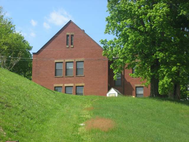
Photo: Nyttend, public domain · Wikimedia Commons
Local history sources: en.wikipedia.org · archive.org · commons.wikimedia.org · commons.wikimedia.org
Historic places
1 place in Crooksville on the National Register of Historic Places. Press a pin or a name for its whole record.
-
West SchoolBuilding · Crooksville · listed 1980
- Address
- Off OH 93
- Where
- Crooksville, Perry County · ZIP 43731
- What it is
- Building
- Listed on the National Register
- 1980
- NRIS reference number
- 80003207
- Coordinates
- 39.77095, -82.10299
National Register file (NPS) ↗ Search Wikipedia ↗ Street map and directions ↗ On the Cracked Buckeye map
Source: National Park Service, National Register of Historic Places point file. The listing year is shown where NPS's certification date agrees with the listing's reference number. Listing recognizes significance; it does not restrict a private owner.
Water
Six wells (4 MGD combined) in a sand-and-gravel aquifer in the Hocking River Buried Valley aquifer system, Dover Township, Athens County (2025 CCR). Ohio EPA's May 2012 source water assessment rates the source highly susceptible to contamination (thin clay cover, aquifer less than 20 ft deep). The water here
- Crooksville96% of residentsHocking River Buried Valley Aquifer (wells)
- Portersville East Branch Water Co.2% of residentsHocking River Buried Valley Aquifer (wells)
- Southern Perry Co-mainesville2% of residentsHocking River Buried Valley Aquifer (wells)
Hospitals, fire stations and more
Inside Crooksville's boundary: 1 fire or EMS station, 3 public schools, 1 library, 1 police station, 3 Superfund sites, 3 Toxics Release Inventory facilities and 9 spill cases. Press a pin or a name for its whole record and its source.
Fire and EMS stations (1)
-
Crooksville Fire DepartmentCrooksville
- Address
- 22 China Street, Crooksville, OH 43731
- Coordinates
- 39.77090, -82.09686
USGS National Map structures (source) ↗ Street map and directions ↗
Source: USGS National Map structures (most Ohio records last updated 2019 to 2022), checked against the Columbus and Cleveland station lists. The department that answers a call is set by jurisdiction and mutual aid, not by distance.
Public schools (3)
-
Crooksville Elementary School3 of 5 stars · Crooksville
- Address
- 12400 Tunnel Hill Rd, Crooksville, OH 43731
- School district
- Crooksville Ex Vill School District
- Kind (NCES)
- Regular School
- Students, 2023-24
- 451
- Teachers (full-time equivalent)
- 18.9
- Report card, 2025-26
- 3 of 5 stars
- Performance index
- 74.3%
- Ohio building IRN
- 118331
- NCES school ID
- 390453500313
NCES school record ↗ Ohio School Report Card ↗ Street map and directions ↗
-
Crooksville High School2.5 of 5 stars · Crooksville
- Address
- 4075 Ceramic Way, Crooksville, OH 43731
- School district
- Crooksville Ex Vill School District
- Kind (NCES)
- Regular School
- Students, 2023-24
- 306
- Teachers (full-time equivalent)
- 14.9
- Report card, 2025-26
- 2.5 of 5 stars
- Performance index
- 66.6%
- Four-year graduation rate
- 95.4%
- Ohio building IRN
- 007823
- NCES school ID
- 390453502186
NCES school record ↗ Ohio School Report Card ↗ Street map and directions ↗
-
Crooksville Middle School2 of 5 stars · Crooksville
- Address
- 12400 Tunnel Hill Rd, Crooksville, OH 43731
- School district
- Crooksville Ex Vill School District
- Kind (NCES)
- Regular School
- Students, 2023-24
- 320
- Teachers (full-time equivalent)
- 19.5
- Report card, 2025-26
- 2 of 5 stars
- Performance index
- 62.9%
- Ohio building IRN
- 007450
- NCES school ID
- 390453504221
NCES school record ↗ Ohio School Report Card ↗ Street map and directions ↗
Source: NCES EDGE public school locations 2024-25 and Common Core of Data 2023-24 (type, students, teachers); Ohio School Report Cards 2025-26 (Department of Education and Workforce), matched by name within the district.
Public libraries (1)
-
Crooksville BranchBranch · Crooksville
- Address
- 111 E. Main St., Crooksville, OH 43731
- What it is
- Branch
- Library system
- Perry County District Library
- Open
- 1,456 hours a year, 52 weeks
- Building
- 2,160 sq ft
- System's visits, FY2024
- 84,708
- System's loans, FY2024
- 194,470
- People the system serves
- 34,633
- Phone
- (740) 982-4821
IMLS Public Libraries Survey (source) ↗ Street map and directions ↗
Source: IMLS Public Libraries Survey FY2024 (outlets and their systems). Any Ohio resident can get a free card at any Ohio public library.
Police stations (1)
-
Crooksville Police DepartmentCrooksville
- Address
- 98 South Buckeye Street, Crooksville, OH 43731
- Coordinates
- 39.76873, -82.09958
USGS National Map structures (source) ↗ Street map and directions ↗
Source: USGS National Map structures, police stations, corrected and completed by hand (September 2026). The department that answers a call is set by jurisdiction, not by distance.
Superfund sites (3)
-
Former Burley & Winter PotterySuperfund program · Crooksville
- Address
- 713 Keystone Street, Crooksville, OH 43731
- County
- Perry County
- Status
- Superfund program site, not on the National Priorities List
- EPA program ID
- OHN000508882
- EPA registry ID
- 110071101962
EPA facility record ↗ EPA Facility Registry Service (source) ↗ Street map and directions ↗
-
Former Watt PotterySuperfund program · Crooksville
- Address
- 101 China Street, Crooksville, OH 43731
- County
- Perry County
- Status
- Superfund program site, not on the National Priorities List
- EPA program ID
- OHR000175851
- EPA registry ID
- 110071102070
EPA facility record ↗ EPA Facility Registry Service (source) ↗ Street map and directions ↗
-
Hull PotterySuperfund program · Crooksville
- Address
- 327 Amerine St, Crooksville, OH 43731
- County
- Perry County
- Status
- Superfund program site, not on the National Priorities List
- EPA program ID
- OHD004296430
- EPA registry ID
- 110004595643
EPA facility record ↗ EPA Facility Registry Service (source) ↗ Street map and directions ↗
Source: EPA Facility Registry Service, Superfund (SEMS) and National Priorities List sites. Many program sites were assessed and needed no cleanup.
Facilities reporting toxic releases (3)
-
Cerco I, Inc. Cesco PlantToxics Release Inventory · Crooksville
- Address
- 416 Maple Ave., Crooksville, OH 43731
- County
- Perry County
- Status
- Reports to the Toxics Release Inventory (active)
- EPA program ID
- 43731FRRCR416MA
- EPA registry ID
- 110002109959
EPA facility record ↗ EPA Facility Registry Service (source) ↗ Street map and directions ↗
-
Pcc Airfoils LlcToxics Release Inventory · Crooksville
- Address
- 700 China St., Crooksville, OH 43731
- County
- Perry County
- Status
- Reports to the Toxics Release Inventory (closed)
- EPA program ID
- 43731PCCRF700CH
- EPA registry ID
- 110000384566
EPA facility record ↗ EPA Facility Registry Service (source) ↗ Street map and directions ↗
-
Pcc Airfoils Llc - CrooksvilleToxics Release Inventory · Crooksville
- Address
- 101 China St, Crooksville, OH 43731
- County
- Perry County
- Status
- Reports to the Toxics Release Inventory (active)
- EPA program ID
- 43731PCCRF11CHI
- EPA registry ID
- 110043694295
EPA facility record ↗ EPA Facility Registry Service (source) ↗ Street map and directions ↗
Source: EPA Facility Registry Service, Toxics Release Inventory reporters. Reporting a release is required of large users of listed chemicals; it is not by itself a violation.
Spills reported since 2021 (9)
-
Other / All Other / Trade Name / Mixture / Solution Etc2025-09-26 · Crooksville
- Reported
- 2025-09-26
- What spilled
- Other / All Other / Trade Name / Mixture / Solution Etc
- Largest amount reported
- 126 gallons
- Where
- Crooksville, Perry County
- Ohio EPA district office
- SEDO
- Ohio EPA case number
- 2509EPA0001607
Ohio EPA spill reports (source) ↗ Street map and directions ↗
-
Waste Water2025-02-16 · Crooksville
- Reported
- 2025-02-16
- What spilled
- Waste Water
- Where
- Crooksville, Perry County
- Ohio EPA district office
- SEDO
- Ohio EPA case number
- 2502EPA0000211
Ohio EPA spill reports (source) ↗ Street map and directions ↗
-
Sludge (Non-Sewage)2024-08-04 · Harrison Twp
- Reported
- 2024-08-04
- What spilled
- Sludge (Non-Sewage)
- Where
- Harrison Twp, Perry County
- Ohio EPA district office
- SEDO
- Ohio EPA case number
- 2408EPA0001342
Ohio EPA spill reports (source) ↗ Street map and directions ↗
-
Waste Water2024-08-02 · Crooksville
- Reported
- 2024-08-02
- What spilled
- Waste Water
- Largest amount reported
- 500 gallons
- Where
- Crooksville, Perry County
- Ohio EPA district office
- SEDO
- Ohio EPA case number
- 2408EPA0001327
Ohio EPA spill reports (source) ↗ Street map and directions ↗
-
Sewage Sludge / Biosolids2024-07-04 · Crooksville
- Reported
- 2024-07-04
- What spilled
- Sewage Sludge / Biosolids
- Where
- Crooksville, Perry County
- Ohio EPA district office
- SEDO
- Ohio EPA case number
- 2407EPA0001125
Ohio EPA spill reports (source) ↗ Street map and directions ↗
-
Fuel Oil/ Home Heating / Heating Oil2024-04-04 · Pease Twp
- Reported
- 2024-04-04
- What spilled
- Fuel Oil/ Home Heating / Heating Oil
- Largest amount reported
- 500 gallons
- Where
- Pease Twp, Belmont County
- Ohio EPA district office
- SEDO
- Ohio EPA case number
- 2404EPA0000528
Ohio EPA spill reports (source) ↗ Street map and directions ↗
-
Oil Transformer Non Pcb2022-03-19 · Crooksville
- Reported
- 2022-03-19
- What spilled
- Oil Transformer Non Pcb
- Where
- Crooksville, Perry County
- Ohio EPA district office
- SEDO
- Ohio EPA case number
- 2203EPA0000368
Ohio EPA spill reports (source) ↗ Street map and directions ↗
-
Oil Motor / Lube Oil / Vehicle2026-08-18 · Crooksville
- Reported
- 2026-08-18
- What spilled
- Oil Motor / Lube Oil / Vehicle
- Where
- Crooksville, Perry County
- Ohio EPA district office
- SEDO
- Ohio EPA case number
- 2608EPA0001540
Ohio EPA spill reports (source) ↗ Street map and directions ↗
-
Oil Petroleum Not Otherwise Specified (Nos)2026-08-11 · Crooksville
- Reported
- 2026-08-11
- What spilled
- Oil Petroleum Not Otherwise Specified (Nos); Fuel Ethanol / E85 / Ethyl / Gasohol (Denatured)
- Where
- Crooksville, Perry County
- Ohio EPA district office
- SEDO
- Ohio EPA case number
- 2608EPA0001463
Ohio EPA spill reports (source) ↗ Street map and directions ↗
Source: Ohio EPA emergency response spill reports, 2021 to September 2026, one point per case where Ohio EPA placed it. A report is what the caller or responder recorded; amounts are often blank or estimated.
Its ZIP codes
Each ZIP code that touches Crooksville, with the share of its residents who live here and the same headline figures as the ZIP page.
Local government
Who holds office in Crooksville, how its elections and ballot issues came out, and the state auditor's record.
Auditor of State record
- No fiscal caution, watch or emergency on the Auditor of State's lists.
- Financial Audit, 2022 to 2023, released 2025-11-25
The county
Perry County: 11 ZIP codes, 26 cities, villages and townships, 38,855 people.
Nearby places
Rain and snow
How much has actually fallen on Crooksville, day by day, from 1887 to now. Daily totals, not averages.
- rain, last 30 days
- 1.52 in
- 2026-09-30 to 2026-10-29
- rain so far in 2026
- 48.3 in
- 12.0 in above normal for the date
- snow so far in 2026
- 17.2 in
- a normal year brings 16.6 in
- a normal year
- 42.6 in
- average of 30 years, 1991-2020
| Month | Rain (in) | Snow (in) | Days counted |
|---|---|---|---|
| October 2026 | 1.52 | — | 29 |
| September 2026 | 7.44 | — | 30 |
| August 2026 | 12.63 | — | 31 |
| July 2026 | 4.19 | — | 31 |
| June 2026 | 3.46 | — | 30 |
| May 2026 | 6.10 | — | 31 |
| April 2026 | 3.21 | — | 30 |
| March 2026 | 6.79 | 3.8 | 31 |
| February 2026 | 1.20 | 2.3 | 28 |
| January 2026 | 1.73 | 11.1 | 31 |
| December 2025 | 1.96 | 8.2 | 31 |
| November 2025 | 2.54 | 0.4 | 30 |
| Wettest year | 2011 — 57.6 in |
|---|---|
| Driest year | 1930 — 21.8 in |
| Snowiest year | 1917 — 54.8 in |
| Wettest day on record | 9 September 2004 — 4.68 in |
| Heaviest snowfall in a day | 14 January 1968 — 17.20 in |
| Deepest snow on the ground | 14 January 1968 — 20.97 in |
Estimated, not measured. No rain gauge has ever stood inside Crooksville, so every figure here is worked out from the gauges around it - the nearest ones weighted most. Treat them as close estimates rather than readings.
49,679 days of records, 1887-08-01 to 2026-10-29. Source: NOAA NCEI GHCN-Daily, 3,240 gauges in and around Ohio. A day is "gauged" when a gauge standing inside the boundary reported it, and the value is the mean of those gauges. Otherwise it is interpolated by inverse distance from every gauge reporting within 50 miles. Nothing is carried forward, back-filled or smoothed. Against NOAA nClimDiv county monthly precipitation over 136,848 complete county-months (checked 2026-10-31): correlation 0.9515, median absolute difference 0.217 in a month. Built 2026-10-31 from the Cracked Buckeye precipitation archive. Snow is the softer number — snowfall is measured by hand with a ruler, no agency publishes a gridded county snowfall series, and blowing snow defeats every observer.
Environmental permits and filings
What Ohio EPA has on file for Crooksville: permits, inspections, violations, cleanups and the state loans behind sewer and water work. Every line links to the agency's own document.
- facilities and sites on file
- 36
- those placed on the map inside Crooksville
| Program | Facilities and sites |
|---|---|
| Hazardous waste | 11 |
| Wastewater and stormwater discharge | 5 |
| Air pollution | 4 |
| Site assessment | 4 |
| Contaminated-site cleanup | 3 |
| Brownfield | 2 |
| State sewer loans | 2 |
| State water loans | 2 |
| Public drinking water | 1 |
| Sewer and water-line construction | 1 |
| Voluntary cleanup | 1 |
| Date | Facility or site | What |
|---|---|---|
| CHRISTY CATALYTICS LLC | Air pollution report | |
| CERCO I INC | Air pollution report | |
| CROOKSVILLE PWS | Public drinking water report | |
| CHRISTY CATALYTICS LLC | Air pollution report | |
| ASHLAND BRANDED NO 200 000 | Air pollution report | |
| CROOKSVILLE PWS | Public drinking water plan | |
| CROOKSVILLE PWS | Public drinking water inspection | |
| CROOKSVILLE PWS | Public drinking water inspection | |
| CHRISTY CATALYTICS LLC | Wastewater and stormwater discharge violation resolved | |
| PCC AIRFOILS LLC - CROOKSVILLE | Wastewater and stormwater discharge inspection | |
| CROOKSVILLE PWS | Public drinking water notice of violation | |
| CROOKSVILLE PWS | Public drinking water inspection | |
| CROOKSVILLE PWS | Public drinking water compliance letter | |
| CHRISTY CATALYTICS LLC | Wastewater and stormwater discharge notice of violation | |
| CROOKSVILLE PWS | Public drinking water inspection | |
| CROOKSVILLE PWS | Public drinking water report | |
| CROOKSVILLE PWS | Public drinking water inspection | |
| CROOKSVILLE PWS | Public drinking water report | |
| CROOKSVILLE PWS | Public drinking water inspection | |
| CROOKSVILLE PWS | Public drinking water inspection | |
| ROSEVILLE WWTP | State sewer loans | |
| ROSEVILLE WWTP | State sewer loans | |
| ROSEVILLE WWTP | State sewer loans | |
| CROOKSVILLE PWS | Public drinking water inspection | |
| CROOKSVILLE PWS | Public drinking water compliance letter |
Source: Ohio EPA eDocument portal (edocpub.epa.ohio.gov), indexed 2026-10-14. Facilities are placed on the map from Ohio EPA's own map layers, EPA's Facility Registry, coordinates written in the filings, or a geocoded street address. A permit filed under a private person's name (most are household septic systems) is counted but never named, placed or linked; licenses for individual workers and open-burning notices are left out entirely.
Quick answers
What county is Crooksville, Ohio in?
Crooksville is a village in Perry County, Ohio, with 2,418 residents.
When was Crooksville, Ohio founded?
Crooksville was settled 1820s; incorporated 1894. Founders on record: grew from a post office petition by Jacob Reed and Joseph Crooks. Source
How did Crooksville, Ohio get its name?
The U.S. Source
What ZIP code is Crooksville, Ohio?
Most of Crooksville is in ZIP code 43731.
Where does Crooksville, Ohio get its water?
The main water source for Crooksville (Crooksville): Six wells (4 MGD combined) in a sand-and-gravel aquifer in the Hocking River Buried Valley aquifer system, Dover Township, Athens County (2025 CCR). Ohio EPA's May 2012 source water assessment rates the source highly susceptible to contamination (thin clay cover, aquifer less than 20 ft deep).
Cite this page
Cite this page as:
Cracked Buckeye, "Crooksville, Perry County", https://crackedbuckeye.com/place/crooksville/, built 2026-10-31, accessed [date].
How to cite · Report a correction · Built 2026-10-31
