Water system
Crooksville
EPA ID OH6400111 · Perry County · 2,534 people served · owned by a local government
Crooksville buys its water from Burr Oak Regional Water District.
The system's record
- Aquifer
- Hocking River buried valley aquifer (sand and gravel)
- Active wells
- 6
- Serves
- 1,994 people · Athens County
- EPA ID
- OH0501311
6 wells pump ~4 MGD from a sand-and-gravel aquifer within the Hocking River buried valley system; serves Athens/Hocking/Morgan/Perry county customers.
About this area's water
Did you know
- Crooksville buys 100% of its drinking water rather than treating any itself — it's entirely dependent on the Burr Oak Regional Water District's wellfield near Athens.
- That same wellfield also supplies 17 other 'satellite' systems and roughly 36,000 other Ohioans besides Crooksville's own 2,534 residents.
- Crooksville grew up around 'bluebird pottery' kilns fired only in spring and fall (when the bluebirds were around), earning it the nickname 'The Clay City of Perry County,' and later hosted the well-known Hull Pottery…
- The village's 2025 water report had to publicly correct multiple errors from the prior year's report — including a copper action level mistakenly listed as 1,300 ppm instead of 1.3 ppm, and understated disinfection…
Source: crooksville.comen.wikipedia.org
History5
- 1874Village grew out of a post-office petition; the Post Office Department approved Joseph Crooks's request after rejecting the proposed 'Reeds Post Office' as a duplicate, naming it Crooksville instead.
- 1894Formally incorporated as a village, population about 800.
- 1920Population peaked at 3,311 (per Wikipedia's history section), having grown from 835 in 1900 to 3,028 in 1910 during the pottery and coal boom; not 1910 as previously stated. (2,534 are served by the…
- 2012Ohio EPA completed a Drinking Water Source Assessment for Burr Oak Regional Water District's wellfield, rating it highly susceptible to contamination.
- 2025The 2025 CCR disclosed and corrected multiple errors in Crooksville's 2024 CCR: copper MCLG was reported as 0 ppm (actual 1.3 ppm) and its action level as 1,300 ppm (actual 1.3 ppm); lead 90th…
Source: en.wikipedia.orgcrooksville.com
Treatment & pressure
How it is treated
Crooksville has no treatment plant of its own; it buys fully treated water from Burr Oak Regional Water District, which pumps groundwater from 6 wells (about 4 MGD) in the sand-and-gravel Hocking River Buried Valley aquifer in Athens County/Dover Township and disinfects with chlorine (TTHM/HAA5 are…
Source: crooksville.com
Water pressure
Not published; no pressure-zone or psi figures appear in the 2025 CCR or the village site.
What it costs
Not published online; the village directs residents to the Utility Billing Department (740-982-2712) for current water rates — this phone number matches the billing contact given…
Source: crooksville.com
Water quality & impurities8
| Contaminant | Level | Limit | Year |
|---|---|---|---|
| Total Trihalomethanes (TTHM) Range 44.2-71.5 ppb. Flagged as a violation in the 2025 CCR despite being under the 80 ppb numeric MCL (a… | 71.5 ppb | 80 ppb | 2025 |
| Haloacetic Acids (HAA5) Range 11.7-21 ppb; no violation. By-product of chlorination. | 21 ppb | 60 ppb | 2025 |
| Lead (90th percentile) 0 of 10 samples over the action level. | 1.0 ppb | 15 ppb action… | 2025 |
| Copper (90th percentile) 0 of 10 samples over the action level. | 0.158 ppm | 1.3 ppm action… | 2025 |
| Fluoride Range 0.77-1.24 ppm. | 1.24 ppm | 4 ppm | 2025 |
| Nitrate Well below MCL. | 0.50 ppm | 10 ppm | 2025 |
| Barium BORWD sampling result. | 0.061 ppm | 2 ppm | 2023 |
| Cyanide BORWD sampling result. | 1.0 ppb | 200 ppb | 2023 |
Source: crooksville.com
EPA compliance record
Lead at the tap: 90th-percentile result 1.4 ppb in 2025 (action level 15 ppb).
EPA health-based violations since 2015:
- 2017Total trihalomethanes (TTHM) · exceeded a maximum contaminant level · measured 0.081 MG/L (limit 0.08 MG/L) · returned to compliance
9 violations of any kind logged since 2020, 9 of them paperwork (monitoring, reporting, public notice or consumer report).
EPA compliance record · Burr Oak Regional Water District (treats the water)
Lead at the tap: 90th-percentile result 1.7 ppb in 2025 (action level 15 ppb).
EPA record: no health-based violations since 2015.
1 violation of any kind logged since 2020, 1 of them paperwork (monitoring, reporting, public notice or consumer report).
Projects & plans2
Recent and current work
- Water Systems Improvement Project
A village web page referencing this project exists but, on direct review, contains no cost, scope, or date detail — only navigation/contact boilerplate. Year…
Source: crooksville.com
Planned or needed
- Lead service line inventory · under construction
Per the 2025 CCR: 'The Village of Crooksville continues to work on the service line inventory,' viewable in person at the village office, 22 China Street…
Source: crooksville.com
Supply stress
The purchased source (Burr Oak Regional Water District's wells in the Hocking River Buried Valley aquifer) is rated by Ohio EPA (Drinking Water Source Assessment, May 2012) as highly susceptible to contamination, due to a protective clay layer under 20 ft thick, depth to water under 20 ft, and nearby potential contaminant sources (a…
Source: crooksville.com
Sewers
Sanitary
Not confirmed from sources reviewed; Crooksville's site does not publish sewer plant details in the pages checked.
Storm
Not confirmed from sources reviewed. (A previously cited Spectrum News 1 article about August 2026 flooding/evacuation shelters in Crooksville/Roseville now returns a 404 and could not be verified through any other source, so it was removed rather than…
Sourcesverified
Compiled from the utility's own reports and public records, then independently re-checked against primary sources.
Main supplier in 1 ZIP code
Serves
Main water supplier in 1 ZIP code
- 43731 · Crooksville52% of residents
Also present in 1 more ZIP code
- 43777 · Roseville2% of residents
Population-weighted resident shares; a ZIP code can have more than one system on record. Recomputed from each ZIP's own system list, not from the map's cached footprint.
Buys from · Sells to
Crooksville buys its water from Burr Oak Regional Water District.
No other system is on record buying water from Crooksville.
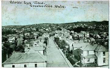
Photograph
On the map
Show this system's territory on the map — 2 ZIP codes in all.
Sources
U.S. EPA SDWIS and Community Water System Service Area Boundaries (v3, 2026), Ohio EPA primacy data, 2020 census blocks: the system serving most residents, traced through purchases to the treating utility; Ohio EPA 2023 Sewer and Water Rate Survey (Ohio State, May 2025) for household bills; Ohio EPA DEFA loan awards since 2016 for the loans paragraph · EPA SDWIS · EPA service area boundaries · Ohio EPA drinking water · Ohio EPA rate survey
Notable facts: crooksville.com, en.wikipedia.org
History: en.wikipedia.org, crooksville.com
Water quality: crooksville.com
Planned work: crooksville.com
Capital projects: crooksville.com
Rates: crooksville.com
Treatment: crooksville.com
Supply stress: crooksville.com