Local events in Chickasaw
Nothing is posted for Chickasaw itself yet; here is what is on within 10 miles. All local events in Chickasaw
Know a calendar we should watch? Send the link
Checked October 20; the events page is refreshed daily.
How Chickasaw began
Chickasaw was laid out in July 1838 by John Nutter and James Brooks in northern Marion Township, received a post office in 1840, and grew little until the Toledo, Delphos & Burlington railroad (later the Cincinnati, Hamilton & Dayton) came through in 1881; it was incorporated in 1890. It takes its name from Chickasaw Creek and, by local tradition, from a small band of Native people called Chickasaw who lived along the creek when settlers arrived. Before the railroad it was a stop on the plank road, now State Route 274, that carried grain from western Mercer County to the canal at New Bremen. Its Catholic church began as a weekday chapel in 1897 and became the separate parish of the Most Precious Blood in 1903; the parish's 1904 rectory and former school are on the National Register.
Platted 1838 (July), incorporated 1890, by John Nutter and James Brooks.
Where the name comes from
Named after the Chickasaw, per Wikipedia. The Mercer County Historical Society's 1959 history says a small band known as the Chickasaw lived on the higher ground along the stream that took their name, Chickasaw Creek, before white settlement; the village stands on that creek. A 2025 Daily Standard history adds a local tradition of individuals called "Big" and "Little" Chickasaw. The Chickasaw Nation's homeland lay far to the south, so the band's identity is recorded tradition rather than a documented finding.
Before the town
Chickasaw's name is its main piece of recorded Native history. The Mercer County Historical Society's 1959 history says that before white settlement a small band known as the Chickasaw lived on the higher ground along Chickasaw Creek, living by hunting, fishing and trapping, and that hundreds of arrowheads and other artifacts were later found on that ground; it also says the first settlers of neighboring Franklin Township found the same band. That history admits the band's presence "is not clearly understood." What is documented is that Chickasaw men were in this country during the Northwest Indian War: Howe's Historical Collections records that shortly before the attack on Fort Recovery at the end of June 1794, General Anthony Wayne sent out three small parties of Chickasaw and Choctaw scouts from Greenville to take prisoners, and two of them were in sight of the fort when the assault began. A 2025 Daily Standard history reports a further tradition that Chickasaw people were still living at the village in 1853; no primary record of that was found. A small cemetery near the village, the Iniard burial ground, has sometimes been taken for an Indian burial ground, but the 1959 history identifies it as the graveyard of a small English-speaking settler colony.
Nations recorded here: Chickasaw.
- Chickasaw Creek band's ground (tradition) (camp) — higher ground along Chickasaw Creek at and near the village, before white settlement in the 1830s (archive.org)
Timeline
- — The Chickasaw Nation signs the Treaty of Hopewell with the United States, formalizing an alliance that, per local tradition, is connected to the nation's later namesake presence at the Ohio village.
- — Before the attack on Fort Recovery, General Anthony Wayne sends three small parties of Chickasaw and Choctaw scouts out from Greenville; two of them are in sight of the fort when the assault begins.
- — Samuel Gray, Charles Botkin and John Miller, whose families had settled on Chickasaw Creek, are elected trustees at Marion Township's first election, held June 25, 1833.
- — Chickasaw is surveyed and laid out by John Nutter and James Brooks.
- — A post office is established at Chickasaw.
- — German Catholic settlers arrive via the Miami and Erie Canal, joining the village's original English and Irish settlers, by an earlier account we could not confirm.
- — Chickasaw people are said to be still living in the village of Chickasaw, per local historical research; no record of this was found.
- — The Toledo, Delphos & Burlington railroad, later the Cincinnati, Hamilton & Dayton, is built through Chickasaw, bringing the village its greatest prosperity.
- — Chickasaw incorporates as a village.
- — Catholics in Chickasaw build a church, used at first as a chapel for weekday services of St. Sebastian's parish.
- — The Chickasaw congregation is formally separated from St. Sebastian's and becomes the parish of the Most Precious Blood, with Rev. Anthony C. Tabke as its first pastor; an addition to the chapel costs $4,000.
- — St. Sebastian's church, the nearby mother parish at Sebastian, is destroyed by fire little more than a week after the Chickasaw members withdraw.
- — Precious Blood parish builds a brick rectory for about $4,000.
- — Scranton's county history lists three general stores, a sawmill, a wagon maker, the Union Handle Company, a hotel and two one-story brick school buildings in the village.
- — The eastern fork of a tornado from Darke County passes through Cranberry Prairie, St. Rosa and Chickasaw; the Lawrence Lochtefeld home half a mile east of the village is carried across the road.
- — A new cross-shaped brick Precious Blood church, begun in late 1965, is dedicated.
- — The Precious Blood rectory and the former parish school are listed on the National Register of Historic Places as the Chickasaw School and Rectory.
Stories
A Southeastern nation's name on an Ohio farm village
Of all the village names in Mercer County, Chickasaw is the hardest to explain by the usual pattern of German saints' days and Ohio-transplanted eastern place names. Local historical research credits the name to "Big" and "Little" Chickasaw, individuals said to have lived in the area when settlers, said to be English and Irish, first surveyed the village in 1838 -- an unusual claim, since the Chickasaw nation's documented homeland lay hundreds of miles south, in what is now Mississippi, Alabama and Tennessee. The Chickasaw had, however, allied closely with the United States: the nation signed the Treaty of Hopewell in 1786, and Chickasaw warriors under leaders like Chief James Underwood reportedly fought alongside Anthony Wayne's forces in the same Northwest Indian War campaign that produced Fort Recovery. Local researchers suggest that individuals from that alliance may have settled, or been allowed to remain, in Ohio rather than following the general Chickasaw removal route west in the 1830s -- and that Chickasaw people were still documented living in the village that bears their name as late as 1853. No academic source corroborating this tradition beyond the local newspaper account was found, so it is presented here as recorded local history rather than settled fact.
Hogs, grain and the plank road
Before the railroad, Chickasaw sat on a plank road, the forerunner of State Route 274, with a toll station in the village. Farmers from western Mercer County hauled hundreds of wagon loads of grain along it to the flour mills at New Bremen, where it was loaded onto Miami and Erie Canal boats. Hogs slaughtered across southern Mercer County were brought whole to the cellar of the Chickasaw flour mill and cut up there; the hams and shoulders were salted and shipped by canal to Cincinnati, and the side meat went to coal miners in West Virginia, while farmers took the heads, backbones and spareribs home for their own winter meat. The traffic supported taverns and hotels, and the society's 1959 history records an Underground Railroad stop at the east edge of the village before the Civil War. The railroad in 1881 replaced the road's trade, and a run of fires later destroyed the handle factory, the flour mill, the depot and a score of other buildings.
A parish split and a church fire
Chickasaw's Catholics first belonged to St. Sebastian's, nearly two miles to the northwest. In 1897 they built a small church in the village for weekday use, and because few villagers owned horses, support grew for a parish of their own. In January 1903 the Chickasaw members left St. Sebastian's, taking their belongings with them, and little more than a week later, on January 12, St. Sebastian's burned. The parish was divided: the remaining members rebuilt at Sebastian, and the Chickasaw chapel became the Church of the Most Precious Blood, with Rev. Anthony C. Tabke as pastor. The new parish enlarged the chapel that year, built a brick rectory in 1904, decided in 1908 to build a parish school, and had grown to 70 families by 1907.
Photographs
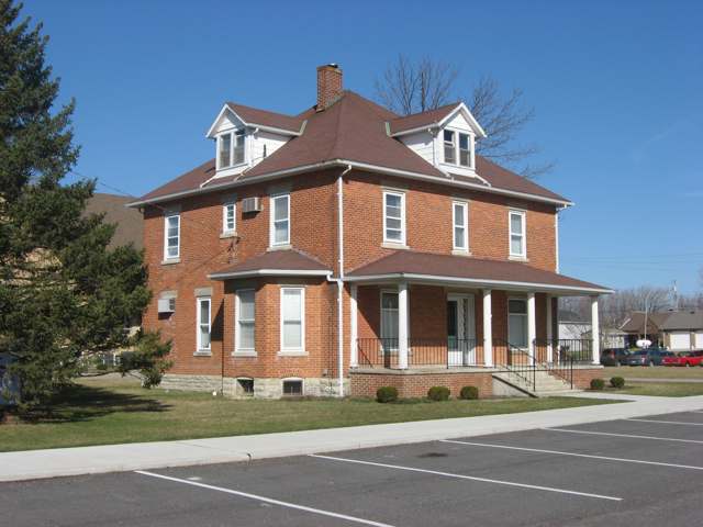
Photo: Nyttend (Wikimedia Commons), public domain · Wikimedia Commons
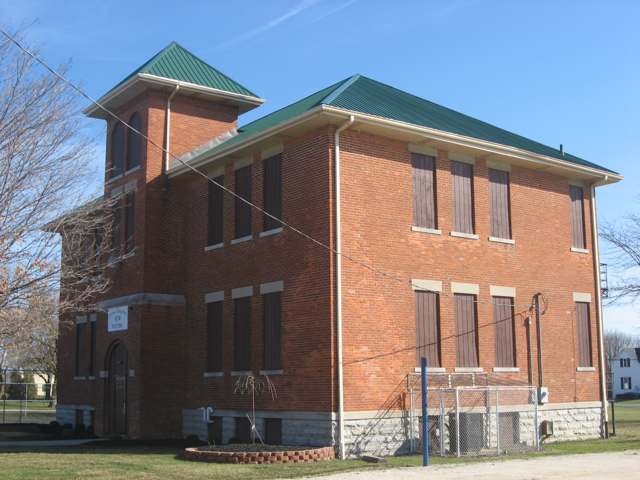
Photo: Nyttend (Wikimedia Commons), public domain · Wikimedia Commons
Local history sources: en.wikipedia.org · dailystandard.com · en.wikipedia.org · en.wikipedia.org · archive.org · archive.org · archive.org · en.wikipedia.org · archive.org · archive.org · archive.org · archive.org · commons.wikimedia.org · commons.wikimedia.org
Historic places
1 place in Chickasaw on the National Register of Historic Places. Press a pin or a name for its whole record.
-
Chickasaw School and RectoryBuilding · Chickasaw · listed 1979
- Address
- Maple St.
- Where
- Chickasaw, Mercer County · ZIP 45826
- What it is
- Building
- Listed on the National Register
- 1979
- NRIS reference number
- 79002848
- Coordinates
- 40.43624, -84.49302
National Register file (NPS) ↗ Search Wikipedia ↗ Street map and directions ↗ On the Cracked Buckeye map
Source: National Park Service, National Register of Historic Places point file. The listing year is shown where NPS's certification date agrees with the listing's reference number. Listing recognizes significance; it does not restrict a private owner.
Water
Groundwater wells (2 wells) The water here
- Chickasaw Village100% of residentsGroundwater wells (2 wells)
Hospitals, fire stations and more
Inside Chickasaw's boundary: 1 fire or EMS station, 1 library and 1 spill case. Press a pin or a name for its whole record and its source.
Fire and EMS stations (1)
-
Chickasaw Fire DepartmentCelina
- Address
- 97 South Roosevelt Street, Celina, OH 45822
- Coordinates
- 40.43375, -84.49391
USGS National Map structures (source) ↗ Street map and directions ↗
Source: USGS National Map structures (most Ohio records last updated 2019 to 2022), checked against the Columbus and Cleveland station lists. The department that answers a call is set by jurisdiction and mutual aid, not by distance.
Public libraries (1)
-
Marion Branch LibraryBranch · Chickasaw
- Address
- 5 E Franklin St, Chickasaw, OH 45826
- What it is
- Branch
- Library system
- Mercer County District Public Library
- Open
- 1,716 hours a year, 52 weeks
- Building
- 8,895 sq ft
- System's visits, FY2024
- 70,460
- System's loans, FY2024
- 275,641
- People the system serves
- 29,024
- Phone
- (419) 925-4966
IMLS Public Libraries Survey (source) ↗ Street map and directions ↗
Source: IMLS Public Libraries Survey FY2024 (outlets and their systems). Any Ohio resident can get a free card at any Ohio public library.
Spills reported since 2021 (1)
-
Oil Transformer Non Pcb2022-10-20 · Chickasaw
- Reported
- 2022-10-20
- What spilled
- Oil Transformer Non Pcb
- Largest amount reported
- 60 gallons
- Where
- Chickasaw, Mercer County
- Ohio EPA district office
- NWDO
- Ohio EPA case number
- 2210EPA0001580
Ohio EPA spill reports (source) ↗ Street map and directions ↗
Source: Ohio EPA emergency response spill reports, 2021 to September 2026, one point per case where Ohio EPA placed it. A report is what the caller or responder recorded; amounts are often blank or estimated.
Its ZIP codes
Each ZIP code that touches Chickasaw, with the share of its residents who live here and the same headline figures as the ZIP page.
| ZIP | Share | Water | Radon | Home value | Schools | Flood |
|---|---|---|---|---|---|---|
| 45826 Chickasaw | 98% | Groundwater wells (2 wells) | Too few radon tests | Median year built 1974 | Marion Local · 5 stars overall | 0.0% of residents in the 1% floodplain |
Local government
Who holds office in Chickasaw, how its elections and ballot issues came out, and the state auditor's record.
Elections for office
| Date | Office | Candidates and votes |
|---|---|---|
| 2023-11-07 | Member of Council | Nick Thobe 159, 56.58%; Shawn A. Birt 122, 43.42%; No Valid Petition Filed 0 |
| 2023-11-07 | Mayor | Ben Kramer 167, 100.0% |
Winners in bold. Results from the county board of elections' official canvass unless marked.
Auditor of State record
- No fiscal caution, watch or emergency on the Auditor of State's lists.
- Agreed Upon Procedures, 2022 to 2023, released 2024-12-03
The county
Mercer County: 10 ZIP codes, 23 cities, villages and townships, 42,566 people.
Nearby places
Rain and snow
How much has actually fallen on Chickasaw, day by day, from 1893 to now. Daily totals, not averages.
- rain, last 30 days
- 0.87 in
- 2026-09-30 to 2026-10-29
- rain so far in 2026
- 41.3 in
- 7.4 in above normal for the date
- snow so far in 2026
- 17.2 in
- a normal year brings 22.7 in
- a normal year
- 39.9 in
- average of 30 years, 1991-2020
| Month | Rain (in) | Snow (in) | Days counted |
|---|---|---|---|
| October 2026 | 0.87 | — | 29 |
| September 2026 | 6.61 | — | 30 |
| August 2026 | 10.70 | — | 31 |
| July 2026 | 3.12 | — | 31 |
| June 2026 | 4.08 | — | 30 |
| May 2026 | 5.25 | — | 31 |
| April 2026 | 3.78 | — | 30 |
| March 2026 | 5.01 | 0.9 | 31 |
| February 2026 | 0.83 | 4.9 | 28 |
| January 2026 | 1.10 | 11.3 | 31 |
| December 2025 | 1.70 | 8.9 | 31 |
| November 2025 | 1.55 | 4.4 | 30 |
| Wettest year | 2011 — 56.5 in |
|---|---|
| Driest year | 1934 — 22.7 in |
| Snowiest year | 2014 — 52.0 in |
| Wettest day on record | 13 July 1992 — 5.08 in |
| Heaviest snowfall in a day | 26 November 1950 — 15.19 in |
| Deepest snow on the ground | 6 February 1978 — 22.81 in |
Estimated, not measured. No rain gauge has ever stood inside Chickasaw, so every figure here is worked out from the gauges around it - the nearest ones weighted most. Treat them as close estimates rather than readings.
48,519 days of records, 1893-01-01 to 2026-10-29. Source: NOAA NCEI GHCN-Daily, 3,240 gauges in and around Ohio. A day is "gauged" when a gauge standing inside the boundary reported it, and the value is the mean of those gauges. Otherwise it is interpolated by inverse distance from every gauge reporting within 50 miles. Nothing is carried forward, back-filled or smoothed. Against NOAA nClimDiv county monthly precipitation over 136,848 complete county-months (checked 2026-10-31): correlation 0.9515, median absolute difference 0.217 in a month. Built 2026-10-31 from the Cracked Buckeye precipitation archive. Snow is the softer number — snowfall is measured by hand with a ruler, no agency publishes a gridded county snowfall series, and blowing snow defeats every observer.
Environmental permits and filings
What Ohio EPA has on file for Chickasaw: permits, inspections, violations, cleanups and the state loans behind sewer and water work. Every line links to the agency's own document.
- facilities and sites on file
- 5
- those placed on the map inside Chickasaw
| Program | Facilities and sites |
|---|---|
| State sewer loans | 2 |
| Air pollution | 1 |
| Hazardous waste | 1 |
| Public drinking water | 1 |
| Date | Facility or site | What |
|---|---|---|
| CHICKASAW VILLAGE PWS | Public drinking water compliance letter | |
| CHICKASAW VILLAGE PWS | Public drinking water inspection | |
| CHICKASAW VILLAGE PWS | Public drinking water inspection | |
| CHICKASAW VILLAGE PWS | Public drinking water report | |
| CHICKASAW VILLAGE PWS | Public drinking water plan | |
| CHICKASAW VILLAGE PWS | Public drinking water compliance letter | |
| CHICKASAW VILLAGE PWS | Public drinking water report | |
| CHICKASAW VILLAGE PWS | Public drinking water violation resolved | |
| CHICKASAW VILLAGE PWS | Public drinking water notice of violation | |
| CHICKASAW VILLAGE PWS | Public drinking water inspection | |
| CHICKASAW VILLAGE PWS | Public drinking water compliance letter | |
| CHICKASAW VILLAGE PWS | Public drinking water notice of violation | |
| CHICKASAW VILLAGE PWS | Public drinking water plan | |
| CHICKASAW VILLAGE PWS | Public drinking water notice of violation | |
| CHICKASAW VILLAGE PWS | Public drinking water notice of violation | |
| CHICKASAW VILLAGE PWS | Public drinking water compliance letter | |
| CHICKASAW VILLAGE PWS | Public drinking water report | |
| CHICKASAW VILLAGE PWS | Public drinking water notice of violation | |
| CHICKASAW VILLAGE PWS | Public drinking water inspection | |
| CHICKASAW VILLAGE PWS | Public drinking water inspection | |
| VILLAGE OF CHICKASAW PWS | Public drinking water compliance letter | |
| VILLAGE OF CHICKASAW PWS | Public drinking water permit | |
| VILLAGE OF CHICKASAW PWS | Public drinking water plan | |
| VILLAGE OF CHICKASAW PWS | Public drinking water inspection | |
| VILLAGE OF CHICKASAW PWS | Public drinking water notice of violation |
Source: Ohio EPA eDocument portal (edocpub.epa.ohio.gov), indexed 2026-10-14. Facilities are placed on the map from Ohio EPA's own map layers, EPA's Facility Registry, coordinates written in the filings, or a geocoded street address. A permit filed under a private person's name (most are household septic systems) is counted but never named, placed or linked; licenses for individual workers and open-burning notices are left out entirely.
Quick answers
What county is Chickasaw, Ohio in?
Chickasaw is a village in Mercer County, Ohio, with 351 residents.
When was Chickasaw, Ohio founded?
Chickasaw was laid out 1838 (July); incorporated 1890. Founders on record: John Nutter and James Brooks. Source
How did Chickasaw, Ohio get its name?
Named after the Chickasaw, per Wikipedia. Source
What ZIP code is Chickasaw, Ohio?
Most of Chickasaw is in ZIP code 45826.
Where does Chickasaw, Ohio get its water?
The main water source for Chickasaw (Chickasaw Village): Groundwater wells (2 wells).
Cite this page
Cite this page as:
Cracked Buckeye, "Chickasaw, Mercer County", https://crackedbuckeye.com/place/chickasaw/, built 2026-10-31, accessed [date].
How to cite · Report a correction · Built 2026-10-31
